close
-
Layers w
- Weather Layers
- Pro
- Pro
- Pro
- Pro
- Pro
- Pro
- More Layers
- Pro
- Pro
- Pro
- Pro
-
Upgrade to

3D
Trail Conditions
- Unknown
- Snow Groomed
- Snow Packed
- Snow Covered
- Snow Cover Partial
- Freeze/thaw Cycle
- Icy
- Prevalent Mud
- Wet
- Variable
- Ideal
- Dry
- Very Dry
Trail Flow (Ridden Direction)
Trailforks scans users ridelogs to determine the most popular direction each trail is ridden. A good flowing trail network will have most trails flowing in a single direction according to their intension.
The colour categories are based on what percentage of riders are riding a trail in its intended direction.
The colour categories are based on what percentage of riders are riding a trail in its intended direction.
- > 96%
- > 90%
- > 80%
- > 70%
- > 50%
- < 50%
- bi-directional trail
- no data
Trail Last Ridden
Trailforks scans ridelogs to determine the last time a trail was ridden.
- < 2 days
- < 1 week
- < 2 weeks
- < 1 month
- < 6 months
- > 6 months
Trail Ridden Direction
The intended direction a trail should be ridden.
- Downhill Only
- Downhill Primary
- Both Directions
- Uphill Primary
- Uphill Only
- One Direction
Contribute Details
Colors indicate trail is missing specified detail.
- Description
- Photos
- Description & Photos
- Videos
Trail Popularity ?
Trailforks scans ridelogs to determine which trails are ridden the most in the last 9 months.
Trails are compared with nearby trails in the same city region with a possible 25 colour shades.
Think of this as a heatmap, more rides = more kinetic energy = warmer colors.
- most popular
- popular
- less popular
- not popular
ATV/ORV/OHV Filter
Max Vehicle Width
inches
US Cell Coverage
Legend

Radar Time
Activity Recordings
Trailforks uses anonymized public activity data.
?
Activity Recordings
Trailforks uses anonymized public activity data.
?
Personal Heatmap
▶
Activity Types
all
/
none
▶
Options
2
Date range
month
–
Winter Trails
Warning
A routing network for winter maps does not exist. Selecting trails using the winter trails layer has been disabled.
Missing Trails
Most Popular
Least Popular
Trails are colored based on popularity. The more popular a trail is, the more red. Less popular trails trend towards green.
Jump Magnitude Heatmap
Heatmap of where riders jump on trails. Zoom in to see individual jumps, click circles to view jump details.
BC Backroad Status
![map legend]()
Service Road Atlas is a free to use, community-driven service for viewing and creating reports on the numerous back-country service roads around B.C. and Alberta.

Slope Aspect
Direction the slope faces
Trails Deemphasized
Trails are shown in grey.
Only show trails with no bike usage.
Suggested Layers
Based on selected activity type
Save the current map location and zoom level as your default home location whenever this page is loaded.
Save
No description for Méribel has been added yet!
Login or register to submit one.
This region uses the Uk/Euro style trail grading system.
Activities Click to view
- Mountain Bike
81 trails
- E-Bike
73 trails
- Gravel Bike
0 trails
- Adaptive Bike
0 trails
- Hike
65 trails
- Trail Running
66 trails
Region Details
- 11
- 4
- 13
- 30
- 10
- 2
Region Status
Open as of Apr 27, 2026Stats
- Avg Trail Rating
- Trails (view details)
- 80
- Trails Mountain Bike
- 81
- Trails E-Bike
- 73
- Trails Hike
- 66
- Trails Trail Running
- 66
- Total Distance
- 97 miles
- Total Descent
- 59,879 ft
- Total Vertical
- 7,697 ft
- Highest Trailhead
- 8,802 ft
- Reports
- 155
- Photos
- 233
- Ridden Counter
- 7,270
Articles
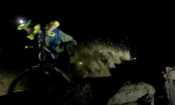
Video: Riding the Meribel World Cup Track at Night
Oct 27, 2019 from pinkbike.com
Strange things are afoot when night falls over the forests of Meribel.
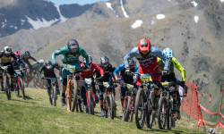
Details Announced for Maxiavalanche Méribel 2019
Aug 9, 2019 from pinkbike.com
Another weekend of mass start madness in Méribel.
Sub Regions
-
Méribel Bikepark
- 1
- 10
- 30
- 6
- 2
Popular Méribel Mountain Biking Trails
• 100 ★ 4.3 • 2 miles • 83 ft • 370 •
Highly rated popular blue difficulty family friendly alpine singletrack. This mountain bike primary trail can be used downhill only and has a moderate overall physical rating. It features berm, jump and roller coaster. Trail visibility is always easy to follow. On average it takes 17 minutes to complete this trail.
• 100 ★ 4.7 • 1 mile • 11 ft • 345 •
Highly rated popular blue difficulty family friendly alpine machine groomed. This mountain bike primary trail can be used downhill only and has a moderate overall physical rating. It features berm, bridge and jump. On average it takes 7 minutes to complete this trail.
• 100 ★ 4.7 • 2 miles • 23 ft • 295 •
Popular red difficulty alpine machine groomed. This mountain bike primary trail can be used downhill only and has a hard overall physical rating. It features berm, drop, jump, rock garden and roller coaster. On average it takes 10 minutes to complete this trail.
• 95 ★ 3.0 • 2,093 ft • 26 ft • 248 •
Popular black difficulty machine groomed. This mountain bike primary trail can be used downhill only and has a hard overall physical rating. It features berm, drop, jump, gap jump and wallride. On average it takes 1 minutes to complete this trail.
• 90 ★ 4.5 • 3 miles • 15 ft • 238 •
Popular blue difficulty alpine machine groomed. This mountain bike primary trail can be used downhill only. It features berm, bridge, jump, gap jump, pump track, rock garden and skinny. On average it takes 19 minutes to complete this trail.
• 85 ★ 4.5 • 4,682 ft • 6 ft • 232 • • hike
Popular black difficulty alpine singletrack. This hike primary trail can be used downhill primary. It features berm, drop, rock face, rock garden and skinny. On average it takes 9 minutes to complete this trail.
• 95 ★ 4.5 • 4,757 ft • 19 ft • 211 •
Highly rated popular black difficulty alpine singletrack. This mountain bike primary trail can be used downhill only and has a hard overall physical rating. It features berm, drop, jump, gap jump and roller coaster. On average it takes 5 minutes to complete this trail.
• 95 ★ 0.0 • 1 mile • 79 ft • 209 •
Popular blue difficulty machine groomed. This mountain bike primary trail can be used downhill only. It features berm and rock garden. On average it takes 4 minutes to complete this trail.
Méribel Mountain Bike Routes
24 miles • 5,147 ft • 0 • Loop •
FR Boucle depuis Saint Martin de Belleville passant par le Lac du Lou. Grosse montée reguilère jusqu'a...
3 miles • 526 ft • 0 •
★ 1.0 • 1 mile • 0 •
2 miles • 147 ft • 0 •
Photos of Méribel Mountain Bike
Videos of Méribel Mountain Bike
trail: Portage Col Du Fruit
0:18 |
5 |
Jul 9, 2025
trail: TopDown part 1
0:17 |
39 |
Jul 10, 2022

trail: La Ramée
39:59 |
28 |
Jul 15, 2025 , Méribel
trail: Le Fruit
39:59 |
35 |
Jul 15, 2025 , Méribel

trail: Descente De Chanrossa
39:59 |
68 |
Jul 15, 2025 , Méribel
trail: DH4 Tougnète Rocket
8:37 |
193 |
Sep 3, 2023 , Méribel
trail: BlueLine
14:15 |
211 |
Sep 1, 2023 , Méribel
Recent Trail Reports
| status | trail | date | condition | info | user |
|---|---|---|---|---|---|
| Les Crêtes | Apr 27, 2026 @ 11:30pm (Europe/Paris) Apr 27, 2026 | Snow Covered | BellevilleBikepark | ||
| Retour Piste | Aug 18, 2025 @ 1:45pm Aug 18, 2025 | Dry | Belinne | ||
| XC3 L'adret | Aug 18, 2025 @ 1:45pm Aug 18, 2025 | Ideal | Belinne | ||
| BlueLine Partie 3 | Aug 16, 2025 @ 10:40am Aug 16, 2025 | Ideal | lolo13430 | ||
| BlueLine Partie 2 | Aug 16, 2025 @ 10:40am Aug 16, 2025 | Ideal | lolo13430 | ||
| BlueLine | Aug 16, 2025 @ 10:40am Aug 16, 2025 | Ideal | lolo13430 | ||
| Mergolaz | Aug 10, 2025 @ 7:28am Aug 10, 2025 | Very Dry | Gustaafkn | ||
| TopDown #2 | Aug 3, 2025 @ 9:46am Aug 3, 2025 | Ideal | riotgrrrl | ||
| Top Down | Aug 3, 2025 @ 9:46am Aug 3, 2025 | Ideal | riotgrrrl | ||
| Le botanique (Forbidden july-august) | Aug 3, 2025 @ 9:46am Aug 3, 2025 | Variable | riotgrrrl |
Activity Feed
| username | action | type | title | date |
|---|---|---|---|---|
| BellevilleBikepark | add | report | activity #93540729 | Apr 27, 2026 @ 2:30pm Apr 27, 2026 |
| DavideOcchipinti | ridden | trail | activity #89610506 and 3 more | Feb 26, 2026 @ 9:12pm Feb 26, 2026 |
| Superfli | wishlist | route | activity #88100702 and 2 more | Jan 31, 2026 @ 10:54am Jan 31, 2026 |
| Meven81 | ridden | trail | activity #87849317 and 1 more | Jan 26, 2026 @ 9:03am Jan 26, 2026 |
| gilesmartin81 | wishlist | route | activity #85017209 | Dec 1, 2025 @ 9:11am Dec 1, 2025 |
Recent Comments
| username | type | title | comment | date |
|---|---|---|---|---|
| trail | Excellent trail, but only done due to the... | Aug 13, 2025 @ 2:47pm Aug 13, 2025 | ||
| trail | Closed due to forestry work not far before the... | Aug 13, 2025 @ 2:42pm Aug 13, 2025 | ||
| trail | Still crap, now also forestry works | Aug 10, 2025 @ 7:27am Aug 10, 2025 | ||
| trail | Tough switchbacks at the start | Aug 11, 2024 @ 10:38am Aug 11, 2024 | ||
| trail | High risk ridge riding followed by many (many)... | Aug 8, 2024 @ 5:14am Aug 8, 2024 |
Local Badges
-

Epic Ride Climb 2k618 awarded -

Climbing 10k Badge73 awarded -

Climbing 100k Badge1 awarded -

Epic Ride Descent 2k932 awarded -

Descent 10k Badge116 awarded -

Descent 100k Badge5 awarded
Bike & Skill Parks
| name | type | city | rating |
|---|---|---|---|
| Zone De Saut | skill park | Méribel |
Activity Type Stats
| activitytype | trails | distance | descent | descent distance | total vertical | rating | global rank | state rank | photos | reports | routes | ridelogs |
|---|---|---|---|---|---|---|---|---|---|---|---|---|
| Mountain Bike | 81 | 97 miles | 59,879 ft | 67 miles | 7,697 ft | #1,382 | #28 | 233 | 155 | 8 | 3,275 | |
| E-Bike | 73 | 88 miles | 52,789 ft | 60 miles | 7,697 ft | #1,150 | #88 | 146 | 4 | 399 | ||
| Hike | 65 | 79 miles | 47,123 ft | 52 miles | 7,697 ft | #1,574 | #38 | 146 | 299 | |||
| Trail Running | 66 | 79 miles | 47,123 ft | 52 miles | 7,697 ft | #1,348 | 146 | 46 |
Frequently Asked Questions About Méribel
▼
What are the best places to ride in Méribel?
Méribel has 1 areas to explore for mountain biking. The top rated areas are:
▼
What are the highest rated mountain biking trails in Méribel?
The highest rated mountain biking trails in Méribel are:
- Les Crêtes (4.4/5)
- DH9 WoodStoked (4.4/5)
- La Corbassière (4.3/5)
- DH7 La 7 (4.2/5)
- DH4 Tougnète Rocket (4.2/5)
▼
What is the best time of the year to ride in Méribel?
Based on ride log data, the most popular months to ride in Méribel are:
- August (30 activities)
- July (22 activities)
- May (2 activities)
▼
Where can I park to ride in Méribel?
Activities
Trails
- By brenthillier
 NSMBA TRAILFORKS & contributors
 - Admins: LSBP, freerider48, provencemb, fredhornybsm, Whipperman
- #4544 - 5,348 views
- méribel activity log | embed map of Méribel mountain bike trails | méribel mountain biking points of interest
Downloading of trail gps tracks in kml & gpx formats is enabled for Méribel.
You must login to download files.