close
-
Layers w
- Weather Layers
- Pro
- Pro
- Pro
- Pro
- Pro
- Pro
- More Layers
- Pro
- Pro
- Pro
- Pro
-
Upgrade to

3D
Trail Conditions
- Unknown
- Snow Groomed
- Snow Packed
- Snow Covered
- Snow Cover Partial
- Freeze/thaw Cycle
- Icy
- Prevalent Mud
- Wet
- Variable
- Ideal
- Dry
- Very Dry
Trail Flow (Ridden Direction)
Trailforks scans users ridelogs to determine the most popular direction each trail is ridden. A good flowing trail network will have most trails flowing in a single direction according to their intension.
The colour categories are based on what percentage of riders are riding a trail in its intended direction.
The colour categories are based on what percentage of riders are riding a trail in its intended direction.
- > 96%
- > 90%
- > 80%
- > 70%
- > 50%
- < 50%
- bi-directional trail
- no data
Trail Last Ridden
Trailforks scans ridelogs to determine the last time a trail was ridden.
- < 2 days
- < 1 week
- < 2 weeks
- < 1 month
- < 6 months
- > 6 months
Trail Ridden Direction
The intended direction a trail should be ridden.
- Downhill Only
- Downhill Primary
- Both Directions
- Uphill Primary
- Uphill Only
- One Direction
Contribute Details
Colors indicate trail is missing specified detail.
- Description
- Photos
- Description & Photos
- Videos
Trail Popularity ?
Trailforks scans ridelogs to determine which trails are ridden the most in the last 9 months.
Trails are compared with nearby trails in the same city region with a possible 25 colour shades.
Think of this as a heatmap, more rides = more kinetic energy = warmer colors.
- most popular
- popular
- less popular
- not popular
ATV/ORV/OHV Filter
Max Vehicle Width
inches
US Cell Coverage
Legend

Radar Time
Activity Recordings
Trailforks uses anonymized public activity data.
?
Activity Recordings
Trailforks uses anonymized public activity data.
?
Personal Heatmap
▶
Activity Types
all
/
none
▶
Options
2
Date range
month
–
Winter Trails
Warning
A routing network for winter maps does not exist. Selecting trails using the winter trails layer has been disabled.
Missing Trails
Most Popular
Least Popular
Trails are colored based on popularity. The more popular a trail is, the more red. Less popular trails trend towards green.
Jump Magnitude Heatmap
Heatmap of where riders jump on trails. Zoom in to see individual jumps, click circles to view jump details.
BC Backroad Status
![map legend]()
Service Road Atlas is a free to use, community-driven service for viewing and creating reports on the numerous back-country service roads around B.C. and Alberta.

Slope Aspect
Direction the slope faces
Trails Deemphasized
Trails are shown in grey.
Only show trails with no bike usage.
Suggested Layers
Based on selected activity type
Save the current map location and zoom level as your default home location whenever this page is loaded.
Save
No description for Merrill has been added yet!
Login or register to submit one.
Activities Click to view
- Mountain Bike
22 trails
- E-Bike
5 trails
- Gravel Bike
0 trails
- Adaptive Bike
0 trails
- Winter Fat Bike
0 trails
- Hike
23 trails
- Trail Running
22 trails
- Snowshoe
5 trails
- Nordic Ski
14 trails
Region Details
- 5
- 5
- 10
- 2
Region Status
Open as of Nov 3, 2024Stats
- Avg Trail Rating
- Trails (view details)
- 38
- Trails Mountain Bike
- 22
- Trails E-Bike
- 5
- Trails Horse
- 2
- Trails Hike
- 23
- Trails Trail Running
- 22
- Trails ATV/ORV/OHV
- 1
- Trails Snowshoe
- 5
- Trails Nordic Ski
- 14
- Total Distance
- 57 miles
- Total Descent Distance
- 18 miles
- Total Descent
- 4,252 ft
- Total Vertical
- 265 ft
- Highest Trailhead
- 1,660 ft
- Reports
- 53
- Photos
- 44
- Ridden Counter
- 1,044
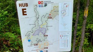
Sub Regions
-
Prairie Dells Loop
- 2
- 1
-
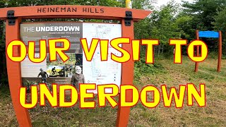
Underdown Recreation Area
- 3
- 9
- 2
Popular Merrill Mountain Biking Trails
• 65 ★ 3.0 • 9 miles • 966 ft • 321 •
Main loop of Underdown system starting from the north trailhead. West side of the loop has more modern improvements to make the climbing a little less difficult and the descending a whole lot more fun. East side of loop is more...
• 60 ★ 4.7 • 3 miles • 290 ft • 89 •
Get ready for a good test of legs and lungs! Coming from the south on Disconnector trail cross Horn Lake Road and begin to climb. Enjoy a stretch of rock garden and small descent for a quick rest then continue up. The trail is steep at...
• 85 ★ 4.5 • 5 miles • 578 ft • 84 •
Popular blue difficulty singletrack. This multi-use trail can be used both directions. On average it takes 25 minutes to complete this trail.
• 80 ★ 3.0 • 5 miles • 305 ft • 72 •
A ~5 mile loop on singletrack and some doubletrack located in the Merrill Memorial Forest, which is a 920-acre wildlife habitat area. The trail rolls through some hardwoods and across a bridge over the Manthei Marsh. This lso includes a...
• 90 ★ 4.5 • 3 miles • 156 ft • 54 •
Flowing trail traversing high ridges over glacial marsh/lake. Tricky Woo section includes jumps/drops with a do over option.
• 100 ★ 3.0 • 1,886 ft • 35 ft • 53 •
Connection from parking lot to south Underdown and Heinemania.
• 70 ★ 3.0 • 4,052 ft • 80 ft • 49 •
Rugged extra loop to add on some distance to the Loop. Semi in the beginning with some modern machine build towards the end.
• 55 ★ 5.0 • 3 miles • 180 ft • 48 •
More of the same punchy climbing and descending of this heavily glaciated region.
Merrill Mountain Bike Routes
8 miles • 416 ft • 3 • Loop •
This is a relatively simple route that loops and highlights the scenic Prairie River gorge. There are a...
8 miles • 416 ft • 3 • Loop •
Recommend parking at Prairie Dells or South Underdown trailheads. This route is similar to Underdown Lake...
32 miles • 2,779 ft • 7 • Loop •
This route utilizes all the mountain bike trails in Underdown and Prairie Dells trail systems. There are...
9 miles • 690 ft • 3 • Loop •
The Underdown Lake Loop is a great ride when you don't have all day to ride. It generally takes the locals...
9 miles • 943 ft • 1 • Loop •
Park at the Underdown Recreation Area off of Copper Lake Road. The route is gives you a taste of what the...
29 miles • 2,247 ft • 9 • Loop •
This route includes all the Underdown and Prairie Dells bike trails. The route is a loop and is best...
Photos of Merrill Mountain Bike
Videos of Merrill Mountain Bike
58:05 |
200 |
Apr 26, 2023
49:14 |
194 |
Apr 26, 2023
13:28 |
238 |
Sep 9, 2022
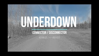
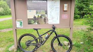
trail: Connector/Disconnector
34:35 |
474 |
May 9, 2021 , Merrill
Recent Trail Reports
| status | trail | date | condition | info | user |
|---|---|---|---|---|---|
| Prairie Dells Loop | Aug 25, 2024 @ 9:51am Aug 25, 2024 | Wet | Bgus1 | ||
| XTRA Credit | Jun 9, 2024 @ 5:47am Jun 9, 2024 | Ideal | Sturdyvw | ||
| The Hollow | Jun 9, 2024 @ 5:47am Jun 9, 2024 | Ideal | Sturdyvw | ||
| Tricky Woo do-over return | Jan 4, 2024 @ 8:29am Jan 4, 2024 | Variable | Candyj | ||
| Merrill Memorial Forest Road | Jan 4, 2024 @ 8:29am Jan 4, 2024 | Variable | Candyj | ||
| Heinemania | Jan 4, 2024 @ 8:29am Jan 4, 2024 | Variable | Candyj | ||
| Main Course | Jan 4, 2024 @ 8:17am Jan 4, 2024 | Ideal | Candyj | ||
| Connector/Disconnector | Jan 4, 2024 @ 8:17am Jan 4, 2024 | Ideal | Candyj | ||
| Doubletrack Connector | Jan 4, 2024 @ 8:17am Jan 4, 2024 | Ideal | Candyj | ||
| Connector | Jan 4, 2024 @ 8:17am Jan 4, 2024 | Ideal | Candyj |
Activity Feed
| username | action | type | title | date |
|---|---|---|---|---|
| cjzanon | wishlist | region | activity #96555210 | Jun 8, 2026 @ 11:54am Jun 8, 2026 |
| BURSTspeed | wishlist | region | activity #95666002 | May 27, 2026 @ 3:46pm May 27, 2026 |
| SterlingFBhn2D | wishlist | region | activity #95211986 | May 21, 2026 @ 5:34pm May 21, 2026 |
| AlCreamean | wishlist | trail | activity #92665047 | Apr 15, 2026 @ 9:20am Apr 15, 2026 |
| AlCreamean | wishlist | trail | activity #91821662 | Apr 3, 2026 @ 7:27am Apr 3, 2026 |
Recent Comments
| username | type | title | comment | date |
|---|---|---|---|---|
| trail | Someone with edit capability, please reverse... | Dec 28, 2025 @ 7:35am Dec 28, 2025 | ||
| trail | “Raw” wilderness/old school trail. Narrow... | Aug 6, 2025 @ 12:23pm Aug 6, 2025 | ||
| trail | Rode the full loop in June, CCW from the north... | Jun 17, 2025 @ 8:13am Jun 17, 2025 | ||
| trail | Thought this was going to be a flowy "Old... | Oct 13, 2023 @ 5:27pm Oct 13, 2023 | ||
| trail | Trailforks riding direction osd wrong. Start... | Sep 20, 2023 @ 4:41am Sep 20, 2023 |
Local Badges
-

10 Blue Trails22 awarded -

Epic Ride Climb 2k0 awarded -

Climbing 10k Badge5 awarded -

Climbing 100k Badge1 awarded -

Epic Ride Descent 2k0 awarded -

Descent 10k Badge5 awarded
Activity Type Stats
| activitytype | trails | distance | descent | descent distance | total vertical | rating | global rank | state rank | photos | reports | routes | ridelogs |
|---|---|---|---|---|---|---|---|---|---|---|---|---|
| Mountain Bike | 22 | 39 miles | 3,058 ft | 11 miles | 266 ft | #4,453 | #1,502 | 38 | 53 | 6 | 1,916 | |
| E-Bike | 5 | 9 miles | 466 ft | 2 miles | 79 ft | #8,173 | #2,481 | 31 | 2 | 9 | ||
| Horse | 2 | 1 mile | 125 ft | 3,248 ft | 95 ft | 2 | 1 | |||||
| Hike | 23 | 39 miles | 3,182 ft | 12 miles | 266 ft | #6,286 | #2,201 | 53 | 6 | 102 | ||
| Trail Running | 22 | 38 miles | 3,182 ft | 12 miles | 262 ft | #5,962 | #1,915 | 53 | 6 | 4 | ||
| ATV/ORV/OHV | 1 | 1,493 ft | 10 ft | 2 | 1 | |||||||
| Snowshoe | 5 | 6 miles | 499 ft | 2 miles | 217 ft | #1,612 | #918 | 7 | 1 | 14 | ||
| Nordic Ski | 14 | 17 miles | 1,070 ft | 6 miles | 102 ft | #1,037 | #440 | 21 |
Frequently Asked Questions About Merrill
▼
What are the best places to ride in Merrill?
Merrill has 2 areas to explore for mountain biking. The top rated areas are:
▼
What are the highest rated mountain biking trails in Merrill?
The highest rated mountain biking trails in Merrill are:
- Octoberfest (4.2/5)
- Winter Dike Trail (4.1/5)
- Winter River Trail (4.1/5)
- Old School (4.1/5)
- Heinemania (4.1/5)
▼
What is the best time of the year to ride in Merrill?
Based on ride log data, the most popular months to ride in Merrill are:
- April (11 activities)
- August (11 activities)
- May (9 activities)
▼
Where can I park to ride in Merrill?
There are 4 parking locations listed in Merrill. The most popular parking spots are: View all parking and trailhead locations on the map to plan your visit.
Activities
Trails
- By feardabeast
 TRAILFORKS & contributors
 - Admins: CWOCC
- #16217 - 3,266 views
- merrill activity log | embed map of Merrill mountain bike trails | merrill mountain biking points of interest
Downloading of trail gps tracks in kml & gpx formats is enabled for Merrill.
You must login to download files.