close
-
Layers w
- Weather Layers
- Pro
- Pro
- Pro
- Pro
- Pro
- Pro
- More Layers
- Pro
- Pro
- Pro
- Pro
-
Upgrade to

3D
Trail Conditions
- Unknown
- Snow Groomed
- Snow Packed
- Snow Covered
- Snow Cover Partial
- Freeze/thaw Cycle
- Icy
- Prevalent Mud
- Wet
- Variable
- Ideal
- Dry
- Very Dry
Trail Flow (Ridden Direction)
Trailforks scans users ridelogs to determine the most popular direction each trail is ridden. A good flowing trail network will have most trails flowing in a single direction according to their intension.
The colour categories are based on what percentage of riders are riding a trail in its intended direction.
The colour categories are based on what percentage of riders are riding a trail in its intended direction.
- > 96%
- > 90%
- > 80%
- > 70%
- > 50%
- < 50%
- bi-directional trail
- no data
Trail Last Ridden
Trailforks scans ridelogs to determine the last time a trail was ridden.
- < 2 days
- < 1 week
- < 2 weeks
- < 1 month
- < 6 months
- > 6 months
Trail Ridden Direction
The intended direction a trail should be ridden.
- Downhill Only
- Downhill Primary
- Both Directions
- Uphill Primary
- Uphill Only
- One Direction
Contribute Details
Colors indicate trail is missing specified detail.
- Description
- Photos
- Description & Photos
- Videos
Trail Popularity ?
Trailforks scans ridelogs to determine which trails are ridden the most in the last 9 months.
Trails are compared with nearby trails in the same city region with a possible 25 colour shades.
Think of this as a heatmap, more rides = more kinetic energy = warmer colors.
- most popular
- popular
- less popular
- not popular
ATV/ORV/OHV Filter
Max Vehicle Width
inches
US Cell Coverage
Legend

Radar Time
Activity Recordings
Trailforks uses anonymized public activity data.
?
Activity Recordings
Trailforks uses anonymized public activity data.
?
Personal Heatmap
▶
Activity Types
all
/
none
▶
Options
2
Date range
month
–
Winter Trails
Warning
A routing network for winter maps does not exist. Selecting trails using the winter trails layer has been disabled.
Missing Trails
Most Popular
Least Popular
Trails are colored based on popularity. The more popular a trail is, the more red. Less popular trails trend towards green.
Jump Magnitude Heatmap
Heatmap of where riders jump on trails. Zoom in to see individual jumps, click circles to view jump details.
BC Backroad Status
![map legend]()
Service Road Atlas is a free to use, community-driven service for viewing and creating reports on the numerous back-country service roads around B.C. and Alberta.

Slope Aspect
Direction the slope faces
Trails Deemphasized
Trails are shown in grey.
Only show trails with no bike usage.
Suggested Layers
Based on selected activity type
Save the current map location and zoom level as your default home location whenever this page is loaded.
Save
No description for Mesa has been added yet!
Login or register to submit one.
Activities Click to view
- Mountain Bike
164 trails
- E-Bike
11 trails
- Gravel Bike
1 trails
- Adaptive Bike
9 trails
- Winter Fat Bike
0 trails
- Horse
44 trails
- Hike
155 trails
- Trail Running
154 trails
Region Details
- 17
- 4
- 31
- 42
- 21
- 7
- 1
Region Status
Open as of Jun 20, 2026Local Trail Association
Stats
- Avg Trail Rating
- Trails (view details)
- 123
- Trails Mountain Bike
- 164
- Trails E-Bike
- 11
- Trails Gravel Bike
- 1
- Trails Adaptive Bike
- 9
- Trails Horse
- 44
- Trails Hike
- 155
- Trails Trail Running
- 154
- Total Distance
- 125 miles
- Total Descent
- 13,969 ft
- Total Vertical
- 1,460 ft
- Highest Trailhead
- 2,651 ft
- Reports
- 4,811
- Photos
- 1,088
- Ridden Counter
- 148,511
Articles

Arizona's 5 Most Popular Trail Networks According to Trailforks Data
Oct 19, 2021 from pinkbike.com
The American Southwest is chock full of bucket list locales, and perhaps no single southwestern state is home to more of them than Arizona.
Sub Regions
-
Brown Mountain
- 3
-
Desert Arroyo Park
- 2
- 2
-
Desert Trails Park
- 2
- 5
- 1
-
Hawes
- 21
- 36
- 22
- 6
- 1
Popular Mesa Mountain Biking Trails
• 100 ★ 4.4 • 4,793 ft • 257 ft • 4,448 •
Intermediate climb to access . Probably more difficult physically than technically, but does have a couple short steep sections that I have seen some riders walk. Uphill primary, ride as part of a counterclockwise loop with .
• 100 ★ 4.4 • 1 mile • 554 ft • 4,426 •
Highly rated popular blue difficulty singletrack. This multi-use trail can be used uphill primary and has a moderate overall physical rating with a 554 ft blue climb. Trail visibility is always easy to follow. On average it takes 24 minutes to complete this trail.
• 100 ★ 4.1 • 1,581 ft • 0 ft • 4,398 •
This is a super fun cut off of Wild Horse. This is a quick cut where if your are going downhill you can catch a good half dozen small to medium jumps and small gap jumps.
• 100 ★ 4.8 • 1 mile • 40 ft • 4,226 •
This is a predominantly downhill trail with bermed turned, rock drops & jumps!! Not recommended for hiking or uphill traffic. Please be aware!!
• 100 ★ 4.6 • 2,060 ft • 57 ft • 3,908 •
Contouring singletrack trail connecting to Cactus Garden. Parts of this trail were machine built, but most was hand built. Kudos to the Goat Herders for building an amazing trail!!
• 95 ★ 4.7 • 1 mile • 15 ft • 3,795 •
Primarily a downhill trail with a fair amount of flow. Some small rock features up top. This trail is a solid double-blue, but Trailforks doesn't have that rating capability, so it is rated higher in difficulty on the map to help...
• 100 ★ 4.0 • 1,493 ft • 51 ft • 3,475 •
Highly rated popular green difficulty singletrack. This multi-use trail can be used both directions and has a easy overall physical rating with a 51 ft green climb. Adaptive MTB rating: amtb green. Trail visibility is always easy to follow. On average it takes 2 minutes to complete this trail.
Mesa Mountain Bike Routes
★ 4.0 • 8 miles • 1,254 ft • 7 • Loop •
Parking is on power on the West side of the road. Optionally, by Walgreens or the Park and ride further...
★ 4.4 • 14 miles • 2,082 ft • 9 • Loop •
Three fast and flowy downhills, a sprinkling of tech, optional jumps, and huge banked turns. This...
★ 5.0 • 4 miles • 585 ft • 3 • Loop •
Quick loop that gets you some good DH on Mine trail. Easy pre or post work quick ride with a nice climb,...
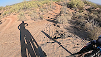
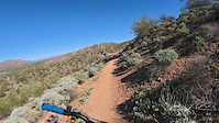
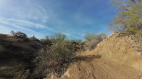
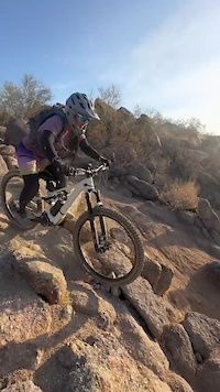
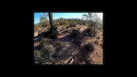
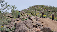
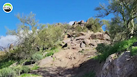
Photos of Mesa Mountain Bike
Videos of Mesa Mountain Bike
trail: RMR Extension
0:31 |
22 |
May 17, 2026
trail: Ridge
2:06 |
17 |
Nov 29, 2025
trail: Pure O
0:14 |
113 |
Mar 24, 2025
trail: Boulderdash
0:06 |
210 |
Jan 29, 2025
trail: Scorpion
7:59 |
96 |
May 11, 2024

trail: Pure O
0:13 |
9 |
Mar 14, 2024
trail: Boulderdash
0:11 |
942 |
Mar 27, 2023
trail: Sunset Ridge
0:13 |
752 |
Jan 23, 2023
Current Trail Warnings
| status | trail | date | condition | user | info |
|---|---|---|---|---|---|
| Hidden Valley | May 28, 2026 @ 10:58am (America/Phoenix) May 28, 2026 | Unknown | schillingsworth TRAILFORKS | Close corridor flagging. |
Recent Trail Reports
| status | trail | date | condition | info | user |
|---|---|---|---|---|---|
| Backbone | Jun 8, 2026 @ 6:32am (America/Phoenix) Jun 8, 2026 | Dry | schillingsworth TRAILFORKS | ||
| Mid-Mountain (S5) | Jun 6, 2026 @ 9:47pm (America/Phoenix) Jun 6, 2026 | Dry | schillingsworth TRAILFORKS | ||
| Twisted Sister (Lower) | May 29, 2026 @ 7:00am (America/Phoenix) May 29, 2026 | Dry | schillingsworth TRAILFORKS | ||
| Wild Horse | May 29, 2026 @ 7:00am (America/Phoenix) May 29, 2026 | Dry | schillingsworth TRAILFORKS | ||
| Bush Lite West | Jun 1, 2026 @ 7:48am (America/Phoenix) Jun 1, 2026 | Dry | Daveygee | ||
| Bush Lite East | Jun 1, 2026 @ 7:48am (America/Phoenix) Jun 1, 2026 | Dry | Daveygee | ||
| Scorpion | Jun 1, 2026 @ 7:48am (America/Phoenix) Jun 1, 2026 | Dry | Daveygee | ||
| Big Sister | May 30, 2026 @ 11:40am (America/Phoenix) May 30, 2026 | Dry | gossetts | ||
| Bush Hwy. Access | May 30, 2026 @ 11:40am (America/Phoenix) May 30, 2026 | Dry | gossetts | ||
| Rush Back | May 26, 2026 @ 8:38am (America/Phoenix) May 26, 2026 | Dry | schillingsworth TRAILFORKS |
Activity Feed
| username | action | type | title | date |
|---|---|---|---|---|
| Coop2010 | ridden | poi | activity #97669949 | Jun 23, 2026 @ 7:35pm 18 hours |
| spicytaco | wishlist | trail | activity #97605315 and 1 more | Jun 22, 2026 @ 10:08pm 2 days |
| spicytaco | wishlist | route | activity #97605272 | Jun 22, 2026 @ 10:06pm 2 days |
| NathanCollinsR | wishlist | trail | activity #97604703 | Jun 22, 2026 @ 9:47pm 2 days |
| Stomper777 | wishlist | region | activity #97520955 | Jun 21, 2026 @ 2:27pm 3 days |
Recent Comments
| username | type | title | comment | date |
|---|---|---|---|---|
| trail | Rode the new connector off High Noon to lower... | May 17, 2026 @ 5:52pm May 17, 2026 | ||
| trail | There is features that need alot - alot of... | May 14, 2026 @ 10:41am May 14, 2026 | ||
| trail | Needs time, water, and more riders. | May 14, 2026 @ 10:39am May 14, 2026 | ||
| trail | Very loose, needs time and water and more riders.. | May 14, 2026 @ 10:38am May 14, 2026 | ||
| trail | Well, this is awesome! | May 5, 2026 @ 6:49pm May 5, 2026 |
Local Badges
-

Hawes Baker's Dozen47 awarded -

Descent 100k Badge69 awarded -

Descent 10k Badge787 awarded -

Big Ride 30k20,785 awarded -

Epic Ride 50k7,237 awarded -

Top 10 Trails96 awarded
Bike & Skill Parks
| name | type | city | rating |
|---|---|---|---|
| Desert Trails Park | skill park | Mesa |
Activity Type Stats
| activitytype | trails | distance | descent | descent distance | total vertical | rating | global rank | state rank | photos | reports | routes | ridelogs |
|---|---|---|---|---|---|---|---|---|---|---|---|---|
| Mountain Bike | 164 | 125 miles | 13,970 ft | 47 miles | 1,460 ft | #62 | #23 | 1,090 | 4,814 | 101 | 199,485 | |
| E-Bike | 11 | 40 miles | 135 ft | 7 miles | 131 ft | #513 | #723 | 13 | 3,527 | 12 | 13,515 | |
| Gravel Bike | 1 | #292 | #913 | 20 | 751 | |||||||
| Adaptive Bike | 9 | #255 | #1,557 | 10 | 5 | |||||||
| Horse | 44 | 28 miles | 906 ft | 5 miles | 899 ft | #740 | #563 | 686 | 2 | 247 | ||
| Hike | 155 | 123 miles | 13,599 ft | 46 miles | 1,460 ft | #836 | #381 | 22 | 4,802 | 6 | 6,215 | |
| Trail Running | 154 | 123 miles | 13,599 ft | 46 miles | 1,460 ft | #418 | #167 | 2 | 4,800 | 12 | 2,635 |
Frequently Asked Questions About Mesa
▼
What are the best places to ride in Mesa?
Mesa has 4 areas to explore for mountain biking. The top rated areas are:
▼
What are the highest rated mountain biking trails in Mesa?
The highest rated mountain biking trails in Mesa are:
- Big Sister (4.7/5)
- Red Mountain Rush (4.6/5)
- Maricopa Madness (4.6/5)
- Boulderdash (4.5/5)
- Iron Goat (4.5/5)
▼
What is the best time of the year to ride in Mesa?
Based on ride log data, the most popular months to ride in Mesa are:
- February (1,524 activities)
- December (1,465 activities)
- March (1,277 activities)
▼
Where can I park to ride in Mesa?
There are 17 parking locations listed in Mesa. The most popular parking spots are: View all parking and trailhead locations on the map to plan your visit.
Activities
Trails
Points of Interest
- Left Hook Drop TTF
- Mine Shaft (actual location) Other
- DG Garden TTF
- Ride the Wall TTF
- Dragons Back TTF
- Split the Rock TTF
- Garden of Rocks/big gap/smaller lefty gap/rock skinny TTF
- Ovaries Tabletop TTF
- Drainage Gap TTF
- Double the Slab TTF
- Pass Mountain (3,307 ft)
- Peak 3004 (2,959 ft)
- Usery Mountain (2,946 ft)
- By canadaka
 Trailforks & contributors
 - Admins: AZT, chainslapAZ, schillingsworth, jeffgicklhorn, jpmcghee, msmcfate, cemoorelife, Schwinnshralper26
- #5001 - 58,351 views
- mesa activity log | embed map of Mesa mountain bike trails | mesa mountain biking points of interest polygons
Downloading of trail gps tracks in kml & gpx formats is enabled for Mesa.
You must login to download files.