close
-
Layers w
- Weather Layers
- Pro
- Pro
- Pro
- Pro
- Pro
- Pro
- More Layers
- Pro
- Pro
- Pro
- Pro
-
Upgrade to

3D
Trail Conditions
- Unknown
- Snow Groomed
- Snow Packed
- Snow Covered
- Snow Cover Partial
- Freeze/thaw Cycle
- Icy
- Prevalent Mud
- Wet
- Variable
- Ideal
- Dry
- Very Dry
Trail Flow (Ridden Direction)
Trailforks scans users ridelogs to determine the most popular direction each trail is ridden. A good flowing trail network will have most trails flowing in a single direction according to their intension.
The colour categories are based on what percentage of riders are riding a trail in its intended direction.
The colour categories are based on what percentage of riders are riding a trail in its intended direction.
- > 96%
- > 90%
- > 80%
- > 70%
- > 50%
- < 50%
- bi-directional trail
- no data
Trail Last Ridden
Trailforks scans ridelogs to determine the last time a trail was ridden.
- < 2 days
- < 1 week
- < 2 weeks
- < 1 month
- < 6 months
- > 6 months
Trail Ridden Direction
The intended direction a trail should be ridden.
- Downhill Only
- Downhill Primary
- Both Directions
- Uphill Primary
- Uphill Only
- One Direction
Contribute Details
Colors indicate trail is missing specified detail.
- Description
- Photos
- Description & Photos
- Videos
Trail Popularity ?
Trailforks scans ridelogs to determine which trails are ridden the most in the last 9 months.
Trails are compared with nearby trails in the same city region with a possible 25 colour shades.
Think of this as a heatmap, more rides = more kinetic energy = warmer colors.
- most popular
- popular
- less popular
- not popular
ATV/ORV/OHV Filter
Max Vehicle Width
inches
US Cell Coverage
Legend

Radar Time
Activity Recordings
Trailforks uses anonymized public activity data.
?
Activity Recordings
Trailforks uses anonymized public activity data.
?
Personal Heatmap
▶
Activity Types
all
/
none
▶
Options
2
Date range
month
–
Winter Trails
Warning
A routing network for winter maps does not exist. Selecting trails using the winter trails layer has been disabled.
Missing Trails
Most Popular
Least Popular
Trails are colored based on popularity. The more popular a trail is, the more red. Less popular trails trend towards green.
Jump Magnitude Heatmap
Heatmap of where riders jump on trails. Zoom in to see individual jumps, click circles to view jump details.
BC Backroad Status
![map legend]()
Service Road Atlas is a free to use, community-driven service for viewing and creating reports on the numerous back-country service roads around B.C. and Alberta.

Slope Aspect
Direction the slope faces
Trails Deemphasized
Trails are shown in grey.
Only show trails with no bike usage.
Suggested Layers
Based on selected activity type
Save the current map location and zoom level as your default home location whenever this page is loaded.
SavePopular Trail Networks
view all areas »
No description for Metro Region has been added yet!
Login or register to submit one.
Stats
- Avg Trail Rating
- Trails (view details)
- 1,745
- Trails Mountain Bike
- 1,161
- Trails E-Bike
- 931
- Trails Gravel Bike
- 10
- Trails Horse
- 119
- Trails Hike
- 1,495
- Trails Trail Running
- 1,496
- Trails Snowmobile
- 11
- Trails Snowshoe
- 633
- Trails Downhill Ski
- 94
- Trails Backcountry Ski
- 13
- Trails Nordic Ski
- 761
- Total Distance
- 1,481 miles
- Total Descent
- 58,032 ft
- Total Vertical
- 504 ft
- Highest Trailhead
- 1,182 ft
- Reports
- 5,561
- Photos
- 597
- Ridden Counter
- 180,134
Articles
The Best Mountain Biking in Minnesota
Aug 22, 2024 from outsideonline.com
World-class riding is the state’s best-kept secret. These are the top trails, according to a local expert.
This Hiking Paradise In The Heartland Flies Under The Radar
Aug 19, 2024 from backpacker.com
Want in on one of the Midwest’s best-kept secrets for urban hiking? These Minneapolis trails offer the best in the Heartland.

Interview: Wesley Ferguson on Mountain Biking as a Black Man
Oct 23, 2020 from pinkbike.com
Wesley works at a non-profit bike shop in Minneapolis that's working to improve diversity in the cycling world, and he's recently gotten into...
Destination Showcase: Duluth & Lebanon Hills, Minnesota
Aug 7, 2019 from pinkbike.com
Check out two more of the top places to mountain bike in Minnesota.
Sub Regions
- Anoka County (535)
- Andover (54)
- Anoka (40)
- Bethel (13)
- Haunted Forest (9)
- Blaine (92)
- Centerville (25)
- Coon Rapids (112)
- East Bethel (6)
- Fridley (20)
- Ramsey (50)
- Saint Francis (6)
- Carver County (90)
- Channassen (10)
- Chaska (34)
- Shorewood (14)
- Waconia (27)
- Chisago County (11)
- Lindstrom (4)
- North Branch (9)
- Taylor Falls (7)
- Dakota County (89)
- Burnsville (12)
- Buck Hill (7)
- Terrace Oaks (4)
- Eagan (32)
- Farmington (0)
- Hastings (16)
- Inver Grove Heights (6)
- Salem Hills Park (6)
- Lakeville (23)
- south st. paul (3)
- Kaposia Landing (3)
- Burnsville (12)
- Hennepin County (210)
- Bloomington (69)
- Champlin (24)
- Elm Creek Park (14)
- Edina (10)
- Braemar Park (10)
- Minneapolis (61)
- Minnetonka (28)
- Big Willow Park (12)
- Bredesen Park (1)
- Byrant Luke Regional Park (3)
- Lone Lake Park (5)
- Purgatory Park (2)
- Staring Lake Park (5)
- Plymouth (0)
- Richfield (1)
- Taft Bike Park (1)
- Rockford (10)
- Lake Rebecca (15)
- Wazyata (1)
- Ramsey County (104)
- Scott County (14)
- Savage (14)
- Murphy-Hanrehan Park (12)
- Savage (14)
- Sherburne County (7)
- Elk River (7)
- Hillside Park (7)
- Elk River (7)
- Washington County (91)
- Afton (4)
- Afton State Park (5)
- Cottage Grove (9)
- Lake Elmo (37)
- Lake Elmo Park Reserve (29)
- Reid Park (1)
- Sunfish Lake Park (5)
- Marine On St.Croix (1)
- Oakdale (4)
- Stillwater (5)
- Valley View Park (1)
- Woodbury (39)
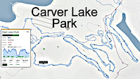
- Carver Lake Park (23)
- Afton (4)
- Maplewood (2)
- 3M Center (2)
- Prior Lake (3)
- Shakopee (11)
Popular Metro Region Mountain Biking Trails
• 85 ★ 4.5 • 5 miles • 460 ft • 1,754 •
This is a more advanced blue trail that will challenge riders. The trail has drops, flow, rock gardens and some punchy climbs. Its the gem of the twin cities.
• 95 ★ 4.4 • 3,232 ft • 37 ft • 1,738 •
The green trail at Lebanon Hills is a family friendly warm up trail that can be looped for inexperienced rides and leads to the entrance. The trails are all smooth with very gradual ups and downs. Great place to twist through the big...
• 25 ★ 0.0 • 4,603 ft • 43 ft • 1,682 •
Double track connecting multiple trails. Mostly dirt and grass.
• 100 ★ 2.5 • 781 ft • 19 ft • 1,602 •
Popular black diamond difficulty singletrack. This mountain bike primary trail can be used one direction. It features rock garden. On average it takes minutes to complete this trail.
• 90 ★ 4.2 • 1 mile • 86 ft • 1,563 •
This is a great beginner trail that adds in some fun swooping berms and little options fast sections. Lots of fun trails for beginners to learn and perfect for riding with the family.
• 80 ★ 4.4 • 2,772 ft • 53 ft • 1,468 •
This is a really fun way to finish the day. It starts with a stiff climb and some embedded rocks to negotiate. At the top of the climb is a log pile that is very difficult to clean. You have to punch it hard and try to coast up over by...
• 90 ★ 4.7 • 1 mile • 80 ft • 1,392 •
Highly rated popular black diamond difficulty singletrack. This mountain bike primary trail. It features drop, log ride and rock garden. On average it takes 9 minutes to complete this trail.
• 100 ★ 3.9 • 6 miles • 325 ft • 1,363 •
This is a very mellow blue (aqua?) trail, relatively smooth, rolling through the woods and meadows, with a number of narrowish sections and a few small bumps/jumps scattered around. The trail sees very heavy use, and is many rider's...
Metro Region Mountain Bike Routes
1 mile • 15 ft • 2 • Loop •
This is the easiest loop that you can do at Xcel. It is a great introduction for a beginner to mountain...
★ 4.0 • 9 miles • 1,172 ft • 36 • Loop •
A 10-mile loop at Battle Creek including the new connector trails to Big Wheezy Honeybadger.
2 miles • 42 ft • 2 • Loop •
This is the second easiest loop at Xcel Energy Mountain Bike Park. This route jumps on the for a short...
2 miles • 48 ft • 2 • Loop •
Loop around Bunker Lake with short boardwalk in the northeast corner.
10 miles • 1,300 ft • 21 • Loop •
This loop plays the BC hits in a reasonable to navigate fashion
5 miles • 294 ft • 1 • Loop •
This is an easy route to hit all the trails at Carver on a mountain bike.
Photos of Metro Region Mountain Bike
Videos of Metro Region Mountain Bike
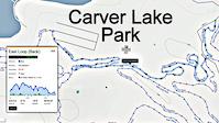
trail: North Loop Advanced Spur 2
0:05 |
160 |
Nov 21, 2023
trail: Apple
0:07 |
67 |
Aug 1, 2022
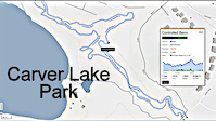
trail: Controlled Berm
4:07 |
64 |
Dec 1, 2021
trail: The Pines
4:11 |
27 |
Dec 1, 2021
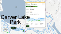
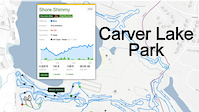
trail: Shore Shimmy
2:12 |
22 |
Dec 1, 2021
trail: Shore Shimmy
5:32 |
32 |
Nov 30, 2021
trail: Renegade Run
6:30 |
44 |
Nov 29, 2021
6:08 |
57 |
Nov 29, 2021
Current Trail Warnings
| status | trail | date | condition | user | info |
|---|---|---|---|---|---|
| SH B Loop Salem Hills Park | Jun 20, 2026 @ 5:48pm (America/Chicago) 1 day | Ideal | XsGkpV | Fallen tree, see red mark on attached photo | |
| Sasquatch Highlands Rice Creek Chain Of Lakes Park | Jun 4, 2026 @ 5:08pm (America/Chicago) Jun 4, 2026 | Unknown | Siredwardmuddy | County has installed signs excluding all... | |
| Brownie Lake Theodore Wirth Park | Jun 2, 2026 @ 1:19pm (America/Chicago) Jun 2, 2026 | Ideal | chucknasty | Couple of trees down and overgrown in places |
Recent Trail Reports
Activity Feed
| username | action | type | title | date |
|---|---|---|---|---|
| DDRIII | add | report | activity #97526104 and 1 more | Jun 21, 2026 @ 3:36pm 2 hours |
| Cjibsnow | add | photo | activity #97521302 and 1 more | Jun 21, 2026 @ 2:31pm 3 hours |
| nolantheg | add | photo | activity #97452969 and 7 more | Jun 20, 2026 @ 8:29pm 21 hours |
| Masterof24 | ridden | trail | activity #97441051 | Jun 20, 2026 @ 4:20pm 1 day |
| XsGkpV | add | report | activity #97438670 and 1 more | Jun 20, 2026 @ 3:42pm 1 day |
Recent Comments
| username | type | title | comment | date |
|---|---|---|---|---|
| trail | The arrows on trailforks are in the wrong... | Jun 7, 2026 @ 7:29am Jun 7, 2026 | ||
| trail | Neat section with some rock gardens, a couple... | May 30, 2026 @ 6:27pm May 30, 2026 | ||
| trail | Wish there was trail here. Unsafe for the littles. | May 30, 2026 @ 6:26pm May 30, 2026 | ||
| trail | Fantastic flowy line with nicely sized varied... | May 30, 2026 @ 6:24pm May 30, 2026 | ||
| trail | Great for beginners, jumps just big enough to... | May 30, 2026 @ 6:22pm May 30, 2026 |
Local Badges
-
West Lake Marion Legend0 awarded -

Mountain Biking 100k Badge0 awarded -
Mountain Biking 100k Badge0 awarded -
Mountain Biking 100k Badge0 awarded -
Mountain Biking 100k Badge0 awarded -

Epic Ride Descent 2k0 awarded
Bike & Skill Parks
| name | type | city | rating |
|---|---|---|---|
| Afton Alps | bike park | Afton | |
| Cottage Grove Bike Park | skill park | Cottage Grove | |
| Lebanon Hills Skill Park | skill park | Eagan | |
| Carver Lake Bike Park Playground | skill park | Woodbury | |
| Perkins Hill Pumptrack | skill park | Minneapolis |
Activity Type Stats
| activitytype | trails | distance | descent | descent distance | total vertical | rating | global rank | state rank | photos | reports | routes | ridelogs |
|---|---|---|---|---|---|---|---|---|---|---|---|---|
| Mountain Bike | 1,161 | 1,111 miles | 34,534 ft | 323 miles | 499 ft | 562 | 5,511 | 19 | 275,074 | |||
| E-Bike | 931 | 896 miles | 23,107 ft | 256 miles | 407 ft | 4,709 | 5 | 6,075 | ||||
| Gravel Bike | 10 | 15 miles | 423 ft | 4 miles | 335 ft | 157 | 3 | 1,281 | ||||
| Horse | 119 | 119 miles | 5,052 ft | 42 miles | 430 ft | 816 | 1 | 30 | ||||
| Hike | 1,493 | 1,366 miles | 46,184 ft | 410 miles | 446 ft | 31 | 5,419 | 7 | 8,915 | |||
| Trail Running | 1,496 | 1,366 miles | 46,207 ft | 410 miles | 446 ft | 5,418 | 4 | 10,452 | ||||
| Snowmobile | 11 | 20 miles | 643 ft | 6 miles | 312 ft | 40 | ||||||
| Snowshoe | 633 | 429 miles | 11,217 ft | 124 miles | 374 ft | 174 | 494 | |||||
| Downhill Ski | 90 | 27 miles | 6,732 ft | 14 miles | 479 ft | 40 | 1,030 | |||||
| Backcountry Ski | 13 | 11 miles | 184 ft | 3 miles | 144 ft | 40 | 91 | |||||
| Nordic Ski | 761 | 504 miles | 14,934 ft | 149 miles | 446 ft | 1 | 195 | 12,389 |
Activities
- Metro Region Mountain Biking Trails
- Metro Region E-Biking Trails
- Metro Region Gravel Biking Trails
- Metro Region Horseback Trails
- Metro Region Hiking Trails
- Metro Region Trail Running Trails
- Metro Region Snowmobiling Trails
- Metro Region Snowshoeing Trails
- Metro Region Skiing Trails
- Metro Region Backcountry Skiing Trails
- Metro Region Nordic Skiing Trails
Trails
- By brenthillier
 NSMBA TRAILFORKS & contributors
 - Admins: MW HIKING, namdoogttam, Redpine, CycleKrieg, mnmtb
- #12009 - 9,445 views
- metro region activity log | embed map of Metro Region mountain bike trails | metro region mountain biking points of interest polygons
Downloading of trail gps tracks in kml & gpx formats is enabled for Metro Region.
You must login to download files.