close
-
Layers w
- Weather Layers
- Pro
- Pro
- Pro
- Pro
- Pro
- Pro
- More Layers
- Pro
- Pro
- Pro
- Pro
-
Upgrade to

3D
Trail Conditions
- Unknown
- Snow Groomed
- Snow Packed
- Snow Covered
- Snow Cover Partial
- Freeze/thaw Cycle
- Icy
- Prevalent Mud
- Wet
- Variable
- Ideal
- Dry
- Very Dry
Trail Flow (Ridden Direction)
Trailforks scans users ridelogs to determine the most popular direction each trail is ridden. A good flowing trail network will have most trails flowing in a single direction according to their intension.
The colour categories are based on what percentage of riders are riding a trail in its intended direction.
The colour categories are based on what percentage of riders are riding a trail in its intended direction.
- > 96%
- > 90%
- > 80%
- > 70%
- > 50%
- < 50%
- bi-directional trail
- no data
Trail Last Ridden
Trailforks scans ridelogs to determine the last time a trail was ridden.
- < 2 days
- < 1 week
- < 2 weeks
- < 1 month
- < 6 months
- > 6 months
Trail Ridden Direction
The intended direction a trail should be ridden.
- Downhill Only
- Downhill Primary
- Both Directions
- Uphill Primary
- Uphill Only
- One Direction
Contribute Details
Colors indicate trail is missing specified detail.
- Description
- Photos
- Description & Photos
- Videos
Trail Popularity ?
Trailforks scans ridelogs to determine which trails are ridden the most in the last 9 months.
Trails are compared with nearby trails in the same city region with a possible 25 colour shades.
Think of this as a heatmap, more rides = more kinetic energy = warmer colors.
- most popular
- popular
- less popular
- not popular
ATV/ORV/OHV Filter
Max Vehicle Width
inches
US Cell Coverage
Legend

Radar Time
Activity Recordings
Trailforks uses anonymized public activity data.
?
Activity Recordings
Trailforks uses anonymized public activity data.
?
Personal Heatmap
▶
Activity Types
all
/
none
▶
Options
2
Date range
month
–
Winter Trails
Warning
A routing network for winter maps does not exist. Selecting trails using the winter trails layer has been disabled.
Missing Trails
Most Popular
Least Popular
Trails are colored based on popularity. The more popular a trail is, the more red. Less popular trails trend towards green.
Jump Magnitude Heatmap
Heatmap of where riders jump on trails. Zoom in to see individual jumps, click circles to view jump details.
BC Backroad Status
![map legend]()
Service Road Atlas is a free to use, community-driven service for viewing and creating reports on the numerous back-country service roads around B.C. and Alberta.

Slope Aspect
Direction the slope faces
Trails Deemphasized
Trails are shown in grey.
Only show trails with no bike usage.
Suggested Layers
Based on selected activity type
Save the current map location and zoom level as your default home location whenever this page is loaded.
SavePopular Trail Networks
view all areas »
No description for México has been added yet!
Login or register to submit one.
AKA: Mexico
Region Details
- 524
- 46
- 653
- 1,199
- 480
- 87
- 13
Stats
- Avg Trail Rating
- Trails (view details)
- 3,084
- Trails Mountain Bike
- 3,003
- Trails E-Bike
- 2,072
- Trails Gravel Bike
- 219
- Trails Adaptive Bike
- 395
- Trails Winter Fat Bike
- 219
- Trails Horse
- 304
- Trails Hike
- 2,410
- Trails Trail Running
- 2,385
- Trails Dirtbike/Moto
- 162
- Trails Observed Trials
- 34
- Trails ATV/ORV/OHV
- 96
- Trails Snowmobile
- 3
- Trails Snowshoe
- 3
- Trails Downhill Ski
- 3
- Trails Backcountry Ski
- 3
- Trails Nordic Ski
- 9
- Total Distance
- 4,137 miles
- Total Descent
- 1,011,129 ft
- Total Vertical
- 18,375 ft
- Highest Trailhead
- 18,375 ft
- Reports
- 12,807
- Photos
- 6,272
- Ridden Counter
- 162,711
Articles
Jungle Loam & Desert Descents: Inside the Into The Gnar Oaxaca Expedition
Apr 22, 2026 from pinkbike.com
Jungle loam, desert surfing, and Michelin-star meals - Holly Duncan joins Yoann Barelli and Nate Spitz for a week of cultural immersion in Mexico.
Event Report: Big Air & Good Times at Freeride Fiesta 2026
Jan 28, 2026 from pinkbike.com
An event that feels like a cultural exchange between the global freeride scene and the local community.
Race Report: Transierra Norte 2025
Nov 6, 2025 from pinkbike.com
The five-day journey from pines to playas.
Video: The Propain Positive Crew Hit Red Bull Cerro Abajo in Guanajuato, Mexico
Apr 7, 2025 from pinkbike.com
This team is fun.
Sub Regions
- Aguascalientes (State) (125)
- Aguascalientes (Municipality) (125)
- Aguascalientes (125)
- Aguascalientes (Municipality) (125)
- Baja California (State) (8)
- Ensenada (Municipality) (4)
- Ensenada (3)
- San Felipe (Municipality) (1)
- San Felipe (1)
- San Quintín (Municipality) (2)
- San Quintin (0)
- Vicente Guerrero (2)
- Tecate (Municipality) (1)
- La Rumorosa (1)
- Ensenada (Municipality) (4)
- Baja California Sur (State) (474)
- La Paz (Municipality) (181)
- La paz (38)
- Los Barriles (65)
- Todos Santos (80)
- La Ventana / El Sargento Area (101)
- El Sargento (54)
- La Ventana (47)
- Loreto (Municipality) (9)
- Loreto (9)
- Los Cabos (Municipality) (174)
- Cabo Pulmo (10)
- Cabo San Lucas (64)
- San Jose del Cabo (103)
- La Paz (Municipality) (181)
- Campeche (State) (0)
- Chiapas (State) (14)
- Chihuahua (State) (106)
- Bocoyna (Municipality) (5)
- Creel (5)
- Chihuahua (Municipality) (53)
- Chihuahua (53)
- Juárez (Municipality) (44)
- Ciudad Juarez (38)
- Juaréz Chihuahua (6)
- Urique (Municipality) (4)
- San Rafael (4)
- Bocoyna (Municipality) (5)
- Ciudad de Mexico (303)
- Álvaro Obregón (Alcadía) (2)
- Cuajimalpa de Morelos (Alcaldía) (127)
- Cuajimalpa (138)
- Iztapalapa (Alcaldía) (25)
- Iztapalapa (25)
- La Magdalena Contreras (Alcaldía) (135)
- La Magdalena Contreras (22)
- San Nicolás Totolapan (113)
- Miguel Hidalgo (Alcaldía) (6)
- Miguel Hidalgo (6)
- Milpa Alta (Alcaldía) (8)
- Tlalpan (Alcaldía) (14)
- San Miguel Ajusco (3)
- Tlalpan (11)
- Ciudad de Mexico (1)
- Mexico City (2)
- Álvaro Obregón (Alcadía) (2)
- Coahulia de Zaragoza (State) (32)
- Acuña (Municipality) (5)
- Ciudad Acuña (5)
- Matamoros (Municipality) (3)
- Municipio Piedras Negras (13)
- Piedras Negras (13)
- Saltillo (Municipality) (11)
- Saltillo (11)
- Acuña (Municipality) (5)
- Colima (State) (0)
- Durango (State) (8)
- Durango (Municipality) (6)
- Durango (6)
- Lerdo (Municipality) (0)
- Lerdo (2)
- Súchil (Municipality) (2)
- Durango (1)
- Durango (Municipality) (6)
- Estado de México (State) (482)
- Acambay de Ruíz Castañeda (Municipality) (5)
- Acambay (5)
- Amanalco (Municipality) (65)
- Amanalco (65)
- Amecameca (Municipality) (1)
- Amecameca (1)
- Atizapán de Zaragoza (Municipality) (32)
- Ixtapan de la Sal (Municipality) (4)
- Jilotzingo (Municipality) (56)
- Santa Ana Jilotzingo (56)
- Lerma (Municipality) (4)
- Lerma De Villada (4)
- Ocoyoacac (Municipality) (13)
- Ocoyoacac (13)
- Temascalcingo (Municipality) (46)
- Temascalcingo (46)
- Texcoco (Municipality) (2)
- Texcoco De Mora (2)
- Toluca (Municipality) (151)
- Toluca (140)
- Valle de Bravo (Municipality) (112)
- Valle de Bravo (112)
- Zinacantepec (Municipality) (42)
- Metepec (2)
- San Miguel Almaya (0)
- Acambay de Ruíz Castañeda (Municipality) (5)
- Guanajuato (State) (55)
- Guanajuato (37)
- irapuato (2)
- Leon (3)
- San Miguel Allende (10)
- Guanajuato (37)
- Guerrero (State) (12)
- Costa Grande (5)
- Zihuatanejo (5)
- Taxco (7)
- Costa Grande (5)
- Hidalgo (State) (65)
- Huasca de Ocampo (Municipality) (25)
- Huasca De Ocampo (25)
- Mineral del Chico (Municipality) (23)
- Mineral del Chico (23)
- Huejutla de Reyes (8)
- Pachuca (12)
- Huasca de Ocampo (Municipality) (25)
- Jalisco (State) (281)
- Chapala (Municipality) (24)
- Guadalajara (Municipality) (5)
- Guadalajara (5)
- Mascota (Municipality) (50)
- Mascota (6)
- Yerbabuena (44)
- Mazamitla (Municipality) (34)
- Mazamitla (34)
- Puerto Vallarta (Municipality) (18)
- Puerto Vallarta (18)
- San Sebastian del Oeste (Municipal District) (6)
- Tlajomulco De Zúñiga (Municipality) (26)
- Tlajomulco de Zuñiga (19)
- Tomatlan (Municipality) (17)
- Tomatlán (17)
- Villa Hidalgo (Municipality) (0)
- Villa Hidalgo (0)
- Zapopan (Municipality) (109)
- Zapopan (108)
- Colomos (1)
- Mezcala (1)
- Tepatitlán De Morelos (1)
- Michoacán de Ocampo (State) (79)
- Morelia (Municipality) (54)
- Morelia (54)
- Uruapan (Municipality) (23)
- Uruapan (23)
- Angangeo (2)
- Morelia (Municipality) (54)
- Morelos (State) (2)
- Nayarit (State) (26)
- Bahía de Banderas (Municipality) (26)
- Sayulita (26)
- Bahía de Banderas (Municipality) (26)
- Nuevo León (State) (39)
- García (Municipality) (2)
- García (2)
- Monterrey (Municipality) (8)
- Monterrey (8)
- San Pedro Garza García (Municipality) (30)
- García (Municipality) (2)
- Oaxaca (State) (70)
- Oaxaca de Juárez (Municipality) (67)
- Oaxaca (67)
- Puerto Escondido (3)
- Oaxaca de Juárez (Municipality) (67)
- Puebla (State) (152)
- Atlixco (Municipality) (1)
- Atlixco (1)
- Puebla (Municipality) (34)
- Puebla (34)
- San Pedro Cholula (Municipality) (71)
- Cholula (71)
- Tehuacan (Municipality) (46)
- Tehuacán (45)
- Tetela de Ocampo (Municipality) (4)
- Tetela De Ocampo (4)
- Pahuatlán (1)
- Atlixco (Municipality) (1)
- Querétaro (State) (57)
- Quintana Roo (State) (20)
- San Luis Potosí (State) (135)
- Matehuala (134)
- San Luis Potosí (7)
- Matehuala (134)
- Sinaloa (State) (28)
- Culiacán (Municipality) (27)
- Culiacan (27)
- Los Mochis (1)
- Culiacán (Municipality) (27)
- Sonora (State) (240)
- Alamos (14)
- Ciudad Obregon (25)
- Guaymas (39)
- Hermosillo (9)
- Navojoa (47)
- Nogales (2)
- San Carlos (103)
- Yécora (1)
- Alamos (14)
- Tabasco (State) (0)
- Tlaxcala (State) (4)
- Tlaxcala (4)
- Tlaxcala (4)
- Veracruz (State) (89)
- Xalapa (Municipality) (78)
- Xalapa (78)
- Altotonga (2)
- Las Vigas De Ramírez (1)
- Perote (4)
- Veracruz (1)
- Xalapa (Municipality) (78)
- Yucatán (State) (1)
- Zacatecas (State) (82)
- Jalpa (Municipality) (12)
- Jalpa (12)
- Teúl de González Ortega (Municipality) (69)
- Teul (69)
- Villa Garcia (Municipality) (1)
- Villa García (1)
- Jalpa (Municipality) (12)
- ZZ TBC Guadalcazar (0)
- ZZ TBD Ixtapan de la sal (1)
- ZZ TBD Izta-Popo (1)
- Cañon de Tlaltenango (5)
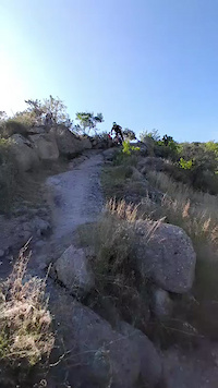
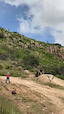
Popular México Mountain Biking Trails
• 100 ★ 3.9 • 4 miles • 39 ft • 1,486 •
Beautiful beginner level trail winding through a cardon forest. Watch for the plant identification signs. Please, no Strava segments on this trail as there are lots of hikers. Slow has right of way on .
• 100 ★ 4.7 • 3,458 ft • 0 ft • 1,246 •
Flow singletrack with some artificial and natural jumps. Very fast with off-camber turns.
• 95 ★ 4.5 • 1,562 ft • 0 ft • 1,085 •
Short piece of singletrack with berms. Un singletrack corto con algunos peraltes.
• 100 ★ 4.4 • 2 miles • 7 ft • 901 •
is a one way trail designed to return riders towards town to avoid conflicts, This trail is a green rated trail often used by runners and walkers. On average it takes about 10 minutes to complete this trail.
• 100 ★ 4.8 • 4,134 ft • 18 ft • 869 •
Trail de fácil acceso, para cualquier nivel ya que pude hacer muy lento o muy divertido y rápido para ciclistas mas avanzados. Primer trail creado con las aportaciones voluntarias de la comunidad ciclista del desierto en colaboración...
• 100 ★ 4.9 • 3,212 ft • 0 ft • 833 •
Trail con un flow . Construido gracias a las donaciones de la Comunidad Ciclista del Desierto en colaboración con Pro Bosque A.C.
• 90 ★ 4.3 • 1,883 ft • 0 ft • 798 •
Bajada muy divertida con dificultad intermedia. Cuenta con un puente empinado, secciones de piedras y curvas.
México Mountain Bike Routes
★ 5.0 • 31 miles • 782 ft • 2 • Point to Point •
Esta ruta comienza en Parres por camino ancho y plano. Encontramos bajadas poco antes de llegar a las...
★ 5.0 • 15 miles • 3,275 ft • 8 • Point to Point •
Una subida muy pesada por camino ancho, bajadas técnicas single track , enlaces con subidas duras y más...
★ 4.5 • 7 miles • 184 ft • 3 •
The 2022 Sportvision mountain bike race will include the and trails.
★ 5.0 • 18 miles • 3,547 ft • 9 • Loop •
This route shows the extend of the trail system (~19 miles - 3700ft elevation), without riding the same...
★ 5.0 • 7 miles • 1,327 ft • 4 • Loop •
La ruta empieza en la Pluma, sube por Barandales hasta Medio y baja por Puntp Rojo, y F1
★ 5.0 • 14 miles • 3,189 ft • 4 • Loop •
La primera parte es subida por camino ancho hasta casi llegar a la explanada del San Miguel, después te...
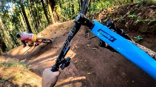
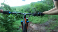
Photos of México Mountain Bike
Videos of México Mountain Bike

featured
![BIGGER IS ALWAYS BETTER -- Mountain Biking No...]()
17:41 |
230 |
Jan 1, 2025
featured
![Parque Ejidal San Nicolas Totolapan en La...]()
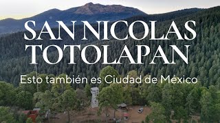
33:33 |
263 |
Jul 24, 2024
trail: Trinidad
0:09 |
6 |
May 1, 2026
trail: Death Wish
0:17 |
8 |
Nov 26, 2025
trail: NDM Meriyein
0:09 |
11 |
Oct 20, 2025
trail: Babel
0:11 |
5 |
Sep 14, 2025
trail: Anarky
0:10 |
10 |
Sep 14, 2025
Recent Comments
| username | type | title | comment | date |
|---|---|---|---|---|
| trail | Rode today. Not closed | Apr 19, 2026 @ 3:45pm Apr 19, 2026 | ||
| trail | Rode today. Downhill is pretty bad but just... | Apr 19, 2026 @ 2:32pm Apr 19, 2026 | ||
| trail | No hay nadie. Abandonado. Nos tocaron vecinos... | Apr 18, 2026 @ 9:12am Apr 18, 2026 | ||
| trail | Apr16 entrance to lower Los topes now has a... | Apr 17, 2026 @ 8:06am Apr 17, 2026 | ||
| report | Trail is closed due to construction and will... | Apr 14, 2026 @ 5:12pm Apr 14, 2026 |
Bike & Skill Parks
| name | type | city | rating |
|---|---|---|---|
| Parque Ejidal San Nicolás Totolapan | bike park | San Nicolás Totolapan | |
| Punta Venado Bike Park | bike park | Playa Del Carmen | |
| Chiluca - El Moño | bike park | Santa Ana Jilotzingo | |
| La Fragua Bike Park | bike park | Guanajuato | |
| Parque Barrancas Trail Network | bike park | San Rafael |
Activity Type Stats
| activitytype | trails | distance | descent | descent distance | total vertical | rating | global rank | state rank | photos | reports | routes | ridelogs |
|---|---|---|---|---|---|---|---|---|---|---|---|---|
| Mountain Bike | 3,003 | 4,049 miles | 984,787 ft | 2,018 miles | 14,429 ft | #17 | 5,975 | 12,806 | 387 | 432,668 | ||
| E-Bike | 2,072 | 2,649 miles | 582,339 ft | 1,264 miles | 13,652 ft | #19 | 66 | 12,076 | 128 | 29,195 | ||
| Gravel Bike | 219 | 373 miles | 44,006 ft | 131 miles | 13,937 ft | #16 | 1,643 | 30 | 1,357 | |||
| Adaptive Bike | 395 | 679 miles | 86,873 ft | 257 miles | 13,625 ft | #16 | 1,717 | 5 | 52 | |||
| Winter Fat Bike | 219 | 244 miles | 49,029 ft | 119 miles | 14,055 ft | #18 | 632 | 13 | ||||
| Horse | 304 | 566 miles | 105,374 ft | 265 miles | 12,979 ft | #21 | 1,482 | 5 | 38 | |||
| Hike | 2,410 | 3,289 miles | 770,131 ft | 1,579 miles | 18,376 ft | #20 | 161 | 12,363 | 50 | 23,492 | ||
| Trail Running | 2,385 | 3,274 miles | 756,175 ft | 1,569 miles | 18,376 ft | #19 | 38 | 12,357 | 60 | 9,079 | ||
| Dirtbike/Moto | 162 | 343 miles | 45,243 ft | 140 miles | 12,497 ft | #23 | 4 | 1,087 | 6 | 322 | ||
| Observed Trials | 34 | 51 miles | 12,224 ft | 24 miles | 12,972 ft | #27 | 10 | 4 | 75 | |||
| ATV/ORV/OHV | 96 | 199 miles | 18,100 ft | 69 miles | 11,959 ft | #18 | 1,073 | 3 | 358 | |||
| Snowmobile | 3 | 2 miles | 1,765 ft | 2 miles | 1,972 ft | #21 | 67 | |||||
| Snowshoe | 3 | 2 miles | 1,765 ft | 2 miles | 1,972 ft | #34 | 14 | |||||
| Downhill Ski | 3 | 2 miles | 1,765 ft | 2 miles | 1,972 ft | #33 | 76 | |||||
| Backcountry Ski | 3 | 2 miles | 1,765 ft | 2 miles | 1,972 ft | #35 | 34 | |||||
| Nordic Ski | 9 | 7 miles | 2,231 ft | 4 miles | 7,136 ft | #32 | 77 |
Activities
- México Mountain Biking Trails
- México E-Biking Trails
- México Gravel Biking Trails
- México Adaptive Biking Trails
- México Winter Fat Biking Trails
- México Horseback Trails
- México Hiking Trails
- México Trail Running Trails
- México Dirtbiking Trails
- México Observed Trials Trails
- México ATVing/Offroading Trails
- México Nordic Skiing Trails
Trails
Points of Interest
- Rockpool TTF
- Mesa Garrison TTF
- Final De Espinazo TTF
- Jackson TTF
- Segundo Drop Toboganes TTF
- Mirador Barranco De Geotermica Viewpoint
- Mirador Geotérmica Viewpoint
- Descolgón Campeón Del Mundo TTF
- Casa Abandonada Viewpoint
- Tobo Drop TTF
- Pecho Iztaccíhuatl (Cumbre) (16,985 ft)
- Iztaccíhuatl (16,985 ft)
- Peña Ordoñez (16,703 ft)
- By canadaka
 Trailforks & contributors
 - Admins: MAG
- #3146 - 58,438 views
- méxico activity log | embed map of México mountain bike trails | méxico mountain biking points of interest polygons
Downloading of trail gps tracks in kml & gpx formats is enabled for México.
You must login to download files.