close
-
Layers w
- Weather Layers
- Pro
- Pro
- Pro
- Pro
- Pro
- Pro
- More Layers
- Pro
- Pro
- Pro
- Pro
-
Upgrade to

3D
Trail Conditions
- Unknown
- Snow Groomed
- Snow Packed
- Snow Covered
- Snow Cover Partial
- Freeze/thaw Cycle
- Icy
- Prevalent Mud
- Wet
- Variable
- Ideal
- Dry
- Very Dry
Trail Flow (Ridden Direction)
Trailforks scans users ridelogs to determine the most popular direction each trail is ridden. A good flowing trail network will have most trails flowing in a single direction according to their intension.
The colour categories are based on what percentage of riders are riding a trail in its intended direction.
The colour categories are based on what percentage of riders are riding a trail in its intended direction.
- > 96%
- > 90%
- > 80%
- > 70%
- > 50%
- < 50%
- bi-directional trail
- no data
Trail Last Ridden
Trailforks scans ridelogs to determine the last time a trail was ridden.
- < 2 days
- < 1 week
- < 2 weeks
- < 1 month
- < 6 months
- > 6 months
Trail Ridden Direction
The intended direction a trail should be ridden.
- Downhill Only
- Downhill Primary
- Both Directions
- Uphill Primary
- Uphill Only
- One Direction
Contribute Details
Colors indicate trail is missing specified detail.
- Description
- Photos
- Description & Photos
- Videos
Trail Popularity ?
Trailforks scans ridelogs to determine which trails are ridden the most in the last 9 months.
Trails are compared with nearby trails in the same city region with a possible 25 colour shades.
Think of this as a heatmap, more rides = more kinetic energy = warmer colors.
- most popular
- popular
- less popular
- not popular
ATV/ORV/OHV Filter
Max Vehicle Width
inches
US Cell Coverage
Legend

Radar Time
Activity Recordings
Trailforks uses anonymized public activity data.
?
Activity Recordings
Trailforks uses anonymized public activity data.
?
Personal Heatmap
▶
Activity Types
all
/
none
▶
Options
2
Date range
month
–
Winter Trails
Warning
A routing network for winter maps does not exist. Selecting trails using the winter trails layer has been disabled.
Missing Trails
Most Popular
Least Popular
Trails are colored based on popularity. The more popular a trail is, the more red. Less popular trails trend towards green.
Jump Magnitude Heatmap
Heatmap of where riders jump on trails. Zoom in to see individual jumps, click circles to view jump details.
BC Backroad Status
![map legend]()
Service Road Atlas is a free to use, community-driven service for viewing and creating reports on the numerous back-country service roads around B.C. and Alberta.

Slope Aspect
Direction the slope faces
Trails Deemphasized
Trails are shown in grey.
Only show trails with no bike usage.
Suggested Layers
Based on selected activity type
Save the current map location and zoom level as your default home location whenever this page is loaded.
SavePopular Trail Networks
view all areas »
No description for Mid Island has been added yet!
Login or register to submit one.
Activities Click to view
- Mountain Bike
1,741 trails
- E-Bike
1,225 trails
- Horse
197 trails
- Hike
1,937 trails
- Trail Running
1,912 trails
- Dirtbike/Moto
347 trails
- Observed Trials
92 trails
- ATV/ORV/OHV
172 trails
- Snowshoe
168 trails
- Downhill Ski
0 trails
- Backcountry Ski
15 trails
- Nordic Ski
4 trails
Stats
- Avg Trail Rating
- Trails (view details)
- 2,146
- Trails Mountain Bike
- 1,755
- Trails E-Bike
- 1,225
- Trails Gravel Bike
- 4
- Trails Horse
- 197
- Trails Hike
- 1,937
- Trails Trail Running
- 1,912
- Trails Dirtbike/Moto
- 347
- Trails Observed Trials
- 92
- Trails ATV/ORV/OHV
- 172
- Trails Snowshoe
- 168
- Trails Backcountry Ski
- 15
- Trails Nordic Ski
- 4
- Total Distance
- 1,298 miles
- Total Descent
- 209,173 ft
- Total Vertical
- 5,948 ft
- Highest Trailhead
- 5,949 ft
- Reports
- 33,528
- Photos
- 7,044
- Ridden Counter
- 527,155
Articles
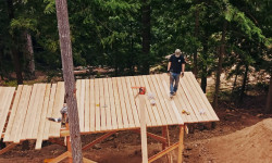
Video: Reece Wallace Mills Lumber to Build a New Freeride Feature From Scratch
Jun 1, 2026 from pinkbike.com
After an island storm knocked down raw fir on his property, Reece Wallace fired up the sawmill to build a massive new feature for the RW Invitational.
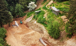
RW Invitational Returns: 100% of Ticket Proceeds Go Directly to the Athletes
May 14, 2026 from pinkbike.com
Reece Wallace brings the freeride community back to his Nanaimo backyard for a high-stakes Whip-Off and Best Trick showdown this July.
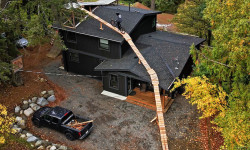
Video: Reece Wallace E-Bikes Up & Off His House
Nov 27, 2025 from pinkbike.com
Those darn e-bikers out there causing a ruckus again...
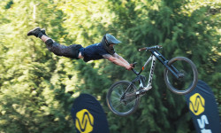
Video: RW Invitational Official Highlights
Sep 4, 2025 from pinkbike.com
All the wild action from the third annual backyard jam.
Sub Regions
- Bowser (58)
- Coombs (3)
- Gabriola Island (40)
- 707 Community Park (24)
- Hesquiant (0)
- Lantzville (132)
- Copley Ridge Forest (64)
- The Foothills Park (60)
- Nanaimo (686)
- Diver Lake (8)
- Doumont (168)
- Hemer Provincial Park (5)
- Linley Valley (68)
- Newcastle Island Marine Provincal Park (8)
- North Benson / Jameson (12)
- Ridge Runner (113)
- South Benson / Wolf Mountain (78)
- South Wellington (47)
- The Abyss / Extension Ridge (89)
- The Bay (2)
- Water District Lands (19)
- Westwood (71)
- Nanoose Bay (227)
- Northwest Bay Trails (161)
- Notch Hill (1)
- Parksville (203)
- Port Alberni (161)
- Alberni Valley Community Forest (0)
- Burde Trails (1)
- Coombs Candy (70)
- MaquinnaTrails (49)
- Sproat Lake (27)
- Stamp River Provincal Park (1)
- Port Renfrew (0)
- Qualicum Beach (216)
- Ucluelet (19)
- Cortes Island (18)
Popular Mid Island Mountain Biking Trails
• 95 ★ 4.5 • 2,890 ft • 0 ft • 2,679 •
Strap in kids cuz... There's the right way, the wrong way, AND the way!!! Isn't that the wrong way? Yes! But FASTER!
• 100 ★ 4.6 • 4,718 ft • 0 ft • 2,618 •
Ned approved, this trail will have you exclaiming, "Feels like I'm wearing nothing at all!"
• 100 ★ 4.0 • 2,779 ft • 10 ft • 2,600 •
, also known as the pump track or flow trail, is the first prov ially approved trail built by the NMBC. The trail is on a piece of Crown land in the Doumont trail network. Approval and construction of the trail would not have been...
• 100 ★ 4.4 • 1,017 ft • 0 ft • 2,576 •
This is the most blatant case of false advertising since my suit against the movie The Neverending Story.
• 100 ★ 3.9 • 2,467 ft • 0 ft • 2,504 •
Combine this with to start an easy climb to other lower HammerFest trails. The last section in the whole trail network.
• 100 ★ 3.7 • 1,342 ft • 151 ft • 2,257 •
Moderate singletrack climbing trail to get the uphill traffic off of .
• 100 ★ 4.0 • 3,724 ft • 3 ft • 2,205 •
Machine built downhill pumptrack. This trail is a must ride! Built in 2017-8 for the Nanaimo Mountain Bike Club with funding from the Nanaimo Hospitality Association and Tourism Nanaimo along with Generous donations from FMI, Sharecost...
Mid Island Mountain Bike Routes
Ridge Runner Tour Featured
16 miles • 1,737 ft • 68 • Loop •
★ 3.7 • 23 miles • 3,114 ft • 17 •
BCBR 2025 Stage 4 Nanaimo. An XC heavy, steady load day in the amazing and varied landscapes of Nanaimo
★ 4.5 • 5 miles • 880 ft • 14 • Loop •
Pretty much a bit of everything in this loop. Located primarily in the lower portions of HammerFest so...
★ 4.0 • 23 miles • 2,916 ft • 19 •
Stage 6 BCBR: A mix of riding styles; distinct terrain, Big Bang Cidery to finish!
★ 5.0 • 22 miles • 3,391 ft • 16 •
Four distinct zones, very pedalable with a few very hard climbs. Some ripper downs. Well built, modern...
Photos of Mid Island Mountain Bike
Videos of Mid Island Mountain Bike
trail: RIP 67
2:19 |
56 |
Apr 14, 2025
trail: Blitzkreek
4:39 |
64 |
Apr 14, 2025
trail: (Space) Bound Hound
0:18 |
296 |
Dec 8, 2024
trail: Space
0:13 |
332 |
Dec 8, 2024
trail: (Space) Bound Hound
0:12 |
307 |
Nov 15, 2024
trail: (Space) Kitty
0:13 |
406 |
Nov 8, 2024
trail: Teleglobe Trail
0:09 |
21 |
Jan 28, 2024
trail: China Creek Trail
0:12 |
27 |
Jan 28, 2024
Current Trail Warnings
| status | trail | date | condition | user | info |
|---|---|---|---|---|---|
| Uterbraten South Benson / Wolf Mountain | Jun 19, 2026 @ 9:54am (America/Vancouver) 1 day | Unknown | kebble | ||
| Insurrection HammerFest | Jun 14, 2026 @ 12:37pm (America/Vancouver) Jun 14, 2026 | Unknown | adfam ACC | ||
| Free Fall HammerFest | Jun 14, 2026 @ 12:31pm (America/Vancouver) Jun 14, 2026 | Unknown | adfam ACC | Sign up closed for logging about half way... |
Recent Trail Reports
Activity Feed
| username | action | type | title | date |
|---|---|---|---|---|
| alduff9 | ridden | trail | activity #97425795 | Jun 20, 2026 @ 1:01pm 3 hours |
| jpsalley | vote | trail | activity #97400035 | Jun 20, 2026 @ 8:44am 7 hours |
| gUBIx0 | wishlist | trail | activity #97366910 | Jun 19, 2026 @ 10:25pm 17 hours |
| DMal | wishlist | route | activity #97355891 | Jun 19, 2026 @ 5:27pm 22 hours |
| allisonbcjjpI | wishlist | route | activity #97346654 | Jun 19, 2026 @ 2:57pm 1 day |
Recent Comments
| username | type | title | comment | date |
|---|---|---|---|---|
| trail | lol I ride this backwards on a single speed.... | Jun 19, 2026 @ 10:59am 1 day | ||
| report | Nice, ok didn’t see the pix. I will... | Jun 19, 2026 @ 9:51am 1 day | ||
| report | Uhhh what does? On gooseshit? | Jun 19, 2026 @ 9:50am 1 day | ||
| report | Looks awesome! | Jun 18, 2026 @ 6:54pm 2 days | ||
| report | Wondering rationale for the reroute and... | Jun 16, 2026 @ 10:11am Jun 16, 2026 |
Local Badges
-

Completionist0 awarded -
Completionist1 awarded -
Completionist16 awarded -
Completionist18 awarded -
Completionist6 awarded -
Completionist0 awarded
Bike & Skill Parks
| name | type | city | rating |
|---|---|---|---|
| Cougar Smith Bike Skills Park | skill park | Port Alberni | |
| Stevie Smith Memorial Park | skill park | Nanaimo | |
| Lions Bike Park | skill park | Bowser | |
| Erik Goetzinger BMX Park | skill park | Qualicum Beach | |
| Nanaimo BMX | skill park | Nanaimo |
Local Trail Supporters
- Jacques Brassard
![]()
- mar kus
- kus
![]()
- Bud
![Mount Arrowsmith Brewing Company]()
![]()
- AP Construction
- Roy Kregosky
![]()
- mikeLucie
Local Trail Association
Activity Type Stats
| activitytype | trails | distance | descent | descent distance | total vertical | rating | global rank | state rank | photos | reports | routes | ridelogs |
|---|---|---|---|---|---|---|---|---|---|---|---|---|
| Mountain Bike | 1,741 | 878 miles | 134,406 ft | 363 miles | 3,599 ft | 6,665 | 33,455 | 168 | 261,987 | |||
| E-Bike | 1,225 | 594 miles | 83,465 ft | 243 miles | 3,455 ft | 66 | 29,600 | 37 | 16,036 | |||
| Gravel Bike | 4 | 5 | 85 | 5 | 1,466 | |||||||
| Horse | 197 | 104 miles | 9,160 ft | 42 miles | 2,746 ft | 5,546 | 1 | 143 | ||||
| Hike | 1,937 | 1,174 miles | 182,713 ft | 459 miles | 5,948 ft | 302 | 32,675 | 14 | 33,505 | |||
| Trail Running | 1,912 | 1,152 miles | 177,848 ft | 452 miles | 5,948 ft | 33 | 32,633 | 17 | 33,892 | |||
| Dirtbike/Moto | 347 | 235 miles | 26,686 ft | 91 miles | 3,241 ft | 70 | 5,687 | 3 | 2,828 | |||
| Observed Trials | 92 | 67 miles | 7,687 ft | 24 miles | 3,192 ft | 52 | 131 | |||||
| ATV/ORV/OHV | 172 | 144 miles | 15,761 ft | 56 miles | 3,238 ft | 6 | 5,431 | 1 | 344 | |||
| Snowshoe | 168 | 93 miles | 13,301 ft | 37 miles | 5,030 ft | 125 | 87 | |||||
| Backcountry Ski | 15 | 44 miles | 8,848 ft | 18 miles | 4,826 ft | 1 | 186 | |||||
| Nordic Ski | 4 | 4 miles | 591 ft | 3 miles | 3,684 ft | 2 | 16 | 105 |
Frequently Asked Questions About Mid Island
▼
What are the best places to ride in Mid Island?
Mid Island has 61 areas to explore for mountain biking. The top rated areas are:
▼
What are the highest rated mountain biking trails in Mid Island?
The highest rated mountain biking trails in Mid Island are:
- Lower DH (4.6/5)
- Tomcat (4.6/5)
- Bear Necessities (4.6/5)
- Sexy Flanders (4.6/5)
- Mattmo (4.5/5)
▼
What is the best time of the year to ride in Mid Island?
Based on ride log data, the most popular months to ride in Mid Island are:
- July (4,568 activities)
- May (3,788 activities)
- August (3,775 activities)
▼
What is the longest trail in Mid Island?
The longest trail in Mid Island is Big Qualicum Trail at 6.1 miles. View all trails sorted by distance.
Activities
- Mid Island Mountain Biking Trails
- Mid Island E-Biking Trails
- Mid Island Horseback Trails
- Mid Island Hiking Trails
- Mid Island Trail Running Trails
- Mid Island Dirtbiking Trails
- Mid Island Observed Trials Trails
- Mid Island ATVing/Offroading Trails
- Mid Island Snowshoeing Trails
- Mid Island Backcountry Skiing Trails
Trails
Points of Interest
- Klanawa River Camp Camping
- Darling River Camp Camping
- Tsocowis Creek Camp Camping
- Pachena Bay Campground Camping
- Pachena Point Lighthouse Sight
- Bonilla Creek Campsite Camping
- Cullite Creek Campsite Camping
- Mount Porter Summit
- Pogo Mountain Summit
- Steamboat Mountain Summit
- Mount Bute (9,190 ft)
- Gunsight Peak (8,796 ft)
- Tahumming Mountain (8,258 ft)
- By canadaka
 Trailforks & contributors
 - Admins: BCBR, TrailsBC, BCORMA, DSBC, wheelmaniac3, bcpunk
- #3035 - 13,280 views
- mid island activity log | embed map of Mid Island mountain bike trails | mid island mountain biking points of interest polygons
Downloading of trail gps tracks in kml & gpx formats is enabled for Mid Island.
You must login to download files.