close
-
Layers w
- Weather Layers
- Pro
- Pro
- Pro
- Pro
- Pro
- Pro
- More Layers
- Pro
- Pro
- Pro
- Pro
-
Upgrade to

3D
Trail Conditions
- Unknown
- Snow Groomed
- Snow Packed
- Snow Covered
- Snow Cover Partial
- Freeze/thaw Cycle
- Icy
- Prevalent Mud
- Wet
- Variable
- Ideal
- Dry
- Very Dry
Trail Flow (Ridden Direction)
Trailforks scans users ridelogs to determine the most popular direction each trail is ridden. A good flowing trail network will have most trails flowing in a single direction according to their intension.
The colour categories are based on what percentage of riders are riding a trail in its intended direction.
The colour categories are based on what percentage of riders are riding a trail in its intended direction.
- > 96%
- > 90%
- > 80%
- > 70%
- > 50%
- < 50%
- bi-directional trail
- no data
Trail Last Ridden
Trailforks scans ridelogs to determine the last time a trail was ridden.
- < 2 days
- < 1 week
- < 2 weeks
- < 1 month
- < 6 months
- > 6 months
Trail Ridden Direction
The intended direction a trail should be ridden.
- Downhill Only
- Downhill Primary
- Both Directions
- Uphill Primary
- Uphill Only
- One Direction
Contribute Details
Colors indicate trail is missing specified detail.
- Description
- Photos
- Description & Photos
- Videos
Trail Popularity ?
Trailforks scans ridelogs to determine which trails are ridden the most in the last 9 months.
Trails are compared with nearby trails in the same city region with a possible 25 colour shades.
Think of this as a heatmap, more rides = more kinetic energy = warmer colors.
- most popular
- popular
- less popular
- not popular
ATV/ORV/OHV Filter
Max Vehicle Width
inches
US Cell Coverage
Legend

Radar Time
Activity Recordings
Trailforks uses anonymized public activity data.
?
Activity Recordings
Trailforks uses anonymized public activity data.
?
Personal Heatmap
▶
Activity Types
all
/
none
▶
Options
2
Date range
month
–
Winter Trails
Warning
A routing network for winter maps does not exist. Selecting trails using the winter trails layer has been disabled.
Missing Trails
Most Popular
Least Popular
Trails are colored based on popularity. The more popular a trail is, the more red. Less popular trails trend towards green.
Jump Magnitude Heatmap
Heatmap of where riders jump on trails. Zoom in to see individual jumps, click circles to view jump details.
BC Backroad Status
![map legend]()
Service Road Atlas is a free to use, community-driven service for viewing and creating reports on the numerous back-country service roads around B.C. and Alberta.

Slope Aspect
Direction the slope faces
Trails Deemphasized
Trails are shown in grey.
Only show trails with no bike usage.
Suggested Layers
Based on selected activity type
Save the current map location and zoom level as your default home location whenever this page is loaded.
SaveMountain Bike and Hiking Trails centered around McNeill Lake and accessible via the Middlepoint and McNeill Lake Forest Service Roads
Activities Click to view
- Mountain Bike
51 trails
- E-Bike
48 trails
- Hike
54 trails
- Trail Running
52 trails
- Dirtbike/Moto
11 trails
- Observed Trials
8 trails
- ATV/ORV/OHV
6 trails
Region Details
- 20
- 14
- 12
- 5
Region Status
Caution as of Mar 5, 2026Stats
- Avg Trail Rating
- Trails (view details)
- 53
- Trails Mountain Bike
- 51
- Trails E-Bike
- 48
- Trails Horse
- 2
- Trails Hike
- 54
- Trails Trail Running
- 52
- Trails Dirtbike/Moto
- 11
- Trails Observed Trials
- 8
- Trails ATV/ORV/OHV
- 6
- Total Distance
- 44 miles
- Total Descent
- 7,317 ft
- Total Vertical
- 2,288 ft
- Highest Trailhead
- 2,379 ft
- Reports
- 204
- Photos
- 89
- Ridden Counter
- 4,194
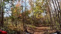
Popular MiddlePoint Mountain Biking Trails
• 85 ★ 4.0 • 1,637 ft • 0 ft • 351 •
Popular blue difficulty singletrack. This mountain bike primary trail can be used both directions with a 0 ft blue climb. On average it takes 4 minutes to complete this trail.
• 85 ★ 4.0 • 5,070 ft • 44 ft • 295 •
Part of the B.C. Bike Race Route. Gives you the option of staying high and joining the west sechelt trails (cabin fever and deliverance) instead of going down to Secret Cove (food!) and Half Moon Bay.
• 100 ★ 4.0 • 5,212 ft • 189 ft • 234 •
Popular green difficulty mixed. This mountain bike primary trail can be used both directions. On average it takes 7 minutes to complete this trail.
• 95 ★ 5.0 • 4,082 ft • 116 ft • 174 •
Great cross country lap through a low lying area. Some larger wet spots after a rain.
• 70 ★ 4.0 • 800 ft • 3 ft • 116 •
One short steep hill. Can be overgrown. Combine with
• 80 ★ 0.0 • 5 miles • 884 ft • 95 •
Beautiful double track built by Andy Curtiss and funded by the SCRD. Ends at the Homesite Creek where you can jump on the highway to Halfmoon Bay or jig north to try out the campsite, Cabin Fever, and Deliverance linking you to the...
Photos of MiddlePoint Mountain Bike
Videos of MiddlePoint Mountain Bike
trail: Nobody Was His Name
0:46 |
113 |
Nov 1, 2017

trail: Close Your Eyes
3:33 |
702 |
Jan 23, 2015
trail: FSR
0:55 |
317 |
Jan 5, 2014
trail: FSR
0:38 |
1126 |
Aug 22, 2012
Recent Trail Reports
| status | trail | date | condition | info | user |
|---|---|---|---|---|---|
| Middlepoint Homesite Connector | Mar 5, 2026 @ 1:02pm (America/Vancouver) Mar 5, 2026 | Variable | 421coast | ||
| Pender Mudders Society | Nov 15, 2025 @ 12:48pm (America/Vancouver) Nov 15, 2025 | Variable | 421coast | ||
| Cougars | Aug 18, 2025 @ 11:25am Aug 18, 2025 | Ideal | sakinaw | ||
| Elk Trail | Aug 18, 2025 @ 11:25am Aug 18, 2025 | Ideal | sakinaw | ||
| Old Pole Road | Aug 18, 2025 @ 11:25am Aug 18, 2025 | Ideal | sakinaw | ||
| Copper Head | Aug 18, 2025 @ 11:25am Aug 18, 2025 | Ideal | sakinaw | ||
| Lucy's Loop | Aug 18, 2025 @ 11:25am Aug 18, 2025 | Ideal | sakinaw | ||
| Nobody Was His Name | Aug 18, 2025 @ 11:25am Aug 18, 2025 | Ideal | sakinaw | ||
| Lazy Boy | Aug 18, 2025 @ 11:25am Aug 18, 2025 | Ideal | sakinaw | ||
| Roller Coaster | Jul 10, 2025 @ 1:59pm Jul 10, 2025 | Dry | 421coast |
Activity Feed
| username | action | type | title | date |
|---|---|---|---|---|
| shellbobell | add | photo | activity #92515819 | Apr 12, 2026 @ 5:51pm Apr 12, 2026 |
| 421coast | add | report | activity #90036961 | Mar 5, 2026 @ 4:34pm Mar 5, 2026 |
| AmandaaoIhKY | ridden | trail | activity #87264550 | Jan 15, 2026 @ 7:18pm Jan 15, 2026 |
| 421coast | add | report | activity #84254677 | Nov 16, 2025 @ 9:57am Nov 16, 2025 |
| mattmalabanan | update | trail | activity #83720226 and 1 more | Nov 7, 2025 @ 7:25am Nov 7, 2025 |
Recent Comments
| username | type | title | comment | date |
|---|---|---|---|---|
| trail | Not recommended! Overgrown, lots of loose... | Jul 23, 2025 @ 10:14pm Jul 23, 2025 | ||
| trail | If you are looking to traverse the Sunshine... | Jul 10, 2025 @ 7:03pm Jul 10, 2025 | ||
| trail | Beautiful section of trail! | Jun 30, 2025 @ 1:09pm Jun 30, 2025 | ||
| trail | Gorgeous double track through a nice section... | Jun 30, 2025 @ 1:08pm Jun 30, 2025 | ||
| trail | Wayfinding difficult without a gps. "Trail" is... | Jun 30, 2025 @ 1:07pm Jun 30, 2025 |
Nearby Areas
| name | distance | ||||
|---|---|---|---|---|---|
| Kleindale | 17 | 15 | 1 | 5.1 km | |
| Halfmoon Bay | 10 | 36 | 2 | 6 km | |
| Nelson Island | 6.1 km | ||||
| Connor Park | 13 | 11 | 7.4 km | ||
| West Sechelt | 19 | 58 | 45 | 3 | 7.4 km |
Local Badges
-

Completionist0 awarded
Activity Type Stats
| activitytype | trails | distance | descent | descent distance | total vertical | rating | global rank | state rank | photos | reports | routes | ridelogs |
|---|---|---|---|---|---|---|---|---|---|---|---|---|
| Mountain Bike | 51 | 43 miles | 7,221 ft | 20 miles | 2,290 ft | #3,726 | #167 | 73 | 200 | 782 | ||
| E-Bike | 48 | 42 miles | 7,182 ft | 20 miles | 2,290 ft | #3,051 | #107 | 7 | 201 | 59 | ||
| Horse | 2 | 2 miles | 138 ft | 3,278 ft | 302 ft | 15 | ||||||
| Hike | 54 | 44 miles | 7,316 ft | 20 miles | 2,290 ft | #736 | #50 | 6 | 204 | 261 | ||
| Trail Running | 52 | 43 miles | 7,221 ft | 20 miles | 2,290 ft | #4,007 | #128 | 204 | 28 | |||
| Dirtbike/Moto | 11 | 15 miles | 1,594 ft | 7 miles | 974 ft | #829 | #71 | 18 | 37 | |||
| Observed Trials | 8 | 13 miles | 1,355 ft | 6 miles | 974 ft | #221 | #39 | 3 | ||||
| ATV/ORV/OHV | 6 | 10 miles | 1,260 ft | 5 miles | 820 ft | #587 | #53 | 3 | 17 | 9 |
Frequently Asked Questions About MiddlePoint
▼
What are the highest rated mountain biking trails in MiddlePoint?
The highest rated mountain biking trails in MiddlePoint are:
- Old Pole Road (4.2/5)
- Endor (4.1/5)
- Rufus's Run (4.1/5)
- Copper Head (4.1/5)
- Roller Coaster (4/5)
▼
What is the best time of the year to ride in MiddlePoint?
Based on ride log data, the most popular months to ride in MiddlePoint are:
- August (39 activities)
- July (29 activities)
- October (17 activities)
▼
Where can I park to ride in MiddlePoint?
Check the MiddlePoint trail map for trailhead and parking information. Community members regularly update access and parking details for trails in the area.
▼
What is the longest trail in MiddlePoint?
The longest trail in MiddlePoint is Middlepoint to Halfmoon Bay Sunshine coast trail at 4.7 miles. View all trails sorted by distance.
Activities
- By FredFishface & contributors
- Admins: CMBTA, SCDBA
- #15136 - 3,907 views
- middlepoint activity log | embed map of MiddlePoint mountain bike trails |
Downloading of trail gps tracks in kml & gpx formats is enabled for MiddlePoint.
You must login to download files.