close
-
Layers w
- Weather Layers
- Pro
- Pro
- Pro
- Pro
- Pro
- Pro
- More Layers
- Pro
- Pro
- Pro
- Pro
-
Upgrade to

3D
Trail Conditions
- Unknown
- Snow Groomed
- Snow Packed
- Snow Covered
- Snow Cover Partial
- Freeze/thaw Cycle
- Icy
- Prevalent Mud
- Wet
- Variable
- Ideal
- Dry
- Very Dry
Trail Flow (Ridden Direction)
Trailforks scans users ridelogs to determine the most popular direction each trail is ridden. A good flowing trail network will have most trails flowing in a single direction according to their intension.
The colour categories are based on what percentage of riders are riding a trail in its intended direction.
The colour categories are based on what percentage of riders are riding a trail in its intended direction.
- > 96%
- > 90%
- > 80%
- > 70%
- > 50%
- < 50%
- bi-directional trail
- no data
Trail Last Ridden
Trailforks scans ridelogs to determine the last time a trail was ridden.
- < 2 days
- < 1 week
- < 2 weeks
- < 1 month
- < 6 months
- > 6 months
Trail Ridden Direction
The intended direction a trail should be ridden.
- Downhill Only
- Downhill Primary
- Both Directions
- Uphill Primary
- Uphill Only
- One Direction
Contribute Details
Colors indicate trail is missing specified detail.
- Description
- Photos
- Description & Photos
- Videos
Trail Popularity ?
Trailforks scans ridelogs to determine which trails are ridden the most in the last 9 months.
Trails are compared with nearby trails in the same city region with a possible 25 colour shades.
Think of this as a heatmap, more rides = more kinetic energy = warmer colors.
- most popular
- popular
- less popular
- not popular
ATV/ORV/OHV Filter
Max Vehicle Width
inches
US Cell Coverage
Legend

Radar Time
Activity Recordings
Trailforks uses anonymized public activity data.
?
Activity Recordings
Trailforks uses anonymized public activity data.
?
Personal Heatmap
▶
Activity Types
all
/
none
▶
Options
2
Date range
month
–
Winter Trails
Warning
A routing network for winter maps does not exist. Selecting trails using the winter trails layer has been disabled.
Missing Trails
Most Popular
Least Popular
Trails are colored based on popularity. The more popular a trail is, the more red. Less popular trails trend towards green.
Jump Magnitude Heatmap
Heatmap of where riders jump on trails. Zoom in to see individual jumps, click circles to view jump details.
BC Backroad Status
![map legend]()
Service Road Atlas is a free to use, community-driven service for viewing and creating reports on the numerous back-country service roads around B.C. and Alberta.

Slope Aspect
Direction the slope faces
Trails Deemphasized
Trails are shown in grey.
Only show trails with no bike usage.
Suggested Layers
Based on selected activity type
Save the current map location and zoom level as your default home location whenever this page is loaded.
Save
No description for Miglieglia has been added yet!
Login or register to submit one.
This region uses the Uk/Euro style trail grading system.
Activities Click to view
- Mountain Bike
24 trails
- E-Bike
23 trails
- Gravel Bike
1 trails
- Hike
23 trails
- Trail Running
23 trails
Region Details
- 3
- 2
- 15
- 2
- 1
Region Status
Open as of Jun 14, 2026Stats
- Avg Trail Rating
- Trails (view details)
- 24
- Trails Mountain Bike
- 24
- Trails E-Bike
- 23
- Trails Gravel Bike
- 1
- Trails Hike
- 23
- Trails Trail Running
- 23
- Total Distance
- 18 miles
- Total Descent Distance
- 13 miles
- Total Descent
- 10,298 ft
- Total Vertical
- 3,123 ft
- Highest Trailhead
- 5,351 ft
- Reports
- 148
- Photos
- 14
- Ridden Counter
- 1,823
Sub Regions
-
Monte Lema
- 2
- 12
- 1
- 1
Popular Miglieglia Mountain Biking Trails
• 5 ★ 3.6 • 5,098 ft • 60 ft • 151 •
Less popular blue difficulty alpine machine groomed. This multi-use trail can be used downhill primary. Trail visibility is always easy to follow. On average it takes 17 minutes to complete this trail.
• 100 ★ 3.8 • 1,175 ft • 0 ft • 85 •
Popular blue difficulty machine groomed. This mountain bike primary trail can be used downhill only. Trail visibility is always easy to follow.
• 75 ★ 3.5 • 2,241 ft • 0 ft • 75 •
Popular green difficulty singletrack. This multi-use trail can be used downhill primary. On average it takes 2 minutes to complete this trail.
• 90 ★ 3.9 • 2,421 ft • 0 ft • 71 •
Popular blue difficulty machine groomed. This mountain bike primary trail can be used downhill only. It features berm. Trail visibility is always easy to follow.
• 55 ★ 3.7 • 1 mile • 18 ft • 68 • • hike
Moderately popular blue difficulty alpine singletrack. This hike primary trail can be used downhill only. Trail visibility is always easy to follow. On average it takes 42 minutes to complete this trail.
• 65 ★ 3.5 • 4,810 ft • 0 ft • 62 • • hike
Moderately popular blue difficulty singletrack. This hike primary trail can be used both directions with a 0 ft blue climb. On average it takes 2 minutes to complete this trail.
• 20 ★ 3.5 • 2 miles • 0 ft • 59 • • hike
Less popular black difficulty singletrack. This hike primary trail can be used downhill only. On average it takes 36 minutes to complete this trail.
• 65 ★ 0.0 • 1,972 ft • 20 ft • 44 •
Moderately popular blue difficulty singletrack. This multi-use trail can be used both directions. On average it takes 3 minutes to complete this trail.
Miglieglia Mountain Bike Routes
★ 4.0 • 8 miles • 428 ft • 4 •
Monte Lema, italy, back to swiss, back to Miglieglia
4 miles • 159 ft • 5 • Point to Point •
Monte Lema, , Miglieglia. Spectacular view
4 miles • 73 ft • 2 • Point to Point •
From the top to Miglieglia. Historical route
4 miles • 200 ft • 4 • Point to Point •
From the top of Monte Lema to the start of the cablecar
Videos of Miglieglia Mountain Bike
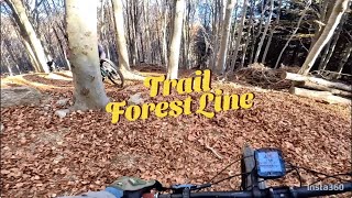
trail: Monte Lema Forest Line
4:03 |
134 |
Nov 18, 2024 , Miglieglia
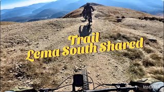
trail: Lema South Shared Trail
8:01 |
162 |
Nov 18, 2024 , Miglieglia
youtuber
![Monte Lema]()
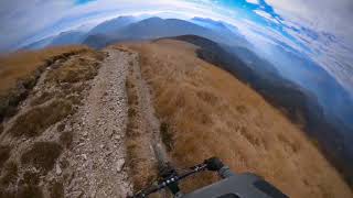
trail: Lema South Shared Trail
0:24 |
906 |
Nov 2, 2020 , Miglieglia
Recent Trail Reports
| status | trail | date | condition | info | user |
|---|---|---|---|---|---|
| A Caruli | Jun 14, 2026 @ 5:59pm (Europe/Zurich) Jun 14, 2026 | Ideal | pit907 | ||
| Via Cantonale | Jun 11, 2026 @ 7:32pm (Europe/Zurich) Jun 11, 2026 | Ideal | pit907 | ||
| Tortoglio | Jun 11, 2026 @ 7:32pm (Europe/Zurich) Jun 11, 2026 | Ideal | pit907 | ||
| Motto di Galbirona | May 31, 2026 @ 6:46am (Pacific/Midway) May 31, 2026 | Dry | adessoomaipiu | ||
| Passo di Monte Faëta | May 31, 2026 @ 6:46am (Pacific/Midway) May 31, 2026 | Ideal | adessoomaipiu | ||
| Monte Lema Forest Line | May 31, 2026 @ 6:46am (Pacific/Midway) May 31, 2026 | Very Dry | adessoomaipiu | ||
| Cima Pianca | May 31, 2026 @ 6:46am (Pacific/Midway) May 31, 2026 | Very Dry | adessoomaipiu | ||
| Lema South MTB Trail | May 31, 2026 @ 6:46am (Pacific/Midway) May 31, 2026 | Very Dry | adessoomaipiu | ||
| Lema South Shared Trail | May 31, 2026 @ 6:46am (Pacific/Midway) May 31, 2026 | Very Dry | adessoomaipiu | ||
| Alpe Arasio | May 31, 2026 @ 6:46am (Pacific/Midway) May 31, 2026 | Ideal | adessoomaipiu |
National Scenic Trails & Official Routes
-
Lugano Bike #66
- Mountain Bike
- E-Bike

Activity Feed
| username | action | type | title | date |
|---|---|---|---|---|
| Leatt1977 | wishlist | route | activity #97164869 | Jun 16, 2026 @ 11:23pm Jun 16, 2026 |
| MarioGasparri | ridden | route | activity #97089934 | Jun 15, 2026 @ 11:26pm Jun 15, 2026 |
| Zigers | ridden | trail | activity #97034728 and 6 more | Jun 15, 2026 @ 5:37am Jun 15, 2026 |
| pit907 | vote | trail | activity #96975056 | Jun 14, 2026 @ 9:00am Jun 14, 2026 |
| pit907 | add | report | activity #96975049 | Jun 14, 2026 @ 8:59am Jun 14, 2026 |
Recent Comments
| username | type | title | comment | date |
|---|---|---|---|---|
| report | Divertente single trail | Apr 25, 2026 @ 10:20am Apr 25, 2026 | ||
| trail | Sentiero per bici con alcune sponde, un drop e... | Apr 10, 2026 @ 10:04am Apr 10, 2026 | ||
| trail | Il sentiero è stato rifatto da un po’ di... | Apr 10, 2026 @ 10:02am Apr 10, 2026 | ||
| trail | Schöner Weg | Jul 29, 2025 @ 3:57am Jul 29, 2025 | ||
| trail | Very nice trail. Very flow. Be careful before... | Jun 11, 2025 @ 8:53am Jun 11, 2025 |
Local Badges
-

Epic Mountain Bike Climb 2k11 awarded -

Climbing 10k Badge0 awarded -

Mountain Biking 100k Badge0 awarded -

Epic Ride Descent 2k11 awarded -

Descent 10k Badge0 awarded -

Descent 100k Badge0 awarded
Activity Type Stats
| activitytype | trails | distance | descent | descent distance | total vertical | rating | global rank | state rank | photos | reports | routes | ridelogs |
|---|---|---|---|---|---|---|---|---|---|---|---|---|
| Mountain Bike | 24 | 17 miles | 9,606 ft | 12 miles | 3,123 ft | #7,731 | #227 | 7 | 148 | 6 | 192 | |
| E-Bike | 23 | 16 miles | 8,225 ft | 11 miles | 3,123 ft | #4,357 | #177 | 141 | 4 | 59 | ||
| Gravel Bike | 1 | #403 | #52 | 7 | 1 | |||||||
| Hike | 23 | 18 miles | 9,764 ft | 12 miles | 3,123 ft | #5,860 | #148 | 144 | 61 | |||
| Trail Running | 23 | 18 miles | 9,764 ft | 12 miles | 3,123 ft | #6,343 | #157 | 144 | 26 |
Frequently Asked Questions About Miglieglia
▼
What are the best places to ride in Miglieglia?
Miglieglia has 1 areas to explore for mountain biking. The top rated areas are:
▼
What are the highest rated mountain biking trails in Miglieglia?
The highest rated mountain biking trails in Miglieglia are:
- A Caruli (4.1/5)
- Motto di Galbirona (4/5)
- Astano - Miglieglia (4/5)
- Monte Lema Forest Line (3.9/5)
- Lema South MTB Trail (3.9/5)
▼
What is the best time of the year to ride in Miglieglia?
Based on ride log data, the most popular months to ride in Miglieglia are:
- November (2 activities)
- August (2 activities)
- October (1 activities)
▼
Where can I park to ride in Miglieglia?
There are 1 parking locations listed in Miglieglia. The most popular parking spots are:
Activities
Trails
Points of Interest
- By Chrigi58 & contributors
- Admins: TIS
- #38325 - 890 views
- miglieglia activity log | embed map of Miglieglia mountain bike trails | miglieglia mountain biking points of interest
Downloading of trail gps tracks in kml & gpx formats is enabled for Miglieglia.
You must login to download files.