close
-
Layers w
- Weather Layers
- Pro
- Pro
- Pro
- Pro
- Pro
- Pro
- More Layers
- Pro
- Pro
- Pro
- Pro
-
Upgrade to

3D
Trail Conditions
- Unknown
- Snow Groomed
- Snow Packed
- Snow Covered
- Snow Cover Partial
- Freeze/thaw Cycle
- Icy
- Prevalent Mud
- Wet
- Variable
- Ideal
- Dry
- Very Dry
Trail Flow (Ridden Direction)
Trailforks scans users ridelogs to determine the most popular direction each trail is ridden. A good flowing trail network will have most trails flowing in a single direction according to their intension.
The colour categories are based on what percentage of riders are riding a trail in its intended direction.
The colour categories are based on what percentage of riders are riding a trail in its intended direction.
- > 96%
- > 90%
- > 80%
- > 70%
- > 50%
- < 50%
- bi-directional trail
- no data
Trail Last Ridden
Trailforks scans ridelogs to determine the last time a trail was ridden.
- < 2 days
- < 1 week
- < 2 weeks
- < 1 month
- < 6 months
- > 6 months
Trail Ridden Direction
The intended direction a trail should be ridden.
- Downhill Only
- Downhill Primary
- Both Directions
- Uphill Primary
- Uphill Only
- One Direction
Contribute Details
Colors indicate trail is missing specified detail.
- Description
- Photos
- Description & Photos
- Videos
Trail Popularity ?
Trailforks scans ridelogs to determine which trails are ridden the most in the last 9 months.
Trails are compared with nearby trails in the same city region with a possible 25 colour shades.
Think of this as a heatmap, more rides = more kinetic energy = warmer colors.
- most popular
- popular
- less popular
- not popular
ATV/ORV/OHV Filter
Max Vehicle Width
inches
US Cell Coverage
Legend

Radar Time
Activity Recordings
Trailforks uses anonymized public activity data.
?
Activity Recordings
Trailforks uses anonymized public activity data.
?
Personal Heatmap
▶
Activity Types
all
/
none
▶
Options
2
Date range
month
–
Winter Trails
Warning
A routing network for winter maps does not exist. Selecting trails using the winter trails layer has been disabled.
Missing Trails
Most Popular
Least Popular
Trails are colored based on popularity. The more popular a trail is, the more red. Less popular trails trend towards green.
Jump Magnitude Heatmap
Heatmap of where riders jump on trails. Zoom in to see individual jumps, click circles to view jump details.
BC Backroad Status
![map legend]()
Service Road Atlas is a free to use, community-driven service for viewing and creating reports on the numerous back-country service roads around B.C. and Alberta.

Slope Aspect
Direction the slope faces
Trails Deemphasized
Trails are shown in grey.
Only show trails with no bike usage.
Suggested Layers
Based on selected activity type
Save the current map location and zoom level as your default home location whenever this page is loaded.
Save
No description for Millau has been added yet!
Login or register to submit one.
This region uses the Uk/Euro style trail grading system.
Activities Click to view
- Mountain Bike
141 trails
- E-Bike
120 trails
- Adaptive Bike
0 trails
- Hike
72 trails
- Trail Running
73 trails
Region Details
- 48
- 12
- 35
- 36
- 6
Region Status
Open as of Apr 8, 2026Stats
- Avg Trail Rating
- Trails (view details)
- 137
- Trails Mountain Bike
- 141
- Trails E-Bike
- 120
- Trails Horse
- 2
- Trails Hike
- 72
- Trails Trail Running
- 73
- Total Distance
- 192 miles
- Total Descent Distance
- 113 miles
- Total Descent
- 69,905 ft
- Total Vertical
- 2,082 ft
- Highest Trailhead
- 3,193 ft
- Reports
- 185
- Photos
- 119
- Ridden Counter
- 4,738
Articles
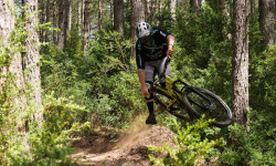
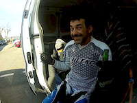
Video: At Home in France with Rudy Cabirou
Jul 26, 2019 from pinkbike.com
Propain Factory Racing rider Rudy Cabirou takes you around his home trails in Millau, France.
Sub Regions
-
Espace VTT Millau Grands Causses
- 12
- 32
- 34
- 5
-
La Puncho
- 1
- 1
-
la roque saint marguerite
- 1
- 2
- 1
Popular Millau Mountain Biking Trails
• 75 ★ 4.0 • 2 miles • 16 ft • 81 •
Very nice singletrack, with some rocky parts, tights turns and some climbs ! Magnifique singletrack avec des cailloux et des dalles, des beaux virages et quelques remontées ! A faire !
• 60 ★ 4.0 • 4,829 ft • 6 ft • 80 •
Moderately popular black difficulty singletrack. This mountain bike primary trail can be used downhill only. On average it takes 13 minutes to complete this trail.
• 40 ★ 4.3 • 1 mile • 31 ft • 74 •
Espace VTT ENDURO Millau Grands Causses Parcours 8 NIVEAU ROUGE Chiffres clés : 1,8 kms / d- 361 m Courte mais superbe descente classique, avec de très nombreuses épingles (21...) et pas mal de racines. Bien glissante si humide :...
• 100 ★ 0.0 • 3,182 ft • 4 ft • 68 •
Popular red difficulty machine groomed. This mountain bike primary trail can be used downhill only. It features berm, jump and gap jump. On average it takes 2 minutes to complete this trail.
• 65 ★ 4.0 • 4,990 ft • 2 ft • 63 •
Moderately popular red difficulty singletrack. This mountain bike primary trail can be used downhill only. On average it takes 7 minutes to complete this trail.
• 85 ★ 4.0 • 1,178 ft • 0 ft • 59 •
Debut facile de la Plouc, tres fun, un bon flow et de potits sauts. EN : An easy start to the Plouc, lots of fun, a good flow, and some small jumps.
• 80 ★ 4.0 • 1 mile • 0 ft • 53 •
Nice singletrack, a bit tech with rocks and steep parts ! Jolie singletrack avec des cailloux et des parties raides !
• 90 ★ 4.0 • 2,644 ft • 13 ft • 51 •
Very nice singeltrack, with some rocks, tights turns, fast parts, use as a special during EWS millau Magnifique singeltrack avec des cailloux, des épingles, des parties rapides et quelques remontées ! Utilisé comme spéciale lors de...
Millau Mountain Bike Routes
★ 5.0 • 20 miles • 3,711 ft • 5 • Loop •
Nice tour at the start of Saint Rome de Dolan. You start with a doubletrack with small climb and downhill...
10 miles • 1,870 ft • 0 •
LONGUEUR 17.00 Km DURÉE 2h30 ASCENT 690 m DIFFICULTÉ rouge Peu de sources pérennes arrivent sur terre...
16 miles • 2,028 ft • 0 • Loop •
LONGUEUR 26.00 Km DURÉE 3h30 ASCENT 950 m DIFFICULTÉ bleu Le "Causse Rouge" est un avant causse calcaire...
20 miles • 2,437 ft • 0 • Loop •
LONGUEUR 35.00 Km DURÉE 4h ASCENT 1080 m DIFFICULTÉ rouge Appelées aussi capitelles, bories,...
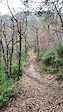
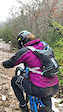
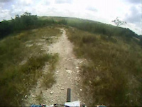
Photos of Millau Mountain Bike
Videos of Millau Mountain Bike
trail: Pump & Jump Trail
0:54 |
45 |
Jan 5, 2026
trail: DH Boundoulaou Partie Haute
6:38 |
150 |
Oct 16, 2022
trail: DH Boundoulaou Partie Haute
0:07 |
90 |
Jan 3, 2021
trail: DH Carbassas
0:13 |
131 |
Jan 3, 2021
trail: DH Carbassas
0:11 |
71 |
Jan 3, 2021
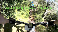
trail: Le Moulin De Corp
11:06 |
526 |
Jun 2, 2014
trail: EEMGC_4-DH La Bouteille
0:34 |
261 |
Mar 12, 2012
trail: Les Chevaux
15:51 |
447 |
Jun 6, 2011
Recent Trail Reports
| status | trail | date | condition | info | user |
|---|---|---|---|---|---|
| Les Mines (Saint-Amans) | Apr 8, 2026 @ 7:33am (America/Vancouver) Apr 8, 2026 | Ideal | provencemb B MTB Co | ||
| La Pouncho 2024 | Apr 8, 2026 @ 7:33am (America/Vancouver) Apr 8, 2026 | Ideal | provencemb B MTB Co | ||
| Plouc | Apr 8, 2026 @ 7:32am (America/Vancouver) Apr 8, 2026 | Ideal | provencemb B MTB Co | ||
| DH Ravin du Salzet | Apr 4, 2026 @ 9:07pm (Europe/Paris) Apr 4, 2026 | Dry | provencemb B MTB Co | ||
| DH Boundoulaou Partie Basse | Mar 29, 2026 @ 8:06pm (Europe/Paris) Mar 29, 2026 | Ideal | qfeger C&B | ||
| DH Boundoulaou Partie Haute | Mar 29, 2026 @ 8:05pm (Europe/Paris) Mar 29, 2026 | Ideal | qfeger C&B | ||
| DH Millau | Dec 29, 2025 @ 3:50pm (Europe/Andorra) Dec 29, 2025 | Dry | DavidClaval | ||
| Pump & Jump Trail | Dec 29, 2025 @ 3:50pm (Europe/Andorra) Dec 29, 2025 | Ideal | DavidClaval | ||
| Les Chevaux | Jul 21, 2025 @ 3:16am Jul 21, 2025 | Dry | bikemaier | ||
| DH La descente qui n'en finit pas | Jun 23, 2025 @ 1:10pm Jun 23, 2025 | Ideal | jaseridesbikes |
Activity Feed
| username | action | type | title | date |
|---|---|---|---|---|
| alb-bdr | wishlist | trail | activity #97422015 and 3 more | Jun 20, 2026 @ 12:18pm 3 days |
| alpingreg | wishlist | trail | activity #97306464 | Jun 19, 2026 @ 3:56am Jun 19, 2026 |
| SebJJ | ridden | trail | activity #96972774 and 5 more | Jun 14, 2026 @ 8:37am Jun 14, 2026 |
| Chemini | wishlist | trail | activity #94447592 | May 10, 2026 @ 11:51am May 10, 2026 |
| D-evobike | wishlist | trail | activity #93735180 and 1 more | Apr 30, 2026 @ 2:30pm Apr 30, 2026 |
Recent Comments
| username | type | title | comment | date |
|---|---|---|---|---|
| trail | descente agréable et panoramique qui dure .... | Apr 9, 2026 @ 7:40am Apr 9, 2026 | ||
| trail | Inroulable, des arbres couchés partout sur la... | Feb 23, 2026 @ 9:09am Feb 23, 2026 | ||
| trail | Great track definitely not XC it’s an enduro... | Aug 30, 2025 @ 8:04am Aug 30, 2025 | ||
| trail | Trail incroyable ! D’abord du sous bois... | Aug 10, 2025 @ 1:35am Aug 10, 2025 | ||
| trail | Itinéraire vraiment beau, ambiance lunaire... | Jun 9, 2025 @ 1:56pm Jun 9, 2025 |
Local Badges
-

Epic Ride Climb 2k149 awarded -

Climbing 10k Badge26 awarded -

Climbing 100k Badge0 awarded -

Epic Ride Descent 2k184 awarded -

Descent 10k Badge31 awarded -

Descent 100k Badge0 awarded
Activity Type Stats
| activitytype | trails | distance | descent | descent distance | total vertical | rating | global rank | state rank | photos | reports | routes | ridelogs |
|---|---|---|---|---|---|---|---|---|---|---|---|---|
| Mountain Bike | 141 | 192 miles | 69,905 ft | 113 miles | 2,083 ft | #990 | #14 | 119 | 185 | 5 | 2,054 | |
| E-Bike | 120 | 168 miles | 58,773 ft | 100 miles | 2,083 ft | #668 | #51 | 178 | 4 | 514 | ||
| Horse | 2 | 2 miles | 984 ft | 2 miles | 961 ft | 9 | 5 | |||||
| Hike | 72 | 78 miles | 23,658 ft | 39 miles | 1,850 ft | #2,613 | #64 | 151 | 1 | 193 | ||
| Trail Running | 73 | 79 miles | 25,102 ft | 40 miles | 1,850 ft | #2,044 | #56 | 151 | 1 | 186 |
Frequently Asked Questions About Millau
▼
What are the best places to ride in Millau?
Millau has 3 areas to explore for mountain biking. The top rated areas are:
▼
What are the highest rated mountain biking trails in Millau?
The highest rated mountain biking trails in Millau are:
- DH La descente qui n'en finit pas (4.2/5)
- La Pouncho 2024 (4.1/5)
- Rock&Raide (4.1/5)
- Enduro Viaduc Gauche (4.1/5)
- DH Les Molières V1 (4.1/5)
▼
What is the best time of the year to ride in Millau?
Based on ride log data, the most popular months to ride in Millau are:
- August (21 activities)
- October (16 activities)
- July (12 activities)
▼
Where can I park to ride in Millau?
There are 6 parking locations listed in Millau. The most popular parking spots are: View all parking and trailhead locations on the map to plan your visit.
Activities
Trails
- By canadaka
 Trailforks & contributors
 - Admins: max2vtt, qfeger, max2vtt, freerider48, qfeger, ValAnouilh, maxpgt
- #16001 - 8,121 views
- millau activity log | embed map of Millau mountain bike trails | millau mountain biking points of interest
Downloading of trail gps tracks in kml & gpx formats is enabled for Millau.
You must login to download files.