close
-
Layers w
- Weather Layers
- Pro
- Pro
- Pro
- Pro
- Pro
- Pro
- More Layers
- Pro
- Pro
- Pro
- Pro
-
Upgrade to

3D
Trail Conditions
- Unknown
- Snow Groomed
- Snow Packed
- Snow Covered
- Snow Cover Partial
- Freeze/thaw Cycle
- Icy
- Prevalent Mud
- Wet
- Variable
- Ideal
- Dry
- Very Dry
Trail Flow (Ridden Direction)
Trailforks scans users ridelogs to determine the most popular direction each trail is ridden. A good flowing trail network will have most trails flowing in a single direction according to their intension.
The colour categories are based on what percentage of riders are riding a trail in its intended direction.
The colour categories are based on what percentage of riders are riding a trail in its intended direction.
- > 96%
- > 90%
- > 80%
- > 70%
- > 50%
- < 50%
- bi-directional trail
- no data
Trail Last Ridden
Trailforks scans ridelogs to determine the last time a trail was ridden.
- < 2 days
- < 1 week
- < 2 weeks
- < 1 month
- < 6 months
- > 6 months
Trail Ridden Direction
The intended direction a trail should be ridden.
- Downhill Only
- Downhill Primary
- Both Directions
- Uphill Primary
- Uphill Only
- One Direction
Contribute Details
Colors indicate trail is missing specified detail.
- Description
- Photos
- Description & Photos
- Videos
Trail Popularity ?
Trailforks scans ridelogs to determine which trails are ridden the most in the last 9 months.
Trails are compared with nearby trails in the same city region with a possible 25 colour shades.
Think of this as a heatmap, more rides = more kinetic energy = warmer colors.
- most popular
- popular
- less popular
- not popular
ATV/ORV/OHV Filter
Max Vehicle Width
inches
US Cell Coverage
Legend

Radar Time
Activity Recordings
Trailforks uses anonymized public activity data.
?
Activity Recordings
Trailforks uses anonymized public activity data.
?
Personal Heatmap
▶
Activity Types
all
/
none
▶
Options
2
Date range
month
–
Winter Trails
Warning
A routing network for winter maps does not exist. Selecting trails using the winter trails layer has been disabled.
Missing Trails
Most Popular
Least Popular
Trails are colored based on popularity. The more popular a trail is, the more red. Less popular trails trend towards green.
Jump Magnitude Heatmap
Heatmap of where riders jump on trails. Zoom in to see individual jumps, click circles to view jump details.
BC Backroad Status
![map legend]()
Service Road Atlas is a free to use, community-driven service for viewing and creating reports on the numerous back-country service roads around B.C. and Alberta.

Slope Aspect
Direction the slope faces
Trails Deemphasized
Trails are shown in grey.
Only show trails with no bike usage.
Suggested Layers
Based on selected activity type
Save the current map location and zoom level as your default home location whenever this page is loaded.
Save
No description for Millcreek has been added yet!
Login or register to submit one.
Activities Click to view
- Mountain Bike
51 trails
- E-Bike
13 trails
- Gravel Bike
0 trails
- Adaptive Bike
0 trails
- Horse
15 trails
- Hike
63 trails
- Trail Running
75 trails
- Dirtbike/Moto
0 trails
- ATV/ORV/OHV
0 trails
- Snowmobile
0 trails
- Snowshoe
17 trails
- Downhill Ski
1 trails
- Backcountry Ski
15 trails
- Nordic Ski
5 trails
Region Details
- 2
- 1
- 3
- 21
- 11
Region Status
Open as of Jun 14, 2026Stats
- Avg Trail Rating
- Trails (view details)
- 62
- Trails Mountain Bike
- 51
- Trails E-Bike
- 13
- Trails Horse
- 15
- Trails Hike
- 77
- Trails Trail Running
- 75
- Trails Snowshoe
- 17
- Trails Downhill Ski
- 1
- Trails Backcountry Ski
- 15
- Trails Nordic Ski
- 5
- Total Distance
- 107 miles
- Total Descent
- 24,296 ft
- Total Vertical
- 5,405 ft
- Highest Trailhead
- 10,241 ft
- Reports
- 1,626
- Photos
- 405
- Ridden Counter
- 47,894
Sub Regions
-
Lower Mill Creek Canyon
- 1
- 3
- 13
- 9
-
Upper Mill Creek Canyon
- 10
- 3
Popular Millcreek Mountain Biking Trails
• 100 ★ 4.9 • 2 miles • 167 ft • 5,514 •
Amazing scenery, great views of both sides, but trail is washed out and wide in places.
• 100 ★ 3.0 • 699 ft • 61 ft • 3,253 •
Fall 2021 re-route which bypasses a steep janky section of old dirt road on the PC side of the ridge with some single track on the BCC side
• 85 ★ 4.6 • 3 miles • 31 ft • 3,169 •
Section between and is fabulous singletrack with a gradual grade. The upper part gets steeper and much of the trail is old 4WD road. Gets a lot of traffic, especially downhill coming off the ridge.
• 90 ★ 4.3 • 2,159 ft • 0 ft • 3,034 •
The upper most segment of the new trail connecting the bottom part of to further down Mill Creek Canyon.
• 85 ★ 3.5 • 7 miles • 780 ft • 2,884 •
Flowy and fast, not the greatest trail, but close to town, and the best way to extend a ride coming from Mill Creek Canyon TH up top
• 90 ★ 4.3 • 1 mile • 36 ft • 2,695 •
This trail winds along the canyon above the road. Trail has straight sections with roots and rolls you can pop off of, but every 2-300m there is a tight turn to navigate a root or gulley, falling in these locations would be bad (exposure).
• 95 ★ 4.1 • 2 miles • 98 ft • 2,507 •
This trail connects the Upper Millcreek trails to Lower Pipeline without riding on the road. Fantastic route on the up or the down! Now you can exit Big Water and stay on singletrack all the way to Elbow Fork! The trail winds high above...
• 80 ★ 4.0 • 2,228 ft • 5 ft • 2,179 •
Top part is very steep and wide. Just goes straight down.
Millcreek Mountain Bike Routes
★ 4.0 • 4 miles • 128 ft • 2 • Shuttled •
4 miles of new trail as of Spring 2022 that has the best riding in Millcreek Canyon. Amazing job by the...
36 miles • 5,576 ft • 10 •
Classic loop from the Millcreek Elbow with loads of shady green northsides and the crest, plus the...
4 miles • 153 ft • 3 • Shuttled •
4 miles of new trail as of Spring 2022 that has the best riding in Millcreek Canyon. Amazing job by the...
★ 3.5 • 12 miles • 2,432 ft • 6 • Loop •
Great warm up to Dog before tech climbing to Desolation Lake and finish off with the best part of the...
3 miles • 776 ft • 2 •
4 miles • 401 ft • 1 • Out & Back •
This is a quick easy ride for someone looking for little elevation gain or loss.
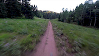
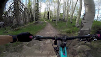
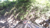
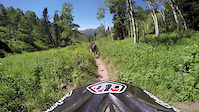
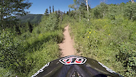
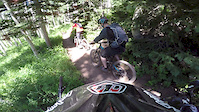
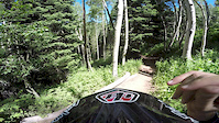
Photos of Millcreek Mountain Bike
Videos of Millcreek Mountain Bike
trail: Big Water
11:19 |
|
Aug 4, 2020
trail: Wasatch Crest (North)
0:23 |
381 |
Jul 27, 2019
trail: Wasatch Crest (North)
0:02 |
231 |
Jun 11, 2018
trail: Wasatch Crest (North)
0:11 |
54 |
Jul 5, 2015
trail: Wasatch Crest (North)
4:16 |
91 |
Jul 5, 2015
trail: Wasatch Crest (North)
2:29 |
26 |
Jul 5, 2015
trail: Wasatch Crest (North)
3:09 |
33 |
Jul 5, 2015
trail: Wasatch Crest (North)
2:17 |
19 |
Jul 5, 2015
Current Trail Warnings
| status | trail | date | condition | user | info |
|---|---|---|---|---|---|
| Lower Little Water (049) | Jun 12, 2026 @ 10:05pm (America/Denver) Jun 12, 2026 | Unknown | wasatchmtb | Closed because of millcreek road construction |
Recent Trail Reports
National Scenic Trails & Official Routes
-
Bonneville Shoreline Trail
- Mountain Bike
- E-Bike
- Horse
- Hike
- Trail Running
- Snowshoe
- Nordic Ski
-
Great Western Trail
- Mountain Bike
- E-Bike
- Horse
- Hike
- Trail Running
- Dirtbike/Moto
- ATV/ORV/OHV


Activity Feed
| username | action | type | title | date |
|---|---|---|---|---|
| ErictxDbvO | wishlist | trail | activity #97539079 | Jun 21, 2026 @ 7:41pm 1 day |
| gus894 | ridden | trail | activity #97505356 | Jun 21, 2026 @ 11:32am 2 days |
| van-dezy | ridden | trail | activity #97248995 | Jun 18, 2026 @ 6:55am Jun 18, 2026 |
| Ceara9QZa2q | wishlist | trail | activity #97182931 | Jun 17, 2026 @ 7:42am Jun 17, 2026 |
| Hidec | add | report | activity #96997559 and 2 more | Jun 14, 2026 @ 12:51pm Jun 14, 2026 |
Recent Comments
| username | type | title | comment | date |
|---|---|---|---|---|
| trail | South entrance off Teton drive is not good for... | May 30, 2026 @ 5:35pm May 30, 2026 | ||
| trail | Needs review | May 15, 2026 @ 8:29am May 15, 2026 | ||
| report | Sly Fox clearly says the trail is open, but... | Apr 30, 2026 @ 4:21pm Apr 30, 2026 | ||
| trail | Extremely underwhelming. Could use a lot of work | Apr 1, 2026 @ 9:11pm Apr 1, 2026 | ||
| trail | Good climb with 3 semi tight turns and two... | Mar 27, 2026 @ 6:25pm Mar 27, 2026 |
Local Badges
-

Completionist0 awarded -

10 Blue Trails295 awarded -

Epic Mountain Bike Climb 2k212 awarded -

Climbing 10k Badge145 awarded -

Mountain Biking 100k Badge5 awarded -

Epic Ride Descent 2k212 awarded
Activity Type Stats
| activitytype | trails | distance | descent | descent distance | total vertical | rating | global rank | state rank | photos | reports | routes | ridelogs |
|---|---|---|---|---|---|---|---|---|---|---|---|---|
| Mountain Bike | 51 | 49 miles | 10,069 ft | 20 miles | 4,829 ft | #811 | #317 | 363 | 1,656 | 20 | 19,428 | |
| E-Bike | 13 | 8 miles | 505 ft | 4,413 ft | 2,762 ft | #6,063 | #1,854 | 1,324 | 3 | 1,043 | ||
| Horse | 15 | 21 miles | 6,572 ft | 13 miles | 4,537 ft | #837 | #601 | 11 | 344 | |||
| Hike | 63 | 107 miles | 24,295 ft | 40 miles | 5,404 ft | #366 | #174 | 46 | 1,690 | 31 | 15,125 | |
| Trail Running | 75 | 104 miles | 24,295 ft | 40 miles | 5,404 ft | #841 | #318 | 1 | 1,689 | 28 | 12,583 | |
| Snowshoe | 17 | 23 miles | 4,593 ft | 8 miles | 2,835 ft | #662 | #276 | 136 | 17 | 130 | ||
| Downhill Ski | 1 | 6 miles | 499 ft | 3,963 ft | 2,762 ft | #728 | #358 | 40 | 185 | |||
| Backcountry Ski | 15 | 21 miles | 4,491 ft | 8 miles | 4,085 ft | #123 | #26 | 120 | 9,916 | |||
| Nordic Ski | 5 | 7 miles | 499 ft | 4,052 ft | 2,762 ft | #886 | #357 | 42 | 1 | 1,611 |
Frequently Asked Questions About Millcreek
▼
What are the best places to ride in Millcreek?
Millcreek has 3 areas to explore for mountain biking. The top rated areas are:
▼
What are the highest rated mountain biking trails in Millcreek?
The highest rated mountain biking trails in Millcreek are:
- Wasatch Crest (North) (4.7/5)
- Great Western Trail (4.5/5)
- Red Pine Rim (4.3/5)
- Mill Creek Meadows (4.3/5)
- Big Water (4.2/5)
▼
What is the best time of the year to ride in Millcreek?
Based on ride log data, the most popular months to ride in Millcreek are:
- July (159 activities)
- August (106 activities)
- September (106 activities)
▼
Where can I park to ride in Millcreek?
There are 17 parking locations listed in Millcreek. The most popular parking spots are: View all parking and trailhead locations on the map to plan your visit.
Activities
Trails
- By jasonmalczyk
 Trailforks & contributors
 - Admins: jkwilliamz, UtahJohn, jpmcghee, jasonmalczyk
- #37670 - 10,620 views
- millcreek activity log | embed map of Millcreek mountain bike trails | millcreek mountain biking points of interest
Downloading of trail gps tracks in kml & gpx formats is enabled for Millcreek.
You must login to download files.