close
-
Layers w
- Weather Layers
- Pro
- Pro
- Pro
- Pro
- Pro
- Pro
- More Layers
- Pro
- Pro
- Pro
- Pro
-
Upgrade to

3D
Trail Conditions
- Unknown
- Snow Groomed
- Snow Packed
- Snow Covered
- Snow Cover Partial
- Freeze/thaw Cycle
- Icy
- Prevalent Mud
- Wet
- Variable
- Ideal
- Dry
- Very Dry
Trail Flow (Ridden Direction)
Trailforks scans users ridelogs to determine the most popular direction each trail is ridden. A good flowing trail network will have most trails flowing in a single direction according to their intension.
The colour categories are based on what percentage of riders are riding a trail in its intended direction.
The colour categories are based on what percentage of riders are riding a trail in its intended direction.
- > 96%
- > 90%
- > 80%
- > 70%
- > 50%
- < 50%
- bi-directional trail
- no data
Trail Last Ridden
Trailforks scans ridelogs to determine the last time a trail was ridden.
- < 2 days
- < 1 week
- < 2 weeks
- < 1 month
- < 6 months
- > 6 months
Trail Ridden Direction
The intended direction a trail should be ridden.
- Downhill Only
- Downhill Primary
- Both Directions
- Uphill Primary
- Uphill Only
- One Direction
Contribute Details
Colors indicate trail is missing specified detail.
- Description
- Photos
- Description & Photos
- Videos
Trail Popularity ?
Trailforks scans ridelogs to determine which trails are ridden the most in the last 9 months.
Trails are compared with nearby trails in the same city region with a possible 25 colour shades.
Think of this as a heatmap, more rides = more kinetic energy = warmer colors.
- most popular
- popular
- less popular
- not popular
ATV/ORV/OHV Filter
Max Vehicle Width
inches
US Cell Coverage
Legend

Radar Time
Activity Recordings
Trailforks uses anonymized public activity data.
?
Activity Recordings
Trailforks uses anonymized public activity data.
?
Personal Heatmap
▶
Activity Types
all
/
none
▶
Options
2
Date range
month
–
Winter Trails
Warning
A routing network for winter maps does not exist. Selecting trails using the winter trails layer has been disabled.
Missing Trails
Most Popular
Least Popular
Trails are colored based on popularity. The more popular a trail is, the more red. Less popular trails trend towards green.
Jump Magnitude Heatmap
Heatmap of where riders jump on trails. Zoom in to see individual jumps, click circles to view jump details.
BC Backroad Status
![map legend]()
Service Road Atlas is a free to use, community-driven service for viewing and creating reports on the numerous back-country service roads around B.C. and Alberta.

Slope Aspect
Direction the slope faces
Trails Deemphasized
Trails are shown in grey.
Only show trails with no bike usage.
Suggested Layers
Based on selected activity type
Save the current map location and zoom level as your default home location whenever this page is loaded.
SaveBeautiful multi-use trails right in the heart of Powell River. Frequented by joggers, walkers and dogs as well as cyclists.
Be courteous to all trail users
Be courteous to all trail users
Primary Trail Type: Cross-Country
 google parking directions
 Activities Click to view
- Mountain Bike
80 trails
- E-Bike
69 trails
- Horse
52 trails
- Hike
77 trails
- Trail Running
77 trails
- Dirtbike/Moto
4 trails
Region Details
- 11
- 3
- 33
- 22
- 2
- 1
Region Status
Caution as of May 5, 2026Stats
- Avg Trail Rating
- Trails (view details)
- 73
- Trails Mountain Bike
- 80
- Trails E-Bike
- 69
- Trails Horse
- 52
- Trails Hike
- 77
- Trails Trail Running
- 77
- Trails Dirtbike/Moto
- 4
- Trails Observed Trials
- 1
- Trails ATV/ORV/OHV
- 2
- Total Distance
- 27 miles
- Total Descent Distance
- 13 miles
- Total Descent
- 3,214 ft
- Total Vertical
- 628 ft
- Highest Trailhead
- 667 ft
- Reports
- 267
- Photos
- 79
- Ridden Counter
- 7,650
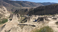
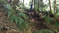
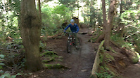
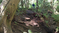
Popular Millennium Park Mountain Biking Trails
• 90 ★ 4.5 • 3,829 ft • 0 ft • 493 •
GO SLOW A popular trail used by the community built on the old rail bed of logging days of years gone by. Enjoy the view, the forest, the ocean, and the remnants of logging history of the town. This is the entrance and exit for the BC...
• 60 ★ 3.0 • 587 ft • 28 ft • 354 •
Moderately popular green difficulty singletrack. This mountain bike primary trail can be used both directions and has a moderate overall physical rating with a 28 ft blue climb. On average it takes 2 minutes to complete this trail.
• 55 ★ 3.0 • 200 ft • 0 ft • 309 •
Moderately popular green difficulty singletrack. This multi-use trail can be used both directions and has a easy overall physical rating with a 0 ft green climb. It features bridge. Trail visibility is always easy to follow. On average it takes minutes to complete this trail.
• 70 ★ 4.5 • 1,020 ft • 0 ft • 277 •
Popular green difficulty family friendly singletrack. This mountain bike primary trail can be used both directions and has a easy overall physical rating with a 0 ft green climb. Trail visibility is always easy to follow. On average it takes 1 minutes to complete this trail.
• 50 ★ 5.0 • 856 ft • 0 ft • 213 •
Moderately popular blue difficulty singletrack. This mountain bike primary trail can be used both directions and has a moderate overall physical rating with a 0 ft blue climb. On average it takes 3 minutes to complete this trail.
• 70 ★ 3.0 • 1,870 ft • 0 ft • 206 •
Let go of your brakes and fly fast. Sometimes walkers come up from Hwy so eyes peeled wide open
• 50 ★ 3.4 • 3,681 ft • 195 ft • 192 •
Moderately popular blue difficulty singletrack. This mountain bike primary trail can be used both directions and has a moderate overall physical rating with a 195 ft blue climb. On average it takes 8 minutes to complete this trail.
Millennium Park Mountain Bike Routes
QRCA Halloween BIG RIDERS 2022 Featured
★ 5.0 • 4 miles • 250 ft • 7 • Loop •
Halloween sweat for a sweet
6 miles • 378 ft • 1 •
Take a route through Westview mostly off-Joyce all the way to Townsite Brewing!
2 miles • 149 ft • 3 •
route is for 2023 liltlin's charity Dipper Fiver Ride
16 miles • 1,331 ft • 10 • Race •
Island Cup XC - Lake Marathon - Medium Course
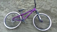
Photos of Millennium Park Mountain Bike
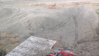
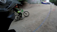
Videos of Millennium Park Mountain Bike
trail: Valentine's Arrow (Pit)
3:14 |
281 |
Jun 27, 2017
trail: McFall Creek Trail
0:10 |
260 |
Apr 30, 2017
trail: McFall Creek Trail
0:11 |
170 |
Apr 30, 2017
trail: McFall Creek Trail
0:09 |
127 |
Apr 30, 2017
trail: Valentine's Arrow (Pit)
0:02 |
226 |
Nov 28, 2016
trail: Valentine's Arrow (Pit)
0:14 |
83 |
Feb 20, 2016

trail: Valentine's Arrow (Pit)
0:09 |
46 |
Feb 16, 2016
trail: Coburn connector
0:55 |
60 |
Sep 8, 2015
Recent Trail Reports
| status | trail | date | condition | info | user |
|---|---|---|---|---|---|
| McFall Creek Trail | May 5, 2026 @ 4:18pm (America/Vancouver) May 5, 2026 | Ideal | 421coast | ||
| Dwight Trail | May 5, 2026 @ 4:18pm (America/Vancouver) May 5, 2026 | Ideal | 421coast | ||
| Coburn Connector (Heart) | Mar 26, 2026 @ 6:10pm (America/Vancouver) Mar 26, 2026 | Unknown | adamskinner | ||
| Cupid | Feb 22, 2026 @ 5:30pm (America/Vancouver) Feb 22, 2026 | Wet | loamwizard | ||
| DUCK | Dec 14, 2025 @ 8:18pm (America/Vancouver) Dec 14, 2025 | Unknown | CVollmin40 | ||
| McFall Bridge | Apr 23, 2025 @ 4:18pm Apr 23, 2025 | Ideal | julievdh | ||
| Unaymit Trail | Apr 23, 2025 @ 4:18pm Apr 23, 2025 | Ideal | julievdh | ||
| McGuffie Creek Trail | Apr 23, 2025 @ 4:18pm Apr 23, 2025 | Ideal | julievdh | ||
| Brooks Turf Road | Feb 27, 2025 @ 5:56pm Feb 27, 2025 | Variable | JakeBoulder | ||
| Wys Crossing | Jan 19, 2025 @ 2:49pm Jan 19, 2025 | Ideal | gidgit66 |
Activity Feed
| username | action | type | title | date |
|---|---|---|---|---|
| dennistonjo | add | photo | activity #96900718 and 1 more | Jun 13, 2026 @ 11:36am Jun 13, 2026 |
| kaiMikk11 | vote | trail | activity #96782998 | Jun 11, 2026 @ 8:57pm Jun 11, 2026 |
| aamoore122 | add | photo | activity #95978116 | May 31, 2026 @ 2:26pm May 31, 2026 |
| 421coast | vote | trail | activity #94151745 and 2 more | May 6, 2026 @ 6:33am May 6, 2026 |
| 421coast | add | report | activity #94148431 and 1 more | May 6, 2026 @ 5:05am May 6, 2026 |
Recent Comments
| username | type | title | comment | date |
|---|---|---|---|---|
| trail | Easy access for a quick after work ride. | Feb 22, 2026 @ 4:03pm Feb 22, 2026 | ||
| report | Pd did | Aug 18, 2025 @ 4:31pm Aug 18, 2025 | ||
| trail | Tree down across trail | Nov 24, 2024 @ 1:23pm Nov 24, 2024 | ||
| trail | Big tree down so duck when your coming through | Nov 23, 2024 @ 3:35pm Nov 23, 2024 | ||
| report | Maple branches and a few ferns on lower 1/3... | Jun 8, 2024 @ 1:28pm Jun 8, 2024 |
Nearby Areas
| name | distance | ||||
|---|---|---|---|---|---|
| Gallagher Hill | 1 | 3 | 11 | 2 | 1.4 km |
| Penticton Street Maze | 16 | 31 | 3.8 km | ||
| West Lake Trails | 6 | 19 | 8 | 1 | 4.1 km |
| Duck Lake Trails | 13 | 53 | 9 | 4.1 km | |
| Mt. Mahony | 8 | 11 | 12 | 4.6 km |
Local Badges
-

Completionist0 awarded
Activity Type Stats
| activitytype | trails | distance | descent | descent distance | total vertical | rating | global rank | state rank | photos | reports | routes | ridelogs |
|---|---|---|---|---|---|---|---|---|---|---|---|---|
| Mountain Bike | 80 | 26 miles | 2,969 ft | 12 miles | 627 ft | #3,560 | #162 | 72 | 267 | 9 | 4,444 | |
| E-Bike | 69 | 26 miles | 2,969 ft | 12 miles | 627 ft | #3,516 | #128 | 216 | 9 | 132 | ||
| Horse | 52 | 22 miles | 2,100 ft | 10 miles | 627 ft | #1,142 | #38 | 85 | 3 | |||
| Hike | 77 | 26 miles | 2,530 ft | 11 miles | 627 ft | #5,270 | #224 | 7 | 256 | 1 | 1,050 | |
| Trail Running | 77 | 26 miles | 2,530 ft | 11 miles | 627 ft | #4,096 | #131 | 256 | 1 | 1,372 | ||
| Dirtbike/Moto | 4 | 6 miles | 558 ft | 3 miles | 417 ft | #836 | #72 | 26 | 12 | |||
| Observed Trials | 1 | 5 miles | 312 ft | 2 miles | 223 ft | 85 | ||||||
| ATV/ORV/OHV | 2 | 5 miles | 312 ft | 2 miles | 223 ft | 26 | 4 |
Frequently Asked Questions About Millennium Park
▼
What are the highest rated mountain biking trails in Millennium Park?
The highest rated mountain biking trails in Millennium Park are:
- Willingdon Beach Trail (4.2/5)
- McFall Creek Trail (4.2/5)
- CAMRA Ale Trail (4.1/5)
- Cut Connector Trail (4.1/5)
- DUCK (4.1/5)
▼
What is the best time of the year to ride in Millennium Park?
Based on ride log data, the most popular months to ride in Millennium Park are:
- July (106 activities)
- May (93 activities)
- October (88 activities)
▼
Where can I park to ride in Millennium Park?
There are 1 parking locations listed in Millennium Park. The most popular parking spots are:
▼
What is the longest trail in Millennium Park?
The longest trail in Millennium Park is Complex Community Path at 4,708 ft. View all trails sorted by distance.
Activities
Trails
Points of Interest
- By Rubrewer
 & contributors
 - Admins: QRCA, MMSC
- #11419 - 8,901 views
- millennium park activity log | embed map of Millennium Park mountain bike trails | millennium park mountain biking points of interest
Downloading of trail gps tracks in kml & gpx formats is enabled for Millennium Park.
You must login to download files.