close
-
Layers w
- Weather Layers
- Pro
- Pro
- Pro
- Pro
- Pro
- Pro
- More Layers
- Pro
- Pro
- Pro
- Pro
-
Upgrade to

3D
Trail Conditions
- Unknown
- Snow Groomed
- Snow Packed
- Snow Covered
- Snow Cover Partial
- Freeze/thaw Cycle
- Icy
- Prevalent Mud
- Wet
- Variable
- Ideal
- Dry
- Very Dry
Trail Flow (Ridden Direction)
Trailforks scans users ridelogs to determine the most popular direction each trail is ridden. A good flowing trail network will have most trails flowing in a single direction according to their intension.
The colour categories are based on what percentage of riders are riding a trail in its intended direction.
The colour categories are based on what percentage of riders are riding a trail in its intended direction.
- > 96%
- > 90%
- > 80%
- > 70%
- > 50%
- < 50%
- bi-directional trail
- no data
Trail Last Ridden
Trailforks scans ridelogs to determine the last time a trail was ridden.
- < 2 days
- < 1 week
- < 2 weeks
- < 1 month
- < 6 months
- > 6 months
Trail Ridden Direction
The intended direction a trail should be ridden.
- Downhill Only
- Downhill Primary
- Both Directions
- Uphill Primary
- Uphill Only
- One Direction
Contribute Details
Colors indicate trail is missing specified detail.
- Description
- Photos
- Description & Photos
- Videos
Trail Popularity ?
Trailforks scans ridelogs to determine which trails are ridden the most in the last 9 months.
Trails are compared with nearby trails in the same city region with a possible 25 colour shades.
Think of this as a heatmap, more rides = more kinetic energy = warmer colors.
- most popular
- popular
- less popular
- not popular
ATV/ORV/OHV Filter
Max Vehicle Width
inches
US Cell Coverage
Legend

Radar Time
Activity Recordings
Trailforks uses anonymized public activity data.
?
Activity Recordings
Trailforks uses anonymized public activity data.
?
Personal Heatmap
▶
Activity Types
all
/
none
▶
Options
2
Date range
month
–
Winter Trails
Warning
A routing network for winter maps does not exist. Selecting trails using the winter trails layer has been disabled.
Missing Trails
Most Popular
Least Popular
Trails are colored based on popularity. The more popular a trail is, the more red. Less popular trails trend towards green.
Jump Magnitude Heatmap
Heatmap of where riders jump on trails. Zoom in to see individual jumps, click circles to view jump details.
BC Backroad Status
![map legend]()
Service Road Atlas is a free to use, community-driven service for viewing and creating reports on the numerous back-country service roads around B.C. and Alberta.

Slope Aspect
Direction the slope faces
Trails Deemphasized
Trails are shown in grey.
Only show trails with no bike usage.
Suggested Layers
Based on selected activity type
Save the current map location and zoom level as your default home location whenever this page is loaded.
Save
No description for Minehead has been added yet!
Login or register to submit one.
This region uses the Uk/Euro style trail grading system.
Activities Click to view
- Mountain Bike
96 trails
- E-Bike
9 trails
- Gravel Bike
0 trails
- Adaptive Bike
0 trails
- Winter Fat Bike
0 trails
- Horse
2 trails
- Hike
94 trails
- Trail Running
94 trails
- Dirtbike/Moto
0 trails
Region Details
- 6
- 32
- 54
- 2
Region Status
Open as of Jun 13, 2026Stats
- Avg Trail Rating
- Trails (view details)
- 95
- Trails Mountain Bike
- 96
- Trails E-Bike
- 9
- Trails Horse
- 2
- Trails Hike
- 94
- Trails Trail Running
- 94
- Total Distance
- 79 miles
- Total Descent
- 30,306 ft
- Total Vertical
- 1,541 ft
- Highest Trailhead
- 1,680 ft
- Reports
- 162
- Photos
- 29
- Ridden Counter
- 6,563
Sub Regions
-
Dunkery, Horner Woods & Minehead
- 25
- 39
- 1
Popular Minehead Mountain Biking Trails
• 100 ★ 0.0 • 2,717 ft • 0 ft • 234 •
Popular blue difficulty singletrack. This mountain bike primary trail can be used downhill primary. On average it takes 10 minutes to complete this trail.
• 90 ★ 3.5 • 2 miles • 0 ft • 191 •
Popular blue difficulty singletrack. This mountain bike primary trail can be used downhill primary. On average it takes 15 minutes to complete this trail.
• 100 ★ 0.0 • 2,923 ft • 0 ft • 188 •
Popular blue difficulty singletrack. This mountain bike primary trail can be used downhill primary. On average it takes 3 minutes to complete this trail.
• 60 ★ 0.0 • 1,636 ft • 0 ft • 183 •
Moderately popular blue difficulty singletrack. This mountain bike primary trail can be used downhill primary. On average it takes 4 minutes to complete this trail.
• 100 ★ 0.0 • 3,084 ft • 0 ft • 175 •
Popular blue difficulty singletrack. This mountain bike primary trail can be used both directions. On average it takes 6 minutes to complete this trail.
• 95 ★ 3.7 • 5,130 ft • 0 ft • 169 •
Popular blue difficulty singletrack. This mountain bike primary trail can be used downhill primary. On average it takes 8 minutes to complete this trail.
• 50 ★ 0.0 • 2,776 ft • 0 ft • 163 •
Moderately popular blue difficulty singletrack. This mountain bike primary trail can be used downhill primary. On average it takes 7 minutes to complete this trail.
• 80 ★ 0.0 • 2 miles • 212 ft • 140 •
Popular green difficulty singletrack. This mountain bike primary trail can be used both directions. On average it takes 14 minutes to complete this trail.
Minehead Mountain Bike Routes
★ 5.0 • 10 miles • 2,404 ft • 17 •
Starting in Porlock Weir, a steep climb takes you up to bridleway for a sweet descent. More elevation loss...
★ 3.2 • 23 miles • 3,538 ft • 1 •
The ride starts in Porlock, giving you a chance to stock up on calories — you’ll need them! After a...
★ 4.5 • 10 miles • 2,366 ft • 8 • Loop •
Starting at a carpark, this loop combines some of the best and trickiest singletrack near to Minehead.
★ 5.0 • 18 miles • 3,210 ft • 30 • Loop •
A tough loop with steep climbs and rough terrain but incredibly rewarding singletrack descents. Exmoor is...
★ 3.0 • 21 miles • 2,721 ft • 1 • Loop •
Nice loop from the Ship Inn at Porlock taking in the best of Hawkcombe, Horner Woods and Dunkery Beacon.
★ 5.0 • 10 miles • 1,908 ft • 17 •
A shortish but fun loop with some stunning singletrack which flowers brilliantly in springtime.
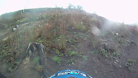
Videos of Minehead Mountain Bike
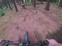
trail: The Magic Carpet Ride
0:08 |
46 |
Jul 1, 2025

trail: The Magic Carpet Ride
0:08 |
23 |
Jul 1, 2025
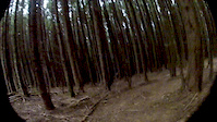
trail: Superstar
4:05 |
229 |
Dec 2, 2016

trail: Superstar
2:29 |
981 |
Aug 8, 2012
trail: OO
0:55 |
249 |
Aug 9, 2011

trail: Superstar
4:48 |
3174 |
Apr 24, 2011

trail: Maurice
4:39 |
139154 |
Aug 24, 2009
Recent Trail Reports
| status | trail | date | condition | info | user |
|---|---|---|---|---|---|
| Bridleway | Mar 4, 2026 @ 5:34pm (Europe/London) Mar 4, 2026 | Ideal | mike138 | ||
| Sliver me Timbers | Dec 7, 2025 @ 6:50pm (Europe/London) Dec 7, 2025 | Wet | mike138 | ||
| Coleridge Way | Oct 1, 2025 @ 9:32am (Europe/Guernsey) Oct 1, 2025 | Ideal | mike138 | ||
| Bratton DH Track | May 27, 2025 @ 4:03pm May 27, 2025 | Variable | TheDragoPenguinH9PElr | ||
| All show and no go | May 27, 2025 @ 4:03pm May 27, 2025 | Wet | TheDragoPenguinH9PElr | ||
| The Magic Carpet Ride | May 27, 2025 @ 4:03pm May 27, 2025 | Prevalent Mud | TheDragoPenguinH9PElr | ||
| Lang Combe 15 Splashes | May 15, 2025 @ 12:20pm May 15, 2025 | Unknown | georgeeustice | ||
| Cat's Scramble | Dec 24, 2024 @ 2:17am Dec 24, 2024 | Variable | russell-mtb | ||
| Horner Zig Zags | Dec 24, 2024 @ 2:15am Dec 24, 2024 | Ideal | russell-mtb | ||
| Mondraker Gravity Descent | Dec 24, 2024 @ 2:12am Dec 24, 2024 | Variable | russell-mtb |
Activity Feed
| username | action | type | title | date |
|---|---|---|---|---|
| marty77 | ridden | trail | activity #95999532 and 1 more | May 31, 2026 @ 10:21pm May 31, 2026 |
| Rockmonkey | ridden | route | activity #95435516 | May 24, 2026 @ 12:24pm May 24, 2026 |
| VvkZ7S | wishlist | route | activity #95427915 | May 24, 2026 @ 11:06am May 24, 2026 |
| RogGROG1 | wishlist | route | activity #95294442 | May 23, 2026 @ 12:55am May 23, 2026 |
| Jzdaniel | wishlist | route | activity #95239175 | May 22, 2026 @ 6:59am May 22, 2026 |
Recent Comments
| username | type | title | comment | date |
|---|---|---|---|---|
| trail | Clear top section, after road crossing there... | Oct 1, 2025 @ 8:11am Oct 1, 2025 | ||
| trail | Great top half flow section. Bottom section... | May 4, 2025 @ 12:25pm May 4, 2025 | ||
| trail | Tree down top section | May 3, 2025 @ 6:56am May 3, 2025 | ||
| trail | Great trail underneath all the leaves and... | May 3, 2025 @ 6:56am May 3, 2025 | ||
| report | Forestry work clear fell area so no trees left | Mar 31, 2024 @ 12:28pm Mar 31, 2024 |
Local Badges
-

10 Green Trails15 awarded -

10 Blue Trails118 awarded -

Epic Ride Climb 2k84 awarded -

Climbing 10k Badge43 awarded -

Climbing 100k Badge4 awarded -

Epic Ride Descent 2k97 awarded
Activity Type Stats
| activitytype | trails | distance | descent | descent distance | total vertical | rating | global rank | state rank | photos | reports | routes | ridelogs |
|---|---|---|---|---|---|---|---|---|---|---|---|---|
| Mountain Bike | 96 | 79 miles | 30,305 ft | 53 miles | 1,542 ft | #1,536 | #56 | 27 | 160 | 23 | 6,618 | |
| E-Bike | 9 | 9 miles | 2,854 ft | 6 miles | 630 ft | #3,698 | #134 | 2 | 128 | 2 | 1,165 | |
| Horse | 2 | 5 miles | 1,470 ft | 3 miles | 600 ft | #1,025 | #45 | 33 | ||||
| Hike | 94 | 78 miles | 29,469 ft | 52 miles | 1,542 ft | #2,333 | #51 | 157 | 1 | 422 | ||
| Trail Running | 94 | 78 miles | 29,469 ft | 52 miles | 1,542 ft | #1,876 | #42 | 157 | 1 | 171 |
Frequently Asked Questions About Minehead
▼
What are the best places to ride in Minehead?
Minehead has 1 areas to explore for mountain biking. The top rated areas are:
▼
What are the highest rated mountain biking trails in Minehead?
The highest rated mountain biking trails in Minehead are:
- Doris!!! (4.2/5)
- Quadzilla (4.2/5)
- Mondraker Gravity Descent (4.1/5)
- Bratton DH Track (4.1/5)
- All show and no go (4.1/5)
▼
What is the best time of the year to ride in Minehead?
Based on ride log data, the most popular months to ride in Minehead are:
- July (34 activities)
- May (18 activities)
- October (18 activities)
▼
Where can I park to ride in Minehead?
There are 6 parking locations listed in Minehead. The most popular parking spots are: View all parking and trailhead locations on the map to plan your visit.
Activities
Trails
Points of Interest
- By Zerograv80 & contributors
- Admins: wisey, MathieuC, cemoorelife
- #11934 - 12,923 views
- minehead activity log | embed map of Minehead mountain bike trails | minehead mountain biking points of interest
Downloading of trail gps tracks in kml & gpx formats is enabled for Minehead.
You must login to download files.