close
-
Layers w
- Weather Layers
- Pro
- Pro
- Pro
- Pro
- Pro
- Pro
- More Layers
- Pro
- Pro
- Pro
- Pro
-
Upgrade to

3D
Trail Conditions
- Unknown
- Snow Groomed
- Snow Packed
- Snow Covered
- Snow Cover Partial
- Freeze/thaw Cycle
- Icy
- Prevalent Mud
- Wet
- Variable
- Ideal
- Dry
- Very Dry
Trail Flow (Ridden Direction)
Trailforks scans users ridelogs to determine the most popular direction each trail is ridden. A good flowing trail network will have most trails flowing in a single direction according to their intension.
The colour categories are based on what percentage of riders are riding a trail in its intended direction.
The colour categories are based on what percentage of riders are riding a trail in its intended direction.
- > 96%
- > 90%
- > 80%
- > 70%
- > 50%
- < 50%
- bi-directional trail
- no data
Trail Last Ridden
Trailforks scans ridelogs to determine the last time a trail was ridden.
- < 2 days
- < 1 week
- < 2 weeks
- < 1 month
- < 6 months
- > 6 months
Trail Ridden Direction
The intended direction a trail should be ridden.
- Downhill Only
- Downhill Primary
- Both Directions
- Uphill Primary
- Uphill Only
- One Direction
Contribute Details
Colors indicate trail is missing specified detail.
- Description
- Photos
- Description & Photos
- Videos
Trail Popularity ?
Trailforks scans ridelogs to determine which trails are ridden the most in the last 9 months.
Trails are compared with nearby trails in the same city region with a possible 25 colour shades.
Think of this as a heatmap, more rides = more kinetic energy = warmer colors.
- most popular
- popular
- less popular
- not popular
ATV/ORV/OHV Filter
Max Vehicle Width
inches
US Cell Coverage
Legend

Radar Time
Activity Recordings
Trailforks uses anonymized public activity data.
?
Activity Recordings
Trailforks uses anonymized public activity data.
?
Personal Heatmap
▶
Activity Types
all
/
none
▶
Options
2
Date range
month
–
Winter Trails
Warning
A routing network for winter maps does not exist. Selecting trails using the winter trails layer has been disabled.
Missing Trails
Most Popular
Least Popular
Trails are colored based on popularity. The more popular a trail is, the more red. Less popular trails trend towards green.
Jump Magnitude Heatmap
Heatmap of where riders jump on trails. Zoom in to see individual jumps, click circles to view jump details.
BC Backroad Status
![map legend]()
Service Road Atlas is a free to use, community-driven service for viewing and creating reports on the numerous back-country service roads around B.C. and Alberta.

Slope Aspect
Direction the slope faces
Trails Deemphasized
Trails are shown in grey.
Only show trails with no bike usage.
Suggested Layers
Based on selected activity type
Save the current map location and zoom level as your default home location whenever this page is loaded.
Save
No description for Minturn has been added yet!
Login or register to submit one.
Activities Click to view
- Mountain Bike
31 trails
- E-Bike
15 trails
- Gravel Bike
0 trails
- Adaptive Bike
0 trails
- Winter Fat Bike
0 trails
- Horse
59 trails
- Hike
65 trails
- Trail Running
68 trails
- ATV/ORV/OHV
6 trails
- Snowshoe
18 trails
- Downhill Ski
8 trails
- Backcountry Ski
17 trails
- Nordic Ski
15 trails
Region Details
- 5
- 5
- 10
- 7
Region Status
Caution as of Jun 12, 2026Local Trail Association
Stats
- Avg Trail Rating
- Trails (view details)
- 61
- Trails Mountain Bike
- 31
- Trails E-Bike
- 15
- Trails Horse
- 59
- Trails Hike
- 68
- Trails Trail Running
- 68
- Trails Dirtbike/Moto
- 2
- Trails Observed Trials
- 1
- Trails ATV/ORV/OHV
- 6
- Trails Snowshoe
- 18
- Trails Downhill Ski
- 8
- Trails Backcountry Ski
- 17
- Trails Nordic Ski
- 15
- Total Distance
- 186 miles
- Total Descent
- 21,083 ft
- Total Vertical
- 6,248 ft
- Highest Trailhead
- 13,888 ft
- Reports
- 608
- Photos
- 462
- Ridden Counter
- 5,844
Articles
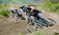
Photo Recap: Dual Slalom Thrives in an Old Railroad Town - 2024 GoPro Dual Slalom & Jump Jam Recap
Jun 18, 2024 from pinkbike.com
Since 2022 the Minturn Bike Park has been home to the GoPro Mountain Games Dual Slalom race, and this year was no exception.
Sub Regions
-
Holy Cross Wilderness Area
- 2
- 1
-
Minturn Bike Park
- 3
- 3
- 2
Popular Minturn Mountain Biking Trails
• 55 ★ 3.0 • 1,388 ft • 0 ft • 960 •
Moderately popular blue difficulty family friendly singletrack. This mountain bike primary trail can be used one direction. On average it takes 2 minutes to complete this trail.
• 100 ★ 2.8 • 5 miles • 2,044 ft • 535 •
Popular blue difficulty singletrack. This multi-use trail can be used uphill primary and has a hard overall physical rating with a 2,044 ft blue climb. On average it takes 1 hour18 minutes to complete this trail.
• 85 ★ 3.2 • 5 miles • 170 ft • 397 •
Descent into Minturn from Vail Mountain/Grand Traverse, for a Summer version of the Minturn Mile, or climb to access multiple loops or as an out and back from Minturn. From the top, starts with some flowy turns in an open meadow with...
• 95 ★ 3.5 • 617 ft • 0 ft • 203 •
Popular black diamond difficulty family friendly singletrack. This mountain bike primary trail can be used downhill primary. Adaptive MTB rating: amtb green. Trail visibility is always easy to follow. On average it takes 2 minutes to complete this trail.
• 100 ★ 0.0 • 531 ft • 32 ft • 145 •
Popular green difficulty singletrack. This mountain bike primary trail can be used both directions. On average it takes 2 minutes to complete this trail.
• 60 ★ 2.5 • 5,115 ft • 285 ft • 140 •
Ridden from Grouse to Meadow Mtn its a steep but short climb with one creek crossing.
• 90 ★ 0.0 • 728 ft • 31 ft • 129 •
Popular green difficulty family friendly singletrack. This mountain bike primary trail can be used uphill primary. On average it takes 3 minutes to complete this trail.
• 70 ★ 3.4 • 2 miles • 344 ft • 125 •
Popular blue difficulty doubletrack. This multi-use trail can be used both directions. On average it takes 13 minutes to complete this trail.
Minturn Mountain Bike Routes
★ 3.7 • 10 miles • 2,187 ft • 3 •
Start at the parking lot, climb , descend to and back to Minturn.
★ 5.0 • 23 miles • 4,221 ft • 4 • Loop •
Ride Two Elk from Minturn as a loop on nearly all single track - Oct '20 reroutes on trail make this a...
★ 4.0 • 10 miles • 2,293 ft • 5 • Loop •
Ride, run, or hike all of the trails in the area.
Photos of Minturn Mountain Bike
Videos of Minturn Mountain Bike
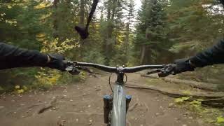
trail: Everkrisp
9:37 |
94 |
Aug 5, 2024 , Minturn

trail: West Grouse Creek
3:53 |
180 |
Jul 25, 2023 , Minturn
trail: Everkrisp
6:03 |
210 |
Jul 18, 2023 , Minturn

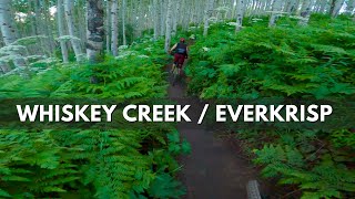
trail: Whiskey Creek
6:03 |
283 |
Jul 18, 2023 , Minturn

trail: Meadow Mountain
8:11 |
278 |
Nov 17, 2021 , Minturn

trail: Cougar Ridge
9:23 |
532 |
Oct 26, 2020 , Minturn

trail: Everkrisp
0:59 |
546 |
Jun 4, 2020 , Minturn

2:39 |
346 |
Sep 22, 2019
Current Trail Warnings
| status | trail | date | condition | user | info |
|---|---|---|---|---|---|
| Eagle-Thomasville Road | Jun 5, 2026 @ 5:15pm (America/Denver) Jun 5, 2026 | Unknown | ATV/ORV/OHV |
Recent Trail Reports
| status | trail | date | condition | info | user |
|---|---|---|---|---|---|
| Ironedge Connector | Jun 12, 2026 @ 10:34am (America/Denver) Jun 12, 2026 | Dry | esaeger1 VVMTA | ||
| Water Tank Trail | May 30, 2026 @ 9:58am (America/Denver) May 30, 2026 | Ideal | esaeger1 VVMTA | ||
| Grouse Lake (Open to Bikes) | May 30, 2026 @ 9:58am (America/Denver) May 30, 2026 | Ideal | esaeger1 VVMTA | ||
| Full Nelson | May 30, 2026 @ 9:58am (America/Denver) May 30, 2026 | Ideal | esaeger1 VVMTA | ||
| Half Nelson Trail | May 30, 2026 @ 9:58am (America/Denver) May 30, 2026 | Dry | esaeger1 VVMTA | ||
| Grouse | May 30, 2026 @ 9:58am (America/Denver) May 30, 2026 | Ideal | esaeger1 VVMTA | ||
| West Grouse Creek | May 30, 2026 @ 9:58am (America/Denver) May 30, 2026 | Dry | esaeger1 VVMTA | ||
| Cougar Ridge | May 30, 2026 @ 9:58am (America/Denver) May 30, 2026 | Variable | esaeger1 VVMTA | ||
| Everkrisp | Nov 23, 2025 @ 1:00am (America/Denver) Nov 23, 2025 | Snow Covered | sammyc151 VVMTA | ||
| Whiskey Creek | Nov 23, 2025 @ 1:00am (America/Denver) Nov 23, 2025 | Snow Covered | sammyc151 VVMTA |
Activity Feed
| username | action | type | title | date |
|---|---|---|---|---|
| epfromer | wishlist | route | activity #97201135 | Jun 17, 2026 @ 12:01pm 13 hours |
| esaeger1 | add | report | activity #96833994 | Jun 12, 2026 @ 4:13pm Jun 12, 2026 |
| maitribrandon | wishlist | route | activity #96710396 | Jun 10, 2026 @ 6:35pm Jun 10, 2026 |
| Cooltemplar | wishlist | route | activity #96346005 | Jun 6, 2026 @ 12:27am Jun 6, 2026 |
| esaeger1 | add | report | activity #96320616 | Jun 5, 2026 @ 2:14pm Jun 5, 2026 |
Recent Comments
| username | type | title | comment | date |
|---|---|---|---|---|
| trail | A fun downhill to end a day on the front side... | Jun 4, 2026 @ 9:49pm Jun 4, 2026 | ||
| trail | Fun trail and gorgeous when the aspens are... | Sep 28, 2025 @ 11:53am Sep 28, 2025 | ||
| trail | All rIdable uphill with a few punchy sections.... | Aug 17, 2025 @ 1:44pm Aug 17, 2025 | ||
| trail | uhhh... this is a well-known hardcore 4WD... | Aug 29, 2024 @ 6:51pm Aug 29, 2024 | ||
| report | Need to edit report- trail is very wet after... | Jun 27, 2024 @ 10:02am Jun 27, 2024 |
Local Badges
-

Epic Ride Descent 2k13 awarded -

Descent 10k Badge13 awarded -

Descent 100k Badge0 awarded -

Epic Mountain Bike Climb 2k12 awarded -

Climbing 10k Badge9 awarded -

Mountain Biking 100k Badge0 awarded
Bike & Skill Parks
| name | type | city | rating |
|---|---|---|---|
| Kids / Intro Skills Park at the Minturn Bike Park | skill park | Minturn |
Activity Type Stats
| activitytype | trails | distance | descent | descent distance | total vertical | rating | global rank | state rank | photos | reports | routes | ridelogs |
|---|---|---|---|---|---|---|---|---|---|---|---|---|
| Mountain Bike | 31 | 52 miles | 9,633 ft | 27 miles | 4,072 ft | #3,833 | #1,290 | 127 | 551 | 4 | 3,644 | |
| E-Bike | 15 | 28 miles | 4,026 ft | 16 miles | 3,757 ft | #2,224 | #955 | 13 | 248 | 107 | ||
| Horse | 59 | 177 miles | 19,626 ft | 50 miles | 6,250 ft | #176 | #407 | 316 | 10 | |||
| Hike | 65 | 185 miles | 20,938 ft | 54 miles | 6,250 ft | #800 | #366 | 391 | 588 | 19 | 1,458 | |
| Trail Running | 68 | 185 miles | 20,938 ft | 54 miles | 6,250 ft | #945 | #355 | 587 | 19 | 468 | ||
| Dirtbike/Moto | 2 | 23 miles | 2,923 ft | 13 miles | 2,362 ft | 84 | 1 | |||||
| Observed Trials | 1 | 2 miles | 810 ft | 2 miles | 794 ft | 27 | 1 | |||||
| ATV/ORV/OHV | 6 | 27 miles | 3,734 ft | 15 miles | 3,757 ft | #659 | #264 | 84 | ||||
| Snowshoe | 18 | 29 miles | 2,201 ft | 5 miles | 5,381 ft | #580 | #221 | 111 | 15 | 50 | ||
| Downhill Ski | 8 | 9 miles | 1,260 ft | 3 miles | 2,858 ft | #714 | #351 | 79 | 4 | |||
| Backcountry Ski | 17 | 22 miles | 1,558 ft | 4 miles | 5,381 ft | #446 | #108 | 92 | 2 | 181 | ||
| Nordic Ski | 15 | 17 miles | 1,473 ft | 4 miles | 5,381 ft | #865 | #345 | 92 | 88 |
Frequently Asked Questions About Minturn
▼
What are the best places to ride in Minturn?
Minturn has 2 areas to explore for mountain biking. The top rated areas are:
▼
What are the highest rated mountain biking trails in Minturn?
The highest rated mountain biking trails in Minturn are:
- Everkrisp (4.1/5)
- Whiskey Creek (4.1/5)
- West Grouse Creek (3.9/5)
- Grouse Lake (Open to Bikes) (3.9/5)
- Loveable Outlaw (3.9/5)
▼
What is the best time of the year to ride in Minturn?
Based on ride log data, the most popular months to ride in Minturn are:
- July (49 activities)
- September (46 activities)
- August (25 activities)
▼
Where can I park to ride in Minturn?
There are 19 parking locations listed in Minturn. The most popular parking spots are:
- Meadow Mountain Parking
- Game Creek / Cougar Ridge Trail Parking
- Grouse Creek
- Mini Mile Parking
- Minturn Bike Park Parking Lot
Activities
Trails
- By esaeger1
 VVMTA & contributors
 - Admins: VVMTA, VVMTA
- #25991 - 4,802 views
- minturn activity log | embed map of Minturn mountain bike trails | minturn mountain biking points of interest
Downloading of trail gps tracks in kml & gpx formats is enabled for Minturn.
You must login to download files.