close
-
Layers w
- Weather Layers
- Pro
- Pro
- Pro
- Pro
- Pro
- Pro
- More Layers
- Pro
- Pro
- Pro
- Pro
-
Upgrade to

3D
Trail Conditions
- Unknown
- Snow Groomed
- Snow Packed
- Snow Covered
- Snow Cover Partial
- Freeze/thaw Cycle
- Icy
- Prevalent Mud
- Wet
- Variable
- Ideal
- Dry
- Very Dry
Trail Flow (Ridden Direction)
Trailforks scans users ridelogs to determine the most popular direction each trail is ridden. A good flowing trail network will have most trails flowing in a single direction according to their intension.
The colour categories are based on what percentage of riders are riding a trail in its intended direction.
The colour categories are based on what percentage of riders are riding a trail in its intended direction.
- > 96%
- > 90%
- > 80%
- > 70%
- > 50%
- < 50%
- bi-directional trail
- no data
Trail Last Ridden
Trailforks scans ridelogs to determine the last time a trail was ridden.
- < 2 days
- < 1 week
- < 2 weeks
- < 1 month
- < 6 months
- > 6 months
Trail Ridden Direction
The intended direction a trail should be ridden.
- Downhill Only
- Downhill Primary
- Both Directions
- Uphill Primary
- Uphill Only
- One Direction
Contribute Details
Colors indicate trail is missing specified detail.
- Description
- Photos
- Description & Photos
- Videos
Trail Popularity ?
Trailforks scans ridelogs to determine which trails are ridden the most in the last 9 months.
Trails are compared with nearby trails in the same city region with a possible 25 colour shades.
Think of this as a heatmap, more rides = more kinetic energy = warmer colors.
- most popular
- popular
- less popular
- not popular
ATV/ORV/OHV Filter
Max Vehicle Width
inches
US Cell Coverage
Legend

Radar Time
Activity Recordings
Trailforks uses anonymized public activity data.
?
Activity Recordings
Trailforks uses anonymized public activity data.
?
Personal Heatmap
▶
Activity Types
all
/
none
▶
Options
2
Date range
month
–
Winter Trails
Warning
A routing network for winter maps does not exist. Selecting trails using the winter trails layer has been disabled.
Missing Trails
Most Popular
Least Popular
Trails are colored based on popularity. The more popular a trail is, the more red. Less popular trails trend towards green.
Jump Magnitude Heatmap
Heatmap of where riders jump on trails. Zoom in to see individual jumps, click circles to view jump details.
BC Backroad Status
![map legend]()
Service Road Atlas is a free to use, community-driven service for viewing and creating reports on the numerous back-country service roads around B.C. and Alberta.

Slope Aspect
Direction the slope faces
Trails Deemphasized
Trails are shown in grey.
Only show trails with no bike usage.
Suggested Layers
Based on selected activity type
Save the current map location and zoom level as your default home location whenever this page is loaded.
Save
No description for Modderfontein has been added yet!
Login or register to submit one.
Activities Click to view
- Mountain Bike
102 trails
- E-Bike
106 trails
- Adaptive Bike
0 trails
- Hike
89 trails
- Trail Running
89 trails
Region Details
- 28
- 20
- 17
- 4
Region Status
Open as of Dec 25, 2025Stats
- Avg Trail Rating
- Trails (view details)
- 114
- Trails Mountain Bike
- 106
- Trails E-Bike
- 106
- Trails Hike
- 89
- Trails Trail Running
- 89
- Total Distance
- 54 miles
- Total Descent Distance
- 21 miles
- Total Descent
- 4,453 ft
- Total Vertical
- 396 ft
- Highest Trailhead
- 5,248 ft
- Reports
- 748
- Photos
- 62
- Ridden Counter
- 13,102
Sub Regions
-
Taroko Trail Park
- 21
- 17
- 4
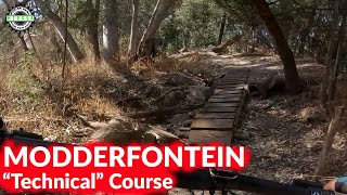
Popular Modderfontein Mountain Biking Trails
• 85 ★ 5.0 • 4,081 ft • 88 ft • 248 •
Popular green difficulty singletrack. This multi-use trail can be used one direction and has a easy overall physical rating with a 88 ft green climb. Trail visibility is always easy to follow. On average it takes 4 minutes to complete this trail.
• 90 ★ 5.0 • 1,135 ft • 20 ft • 247 •
Popular green difficulty singletrack. This multi-use trail can be used one direction and has a easy overall physical rating with a 20 ft green climb. Trail visibility is always easy to follow. On average it takes minutes to complete this trail.
• 85 ★ 5.0 • 2,067 ft • 32 ft • 236 •
Popular blue difficulty singletrack. This multi-use trail can be used one direction and has a moderate overall physical rating with a 32 ft blue climb. Trail visibility is always easy to follow. On average it takes 1 minutes to complete this trail.
• 100 ★ 5.0 • 1 mile • 121 ft • 229 •
Popular blue difficulty singletrack. This multi-use trail can be used one direction and has a moderate overall physical rating with a 121 ft blue climb. Trail visibility is always easy to follow. On average it takes 8 minutes to complete this trail.
• 80 ★ 5.0 • 3,766 ft • 89 ft • 225 •
Popular green difficulty singletrack. This multi-use trail can be used one direction and has a easy overall physical rating with a 89 ft green climb. Trail visibility is always easy to follow. On average it takes 4 minutes to complete this trail.
• 100 ★ 5.0 • 2,884 ft • 46 ft • 199 •
Popular blue difficulty singletrack. This multi-use trail can be used one direction and has a moderate overall physical rating with a 46 ft blue climb. Trail visibility is always easy to follow. On average it takes minutes to complete this trail.
• 5 ★ 5.0 • 0 ft • 0 ft • 180 •
Less popular green difficulty singletrack. This mountain bike primary trail can be used one direction and has a easy overall physical rating with a 0 ft green climb. Trail visibility is always easy to follow. On average it takes minutes to complete this trail.
• 100 ★ 0.0 • 728 ft • 43 ft • 171 •
Singletrack from bridge to tar road climb.
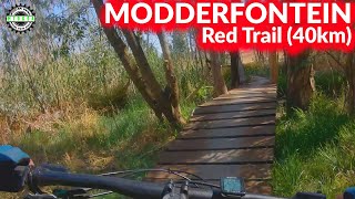
Modderfontein Mountain Bike Routes
Taroko Green Route Featured
★ 3.4 • 19 miles • 1,917 ft • 28 • Loop •
This intermediate route includes most of the best that Taroko has to offer.
★ 4.0 • 22 miles • 2,335 ft • 32 • Loop •
Yellow Route of +-36km incorporating all the single track riding available
• 23 miles • 2,601 ft • 39 •
• 20 miles • 2,032 ft • 38 •
• 20 miles • 2,036 ft • 35 •
• 8 miles • 808 ft • 0 •
Photos of Modderfontein Mountain Bike
Videos of Modderfontein Mountain Bike
8:09 |
927 |
Mar 29, 2021
15:49 |
1957 |
Mar 29, 2021

3:38 |
727 |
Mar 29, 2021
0:08 |
350 |
Mar 29, 2021
Recent Trail Reports
Activity Feed
| username | action | type | title | date |
|---|---|---|---|---|
| Traviss4GFlk | wishlist | route | activity #94424355 | May 10, 2026 @ 7:20am May 10, 2026 |
| KumerensYz1hp | wishlist | region | activity #93034968 | Apr 20, 2026 @ 12:43pm Apr 20, 2026 |
| Ewanf91rZb | ridden | trail | activity #88258644 | Feb 3, 2026 @ 12:25am Feb 3, 2026 |
| jd-shred | add | report | activity #86076003 and 4 more | Dec 26, 2025 @ 3:50am Dec 26, 2025 |
| jd-shred | add | report | activity #83036360 and 19 more | Oct 26, 2025 @ 2:31am Oct 26, 2025 |
Recent Comments
| username | type | title | comment | date |
|---|---|---|---|---|
| trail | Excellent | Feb 10, 2024 @ 12:38am Feb 10, 2024 | ||
| report | The wall of pain lives on... | Aug 2, 2022 @ 9:08am Aug 2, 2022 | ||
| report | Please do not update the trail course on the... | Jul 21, 2021 @ 1:15pm Jul 21, 2021 |
Local Badges
-

10 Blue Trails115 awarded -

Epic Mountain Bike Climb 2k3 awarded -

Climbing 10k Badge24 awarded -

Mountain Biking 100k Badge2 awarded -

Epic Ride Descent 2k3 awarded -

Descent 10k Badge24 awarded
Activity Type Stats
| activitytype | trails | distance | descent | descent distance | total vertical | rating | global rank | state rank | photos | reports | routes | ridelogs |
|---|---|---|---|---|---|---|---|---|---|---|---|---|
| Mountain Bike | 102 | 38 miles | 3,494 ft | 16 miles | 397 ft | #912 | #21 | 75 | 748 | 2 | 4,538 | |
| E-Bike | 106 | 38 miles | 3,494 ft | 16 miles | 397 ft | #909 | #64 | 710 | 2 | 459 | ||
| Hike | 89 | 30 miles | 1,969 ft | 10 miles | 390 ft | #1,801 | #49 | 724 | 44 | |||
| Trail Running | 89 | 30 miles | 1,969 ft | 10 miles | 390 ft | #1,290 | #45 | 724 | 338 |
Frequently Asked Questions About Modderfontein
▼
What are the best places to ride in Modderfontein?
Modderfontein has 1 areas to explore for mountain biking. The top rated areas are:
▼
What are the highest rated mountain biking trails in Modderfontein?
The highest rated mountain biking trails in Modderfontein are:
- TTP - Singletrack Bridge (4.2/5)
- TTP - Up The Creek (4.2/5)
- TTP - Singletrack 004 (4.2/5)
- TTP - Singletrack 006 (4.2/5)
- TTP - Singletrack 014 (4.2/5)
▼
What is the best time of the year to ride in Modderfontein?
Based on ride log data, the most popular months to ride in Modderfontein are:
- June (16 activities)
- July (13 activities)
- September (10 activities)
▼
Where can I park to ride in Modderfontein?
There are 1 parking locations listed in Modderfontein. The most popular parking spots are:
Activities
Trails
- By WillieJacobsz
 Trailforks SBP SWW & contributors
 - Admins: Gauteng, Gauteng
- #34097 - 28,370 views
- modderfontein activity log | embed map of Modderfontein mountain bike trails | modderfontein mountain biking points of interest
Downloading of trail gps tracks in kml & gpx formats is enabled for Modderfontein.
You must login to download files.