close
-
Layers w
- Weather Layers
- Pro
- Pro
- Pro
- Pro
- Pro
- Pro
- More Layers
- Pro
- Pro
- Pro
- Pro
-
Upgrade to

3D
Trail Conditions
- Unknown
- Snow Groomed
- Snow Packed
- Snow Covered
- Snow Cover Partial
- Freeze/thaw Cycle
- Icy
- Prevalent Mud
- Wet
- Variable
- Ideal
- Dry
- Very Dry
Trail Flow (Ridden Direction)
Trailforks scans users ridelogs to determine the most popular direction each trail is ridden. A good flowing trail network will have most trails flowing in a single direction according to their intension.
The colour categories are based on what percentage of riders are riding a trail in its intended direction.
The colour categories are based on what percentage of riders are riding a trail in its intended direction.
- > 96%
- > 90%
- > 80%
- > 70%
- > 50%
- < 50%
- bi-directional trail
- no data
Trail Last Ridden
Trailforks scans ridelogs to determine the last time a trail was ridden.
- < 2 days
- < 1 week
- < 2 weeks
- < 1 month
- < 6 months
- > 6 months
Trail Ridden Direction
The intended direction a trail should be ridden.
- Downhill Only
- Downhill Primary
- Both Directions
- Uphill Primary
- Uphill Only
- One Direction
Contribute Details
Colors indicate trail is missing specified detail.
- Description
- Photos
- Description & Photos
- Videos
Trail Popularity ?
Trailforks scans ridelogs to determine which trails are ridden the most in the last 9 months.
Trails are compared with nearby trails in the same city region with a possible 25 colour shades.
Think of this as a heatmap, more rides = more kinetic energy = warmer colors.
- most popular
- popular
- less popular
- not popular
ATV/ORV/OHV Filter
Max Vehicle Width
inches
US Cell Coverage
Legend

Radar Time
Activity Recordings
Trailforks uses anonymized public activity data.
?
Activity Recordings
Trailforks uses anonymized public activity data.
?
Personal Heatmap
▶
Activity Types
all
/
none
▶
Options
2
Date range
month
–
Winter Trails
Warning
A routing network for winter maps does not exist. Selecting trails using the winter trails layer has been disabled.
Missing Trails
Most Popular
Least Popular
Trails are colored based on popularity. The more popular a trail is, the more red. Less popular trails trend towards green.
Jump Magnitude Heatmap
Heatmap of where riders jump on trails. Zoom in to see individual jumps, click circles to view jump details.
BC Backroad Status
![map legend]()
Service Road Atlas is a free to use, community-driven service for viewing and creating reports on the numerous back-country service roads around B.C. and Alberta.

Slope Aspect
Direction the slope faces
Trails Deemphasized
Trails are shown in grey.
Only show trails with no bike usage.
Suggested Layers
Based on selected activity type
Save the current map location and zoom level as your default home location whenever this page is loaded.
Save
No description for Molveno has been added yet!
Login or register to submit one.
This region uses the Uk/Euro style trail grading system.
Activities Click to view
- Mountain Bike
25 trails
- E-Bike
21 trails
- Gravel Bike
0 trails
- Adaptive Bike
0 trails
- Winter Fat Bike
0 trails
- Hike
20 trails
- Trail Running
20 trails
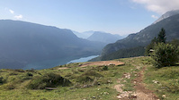
Region Details
- 12
- 4
- 4
- 3
Region Status
Open as of Jun 15, 2026Stats
- Avg Trail Rating
- Trails (view details)
- 30
- Trails Mountain Bike
- 25
- Trails E-Bike
- 21
- Trails Hike
- 20
- Trails Trail Running
- 20
- Trails Dirtbike/Moto
- 1
- Total Distance
- 47 miles
- Total Descent
- 13,892 ft
- Total Vertical
- 6,200 ft
- Highest Trailhead
- 7,482 ft
- Reports
- 378
- Photos
- 83
- Ridden Counter
- 11,047
Sub Regions
-
Molveno Zone
- 3
- 4
Popular Molveno Mountain Biking Trails
• 100 ★ 4.7 • 1 mile • 11 ft • 1,961 •
An intermediate flow trail that can be funny for all riders, from beginner to pro!
• 95 ★ 3.7 • 1 mile • 42 ft • 1,659 •
With his 2 km long is the easiest Flow Trail in Dolomiti Paganella Bike Area. It is designed to maximise fun and to learn the basic downhill riding skills: You can experience singletrails style sections and parabolic curve flow trail...
• 80 ★ 4.4 • 2,966 ft • 10 ft • 1,326 •
Highly rated popular blue difficulty singletrack. This mountain bike primary trail can be used downhill primary. On average it takes 4 minutes to complete this trail.
• 90 ★ 4.5 • 1 mile • 0 ft • 762 •
At the end of you have two choice the or the , both of the they will bring you back to Molveno area. The is slower and technical. The is super fast and well done with all the turn are parabolic so this will let the track be really flow...
• 95 ★ 5.0 • 1,037 ft • 35 ft • 396 •
Short easy trail connecting Blade Runner to Ude's Trail.
• 55 ★ 0.0 • 1 mile • 37 ft • 69 •
Easy trail down the north side of Mt. Ranzo, ending at Passo San Giovanni.
• 40 ★ 5.0 • 1 mile • 12 ft • 40 •
This beautiful forest trail is mostly moderate and flowy through the forest with a few steep and exposed sections as well as a few tight turns. It ends at a forest road which can be followed for a short way until the trail continues off...
• 60 ★ 4.4 • 2 miles • 132 ft • 30 •
Lovely natural forest trail starting at Passo San Giovanni. The trail is barely ever used. Mostly moderate forest terrain but deserves a black rating due to the exposure in the middle when the trail crosses extremely steep forest...
Molveno Mountain Bike Routes
Photos of Molveno Mountain Bike
Videos of Molveno Mountain Bike
trail: Big Hero
0:11 |
50 |
Sep 23, 2019
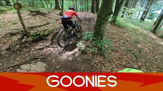
youtuber
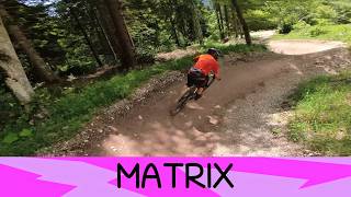
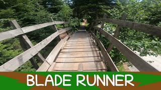
![Blade Runner - Molveno 7/6/26]()
trail: Blade Runner
3:58 |
11 |
Jun 11, 2026 , Molveno
youtuber
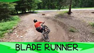
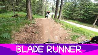
![MTB Dolomiti Paganella Molveno zone Bike...]()
trail: Blade Runner
4:03 |
9 |
Jun 8, 2026 , Molveno
youtuber
![MTB Dolomiti Paganella Molveno zone Bike...]()
trail: Blade Runner
3:49 |
8 |
Jun 8, 2026 , Molveno
Recent Trail Reports
| status | trail | date | condition | info | user |
|---|---|---|---|---|---|
| Matrix | Jun 15, 2026 @ 5:53pm (Europe/Vaduz) Jun 15, 2026 | Ideal | pinkknip | ||
| Goonies | Jun 15, 2026 @ 5:53pm (Europe/Vaduz) Jun 15, 2026 | Ideal | pinkknip | ||
| Blade Runner | Jun 6, 2026 @ 8:28am (Europe/Vaduz) Jun 5, 2026 | Ideal | matherj | ||
| Big Hero | Jun 6, 2026 @ 8:28am (Europe/Vaduz) Jun 5, 2026 | Ideal | matherj | ||
| Pradel - Tovre | Jun 6, 2026 @ 8:28am (Europe/Vaduz) Jun 5, 2026 | Ideal | matherj | ||
| 612 La Venus Upper | May 30, 2026 @ 9:19am (Europe/Vaduz) May 30, 2026 | Variable | vAtWFt | ||
| Molveno - Pradel | Apr 11, 2026 @ 9:10am (Europe/Rome) Apr 11, 2026 | Ideal | Ciacerela | ||
| Malga Andalo Access 1 | Sep 13, 2025 @ 3:03pm (Europe/Vaduz) Sep 13, 2025 | Unknown | giova83 | ||
| Mt. Ranzo North | Oct 19, 2025 @ 8:23am (Europe/Rome) Oct 18, 2025 | Ideal | meliobike | ||
| 644 La Mars | Sep 12, 2025 @ 2:58pm (Europe/Rome) Sep 12, 2025 | Unknown | JakaN89 |
Activity Feed
| username | action | type | title | date |
|---|---|---|---|---|
| bikefreakobi | wishlist | trail | activity #97309592 | Jun 19, 2026 @ 5:24am 16 hours |
| Belle88 | wishlist | trail | activity #97308305 | Jun 19, 2026 @ 4:50am 17 hours |
| VERONICAIfGKUg | add | photo | activity #97306796 and 1 more | Jun 19, 2026 @ 4:07am 18 hours |
| Alexxx1 | vote | trail | activity #97120400 and 1 more | Jun 16, 2026 @ 10:16am Jun 16, 2026 |
| Alexxx1 | ridden | trail | activity #97120398 | Jun 16, 2026 @ 10:16am Jun 16, 2026 |
Recent Comments
| username | type | title | comment | date |
|---|---|---|---|---|
| trail | Very enjoyable legacy track that wasn’t too... | Oct 12, 2025 @ 5:17am Oct 12, 2025 | ||
| trail | Somebody got paid to build this? 🤯 awkward... | Oct 11, 2025 @ 6:09am Oct 11, 2025 | ||
| trail | Easy peasy trail with a view, great for... | Aug 19, 2025 @ 11:26pm Aug 19, 2025 | ||
| trail | Lovely flow trail, fast, sometimes tight, but... | Aug 19, 2025 @ 11:22pm Aug 19, 2025 | ||
| trail | Great flow trail, and a lot better maintained... | Aug 19, 2025 @ 11:21pm Aug 19, 2025 |
Local Badges
-

Epic Mountain Bike Climb 2k1,036 awarded -

Climbing 10k Badge87 awarded -

Mountain Biking 100k Badge1 awarded -

Epic Ride Descent 2k1,037 awarded -

Descent 10k Badge145 awarded -

Descent 100k Badge2 awarded
Bike & Skill Parks
| name | type | city | rating |
|---|---|---|---|
| Molveno Zone | bike park | Molveno |
Activity Type Stats
| activitytype | trails | distance | descent | descent distance | total vertical | rating | global rank | state rank | photos | reports | routes | ridelogs |
|---|---|---|---|---|---|---|---|---|---|---|---|---|
| Mountain Bike | 25 | 44 miles | 12,178 ft | 18 miles | 5,459 ft | #1,911 | #75 | 83 | 378 | 1 | 2,752 | |
| E-Bike | 21 | 40 miles | 10,728 ft | 16 miles | 5,459 ft | #588 | #65 | 348 | 590 | |||
| Hike | 20 | 31 miles | 8,337 ft | 10 miles | 6,201 ft | #4,088 | #158 | 352 | 701 | |||
| Trail Running | 20 | 31 miles | 8,337 ft | 10 miles | 6,201 ft | #3,662 | #142 | 352 | 182 | |||
| Dirtbike/Moto | 1 | 2,933 ft | 308 ft | 49 ft | 22 |
Frequently Asked Questions About Molveno
▼
What are the best places to ride in Molveno?
Molveno has 1 areas to explore for mountain biking. The top rated areas are:
▼
What are the highest rated mountain biking trails in Molveno?
The highest rated mountain biking trails in Molveno are:
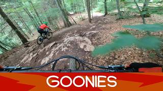
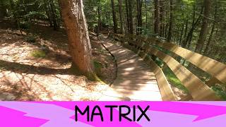
- Blade Runner (4.6/5)
- Matrix (4.3/5)
- Goonies (4.3/5)
- Ude's Connector (4.2/5)
- Croz del Pegolotti (4.2/5)
▼
What is the best time of the year to ride in Molveno?
Based on ride log data, the most popular months to ride in Molveno are:
- July (25 activities)
- August (23 activities)
- September (19 activities)
▼
Where can I park to ride in Molveno?
There are 1 parking locations listed in Molveno. The most popular parking spots are:
Activities
Trails
- By denitopia
 TRAILFORKS VTA & contributors
 - Admins: caval, larry81541, micheletraversi
- #11803 - 13,020 views
- molveno activity log | embed map of Molveno mountain bike trails | molveno mountain biking points of interest
Downloading of trail gps tracks in kml & gpx formats is enabled for Molveno.
You must login to download files.