close
-
Layers w
- Weather Layers
- Pro
- Pro
- Pro
- Pro
- Pro
- Pro
- More Layers
- Pro
- Pro
- Pro
- Pro
-
Upgrade to

3D
Trail Conditions
- Unknown
- Snow Groomed
- Snow Packed
- Snow Covered
- Snow Cover Partial
- Freeze/thaw Cycle
- Icy
- Prevalent Mud
- Wet
- Variable
- Ideal
- Dry
- Very Dry
Trail Flow (Ridden Direction)
Trailforks scans users ridelogs to determine the most popular direction each trail is ridden. A good flowing trail network will have most trails flowing in a single direction according to their intension.
The colour categories are based on what percentage of riders are riding a trail in its intended direction.
The colour categories are based on what percentage of riders are riding a trail in its intended direction.
- > 96%
- > 90%
- > 80%
- > 70%
- > 50%
- < 50%
- bi-directional trail
- no data
Trail Last Ridden
Trailforks scans ridelogs to determine the last time a trail was ridden.
- < 2 days
- < 1 week
- < 2 weeks
- < 1 month
- < 6 months
- > 6 months
Trail Ridden Direction
The intended direction a trail should be ridden.
- Downhill Only
- Downhill Primary
- Both Directions
- Uphill Primary
- Uphill Only
- One Direction
Contribute Details
Colors indicate trail is missing specified detail.
- Description
- Photos
- Description & Photos
- Videos
Trail Popularity ?
Trailforks scans ridelogs to determine which trails are ridden the most in the last 9 months.
Trails are compared with nearby trails in the same city region with a possible 25 colour shades.
Think of this as a heatmap, more rides = more kinetic energy = warmer colors.
- most popular
- popular
- less popular
- not popular
ATV/ORV/OHV Filter
Max Vehicle Width
inches
US Cell Coverage
Legend

Radar Time
Activity Recordings
Trailforks uses anonymized public activity data.
?
Activity Recordings
Trailforks uses anonymized public activity data.
?
Personal Heatmap
▶
Activity Types
all
/
none
▶
Options
2
Date range
month
–
Winter Trails
Warning
A routing network for winter maps does not exist. Selecting trails using the winter trails layer has been disabled.
Missing Trails
Most Popular
Least Popular
Trails are colored based on popularity. The more popular a trail is, the more red. Less popular trails trend towards green.
Jump Magnitude Heatmap
Heatmap of where riders jump on trails. Zoom in to see individual jumps, click circles to view jump details.
BC Backroad Status
![map legend]()
Service Road Atlas is a free to use, community-driven service for viewing and creating reports on the numerous back-country service roads around B.C. and Alberta.

Slope Aspect
Direction the slope faces
Trails Deemphasized
Trails are shown in grey.
Only show trails with no bike usage.
Suggested Layers
Based on selected activity type
Save the current map location and zoom level as your default home location whenever this page is loaded.
Save
No description for Moncton has been added yet!
Login or register to submit one.
Activities Click to view
- Mountain Bike
79 trails
- E-Bike
11 trails
- Gravel Bike
0 trails
- Adaptive Bike
0 trails
- Winter Fat Bike
0 trails
- Horse
4 trails
- Hike
83 trails
- Trail Running
81 trails
- Dirtbike/Moto
1 trails
- ATV/ORV/OHV
7 trails
- Snowmobile
5 trails
- Snowshoe
10 trails
- Nordic Ski
20 trails
Region Details
- 9
- 15
- 45
- 8
Region Status
Open as of Jun 15, 2026Stats
- Avg Trail Rating
- Trails (view details)
- 77
- Trails Mountain Bike
- 79
- Trails E-Bike
- 11
- Trails Horse
- 4
- Trails Hike
- 83
- Trails Trail Running
- 81
- Trails Dirtbike/Moto
- 1
- Trails ATV/ORV/OHV
- 7
- Trails Snowmobile
- 5
- Trails Snowshoe
- 10
- Trails Nordic Ski
- 20
- Total Distance
- 56 miles
- Total Descent
- 4,841 ft
- Total Vertical
- 587 ft
- Highest Trailhead
- 607 ft
- Reports
- 315
- Photos
- 87
- Ridden Counter
- 5,589
Sub Regions
-
Centennial Park
- 2
- 8
-
Connaught Woods / Hall's Creek
- 1
- 3
-
Dieppe Rotary Park
- 18
- 14
- 3
-
Humphrey Brook
- 2
- 14
- 1
-
Irishtown Nature Park
- 6
- 4
-
Mapleton Park
- 7
- 10
-
Mill Creek Nature Park
- 12
-
Moncton Riverfront
- 1
Popular Moncton Mountain Biking Trails
• 100 ★ 5.0 • 643 ft • 0 ft • 304 •
Popular blue difficulty singletrack. This mountain bike primary trail and has a easy overall physical rating with a 0 ft blue climb. On average it takes minutes to complete this trail.
• 100 ★ 5.0 • 440 ft • 0 ft • 299 •
Popular blue difficulty singletrack. This mountain bike primary trail and has a easy overall physical rating with a 0 ft blue climb. On average it takes minutes to complete this trail.
• 100 ★ 5.0 • 764 ft • 6 ft • 294 •
Popular green difficulty singletrack. This mountain bike primary trail and has a easy overall physical rating with a 6 ft green climb. It features a-frame, berm, bridge, drop, jump, gap jump, ladder bridge, log ride, pump track, rock face, rock garden, roller coaster, skinny, teeter totter, wallride and other. Trail visibility is always easy to follow. On average it takes 1 minutes to complete this trail.
• 100 ★ 5.0 • 505 ft • 0 ft • 290 •
Popular green difficulty singletrack. This mountain bike primary trail and has a easy overall physical rating with a 0 ft green climb. On average it takes minutes to complete this trail.
• 100 ★ 5.0 • 883 ft • 30 ft • 288 •
Popular green difficulty singletrack. This mountain bike primary trail and has a easy overall physical rating with a 30 ft green climb. On average it takes minutes to complete this trail.
• 100 ★ 5.0 • 646 ft • 19 ft • 282 •
Popular blue difficulty singletrack. This mountain bike primary trail with a 19 ft blue climb. On average it takes 1 minutes to complete this trail.
• 95 ★ 5.0 • 623 ft • 9 ft • 270 •
Popular green difficulty singletrack. This mountain bike primary trail and has a easy overall physical rating with a 9 ft green climb. On average it takes minutes to complete this trail.
• 95 ★ 5.0 • 1,900 ft • 11 ft • 266 •
Popular blue difficulty singletrack. This mountain bike primary trail and has a moderate overall physical rating with a 11 ft blue climb. It features berm and bridge. On average it takes 3 minutes to complete this trail.
Moncton Mountain Bike Routes
★ 5.0 • 19 miles • 322 ft • 0 • Point to Point •
1090703 9of12 NB - 07c Moncton, NB to Shédiac, NB (South Cove Camping and Golf) 30km
4 miles • 110 ft • 4 •
Fun and Easy trail for mountain bikes. You will be sharing this trail with walkers so please keep that in...
2 miles • 75 ft • 8 • Loop • Race •
Adults race starts at 7h00 row call 6h50
4,764 ft • 43 ft • 2 • Loop • Race •
U9 & U11 race lap race start 6h10 row call 6h00
1 mile • 65 ft • 5 • Loop • Race •
U13 & U15 race course row call 6h15 race start at 6h25 race duration should be around 20 min
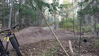
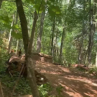
Photos of Moncton Mountain Bike
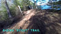
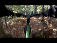
Videos of Moncton Mountain Bike

trail: Dieppe BMX Track
0:16 |
169 |
Jan 30, 2022
trail: Les Sapins
0:13 |
176 |
Apr 26, 2021
trail: Baille-Y-Ca
0:05 |
249 |
Apr 21, 2021
trail: John Howard
8:59 |
195 |
Apr 23, 2020
trail: Connaught Woods
7:21 |
833 |
Oct 7, 2015

4:45 |
116 |
Jul 15, 2024
trail: Martre
2:21 |
135 |
Oct 2, 2023 , Moncton

trail: Colvert
5:34 |
94 |
Oct 2, 2023 , Moncton
Recent Trail Reports
| status | trail | date | condition | info | user |
|---|---|---|---|---|---|
| Entrance/Exit | Jun 9, 2026 @ 6:57pm (America/Moncton) Jun 9, 2026 | Ideal | Sebastien685 | ||
| Rotary Single Track 6-B | Jun 9, 2026 @ 6:57pm (America/Moncton) Jun 9, 2026 | Ideal | Sebastien685 | ||
| Le Jeffrey | Jun 9, 2026 @ 6:57pm (America/Moncton) Jun 9, 2026 | Ideal | Sebastien685 | ||
| Dynamite | Jun 9, 2026 @ 6:57pm (America/Moncton) Jun 9, 2026 | Ideal | Sebastien685 | ||
| la Connector | Jun 9, 2026 @ 6:57pm (America/Moncton) Jun 9, 2026 | Ideal | Sebastien685 | ||
| Raddler | Jun 9, 2026 @ 6:57pm (America/Moncton) Jun 9, 2026 | Ideal | Sebastien685 | ||
| La Tour d'Eau | Jun 9, 2026 @ 6:57pm (America/Moncton) Jun 9, 2026 | Ideal | Sebastien685 | ||
| Le Sprockids | Jun 9, 2026 @ 6:57pm (America/Moncton) Jun 9, 2026 | Ideal | Sebastien685 | ||
| Stumps - Connector | May 26, 2026 @ 6:59pm (America/Moncton) May 26, 2026 | Ideal | Sebastien685 | ||
| RockGarden B-Line | May 26, 2026 @ 6:59pm (America/Moncton) May 26, 2026 | Ideal | Sebastien685 |
Activity Feed
| username | action | type | title | date |
|---|---|---|---|---|
| Williamarseneau19 | rsvp | event | activity #96817012 | Jun 12, 2026 @ 11:12am Jun 12, 2026 |
| Sebastien685 | vote | trail | activity #96668311 and 5 more | Jun 10, 2026 @ 6:23am Jun 10, 2026 |
| Sebastien685 | add | report | activity #96649231 and 14 more | Jun 9, 2026 @ 7:42pm Jun 9, 2026 |
| MARCrFNMIq | wishlist | trail | activity #96543789 | Jun 8, 2026 @ 9:10am Jun 8, 2026 |
| MARCrFNMIq | ridden | trail | activity #96543493 and 2 more | Jun 8, 2026 @ 9:05am Jun 8, 2026 |
Recent Comments
| username | type | title | comment | date |
|---|---|---|---|---|
| trail | This parh got a good potential to be a black... | Dec 7, 2025 @ 6:08pm Dec 7, 2025 | ||
| trail | Hiden trail good for practicing xc race just... | Oct 26, 2025 @ 5:29pm Oct 26, 2025 | ||
| trail | lots of roots and half rideable trails. would... | May 17, 2023 @ 8:56am May 17, 2023 | ||
| trail | i live in the area and dint know about any... | Apr 4, 2023 @ 10:01am Apr 4, 2023 | ||
| report | Fat Biking. TRAILS Scout: clear & hard... | Jan 22, 2023 @ 4:43am Jan 22, 2023 |
Local Badges
-

10 Green Trails115 awarded -

Epic Ride Climb 2k0 awarded -

Climbing 10k Badge23 awarded -

Climbing 100k Badge0 awarded -

Epic Ride Descent 2k0 awarded -

Descent 10k Badge23 awarded
Activity Type Stats
| activitytype | trails | distance | descent | descent distance | total vertical | rating | global rank | state rank | photos | reports | routes | ridelogs |
|---|---|---|---|---|---|---|---|---|---|---|---|---|
| Mountain Bike | 79 | 56 miles | 4,839 ft | 19 miles | 587 ft | #781 | #2 | 82 | 315 | 18 | 12,147 | |
| E-Bike | 11 | 11 miles | 594 ft | 4 miles | 568 ft | #4,740 | #7 | 266 | 1 | 224 | ||
| Horse | 4 | 3 miles | 43 ft | 3,409 ft | 279 ft | #1,788 | #2 | 45 | 1 | |||
| Hike | 83 | 55 miles | 4,806 ft | 19 miles | 587 ft | #3,544 | #7 | 5 | 315 | 544 | ||
| Trail Running | 81 | 54 miles | 4,541 ft | 18 miles | 587 ft | #2,952 | #3 | 315 | 1 | 1,404 | ||
| Dirtbike/Moto | 1 | 453 ft | 39 ft | #896 | #2 | 45 | 7 | |||||
| ATV/ORV/OHV | 7 | 4 miles | 75 ft | 1 mile | 531 ft | #636 | #2 | 45 | 2 | |||
| Snowmobile | 5 | 3 miles | 59 ft | 4,793 ft | 89 ft | #214 | #2 | 7 | ||||
| Snowshoe | 10 | 6 miles | 72 ft | 1 mile | 312 ft | #749 | #4 | 9 | 62 | |||
| Nordic Ski | 20 | 17 miles | 1,886 ft | 6 miles | 220 ft | #675 | #2 | 14 | 434 |
Frequently Asked Questions About Moncton
▼
What are the best places to ride in Moncton?
Moncton has 7 areas to explore for mountain biking. The top rated areas are:
▼
What are the highest rated mountain biking trails in Moncton?
The highest rated mountain biking trails in Moncton are:
- Cascade (4.4/5)
- Connaught Woods (4.2/5)
- Raddler (4.1/5)
- La Tour d'Eau (4.1/5)
- la Connector (4.1/5)
▼
What is the best time of the year to ride in Moncton?
Based on ride log data, the most popular months to ride in Moncton are:
- July (139 activities)
- August (130 activities)
- September (93 activities)
▼
Where can I park to ride in Moncton?
There are 17 parking locations listed in Moncton. The most popular parking spots are: View all parking and trailhead locations on the map to plan your visit.
Activities
Trails
Points of Interest
- By alexisberube RVC & contributors
- Admins: CCT
- #8568 - 33,195 views
- moncton activity log | embed map of Moncton mountain bike trails | moncton mountain biking points of interest
Downloading of trail gps tracks in kml & gpx formats is enabled for Moncton.
You must login to download files.