close
-
Layers w
- Weather Layers
- Pro
- Pro
- Pro
- Pro
- Pro
- Pro
- More Layers
- Pro
- Pro
- Pro
- Pro
-
Upgrade to

3D
Trail Conditions
- Unknown
- Snow Groomed
- Snow Packed
- Snow Covered
- Snow Cover Partial
- Freeze/thaw Cycle
- Icy
- Prevalent Mud
- Wet
- Variable
- Ideal
- Dry
- Very Dry
Trail Flow (Ridden Direction)
Trailforks scans users ridelogs to determine the most popular direction each trail is ridden. A good flowing trail network will have most trails flowing in a single direction according to their intension.
The colour categories are based on what percentage of riders are riding a trail in its intended direction.
The colour categories are based on what percentage of riders are riding a trail in its intended direction.
- > 96%
- > 90%
- > 80%
- > 70%
- > 50%
- < 50%
- bi-directional trail
- no data
Trail Last Ridden
Trailforks scans ridelogs to determine the last time a trail was ridden.
- < 2 days
- < 1 week
- < 2 weeks
- < 1 month
- < 6 months
- > 6 months
Trail Ridden Direction
The intended direction a trail should be ridden.
- Downhill Only
- Downhill Primary
- Both Directions
- Uphill Primary
- Uphill Only
- One Direction
Contribute Details
Colors indicate trail is missing specified detail.
- Description
- Photos
- Description & Photos
- Videos
Trail Popularity ?
Trailforks scans ridelogs to determine which trails are ridden the most in the last 9 months.
Trails are compared with nearby trails in the same city region with a possible 25 colour shades.
Think of this as a heatmap, more rides = more kinetic energy = warmer colors.
- most popular
- popular
- less popular
- not popular
ATV/ORV/OHV Filter
Max Vehicle Width
inches
US Cell Coverage
Legend

Radar Time
Activity Recordings
Trailforks uses anonymized public activity data.
?
Activity Recordings
Trailforks uses anonymized public activity data.
?
Personal Heatmap
▶
Activity Types
all
/
none
▶
Options
2
Date range
month
–
Winter Trails
Warning
A routing network for winter maps does not exist. Selecting trails using the winter trails layer has been disabled.
Missing Trails
Most Popular
Least Popular
Trails are colored based on popularity. The more popular a trail is, the more red. Less popular trails trend towards green.
Jump Magnitude Heatmap
Heatmap of where riders jump on trails. Zoom in to see individual jumps, click circles to view jump details.
BC Backroad Status
![map legend]()
Service Road Atlas is a free to use, community-driven service for viewing and creating reports on the numerous back-country service roads around B.C. and Alberta.

Slope Aspect
Direction the slope faces
Trails Deemphasized
Trails are shown in grey.
Only show trails with no bike usage.
Suggested Layers
Based on selected activity type
Save the current map location and zoom level as your default home location whenever this page is loaded.
SaveBreve e comoda salita per strada sterrata facente parte della Linea Cadorna.
Alcune belle discese preparate per le bici.
Alcune belle discese preparate per le bici.
This region uses the Uk/Euro style trail grading system.
Activities Click to view
- Mountain Bike
6 trails
- E-Bike
5 trails
- Horse
0 trails
- Hike
3 trails
- Trail Running
3 trails
Region Details
- 2
- 3
Region Status
Caution as of May 9, 2026Stats
- Avg Trail Rating
- Trails (view details)
- 6
- Trails Mountain Bike
- 6
- Trails E-Bike
- 5
- Trails Hike
- 3
- Trails Trail Running
- 3
- Total Distance
- 4 miles
- Total Descent Distance
- 2 miles
- Total Descent
- 1,911 ft
- Total Vertical
- 841 ft
- Highest Trailhead
- 2,183 ft
- Reports
- 53
- Photos
- 2
- Ridden Counter
- 143
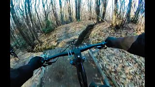
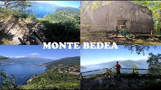
Popular Monte Bedea Mountain Biking Trails
• 100 ★ 5.0 • 1 mile • 0 ft • 40 •
Bellissima discesa realizzata per le bici ma molto naturale. Sentiero stretto a volte in lieve contropendenza e con qualche breve ripido. Un paio di gap jump per saltare via delle trincee sono evitabili per chicken line a sinistra....
• 5 ★ 0.0 • 3,432 ft • 6 ft • 12 •
Inizialmente single track su terreno compatto con qualche radice e pietra smossa, poi mulattiera con pietre smosse e qualche facile rock garden.
Monte Bedea Mountain Bike Routes
18 miles • 3,117 ft • 10 • Loop •
Questo giro permette di collegare alcuni dei più bei sentieri dell'area di Agra, Dumenza e del Monte...
Videos of Monte Bedea Mountain Bike
trail: Saltafoss
10:03 |
302 |
Mar 1, 2023 , Agra - Dumenza
trail: Monte Bedea - Il Valdo
8:31 |
533 |
Aug 19, 2020 , Agra - Dumenza

trail: Salita al Monte Bedea
8:31 |
374 |
Aug 19, 2020 , Agra - Dumenza
Recent Trail Reports
| status | trail | date | condition | info | user |
|---|---|---|---|---|---|
| Salita al Monte Bedea | May 9, 2026 @ 7:42pm (Europe/Rome) May 9, 2026 | Ideal | vega10 | ||
| Saltafoss | Apr 19, 2026 @ 4:09pm (Europe/Rome) Apr 19, 2026 | Wet | StefanoTWTOCw | ||
| Monte Bedea - Il Valdo | Apr 19, 2026 @ 4:06pm (Europe/Rome) Apr 19, 2026 | Ideal | StefanoTWTOCw | ||
| La Ripida | Apr 19, 2026 @ 4:06pm (Europe/Rome) Apr 19, 2026 | Ideal | StefanoTWTOCw | ||
| Link Roggiolo - Bedea | Apr 4, 2026 @ 2:24pm (Europe/Vaduz) Apr 4, 2026 | Ideal | Giorgio1973 |
Activity Feed
| username | action | type | title | date |
|---|---|---|---|---|
| EmanueleegX0Q | ridden | trail | activity #95556594 | May 26, 2026 @ 5:00am May 26, 2026 |
| EmanueleegX0Q | ridden | trail | activity #95547489 and 1 more | May 26, 2026 @ 12:35am May 26, 2026 |
| pit907 | add | trail | activity #95304633 | May 23, 2026 @ 4:35am May 23, 2026 |
| Stefanof2Io9R | ridden | trail | activity #94578898 and 3 more | May 12, 2026 @ 12:52pm May 12, 2026 |
| vega10 | add | report | activity #94358137 | May 9, 2026 @ 10:42am May 9, 2026 |
Recent Comments
| username | type | title | comment | date |
|---|---|---|---|---|
| trail | Trail costruito molto divertente. Non è mai... | Apr 19, 2026 @ 7:42am Apr 19, 2026 | ||
| trail | Il Trail è davvero molto bello, divertente e... | Apr 19, 2026 @ 7:39am Apr 19, 2026 | ||
| trail | Fra i Trail del Bedea, è sicuramente il più... | Apr 19, 2026 @ 7:34am Apr 19, 2026 | ||
| trail | Molto bello, drop di diverse dimensioni e... | Apr 5, 2026 @ 10:29am Apr 5, 2026 | ||
| trail | Ottimo sentiero con diversi elementi e alcuni... | Apr 5, 2026 @ 10:28am Apr 5, 2026 |
Nearby Areas
| name | distance | ||||
|---|---|---|---|---|---|
| Monte Lema | 2 | 12 | 3.4 km | ||
| Monte Pian Nave | 9 | 3 | 1 | 3.5 km | |
| Monte Mondini | 5 | 7 | 4 km | ||
| Sette Termini | 5 | 12 | 1 | 4.3 km | |
| Val Veddasca | 4.5 km |
Activity Type Stats
| activitytype | trails | distance | descent | descent distance | total vertical | rating | global rank | state rank | photos | reports | routes | ridelogs |
|---|---|---|---|---|---|---|---|---|---|---|---|---|
| Mountain Bike | 6 | 4 miles | 1,913 ft | 2 miles | 840 ft | #9,332 | #468 | 2 | 53 | 1 | 96 | |
| E-Bike | 5 | 4 miles | 1,913 ft | 2 miles | 840 ft | #7,934 | #537 | 51 | 1 | 60 | ||
| Hike | 3 | 2 miles | 509 ft | 3,379 ft | 840 ft | #16,509 | #573 | 37 | ||||
| Trail Running | 3 | 2 miles | 509 ft | 3,379 ft | 840 ft | #15,260 | #562 | 37 | 1 |
Frequently Asked Questions About Monte Bedea
▼
What are the highest rated mountain biking trails in Monte Bedea?
The highest rated mountain biking trails in Monte Bedea are:
- Saltafoss (4.2/5)
- La Ripida (0/5)
- Monte Bedea - Il Valdo (0/5)
▼
Where can I park to ride in Monte Bedea?
Check the Monte Bedea trail map for trailhead and parking information. Community members regularly update access and parking details for trails in the area.
▼
What is the longest trail in Monte Bedea?
The longest trail in Monte Bedea is Saltafoss at 1.2 miles. View all trails sorted by distance.
▼
How many trails are in Monte Bedea?
Monte Bedea has a total of 6 trails. Browse top mountain biking trails in Monte Bedea to find detailed information including difficulty ratings, distances, and trail conditions.
- By adessoomaipiu
 & contributors
 - Admins: adessoomaipiu
- #52126 - 1,698 views
- monte bedea activity log | embed map of Monte Bedea mountain bike trails |
Downloading of trail gps tracks in kml & gpx formats is enabled for Monte Bedea.
You must login to download files.