close
-
Layers w
- Weather Layers
- Pro
- Pro
- Pro
- Pro
- Pro
- Pro
- More Layers
- Pro
- Pro
- Pro
- Pro
-
Upgrade to

3D
Trail Conditions
- Unknown
- Snow Groomed
- Snow Packed
- Snow Covered
- Snow Cover Partial
- Freeze/thaw Cycle
- Icy
- Prevalent Mud
- Wet
- Variable
- Ideal
- Dry
- Very Dry
Trail Flow (Ridden Direction)
Trailforks scans users ridelogs to determine the most popular direction each trail is ridden. A good flowing trail network will have most trails flowing in a single direction according to their intension.
The colour categories are based on what percentage of riders are riding a trail in its intended direction.
The colour categories are based on what percentage of riders are riding a trail in its intended direction.
- > 96%
- > 90%
- > 80%
- > 70%
- > 50%
- < 50%
- bi-directional trail
- no data
Trail Last Ridden
Trailforks scans ridelogs to determine the last time a trail was ridden.
- < 2 days
- < 1 week
- < 2 weeks
- < 1 month
- < 6 months
- > 6 months
Trail Ridden Direction
The intended direction a trail should be ridden.
- Downhill Only
- Downhill Primary
- Both Directions
- Uphill Primary
- Uphill Only
- One Direction
Contribute Details
Colors indicate trail is missing specified detail.
- Description
- Photos
- Description & Photos
- Videos
Trail Popularity ?
Trailforks scans ridelogs to determine which trails are ridden the most in the last 9 months.
Trails are compared with nearby trails in the same city region with a possible 25 colour shades.
Think of this as a heatmap, more rides = more kinetic energy = warmer colors.
- most popular
- popular
- less popular
- not popular
ATV/ORV/OHV Filter
Max Vehicle Width
inches
US Cell Coverage
Legend

Radar Time
Activity Recordings
Trailforks uses anonymized public activity data.
?
Activity Recordings
Trailforks uses anonymized public activity data.
?
Personal Heatmap
▶
Activity Types
all
/
none
▶
Options
2
Date range
month
–
Winter Trails
Warning
A routing network for winter maps does not exist. Selecting trails using the winter trails layer has been disabled.
Missing Trails
Most Popular
Least Popular
Trails are colored based on popularity. The more popular a trail is, the more red. Less popular trails trend towards green.
Jump Magnitude Heatmap
Heatmap of where riders jump on trails. Zoom in to see individual jumps, click circles to view jump details.
BC Backroad Status
![map legend]()
Service Road Atlas is a free to use, community-driven service for viewing and creating reports on the numerous back-country service roads around B.C. and Alberta.

Slope Aspect
Direction the slope faces
Trails Deemphasized
Trails are shown in grey.
Only show trails with no bike usage.
Suggested Layers
Based on selected activity type
Save the current map location and zoom level as your default home location whenever this page is loaded.
Save
No description for Monteriggioni has been added yet!
Login or register to submit one.
This region uses the Uk/Euro style trail grading system.
Activities Click to view
- Mountain Bike
24 trails
- E-Bike
4 trails
- Adaptive Bike
0 trails
- Winter Fat Bike
0 trails
- Hike
21 trails
- Trail Running
21 trails
- Dirtbike/Moto
0 trails
Region Details
- 3
- 2
- 8
- 9
Region Status
Caution as of Sep 3, 2025Stats
- Avg Trail Rating
- Trails (view details)
- 24
- Trails Mountain Bike
- 24
- Trails E-Bike
- 4
- Trails Hike
- 21
- Trails Trail Running
- 21
- Total Distance
- 40 miles
- Total Descent
- 10,486 ft
- Total Vertical
- 1,599 ft
- Highest Trailhead
- 2,025 ft
- Reports
- 145
- Photos
- 34
- Ridden Counter
- 1,215
Popular Monteriggioni Mountain Biking Trails
• 90 ★ 5.0 • 2 miles • 298 ft • 207 •
This cross country trail is a segment of the world famous Via Francigena (VF) historical pilgrimage pathway. (see website link below) This segment contains a mixture of dirt and gravel surfaces, and follows city streets for a few blocks...
• 80 ★ 5.0 • 2 miles • 314 ft • 171 •
This cross country trail is a segment of the world famous Via Francigena (VF) historical pilgrimage pathway. (see website link below) This segment contains a mixture of dirt surfaces and gravel surfaces through a forested area....
• 60 ★ 0.0 • 5 miles • 958 ft • 40 •
This cross country trail is a segment of the world famous Via Francigena (VF) historical pilgrimage pathway. (see website link below) This segment contains a mixture of dirt, gravel surfaces, through both forest and agricultural lands,...
• 70 ★ 4.0 • 5 miles • 397 ft • 37 •
This cross country trail is a segment of the world famous Via Francigena (VF) historical pilgrimage pathway. (see website link below) This segment contains a mixture of dirt and gravel surfaces passing through both agricultural land and...
• 100 ★ 5.0 • 2,416 ft • 30 ft • 36 •
Popular blue difficulty singletrack. This mountain bike primary trail can be used downhill primary and has a moderate overall physical rating with a 30 ft blue climb. It features drop, jump and other. Trail visibility is always easy to follow. On average it takes 3 minutes to complete this trail.
• 40 ★ 5.0 • 2,257 ft • 0 ft • 35 •
Moderately popular blue difficulty singletrack. This mountain bike primary trail can be used downhill only and has a moderate overall physical rating with a 0 ft blue climb. It features other. Trail visibility is always easy to follow. On average it takes 4 minutes to complete this trail.
• 70 ★ 4.4 • 3,727 ft • 0 ft • 29 •
Popular blue difficulty singletrack. This mountain bike primary trail can be used downhill only and has a moderate overall physical rating with a 0 ft blue climb. On average it takes 5 minutes to complete this trail.
Monteriggioni Mountain Bike Routes
35 miles • 4,577 ft • 1 • Out & Back •
La gara, patrocinata dal Comune di Monteriggioni e dalla Provincia di Siena, in collaborazione con la...
5 miles • 948 ft • 0 • Point to Point •
This cross country trail is a segment of the world famous Via Francigena (VF) historical pilgrimage...
• 31 miles • 4,763 ft • 1 •
• 30 miles • 4,669 ft • 1 •
• 31 miles • 4,704 ft • 1 •
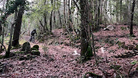
Photos of Monteriggioni Mountain Bike
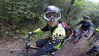
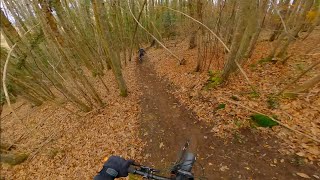
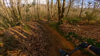
Videos of Monteriggioni Mountain Bike
trail: Nonnaccio
0:07 |
187 |
Jan 19, 2020
trail: La Mangiatoia
4:35 |
307 |
May 1, 2016
youtuber
![Porcino + Labucaseca - Montagnola Senese]()
trail: Labucaseca
3:22 |
82 |
Feb 6, 2025 , Monteriggioni
Recent Trail Reports
| status | trail | date | condition | info | user |
|---|---|---|---|---|---|
| M E F I S T O | Sep 3, 2025 @ 9:13am Sep 3, 2025 | Ideal | Lukyluke76 | ||
| Labucaseca | Aug 31, 2025 @ 3:43pm Aug 31, 2025 | Ideal | Ivanca | ||
| Nonnaccio | Aug 31, 2025 @ 3:43pm Aug 31, 2025 | Ideal | Ivanca | ||
| Viperone | Dec 22, 2024 @ 10:20am Dec 22, 2024 | Ideal | elbafreeride | ||
| La Mangiatoia | Sep 7, 2024 @ 4:09pm Sep 7, 2024 | Dry | Ivanca | ||
| El Cabron | Sep 7, 2024 @ 4:09pm Sep 7, 2024 | Dry | Ivanca | ||
| La polemica | Jul 25, 2024 @ 11:55pm Jul 25, 2024 | Dry | FG5REgn | ||
| Gracciano to Abbadia a Isola - Via Francigena | Mar 8, 2024 @ 12:25am Mar 8, 2024 | Variable | Fiore13 | ||
| Abbadia a Isola Uphill | Dec 23, 2023 @ 1:53am Dec 23, 2023 | Ideal | elbafreeride | ||
| Strada di Certino Ridgeline | Mar 19, 2023 @ 2:21am Mar 19, 2023 | Ideal | biagia |
Activity Feed
| username | action | type | title | date |
|---|---|---|---|---|
| qTppQa | comment | trail | activity #94510604 | May 11, 2026 @ 12:22pm May 11, 2026 |
| ronca89 | ridden | trail | activity #92062225 | Apr 6, 2026 @ 10:05am Apr 6, 2026 |
| Sprordie | difficultyvote | trail | activity #90975002 | Mar 21, 2026 @ 4:53am Mar 21, 2026 |
| Fedeciapi | wishlist | trail | activity #90515500 | Mar 13, 2026 @ 3:24pm Mar 13, 2026 |
| Lukyluke76 | ridden | trail | activity #86576989 | Jan 3, 2026 @ 10:20am Jan 3, 2026 |
Recent Comments
| username | type | title | comment | date |
|---|---|---|---|---|
| trail | Fatto oggi, era un po’ bagnato e non si... | May 11, 2026 @ 12:22pm May 11, 2026 | ||
| report | Primo tratto in discesa inagibile,scavato dai... | Apr 19, 2022 @ 4:19am Apr 19, 2022 | ||
| trail | In | Apr 19, 2021 @ 12:50pm Apr 19, 2021 | ||
| trail | Buone condizioni, spostato qualche sasso. | Jul 29, 2020 @ 9:13am Jul 29, 2020 | ||
| trail | Sentiero molto facile e poco pendente. Ottimo... | Oct 20, 2019 @ 1:11pm Oct 20, 2019 |
Local Badges
-

Epic Ride Climb 2k232 awarded -

Climbing 10k Badge42 awarded -

Climbing 100k Badge8 awarded -

Epic Ride Descent 2k232 awarded -

Descent 10k Badge42 awarded -

Descent 100k Badge8 awarded
Activity Type Stats
| activitytype | trails | distance | descent | descent distance | total vertical | rating | global rank | state rank | photos | reports | routes | ridelogs |
|---|---|---|---|---|---|---|---|---|---|---|---|---|
| Mountain Bike | 24 | 40 miles | 10,486 ft | 21 miles | 1,598 ft | #2,982 | #146 | 34 | 145 | 2 | 6,520 | |
| E-Bike | 4 | 3 miles | 1,184 ft | 1 mile | 764 ft | #7,559 | #824 | 125 | 1 | 711 | ||
| Hike | 21 | 36 miles | 8,615 ft | 18 miles | 1,598 ft | #5,893 | #289 | 143 | 181 | |||
| Trail Running | 21 | 36 miles | 8,615 ft | 18 miles | 1,598 ft | #5,336 | #264 | 143 | 34 |
Frequently Asked Questions About Monteriggioni
▼
What are the highest rated mountain biking trails in Monteriggioni?
The highest rated mountain biking trails in Monteriggioni are:
- La Mangiatoia (4.3/5)
- Quartaia to Gracciano - Via Francigena (4.1/5)
- Nonnaccio (4.1/5)
- Labucaseca (4.1/5)
- Viperone (4.1/5)
▼
What is the best time of the year to ride in Monteriggioni?
Based on ride log data, the most popular months to ride in Monteriggioni are:
- May (17 activities)
- October (8 activities)
- February (6 activities)
▼
Where can I park to ride in Monteriggioni?
Check the Monteriggioni trail map for trailhead and parking information. Community members regularly update access and parking details for trails in the area.
▼
What is the longest trail in Monteriggioni?
The longest trail in Monteriggioni is Coneo to Santa Lucia - Via Francigena at 5.1 miles. View all trails sorted by distance.
Activities
Trails
Points of Interest
- By cheorch
 & contributors
 - Admins: DanielePracchia
- #9466 - 3,788 views
- monteriggioni activity log | embed map of Monteriggioni mountain bike trails |
Downloading of trail gps tracks in kml & gpx formats is enabled for Monteriggioni.
You must login to download files.