close
-
Layers w
- Weather Layers
- Pro
- Pro
- Pro
- Pro
- Pro
- Pro
- More Layers
- Pro
- Pro
- Pro
- Pro
-
Upgrade to

3D
Trail Conditions
- Unknown
- Snow Groomed
- Snow Packed
- Snow Covered
- Snow Cover Partial
- Freeze/thaw Cycle
- Icy
- Prevalent Mud
- Wet
- Variable
- Ideal
- Dry
- Very Dry
Trail Flow (Ridden Direction)
Trailforks scans users ridelogs to determine the most popular direction each trail is ridden. A good flowing trail network will have most trails flowing in a single direction according to their intension.
The colour categories are based on what percentage of riders are riding a trail in its intended direction.
The colour categories are based on what percentage of riders are riding a trail in its intended direction.
- > 96%
- > 90%
- > 80%
- > 70%
- > 50%
- < 50%
- bi-directional trail
- no data
Trail Last Ridden
Trailforks scans ridelogs to determine the last time a trail was ridden.
- < 2 days
- < 1 week
- < 2 weeks
- < 1 month
- < 6 months
- > 6 months
Trail Ridden Direction
The intended direction a trail should be ridden.
- Downhill Only
- Downhill Primary
- Both Directions
- Uphill Primary
- Uphill Only
- One Direction
Contribute Details
Colors indicate trail is missing specified detail.
- Description
- Photos
- Description & Photos
- Videos
Trail Popularity ?
Trailforks scans ridelogs to determine which trails are ridden the most in the last 9 months.
Trails are compared with nearby trails in the same city region with a possible 25 colour shades.
Think of this as a heatmap, more rides = more kinetic energy = warmer colors.
- most popular
- popular
- less popular
- not popular
ATV/ORV/OHV Filter
Max Vehicle Width
inches
US Cell Coverage
Legend

Radar Time
Activity Recordings
Trailforks uses anonymized public activity data.
?
Activity Recordings
Trailforks uses anonymized public activity data.
?
Personal Heatmap
▶
Activity Types
all
/
none
▶
Options
2
Date range
month
–
Winter Trails
Warning
A routing network for winter maps does not exist. Selecting trails using the winter trails layer has been disabled.
Missing Trails
Most Popular
Least Popular
Trails are colored based on popularity. The more popular a trail is, the more red. Less popular trails trend towards green.
Jump Magnitude Heatmap
Heatmap of where riders jump on trails. Zoom in to see individual jumps, click circles to view jump details.
BC Backroad Status
![map legend]()
Service Road Atlas is a free to use, community-driven service for viewing and creating reports on the numerous back-country service roads around B.C. and Alberta.

Slope Aspect
Direction the slope faces
Trails Deemphasized
Trails are shown in grey.
Only show trails with no bike usage.
Suggested Layers
Based on selected activity type
Save the current map location and zoom level as your default home location whenever this page is loaded.
Save
No description for Montesano has been added yet!
Login or register to submit one.
Activities Click to view
- Mountain Bike
96 trails
- E-Bike
21 trails
- Gravel Bike
0 trails
- Adaptive Bike
0 trails
- Winter Fat Bike
0 trails
- Horse
10 trails
- Hike
97 trails
- Trail Running
95 trails
- Dirtbike/Moto
7 trails
- Observed Trials
4 trails
- ATV/ORV/OHV
6 trails
Region Details
- 36
- 11
- 38
- 8
- 1
Region Status
Open as of Mar 23, 2026Stats
- Avg Trail Rating
- Trails (view details)
- 97
- Trails Mountain Bike
- 96
- Trails E-Bike
- 21
- Trails Horse
- 10
- Trails Hike
- 97
- Trails Trail Running
- 95
- Trails Dirtbike/Moto
- 7
- Trails Observed Trials
- 4
- Trails ATV/ORV/OHV
- 6
- Trails Snowshoe
- 2
- Trails Backcountry Ski
- 2
- Total Distance
- 117 miles
- Total Descent
- 22,431 ft
- Total Vertical
- 4,700 ft
- Highest Trailhead
- 4,726 ft
- Reports
- 3,174
- Photos
- 443
- Ridden Counter
- 5,036
Sub Regions
-
Montesano City Forest
- 8
- 36
- 7
- 1
-
Wynoochee Lake
- 3
- 2
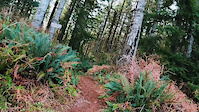
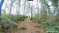
Popular Montesano Mountain Biking Trails
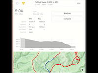
• 75 ★ 4.0 • 2,244 ft • 0 ft • 137 •
This is the start of the climb up from Lk. Sylvia to the , A-B, and other trails that loop back to Sylvia Creek.
• 95 ★ 4.2 • 4,006 ft • 124 ft • 133 •
I think this is the classic Montesano trail. Natural terrain, narrow trail bed but open views. Good in both directions going to or coming from the other trails in the system. Come up the , PineWinder, or the . Great end to a ride from...
• 100 ★ 4.6 • 1,234 ft • 0 ft • 115 •
Nice little addition to trails that spur off of the Sylvia Ridge Trail. This one has a few smaller drops, some stump jumps and a small gap jump. All jumps are optional with ride arounds.
• 100 ★ 5.0 • 1,013 ft • 16 ft • 102 •
Popular green difficulty singletrack. This mountain bike primary trail can be used downhill primary and has a easy overall physical rating with a 16 ft green climb. On average it takes 1 minutes to complete this trail.
• 100 ★ 4.3 • 2,805 ft • 7 ft • 101 •
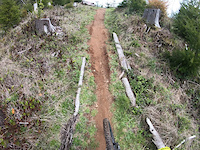
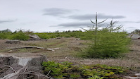
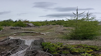
After the clear cut the contractors worked with us to clear an upper route that connects with the A-B Trail. The new routing should be good once we get some rain and pack the dirt in. There will be some good sweepers and intermediate drops.
• 95 ★ 4.4 • 1,205 ft • 17 ft • 99 •
We're on a roll! We had to grub out the clear cut to clear the old trails. So why not grub a new one in? It's just a collection of rolls and sweeping turns with one small drop into a left climb. Once it packs in it should be fun.
• 85 ★ 4.4 • 2,522 ft • 66 ft • 92 •
Popular blue difficulty singletrack. This mountain bike primary trail can be used both directions and has a moderate overall physical rating with a 66 ft blue climb. On average it takes 10 minutes to complete this trail.
• 100 ★ 4.8 • 1,836 ft • 46 ft • 89 •
This is the first portion of a trail that is a work in progress to lessen the amount of gravel time spent traversing to/from the outer reaches of the City Forest. Particularly between Sylvia Ridge and X720 Trails. This is a traverse...
Photos of Montesano Mountain Bike
Videos of Montesano Mountain Bike
trail: Neapolitan Charlie
0:40 |
28 |
Feb 11, 2024
trail: Hot Tomato
0:06 |
115 |
May 8, 2023
trail: Geronimo
0:21 |
46 |
Apr 15, 2023
trail: Geronimo
0:19 |
24 |
Apr 15, 2023
trail: Hop 'N Drop
0:51 |
70 |
Apr 12, 2023
trail: Sergeant Meowenstein
5:31 |
46 |
Jul 25, 2021

trail: Snake Oil
4:45 |
84 |
Mar 17, 2021
trail: Serpent's Tail
2:47 |
93 |
Mar 12, 2021
Recent Trail Reports
Activity Feed
| username | action | type | title | date |
|---|---|---|---|---|
| amtnbiker | wishlist | region | activity #97354093 | Jun 19, 2026 @ 4:56pm 2 days |
| PeterMarkdrQSMH | wishlist | region | activity #96337450 | Jun 5, 2026 @ 7:11pm Jun 5, 2026 |
| jonathanlars | ridden | trail | activity #95691289 | May 28, 2026 @ 12:53am May 28, 2026 |
| JonwCwN25 | wishlist | region | activity #95687472 | May 27, 2026 @ 10:47pm May 27, 2026 |
| n97240 | wishlist | region | activity #95463799 | May 24, 2026 @ 8:26pm May 24, 2026 |
Recent Comments
| username | type | title | comment | date |
|---|---|---|---|---|
| report | Awesome!!! | Jun 28, 2025 @ 7:01pm Jun 28, 2025 | ||
| trail | This trail leaves Coho Campground and is in... | Aug 27, 2024 @ 8:52pm Aug 27, 2024 | ||
| trail | Trail is open and has been for some time. May... | Dec 15, 2023 @ 6:25am Dec 15, 2023 | ||
| trail | The upper portion of this trail, above... | Sep 18, 2023 @ 8:08pm Sep 18, 2023 | ||
| report | Sounds good. Thanks. Hopefully you got out and... | Sep 10, 2023 @ 7:30am Sep 10, 2023 |
Local Badges
-

10 Blue Trails54 awarded -

Epic Ride Climb 2k24 awarded -

Climbing 10k Badge20 awarded -

Climbing 100k Badge4 awarded -

Epic Ride Descent 2k24 awarded -

Descent 10k Badge19 awarded
Activity Type Stats
| activitytype | trails | distance | descent | descent distance | total vertical | rating | global rank | state rank | photos | reports | routes | ridelogs |
|---|---|---|---|---|---|---|---|---|---|---|---|---|
| Mountain Bike | 96 | 113 miles | 22,041 ft | 56 miles | 3,625 ft | #1,260 | #485 | 370 | 3,174 | 5,619 | ||
| E-Bike | 21 | 61 miles | 8,868 ft | 29 miles | 3,589 ft | #2,891 | #1,093 | 2,855 | 324 | |||
| Horse | 10 | 43 miles | 6,542 ft | 21 miles | 3,114 ft | #1,339 | #808 | 764 | ||||
| Hike | 97 | 117 miles | 21,759 ft | 56 miles | 4,701 ft | #1,328 | #606 | 50 | 3,138 | 396 | ||
| Trail Running | 95 | 113 miles | 21,424 ft | 56 miles | 3,625 ft | #1,699 | #572 | 4 | 3,137 | 208 | ||
| Dirtbike/Moto | 7 | 32 miles | 3,520 ft | 14 miles | 2,913 ft | #850 | #308 | 751 | 6 | |||
| Observed Trials | 4 | 3 miles | 358 ft | 1 mile | 2,356 ft | #238 | #55 | 8 | ||||
| ATV/ORV/OHV | 6 | 15 miles | 922 ft | 6 miles | 2,356 ft | #802 | #356 | 4 | 751 | 3 | ||
| Snowshoe | 2 | 3 miles | 338 ft | 4,616 ft | 1,483 ft | 5 | ||||||
| Backcountry Ski | 2 | 3 miles | 338 ft | 4,616 ft | 1,483 ft | 1 |
Frequently Asked Questions About Montesano
▼
What are the best places to ride in Montesano?
Montesano has 2 areas to explore for mountain biking. The top rated areas are:
▼
What are the highest rated mountain biking trails in Montesano?
The highest rated mountain biking trails in Montesano are:
- Dirty Peanut (4.4/5)
- Aunt Bethany (4.4/5)
- Geronimo (4.3/5)
- Joel's Trail (4.3/5)
- Neapolitan Charlie (4.3/5)
▼
What is the best time of the year to ride in Montesano?
Based on ride log data, the most popular months to ride in Montesano are:
- July (98 activities)
- August (86 activities)
- April (67 activities)
▼
Where can I park to ride in Montesano?
There are 7 parking locations listed in Montesano. The most popular parking spots are: View all parking and trailhead locations on the map to plan your visit.
Activities
Trails
Points of Interest
- Comfy Couch Viewpoint
- She's a Butte Falls Sight
- Satsop Valley and Nuke Towers Viewpoint
- Chehalis Valley and Nuke Towers Viewpoint
- Information Station
- Campbell Tree Grove Campground Camping
- Coho Campground Camping
- Maidenhair Falls Sight
- Chetwood Camp Camping
- Other [watercrossing]
- Anderson Butte (3,268 ft)
- By LanceGT4
 & contributors
 - Admins: MTBMontesano, EMBA-WS
- #7560 - 7,975 views
- montesano activity log | embed map of Montesano mountain bike trails | montesano mountain biking points of interest
Downloading of trail gps tracks in kml & gpx formats is enabled for Montesano.
You must login to download files.