close
-
Layers w
- Weather Layers
- Pro
- Pro
- Pro
- Pro
- Pro
- Pro
- More Layers
- Pro
- Pro
- Pro
- Pro
-
Upgrade to

3D
Trail Conditions
- Unknown
- Snow Groomed
- Snow Packed
- Snow Covered
- Snow Cover Partial
- Freeze/thaw Cycle
- Icy
- Prevalent Mud
- Wet
- Variable
- Ideal
- Dry
- Very Dry
Trail Flow (Ridden Direction)
Trailforks scans users ridelogs to determine the most popular direction each trail is ridden. A good flowing trail network will have most trails flowing in a single direction according to their intension.
The colour categories are based on what percentage of riders are riding a trail in its intended direction.
The colour categories are based on what percentage of riders are riding a trail in its intended direction.
- > 96%
- > 90%
- > 80%
- > 70%
- > 50%
- < 50%
- bi-directional trail
- no data
Trail Last Ridden
Trailforks scans ridelogs to determine the last time a trail was ridden.
- < 2 days
- < 1 week
- < 2 weeks
- < 1 month
- < 6 months
- > 6 months
Trail Ridden Direction
The intended direction a trail should be ridden.
- Downhill Only
- Downhill Primary
- Both Directions
- Uphill Primary
- Uphill Only
- One Direction
Contribute Details
Colors indicate trail is missing specified detail.
- Description
- Photos
- Description & Photos
- Videos
Trail Popularity ?
Trailforks scans ridelogs to determine which trails are ridden the most in the last 9 months.
Trails are compared with nearby trails in the same city region with a possible 25 colour shades.
Think of this as a heatmap, more rides = more kinetic energy = warmer colors.
- most popular
- popular
- less popular
- not popular
ATV/ORV/OHV Filter
Max Vehicle Width
inches
US Cell Coverage
Legend

Radar Time
Activity Recordings
Trailforks uses anonymized public activity data.
?
Activity Recordings
Trailforks uses anonymized public activity data.
?
Personal Heatmap
▶
Activity Types
all
/
none
▶
Options
2
Date range
month
–
Winter Trails
Warning
A routing network for winter maps does not exist. Selecting trails using the winter trails layer has been disabled.
Missing Trails
Most Popular
Least Popular
Trails are colored based on popularity. The more popular a trail is, the more red. Less popular trails trend towards green.
Jump Magnitude Heatmap
Heatmap of where riders jump on trails. Zoom in to see individual jumps, click circles to view jump details.
BC Backroad Status
![map legend]()
Service Road Atlas is a free to use, community-driven service for viewing and creating reports on the numerous back-country service roads around B.C. and Alberta.

Slope Aspect
Direction the slope faces
Trails Deemphasized
Trails are shown in grey.
Only show trails with no bike usage.
Suggested Layers
Based on selected activity type
Save the current map location and zoom level as your default home location whenever this page is loaded.
Save
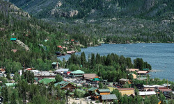
No description for Montpelier has been added yet!
Login or register to submit one.
Activities Click to view
- Mountain Bike
54 trails
- E-Bike
25 trails
- Gravel Bike
0 trails
- Adaptive Bike
0 trails
- Horse
9 trails
- Hike
55 trails
- Trail Running
55 trails
- Dirtbike/Moto
99 trails
- Observed Trials
10 trails
- ATV/ORV/OHV
69 trails
Region Details
- 19
- 7
- 16
- 7
Region Status
Caution as of Jun 7, 2026Local Trail Association
Stats
- Avg Trail Rating
- Trails (view details)
- 106
- Trails Mountain Bike
- 54
- Trails E-Bike
- 25
- Trails Horse
- 9
- Trails Hike
- 55
- Trails Trail Running
- 55
- Trails Dirtbike/Moto
- 99
- Trails Observed Trials
- 10
- Trails ATV/ORV/OHV
- 69
- Trails Nordic Ski
- 1
- Total Distance
- 246 miles
- Total Descent
- 60,953 ft
- Total Vertical
- 4,432 ft
- Highest Trailhead
- 9,701 ft
- Reports
- 43
- Photos
- 71
- Ridden Counter
- 802
Articles
Lesser-Known Lake Escapes in the U.S.
May 22, 2025 from outsideonline.com
From turquoise gems in the Rockies to forest-fringed glacial lakes in New England, escape the crowds at these nine lakes in the U.S. where...
Sub Regions
-
Bear Lake
- 1
- 1
-
St Charles Canyon
- 11
- 5
Popular Montpelier Mountain Biking Trails
• 95 ★ 4.0 • 4 miles • 1,673 ft • 74 •
This trail is a lesser known gem. Plenty of smooth and wide open stretches to let the brakes go and catch some air over the little mounds. There are several technical rock sections, both short ones and longer more difficult ones. Every...
• 95 ★ 0.0 • 2 miles • 0 ft • 43 •
Popular blue difficulty dirt/gravel road. This multi-use trail can be used both directions. On average it takes 19 minutes to complete this trail.
• 90 ★ 5.0 • 1 mile • 10 ft • 42 •
A fun short singletrack section around the meadow. It has a few techy sections in it but is mostly fast and smooth with very little elevation change.
• 60 ★ 3.5 • 3 miles • 94 ft • 21 •
There are two options of dropping in. 1- Stay high and right in order to get a very steep and loose drop in. 2- Take the first hairpin on the left to wind around the trees, avoid the steep entrance. The rest of the trail offers some...
• 5 ★ 4.0 • 5 miles • 773 ft • 13 •
This section of the offers loads of loose rock with more rock sticking out everywhere just for good measure. You will find a handful of smoother-smooth sections to offer relief. Depending on the direction (North or South) that you head...
• 5 ★ 0.0 • 3,655 ft • 0 ft • 10 •
Short pack trail connecting the trail to the trailhead parking lot.
• 5 ★ 4.0 • 2 miles • 37 ft • 9 • • moto
Predominantly a dirt bike trail that ties in to connector routes onto the .
Montpelier Mountain Bike Routes
6 miles • 460 ft • 3 • Shuttled •
This is used by horses more then bikes. Start near the Bloomington Lake parking lot. Ride (or push your...
13 miles • 1,552 ft • 1 • Loop •
Ride up Dry Canyon and down Davis Canyon. This is a loop.
• 11 miles • 2,082 ft • 2 •
Photos of Montpelier Mountain Bike
Videos of Montpelier Mountain Bike
trail: Midnight Mountain
23:11 |
60 |
Jul 28, 2025 , Montpelier
Recent Trail Reports
| status | trail | date | condition | info | user |
|---|---|---|---|---|---|
| Guacamole Trail | Jun 7, 2026 @ 11:16pm (America/Boise) Jun 7, 2026 | Dry | dtshredzmtb | ||
| Coyote Gap | Jun 7, 2026 @ 11:11pm (America/Boise) Jun 7, 2026 | Dry | dtshredzmtb | ||
| North Fork St. Charles | Aug 23, 2025 @ 10:53am Aug 23, 2025 | Very Dry | dibbsafi | ||
| Snowslide | Sep 13, 2023 @ 8:12am Sep 13, 2023 | Dry | Erick-Russon | ||
| Ranger Dip | Jul 27, 2023 @ 8:15pm Jul 27, 2023 | Dry | birdrider | ||
| Davis Canyon | Jun 19, 2022 @ 4:56pm Jun 19, 2022 | Ideal | qm7 | ||
| Red Sinks | Mar 28, 2021 @ 11:03am Mar 28, 2021 | Snow Groomed | radmande1 | ||
| High Line (Gibson Basin) | Sep 12, 2018 @ 8:35pm Sep 12, 2018 | Very Dry | Pivot5-5 | ||
| Minnetonka Cave Path | Jul 9, 2017 @ 3:01pm Jul 9, 2017 | Dry | dvbwn | ||
| Highline | Jul 5, 2017 @ 1:03pm Jul 5, 2017 | Variable | trevordbee |
National Scenic Trails & Official Routes
-
Great Western Trail
- Mountain Bike
- E-Bike
- Horse
- Hike
- Trail Running
- Dirtbike/Moto
- ATV/ORV/OHV

Activity Feed
| username | action | type | title | date |
|---|---|---|---|---|
| dtshredzmtb | checkin | trail | activity #96521186 | Jun 7, 2026 @ 10:18pm Jun 7, 2026 |
| dtshredzmtb | add | report | activity #96521165 | Jun 7, 2026 @ 10:16pm Jun 7, 2026 |
| dtshredzmtb | add | report | activity #96521114 | Jun 7, 2026 @ 10:14pm Jun 7, 2026 |
| chuckm911 | ridden | trail | activity #96063345 | Jun 1, 2026 @ 10:38pm Jun 1, 2026 |
| mtnmort | wishlist | trail | activity #94955910 | May 17, 2026 @ 7:13pm May 17, 2026 |
Recent Comments
| username | type | title | comment | date |
|---|---|---|---|---|
| trail | It says both directions, but if you are on a... | Jul 4, 2020 @ 4:29pm Jul 4, 2020 |
Local Badges
-

Epic Ride Climb 2k44 awarded -

Climbing 10k Badge2 awarded -

Climbing 100k Badge0 awarded -

Epic Ride Descent 2k30 awarded -

Descent 10k Badge2 awarded -

Descent 100k Badge0 awarded
Activity Type Stats
| activitytype | trails | distance | descent | descent distance | total vertical | rating | global rank | state rank | photos | reports | routes | ridelogs |
|---|---|---|---|---|---|---|---|---|---|---|---|---|
| Mountain Bike | 54 | 121 miles | 23,087 ft | 52 miles | 4,203 ft | #2,506 | #901 | 65 | 42 | 2 | 1,368 | |
| E-Bike | 25 | 41 miles | 7,365 ft | 17 miles | 2,995 ft | #3,644 | #1,254 | 38 | 1 | 91 | ||
| Horse | 9 | 26 miles | 5,764 ft | 12 miles | 3,018 ft | #1,767 | #999 | 31 | ||||
| Hike | 55 | 121 miles | 23,153 ft | 52 miles | 4,203 ft | #2,235 | #907 | 42 | 1 | 292 | ||
| Trail Running | 55 | 121 miles | 23,153 ft | 52 miles | 4,203 ft | #1,834 | #608 | 42 | 1 | 40 | ||
| Dirtbike/Moto | 99 | 187 miles | 47,290 ft | 102 miles | 4,432 ft | #61 | #37 | 3 | 36 | 30 | ||
| Observed Trials | 10 | #288 | #79 | |||||||||
| ATV/ORV/OHV | 69 | 125 miles | 31,352 ft | 69 miles | 4,072 ft | #124 | #61 | 4 | 29 | 13 | ||
| Nordic Ski | 1 | #1,182 | #664 | 107 |
Frequently Asked Questions About Montpelier
▼
What are the best places to ride in Montpelier?
Montpelier has 2 areas to explore for mountain biking. The top rated areas are:
▼
What are the highest rated mountain biking trails in Montpelier?
The highest rated mountain biking trails in Montpelier are:
- Sink Hollow (4.1/5)
- Highline (4/5)
- Davis Canyon (4/5)
- North Fork St. Charles (3.9/5)
- Highline - Copenhagen to German Dugway (3.9/5)
▼
What is the best time of the year to ride in Montpelier?
Based on ride log data, the most popular months to ride in Montpelier are:
- July (24 activities)
- August (16 activities)
- September (10 activities)
▼
Where can I park to ride in Montpelier?
There are 2 parking locations listed in Montpelier. The most popular parking spots are:
Activities
Trails
- By xrayj35
 & contributors
 - Admins: chuktA, IdahoEnduroSeries, macgyver96, noplacefamous, jntidaho
- #6184 - 4,060 views
- montpelier activity log | embed map of Montpelier mountain bike trails | montpelier mountain biking points of interest
Downloading of trail gps tracks in kml & gpx formats is enabled for Montpelier.
You must login to download files.