close
-
Layers w
- Weather Layers
- Pro
- Pro
- Pro
- Pro
- Pro
- Pro
- More Layers
- Pro
- Pro
- Pro
- Pro
-
Upgrade to

3D
Trail Conditions
- Unknown
- Snow Groomed
- Snow Packed
- Snow Covered
- Snow Cover Partial
- Freeze/thaw Cycle
- Icy
- Prevalent Mud
- Wet
- Variable
- Ideal
- Dry
- Very Dry
Trail Flow (Ridden Direction)
Trailforks scans users ridelogs to determine the most popular direction each trail is ridden. A good flowing trail network will have most trails flowing in a single direction according to their intension.
The colour categories are based on what percentage of riders are riding a trail in its intended direction.
The colour categories are based on what percentage of riders are riding a trail in its intended direction.
- > 96%
- > 90%
- > 80%
- > 70%
- > 50%
- < 50%
- bi-directional trail
- no data
Trail Last Ridden
Trailforks scans ridelogs to determine the last time a trail was ridden.
- < 2 days
- < 1 week
- < 2 weeks
- < 1 month
- < 6 months
- > 6 months
Trail Ridden Direction
The intended direction a trail should be ridden.
- Downhill Only
- Downhill Primary
- Both Directions
- Uphill Primary
- Uphill Only
- One Direction
Contribute Details
Colors indicate trail is missing specified detail.
- Description
- Photos
- Description & Photos
- Videos
Trail Popularity ?
Trailforks scans ridelogs to determine which trails are ridden the most in the last 9 months.
Trails are compared with nearby trails in the same city region with a possible 25 colour shades.
Think of this as a heatmap, more rides = more kinetic energy = warmer colors.
- most popular
- popular
- less popular
- not popular
ATV/ORV/OHV Filter
Max Vehicle Width
inches
US Cell Coverage
Legend

Radar Time
Activity Recordings
Trailforks uses anonymized public activity data.
?
Activity Recordings
Trailforks uses anonymized public activity data.
?
Personal Heatmap
▶
Activity Types
all
/
none
▶
Options
2
Date range
month
–
Winter Trails
Warning
A routing network for winter maps does not exist. Selecting trails using the winter trails layer has been disabled.
Missing Trails
Most Popular
Least Popular
Trails are colored based on popularity. The more popular a trail is, the more red. Less popular trails trend towards green.
Jump Magnitude Heatmap
Heatmap of where riders jump on trails. Zoom in to see individual jumps, click circles to view jump details.
BC Backroad Status
![map legend]()
Service Road Atlas is a free to use, community-driven service for viewing and creating reports on the numerous back-country service roads around B.C. and Alberta.

Slope Aspect
Direction the slope faces
Trails Deemphasized
Trails are shown in grey.
Only show trails with no bike usage.
Suggested Layers
Based on selected activity type
Save the current map location and zoom level as your default home location whenever this page is loaded.
Save
No description for Monument has been added yet!
Login or register to submit one.
Activities Click to view
- Mountain Bike
89 trails
- Gravel Bike
0 trails
- Adaptive Bike
0 trails
- Winter Fat Bike
0 trails
- Horse
5 trails
- Hike
98 trails
- Trail Running
100 trails
Region Details
- 6
- 25
- 45
- 12
Region Status
Open as of Jun 4, 2026Stats
- Avg Trail Rating
- Trails (view details)
- 99
- Trails Mountain Bike
- 91
- Trails E-Bike
- 3
- Trails Horse
- 5
- Trails Hike
- 98
- Trails Trail Running
- 100
- Trails Snowshoe
- 2
- Trails Nordic Ski
- 2
- Total Distance
- 99 miles
- Total Descent
- 14,112 ft
- Total Vertical
- 2,462 ft
- Highest Trailhead
- 9,409 ft
- Reports
- 450
- Photos
- 99
- Ridden Counter
- 15,980
Sub Regions
-
Mount Herman
- 17
- 39
- 11
Popular Monument Mountain Biking Trails
• 100 ★ 4.4 • 4,040 ft • 139 ft • 611 •
Typically ridden as a cruise up towards the mountain. As you bike along you will come across a few sets of rocks that act like a small stair step in the initial part. There are small roots that can be ridden around further up the trail.
• 100 ★ 2.7 • 1,762 ft • 61 ft • 451 •
Slow, winding trail cross country trail that still beats taking the road.
• 100 ★ 4.5 • 1 mile • 262 ft • 412 •
Smooth ride up or down, one short rock "ramp" that can be an obstacle to some. Fast in downhill direction. Small section of loose rocks halfway up.
• 70 ★ 4.0 • 3,419 ft • 194 ft • 376 •
Woodland forest with embedded rocks and plenty of switchbacks. Surface is mildly loose when dry.
• 75 ★ 4.5 • 1 mile • 136 ft • 374 •
Typical forest floor. Stay on trail to avoid going to neighborhoods.
• 75 ★ 4.5 • 3,070 ft • 15 ft • 363 •
The upper portion of a popular hiking and biking trail. Fast with some technical sections. Be on the lookout for hikers and dogs. Trail typically will carry snow in some portions longer than other trails in the area because of shade.
Monument Mountain Bike Routes
6 miles • 1,994 ft • 3 •
Airplane ride - Swanks Trail proper (via the upper Palmer Res) to Elk Road, then to the Sydney Harrison Trail.
• 9 miles • 598 ft • 3 •
• 14 miles • 204 ft • 0 •
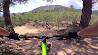
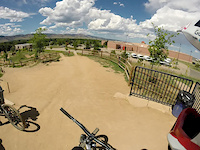
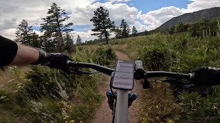
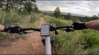
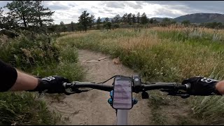
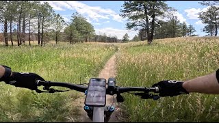
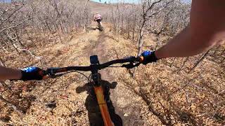
Photos of Monument Mountain Bike
Videos of Monument Mountain Bike
trail: Wishy Washy
0:42 |
78 |
Aug 17, 2020
trail: Kicker
2:01 |
281 |
Aug 18, 2014

trail: Kicker
0:50 |
2149 |
Feb 24, 2013
trail: Renegade
4:14 |
49 |
Aug 7, 2025 , Monument
trail: The Pipeline
2:05 |
45 |
Aug 5, 2025 , Monument
trail: Mad Hatter
4:17 |
48 |
Aug 4, 2025 , Monument
trail: Meadow
2:11 |
34 |
Aug 2, 2025 , Monument
trail: String Beans
6:30 |
71 |
Nov 17, 2024 , Monument
Recent Trail Reports
| status | trail | date | condition | info | user |
|---|---|---|---|---|---|
| Flow Dog | Apr 25, 2026 @ 4:16pm (America/Denver) Apr 25, 2026 | Dry | Dmac13 | ||
| 715 | Apr 25, 2026 @ 4:15pm (America/Denver) Apr 25, 2026 | Dry | Dmac13 | ||
| Cool Runnings | Apr 12, 2026 @ 10:41am (America/Denver) Apr 12, 2026 | Very Dry | ATK605 | ||
| Pick-Up Sticks | Mar 18, 2026 @ 4:42pm (America/Denver) Mar 18, 2026 | Unknown | afuellenbach FOMP | ||
| Flying Dog Connector | Mar 18, 2026 @ 4:42pm (America/Denver) Mar 18, 2026 | Dry | afuellenbach FOMP | ||
| Poky Oaks | Mar 18, 2026 @ 4:42pm (America/Denver) Mar 18, 2026 | Dry | afuellenbach FOMP | ||
| Here Kitty Kitty | Mar 18, 2026 @ 4:42pm (America/Denver) Mar 18, 2026 | Dry | afuellenbach FOMP | ||
| This is the End | Mar 18, 2026 @ 4:42pm (America/Denver) Mar 18, 2026 | Unknown | afuellenbach FOMP | ||
| New Santa Fe (South) | Oct 4, 2025 @ 9:47am (America/Denver) Oct 4, 2025 | Dry | TjDU11 | ||
| Renegade | Jun 10, 2025 @ 9:59am Jun 10, 2025 | Dry | rdizzal |
Activity Feed
| username | action | type | title | date |
|---|---|---|---|---|
| Dana6g37HN | wishlist | region | activity #97279874 | Jun 18, 2026 @ 3:40pm Jun 18, 2026 |
| Dmac13 | comment | trail | activity #96831708 and 1 more | Jun 12, 2026 @ 3:34pm Jun 12, 2026 |
| Dmac13 | vote | trail | activity #96831663 and 1 more | Jun 12, 2026 @ 3:33pm Jun 12, 2026 |
| HiCountry | wishlist | region | activity #95637863 | May 27, 2026 @ 8:55am May 27, 2026 |
| Kartd301 | comment | trail | activity #95444318 | May 24, 2026 @ 2:06pm May 24, 2026 |
Recent Comments
| username | type | title | comment | date |
|---|---|---|---|---|
| trail | this trail is super fun! 👌 | Jun 12, 2026 @ 3:35pm Jun 12, 2026 | ||
| trail | this trail kicks ass! I can't believe it took... | Jun 12, 2026 @ 3:34pm Jun 12, 2026 | ||
| trail | Started this from the doubletrack just past... | May 24, 2026 @ 2:06pm May 24, 2026 | ||
| trail | I am usually the type of rider to enjoy a... | May 24, 2026 @ 2:02pm May 24, 2026 | ||
| trail | Not really a green. Quite steep in several... | Aug 26, 2025 @ 7:39am Aug 26, 2025 |
Local Badges
-

10 Green Trails170 awarded -

10 Blue Trails217 awarded -

Epic Ride Climb 2k37 awarded -

Climbing 10k Badge76 awarded -

Climbing 100k Badge1 awarded -

Epic Ride Descent 2k37 awarded
Activity Type Stats
| activitytype | trails | distance | descent | descent distance | total vertical | rating | global rank | state rank | photos | reports | routes | ridelogs |
|---|---|---|---|---|---|---|---|---|---|---|---|---|
| Mountain Bike | 89 | 83 miles | 12,172 ft | 33 miles | 2,464 ft | #1,392 | #527 | 94 | 448 | 4 | 14,787 | |
| E-Bike | 3 | 8 miles | 318 ft | 2 miles | 1,591 ft | 334 | 678 | |||||
| Horse | 5 | 2 miles | 614 ft | 2 miles | 397 ft | #3,110 | #1,768 | 73 | ||||
| Hike | 98 | 87 miles | 11,709 ft | 31 miles | 2,464 ft | #2,410 | #954 | 6 | 443 | 3 | 2,303 | |
| Trail Running | 100 | 89 miles | 12,612 ft | 33 miles | 2,464 ft | #2,222 | #697 | 444 | 4 | 1,069 | ||
| Snowshoe | 2 | 4,777 ft | 46 ft | 1,086 ft | 62 ft | 1 | 29 | |||||
| Nordic Ski | 2 | 3 miles | 233 ft | 1 mile | 161 ft | 1 | 115 |
Frequently Asked Questions About Monument
▼
What are the best places to ride in Monument?
Monument has 1 areas to explore for mountain biking. The top rated areas are:
▼
What are the highest rated mountain biking trails in Monument?
The highest rated mountain biking trails in Monument are:
- Flying Dog (4.3/5)
- Black Pearl (4.2/5)
- Spicy McHaggis (4.2/5)
- Pick-Up Sticks (4.1/5)
- 715 (4.1/5)
▼
What is the best time of the year to ride in Monument?
Based on ride log data, the most popular months to ride in Monument are:
- July (206 activities)
- June (148 activities)
- May (135 activities)
▼
Where can I park to ride in Monument?
There are 10 parking locations listed in Monument. The most popular parking spots are: View all parking and trailhead locations on the map to plan your visit.
Activities
Trails
- By canadaka
 Trailforks & contributors
 - Admins: FOMP
- #4916 - 9,253 views
- monument activity log | embed map of Monument mountain bike trails | monument mountain biking points of interest
Downloading of trail gps tracks in kml & gpx formats is enabled for Monument.
You must login to download files.