close
-
Layers w
- Weather Layers
- Pro
- Pro
- Pro
- Pro
- Pro
- Pro
- More Layers
- Pro
- Pro
- Pro
- Pro
-
Upgrade to

3D
Trail Conditions
- Unknown
- Snow Groomed
- Snow Packed
- Snow Covered
- Snow Cover Partial
- Freeze/thaw Cycle
- Icy
- Prevalent Mud
- Wet
- Variable
- Ideal
- Dry
- Very Dry
Trail Flow (Ridden Direction)
Trailforks scans users ridelogs to determine the most popular direction each trail is ridden. A good flowing trail network will have most trails flowing in a single direction according to their intension.
The colour categories are based on what percentage of riders are riding a trail in its intended direction.
The colour categories are based on what percentage of riders are riding a trail in its intended direction.
- > 96%
- > 90%
- > 80%
- > 70%
- > 50%
- < 50%
- bi-directional trail
- no data
Trail Last Ridden
Trailforks scans ridelogs to determine the last time a trail was ridden.
- < 2 days
- < 1 week
- < 2 weeks
- < 1 month
- < 6 months
- > 6 months
Trail Ridden Direction
The intended direction a trail should be ridden.
- Downhill Only
- Downhill Primary
- Both Directions
- Uphill Primary
- Uphill Only
- One Direction
Contribute Details
Colors indicate trail is missing specified detail.
- Description
- Photos
- Description & Photos
- Videos
Trail Popularity ?
Trailforks scans ridelogs to determine which trails are ridden the most in the last 9 months.
Trails are compared with nearby trails in the same city region with a possible 25 colour shades.
Think of this as a heatmap, more rides = more kinetic energy = warmer colors.
- most popular
- popular
- less popular
- not popular
ATV/ORV/OHV Filter
Max Vehicle Width
inches
US Cell Coverage
Legend

Radar Time
Activity Recordings
Trailforks uses anonymized public activity data.
?
Activity Recordings
Trailforks uses anonymized public activity data.
?
Personal Heatmap
▶
Activity Types
all
/
none
▶
Options
2
Date range
month
–
Winter Trails
Warning
A routing network for winter maps does not exist. Selecting trails using the winter trails layer has been disabled.
Missing Trails
Most Popular
Least Popular
Trails are colored based on popularity. The more popular a trail is, the more red. Less popular trails trend towards green.
Jump Magnitude Heatmap
Heatmap of where riders jump on trails. Zoom in to see individual jumps, click circles to view jump details.
BC Backroad Status
![map legend]()
Service Road Atlas is a free to use, community-driven service for viewing and creating reports on the numerous back-country service roads around B.C. and Alberta.

Slope Aspect
Direction the slope faces
Trails Deemphasized
Trails are shown in grey.
Only show trails with no bike usage.
Suggested Layers
Based on selected activity type
Save the current map location and zoom level as your default home location whenever this page is loaded.
SaveThis region is Unsanctioned, Ride at your own Risk!
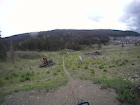
No description for Morel has been added yet! Login or register to submit one.Primary Trail Type: Cross-Country
Land Status: Crown Land
Activities Click to view
- Mountain Bike
1 trails
- Hike
1 trails
- Trail Running
1 trails
Region Details
- 1
Region Status
Caution as of Apr 13, 2026Stats
- Avg Trail Rating
- Trails (view details)
- 1
- Trails Mountain Bike
- 1
- Trails Hike
- 1
- Trails Trail Running
- 1
- Total Distance
- 3,162 ft
- Total Descent
- 199 ft
- Total Vertical
- 179 ft
- Highest Trailhead
- 3,438 ft
- Reports
- 13
- Photos
- 10
- Ridden Counter
- 54
Popular Morel Mountain Biking Trails
• 25 ★ 4.0 • 1 mile • 286 ft • 12 •
Less popular blue difficulty singletrack. This mountain bike primary trail can be used both directions with a 286 ft blue climb. On average it takes 17 minutes to complete this trail.
• 5 ★ 0.0 • 1 mile • 187 ft • 9 •
Less popular blue difficulty singletrack. This mountain bike primary trail can be used both directions with a 187 ft blue climb. On average it takes 17 minutes to complete this trail.
• 5 ★ 3.0 • 2,042 ft • 100 ft • 8 •
Less popular blue difficulty singletrack. This mountain bike primary trail can be used both directions and has a moderate overall physical rating with a 100 ft blue climb. Trail visibility is sometimes hard to follow. On average it takes 6 minutes to complete this trail.
• 5 ★ 0.0 • 3,162 ft • 28 ft • 4 •
Less popular blue difficulty singletrack. This mountain bike primary trail can be used both directions with a 28 ft blue climb. On average it takes 5 minutes to complete this trail.

Recent Trail Reports
| status | trail | date | condition | info | user |
|---|---|---|---|---|---|
| On the other side | Aug 18, 2021 @ 6:12pm Aug 18, 2021 | Very Dry | Bricklin69 | ||
| Inside Passage | Aug 18, 2021 @ 6:12pm Aug 18, 2021 | Very Dry | Bricklin69 | ||
| The Balsam Express | Aug 18, 2021 @ 6:12pm Aug 18, 2021 | Very Dry | Bricklin69 | ||
| Loop outside of another loop | Aug 18, 2021 @ 6:12pm Aug 18, 2021 | Very Dry | Bricklin69 | ||
| IN | Aug 18, 2021 @ 6:12pm Aug 18, 2021 | Very Dry | Bricklin69 |
Activity Feed
| username | action | type | title | date |
|---|---|---|---|---|
| trailforks | add | video | activity #87507598 | Jan 19, 2026 @ 7:00pm Jan 19, 2026 |
| TbayBolt | ridden | trail | activity #71492394 | May 11, 2025 @ 6:44pm May 11, 2025 |
| trailforks | add | video | activity #51610309 | Apr 23, 2024 @ 10:00pm Apr 23, 2024 |
| mmatthews | add | video | activity #51076078 | Apr 12, 2024 @ 8:00am Apr 12, 2024 |
| Bricklin69 | add | report | activity #22283657 and 4 more | Aug 19, 2021 @ 8:02am Aug 19, 2021 |
Nearby Areas
| name | distance | ||||
|---|---|---|---|---|---|
| Cartwright Mountain | 5 | 18 | 4 | 5.3 km | |
| Conkle Mountain | 3 | 7 | 5.6 km | ||
| Brent Mountain Protected Area | 5 | 3 | 10.4 km | ||
| Okanagan Mountain Park | 1 | 5 | 4 | 10.7 km | |
| Chute Lake | 1 | 11.1 km |
Activity Type Stats
| activitytype | trails | distance | descent | descent distance | total vertical | rating | global rank | state rank | photos | reports | routes | ridelogs |
|---|---|---|---|---|---|---|---|---|---|---|---|---|
| Mountain Bike | 1 | 3,163 ft | 200 ft | 2,156 ft | 180 ft | #11,920 | #407 | 10 | 13 | 64 | ||
| Hike | 1 | 3,163 ft | 200 ft | 2,156 ft | 180 ft | #21,732 | #697 | 13 | 105 | |||
| Trail Running | 1 | 3,163 ft | 200 ft | 2,156 ft | 180 ft | #20,922 | #663 | 13 | 1 |
- By Coneofsilence
 TRAILFORKS & contributors
 - Admins: PACA, SMBA, headspacej, PACA, 1partatatime, PACApenticton
- #28748 - 1,728 views
- morel activity log | embed map of Morel mountain bike trails |
Downloading of trail gps tracks in kml & gpx formats is enabled for Morel.
You must login to download files.