close
-
Layers w
- Weather Layers
- Pro
- Pro
- Pro
- Pro
- Pro
- Pro
- More Layers
- Pro
- Pro
- Pro
- Pro
-
Upgrade to

3D
Trail Conditions
- Unknown
- Snow Groomed
- Snow Packed
- Snow Covered
- Snow Cover Partial
- Freeze/thaw Cycle
- Icy
- Prevalent Mud
- Wet
- Variable
- Ideal
- Dry
- Very Dry
Trail Flow (Ridden Direction)
Trailforks scans users ridelogs to determine the most popular direction each trail is ridden. A good flowing trail network will have most trails flowing in a single direction according to their intension.
The colour categories are based on what percentage of riders are riding a trail in its intended direction.
The colour categories are based on what percentage of riders are riding a trail in its intended direction.
- > 96%
- > 90%
- > 80%
- > 70%
- > 50%
- < 50%
- bi-directional trail
- no data
Trail Last Ridden
Trailforks scans ridelogs to determine the last time a trail was ridden.
- < 2 days
- < 1 week
- < 2 weeks
- < 1 month
- < 6 months
- > 6 months
Trail Ridden Direction
The intended direction a trail should be ridden.
- Downhill Only
- Downhill Primary
- Both Directions
- Uphill Primary
- Uphill Only
- One Direction
Contribute Details
Colors indicate trail is missing specified detail.
- Description
- Photos
- Description & Photos
- Videos
Trail Popularity ?
Trailforks scans ridelogs to determine which trails are ridden the most in the last 9 months.
Trails are compared with nearby trails in the same city region with a possible 25 colour shades.
Think of this as a heatmap, more rides = more kinetic energy = warmer colors.
- most popular
- popular
- less popular
- not popular
ATV/ORV/OHV Filter
Max Vehicle Width
inches
US Cell Coverage
Legend

Radar Time
Activity Recordings
Trailforks uses anonymized public activity data.
?
Activity Recordings
Trailforks uses anonymized public activity data.
?
Personal Heatmap
▶
Activity Types
all
/
none
▶
Options
2
Date range
month
–
Winter Trails
Warning
A routing network for winter maps does not exist. Selecting trails using the winter trails layer has been disabled.
Missing Trails
Most Popular
Least Popular
Trails are colored based on popularity. The more popular a trail is, the more red. Less popular trails trend towards green.
Jump Magnitude Heatmap
Heatmap of where riders jump on trails. Zoom in to see individual jumps, click circles to view jump details.
BC Backroad Status
![map legend]()
Service Road Atlas is a free to use, community-driven service for viewing and creating reports on the numerous back-country service roads around B.C. and Alberta.

Slope Aspect
Direction the slope faces
Trails Deemphasized
Trails are shown in grey.
Only show trails with no bike usage.
Suggested Layers
Based on selected activity type
Save the current map location and zoom level as your default home location whenever this page is loaded.
Save
No description for Morgins has been added yet!
Login or register to submit one.
This region uses the Uk/Euro style trail grading system.
Activities Click to view
- Mountain Bike
11 trails
- E-Bike
5 trails
- Hike
6 trails
- Trail Running
6 trails
Region Details
- 4
- 3
- 2
- 2
Region Status
Open as of Sep 8, 2025Stats
- Avg Trail Rating
- Trails (view details)
- 11
- Trails Mountain Bike
- 11
- Trails E-Bike
- 5
- Trails Hike
- 6
- Trails Trail Running
- 6
- Total Distance
- 19 miles
- Total Descent
- 7,379 ft
- Total Vertical
- 2,139 ft
- Highest Trailhead
- 6,483 ft
- Reports
- 44
- Photos
- 134
- Ridden Counter
- 3,586
Articles
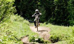
Video: Neko Mulally Shreds Some of the Best Turns in the World in Morgins
Aug 20, 2021 from pinkbike.com
Neko opens the throttle.
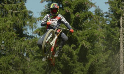
Video: Peaty, Minnaar, Vergier & Shaw Mob Morgins
Sep 18, 2020 from pinkbike.com
The train of pain blasting through Morgins' trails.

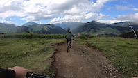
Video: Wide Open in Morgins with Neko Mulally
Aug 21, 2019 from pinkbike.com
Gorgeous corners and supersonic speed.
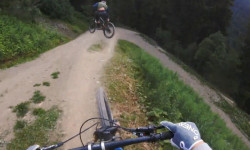
Video: Vinny T Shreds Morgins Bike Park
Jul 21, 2019 from pinkbike.com
Morgins may not be the first name you think of when it comes to European bike parks, but it's one of the best with some incredible trails
Sub Regions
-
Morgins BikePark
- 1
- 2
- 2
Popular Morgins Mountain Biking Trails
• 80 ★ 4.8 • 1 mile • 0 ft • 659 •
High speed trail with little drops all over the trail. Some bigger jump options on the sides of the trail with gaps.
• 100 ★ 5.0 • 1 mile • 2 ft • 645 •
Fast flow trail with smooth berms and fun little jumps. This trail is fast and wide open through large meadows. Little rock drops and even some rooty sections make it fun at high speed even for advanced riders.
• 60 ★ 4.7 • 2,024 ft • 0 ft • 466 •
Great trail that is a bit more narrow than the more popular machine groomed runs. Successive drops and a nice gap jump right at the bottom before merging with Trail
• 100 ★ 0.0 • 1 mile • 0 ft • 231 •
Popular blue difficulty alpine singletrack. This multi-use trail can be used downhill primary. Trail visibility is always easy to follow. On average it takes 5 minutes to complete this trail.
• 5 ★ 5.0 • 3,002 ft • 0 ft • 4 • • hike
Technical steep singletrack at the top and more flowing/faster and flatter bottom
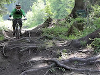
Photos of Morgins Mountain Bike
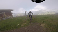
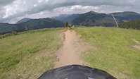
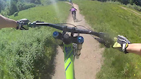
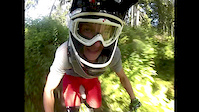
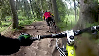
Videos of Morgins Mountain Bike
trail: La Çarigole
0:50 |
22 |
Oct 25, 2020
trail: La Çarigole
3:30 |
39 |
Mar 26, 2019
trail: La Çarigole
3:55 |
53 |
Mar 26, 2019
trail: La Çarigole
3:08 |
447 |
Jul 6, 2015
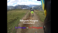
trail: La Tobogane
5:25 |
626 |
Sep 19, 2014
trail: La Tobogane
4:34 |
497 |
Dec 9, 2013
trail: La Çarigole
9:48 |
1550 |
Nov 9, 2013
trail: La Tobogane
3:44 |
390 |
Aug 16, 2013
Recent Trail Reports
| status | trail | date | condition | info | user |
|---|---|---|---|---|---|
| Vallon de They | Sep 8, 2025 @ 9:27am Sep 8, 2025 | Wet | Jv0fwKJE | ||
| La Tobogane | Sep 6, 2025 @ 12:56pm Sep 6, 2025 | Variable | bikefritzel ZO-Biketrails | ||
| La Madzé | Sep 6, 2025 @ 12:56pm Sep 6, 2025 | Variable | bikefritzel ZO-Biketrails | ||
| La Çarigole | Sep 6, 2025 @ 12:56pm Sep 6, 2025 | Variable | bikefritzel ZO-Biketrails | ||
| Foilleuse | Aug 11, 2024 @ 1:24pm Aug 11, 2024 | Dry | JamMad | ||
| La Noire (Upper) | Jul 28, 2024 @ 3:14am Jul 28, 2024 | Ideal | lachlan7 | ||
| La Crête Liaison | Jun 29, 2024 @ 11:57pm Jun 29, 2024 | Ideal | Sanski | ||
| Portes de Culet | Jun 29, 2024 @ 11:57pm Jun 29, 2024 | Wet | Sanski | ||
| La Noire | Jul 28, 2022 @ 6:16am Jul 28, 2022 | Ideal | Fullsend06 | ||
| Piste des Bochasses | Aug 24, 2020 @ 12:57am Aug 24, 2020 | Dry | Ivkov |
Activity Feed
| username | action | type | title | date |
|---|---|---|---|---|
| Reoh | wishlist | region | activity #96378050 | Jun 6, 2026 @ 9:10am Jun 6, 2026 |
| jamiewallace81 | add | video | activity #92240197 | Apr 9, 2026 @ 2:00am Apr 9, 2026 |
| Schnabel84 | wishlist | trail | activity #90504925 | Mar 13, 2026 @ 12:08pm Mar 13, 2026 |
| zugerrider | update | trail | activity #81404041 and 2 more | Sep 30, 2025 @ 1:57am Sep 30, 2025 |
| BFG129 | ridden | trail | activity #80223586 and 4 more | Sep 13, 2025 @ 12:50am Sep 13, 2025 |
Recent Comments
| username | type | title | comment | date |
|---|---|---|---|---|
| trail | Speedy track, fun to ride, it's easier than... | Sep 15, 2024 @ 11:16am Sep 15, 2024 | ||
| trail | Some root and rocks, if you don't do the jumps... | Sep 15, 2024 @ 11:15am Sep 15, 2024 |
Local Badges
-

Epic Mountain Bike Climb 2k188 awarded -

Climbing 10k Badge12 awarded -

Mountain Biking 100k Badge0 awarded -

Big Ride 30k140 awarded -

Epic Ride 50k35 awarded -

Epic Ride Descent 2k17 awarded
Bike & Skill Parks
| name | type | city | rating |
|---|---|---|---|
| Morgins BikePark | bike park | Morgins | |
| Pumptrack Morgins | skill park | Morgins | |
| Pumptrack Morgins | skill park | Morgins |
Local Mountain Biking Directory
-
Bike Pro Shop By SnowlineBike Shop
-
Rs equipementBike Shop
Activity Type Stats
| activitytype | trails | distance | descent | descent distance | total vertical | rating | global rank | state rank | photos | reports | routes | ridelogs |
|---|---|---|---|---|---|---|---|---|---|---|---|---|
| Mountain Bike | 11 | 19 miles | 7,379 ft | 10 miles | 2,139 ft | #2,597 | #33 | 134 | 44 | 1,040 | ||
| E-Bike | 5 | 15 miles | 2,238 ft | 5 miles | 2,060 ft | #2,995 | #113 | 41 | 45 | |||
| Hike | 6 | 15 miles | 2,844 ft | 6 miles | 2,139 ft | #4,729 | #105 | 41 | 53 | |||
| Trail Running | 6 | 15 miles | 2,844 ft | 6 miles | 2,139 ft | #4,171 | #83 | 41 | 30 |
Frequently Asked Questions About Morgins
▼
What are the best places to ride in Morgins?
Morgins has 1 areas to explore for mountain biking. The top rated areas are:
▼
What are the highest rated mountain biking trails in Morgins?
The highest rated mountain biking trails in Morgins are:
- La Çarigole (4.5/5)
- La Tobogane (4.5/5)
- La Madzé (4.3/5)
- Corbeau Footpath (4.1/5)
- Portes de Culet (0/5)
▼
What is the best time of the year to ride in Morgins?
Based on ride log data, the most popular months to ride in Morgins are:
- August (24 activities)
- July (19 activities)
- June (12 activities)
▼
Where can I park to ride in Morgins?
Check the Morgins trail map for trailhead and parking information. Community members regularly update access and parking details for trails in the area.
Activities
Trails
Points of Interest
- By StephaneMarceau
 TRAILFORKS & contributors
 - Admins: VS-Admin, VS-Admin
- #14812 - 6,094 views
- morgins activity log | embed map of Morgins mountain bike trails |
Downloading of trail gps tracks in kml & gpx formats is enabled for Morgins.
You must login to download files.