close
-
Layers w
- Weather Layers
- Pro
- Pro
- Pro
- Pro
- Pro
- Pro
- More Layers
- Pro
- Pro
- Pro
- Pro
-
Upgrade to

3D
Trail Conditions
- Unknown
- Snow Groomed
- Snow Packed
- Snow Covered
- Snow Cover Partial
- Freeze/thaw Cycle
- Icy
- Prevalent Mud
- Wet
- Variable
- Ideal
- Dry
- Very Dry
Trail Flow (Ridden Direction)
Trailforks scans users ridelogs to determine the most popular direction each trail is ridden. A good flowing trail network will have most trails flowing in a single direction according to their intension.
The colour categories are based on what percentage of riders are riding a trail in its intended direction.
The colour categories are based on what percentage of riders are riding a trail in its intended direction.
- > 96%
- > 90%
- > 80%
- > 70%
- > 50%
- < 50%
- bi-directional trail
- no data
Trail Last Ridden
Trailforks scans ridelogs to determine the last time a trail was ridden.
- < 2 days
- < 1 week
- < 2 weeks
- < 1 month
- < 6 months
- > 6 months
Trail Ridden Direction
The intended direction a trail should be ridden.
- Downhill Only
- Downhill Primary
- Both Directions
- Uphill Primary
- Uphill Only
- One Direction
Contribute Details
Colors indicate trail is missing specified detail.
- Description
- Photos
- Description & Photos
- Videos
Trail Popularity ?
Trailforks scans ridelogs to determine which trails are ridden the most in the last 9 months.
Trails are compared with nearby trails in the same city region with a possible 25 colour shades.
Think of this as a heatmap, more rides = more kinetic energy = warmer colors.
- most popular
- popular
- less popular
- not popular
ATV/ORV/OHV Filter
Max Vehicle Width
inches
US Cell Coverage
Legend

Radar Time
Activity Recordings
Trailforks uses anonymized public activity data.
?
Activity Recordings
Trailforks uses anonymized public activity data.
?
Personal Heatmap
▶
Activity Types
all
/
none
▶
Options
2
Date range
month
–
Winter Trails
Warning
A routing network for winter maps does not exist. Selecting trails using the winter trails layer has been disabled.
Missing Trails
Most Popular
Least Popular
Trails are colored based on popularity. The more popular a trail is, the more red. Less popular trails trend towards green.
Jump Magnitude Heatmap
Heatmap of where riders jump on trails. Zoom in to see individual jumps, click circles to view jump details.
BC Backroad Status
![map legend]()
Service Road Atlas is a free to use, community-driven service for viewing and creating reports on the numerous back-country service roads around B.C. and Alberta.

Slope Aspect
Direction the slope faces
Trails Deemphasized
Trails are shown in grey.
Only show trails with no bike usage.
Suggested Layers
Based on selected activity type
Save the current map location and zoom level as your default home location whenever this page is loaded.
Save
No description for Morocco has been added yet!
Login or register to submit one.
This region uses the Uk/Euro style trail grading system.
Region Details
- 35
- 2
- 12
- 15
- 5
- 2
Stats
- Avg Trail Rating
- Trails (view details)
- 71
- Trails Mountain Bike
- 73
- Trails E-Bike
- 68
- Trails Horse
- 1
- Trails Hike
- 73
- Trails Trail Running
- 73
- Total Distance
- 102 miles
- Total Descent Distance
- 47 miles
- Total Descent
- 20,829 ft
- Total Vertical
- 9,456 ft
- Highest Trailhead
- 9,911 ft
- Reports
- 63
- Photos
- 150
- Ridden Counter
- 416
Articles
Video: A mountain bike film trough Morocco in "Moroccolors"
Jan 24, 2025 from pinkbike.com
Riding Bikes through the vibrant chaos of Marrakech, the dazzling colours and vastness of the Atlas, and the rolling dunes of Essaouira.
7 Things to Know When You're Planning a Trip to Morocco
Apr 7, 2019 from pinkbike.com
Don't expect luxury, know how to repair your bike, and more tips to enjoy your time in Morocco.
Sub Regions
- Beni Melal-Jenifra (1)
- Casablanca-Settat (0)
- Dajla-Río de Oro (0)
- Draa-Tafilalet (0)
- El Aaiún-Saguía el-Hamra (0)
- Fez-Mequinez (0)
- Guelmim-Ued Nun (0)
- Marrakech-Safí (68)
- Oujda (0)
- Rabat-Salé-Kenitra (0)
- Souss-Massa. (0)
- Tánger-Tetuán-Alhucemas (0)
- Casablanca (4)
- Marrakech (16)
Popular Morocco Mountain Biking Trails
• 60 ★ 0.0 • 3 miles • 103 ft • 14 •
Awesome downhill, with different terrain, some rocky parts, flowy one and fast ! Nice view on the valley !
• 5 ★ 0.0 • 5 miles • 39 ft • 10 •
Awesome trail in the forest with rocks and turns !
• ★ 0.0 • 4 miles • 532 ft • 10 •
An unusual terrain composed of compacted pebbles, which is incredibly gippy and feels like riding on Velcro.
• 5 ★ 0.0 • 1,512 ft • 3 ft • 7 •
Steep singletrack with rocks and dust, lot of hiker and mule.
• 5 ★ 0.0 • 3 miles • 138 ft • 7 •
First part is a balcony singletrack with nice view, some short climbs, and then downhill with some full gaz parts, epic landscape and fun terrain !
• 100 ★ 4.0 • 3 miles • 91 ft • 7 •
First part with sharp rocks, and few switch-backs, 2nd part flowy singletrack into a pine trees forest, last part rock garden in a river bed and back to a jeep track that gets you back to the road
• 5 ★ 0.0 • 712 ft • 57 ft • 5 •
Nice singletrack to go trough the town, some stairs to climb.
Morocco Mountain Bike Routes
14 miles • 879 ft • 5 • Point to Point •
What a ride, lot of rocks, nice views, small village, small singletrack, a very nice ride !
16 miles • 97 ft • 0 •
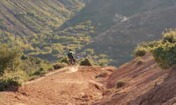
Photos of Morocco Mountain Bike
Recent Comments
| username | type | title | comment | date |
|---|---|---|---|---|
| trail | In the Upper third sometimes hard to follow... | Aug 27, 2025 @ 8:12am Aug 27, 2025 | ||
| trail | Sendero poco frecuentado de momento, la... | May 3, 2023 @ 10:05am May 3, 2023 | ||
| trail | One of my favourite natural downhill trails... | Aug 30, 2021 @ 8:11am Aug 30, 2021 |
Activity Type Stats
| activitytype | trails | distance | descent | descent distance | total vertical | rating | global rank | state rank | photos | reports | routes | ridelogs |
|---|---|---|---|---|---|---|---|---|---|---|---|---|
| Mountain Bike | 73 | 102 miles | 20,830 ft | 47 miles | 9,455 ft | #88 | 150 | 63 | 2 | 8,671 | ||
| E-Bike | 68 | 87 miles | 18,901 ft | 38 miles | 3,583 ft | #71 | 62 | 2 | 453 | |||
| Horse | 1 | #89 | 3 | |||||||||
| Hike | 73 | 102 miles | 20,830 ft | 47 miles | 9,455 ft | #81 | 60 | 3,151 | ||||
| Trail Running | 73 | 102 miles | 20,830 ft | 47 miles | 9,455 ft | #78 | 60 | 178 |
Activities
Trails
- By canadaka
 Trailforks & contributors
 - Admins: freerider48
- #3245 - 9,384 views
- morocco activity log | embed map of Morocco mountain bike trails | morocco mountain biking points of interest polygons
Downloading of trail gps tracks in kml & gpx formats is enabled for Morocco.
You must login to download files.