close
-
Layers w
- Weather Layers
- Pro
- Pro
- Pro
- Pro
- Pro
- Pro
- More Layers
- Pro
- Pro
- Pro
- Pro
-
Upgrade to

3D
Trail Conditions
- Unknown
- Snow Groomed
- Snow Packed
- Snow Covered
- Snow Cover Partial
- Freeze/thaw Cycle
- Icy
- Prevalent Mud
- Wet
- Variable
- Ideal
- Dry
- Very Dry
Trail Flow (Ridden Direction)
Trailforks scans users ridelogs to determine the most popular direction each trail is ridden. A good flowing trail network will have most trails flowing in a single direction according to their intension.
The colour categories are based on what percentage of riders are riding a trail in its intended direction.
The colour categories are based on what percentage of riders are riding a trail in its intended direction.
- > 96%
- > 90%
- > 80%
- > 70%
- > 50%
- < 50%
- bi-directional trail
- no data
Trail Last Ridden
Trailforks scans ridelogs to determine the last time a trail was ridden.
- < 2 days
- < 1 week
- < 2 weeks
- < 1 month
- < 6 months
- > 6 months
Trail Ridden Direction
The intended direction a trail should be ridden.
- Downhill Only
- Downhill Primary
- Both Directions
- Uphill Primary
- Uphill Only
- One Direction
Contribute Details
Colors indicate trail is missing specified detail.
- Description
- Photos
- Description & Photos
- Videos
Trail Popularity ?
Trailforks scans ridelogs to determine which trails are ridden the most in the last 9 months.
Trails are compared with nearby trails in the same city region with a possible 25 colour shades.
Think of this as a heatmap, more rides = more kinetic energy = warmer colors.
- most popular
- popular
- less popular
- not popular
ATV/ORV/OHV Filter
Max Vehicle Width
inches
US Cell Coverage
Legend

Radar Time
Activity Recordings
Trailforks uses anonymized public activity data.
?
Activity Recordings
Trailforks uses anonymized public activity data.
?
Personal Heatmap
▶
Activity Types
all
/
none
▶
Options
2
Date range
month
–
Winter Trails
Warning
A routing network for winter maps does not exist. Selecting trails using the winter trails layer has been disabled.
Missing Trails
Most Popular
Least Popular
Trails are colored based on popularity. The more popular a trail is, the more red. Less popular trails trend towards green.
Jump Magnitude Heatmap
Heatmap of where riders jump on trails. Zoom in to see individual jumps, click circles to view jump details.
BC Backroad Status
![map legend]()
Service Road Atlas is a free to use, community-driven service for viewing and creating reports on the numerous back-country service roads around B.C. and Alberta.

Slope Aspect
Direction the slope faces
Trails Deemphasized
Trails are shown in grey.
Only show trails with no bike usage.
Suggested Layers
Based on selected activity type
Save the current map location and zoom level as your default home location whenever this page is loaded.
SaveNOTE: Moss Lake Natural Area is a King County Department of Natural Resources and Parks (DNRP) Ecological Land. The site is located 5 miles southeast of Duvall, 3.5 miles northeast of Carnation, and 1 mile east of Lake Joy in the Cascade foothills. The site is comprised of 372 acres of high-quality wetland and forested upland habitats. An extensive Class 1 wetland complex encompasses a large sphagnum bog, beaver dams, open water and forested wetland.
In November of 2024, the Tulalip Tribe purchased the land immediately north and east of the Natural Area boundaries. The tribe shares:
"The Tulalip Tribes respectfully ask the public to honor the boundaries of our “Skyline” forestlands, which are currently closed to public access. In November 2024, the Tribes acquired approximately 18,000 acres of the Snoqualmie Tree Farm — a landscape of deep ancestral significance. This land will be cared for as a working forest, supporting tribal programs and restoring the ecological richness in a way that would be recognizable to our ancestors.
As descendants of the Snohomish, Snoqualmie, Skykomish, and allied peoples who signed the 1855 Treaty of Point Elliott, our connection to these lands runs deep. We kindly ask that visitors refrain from entering Tulalip lands via adjacent areas such as DNR’s Marckworth Forest, the City of Seattle’s Tolt Pipeline Trail, King County’s Moss Lake Preserve, or neighboring timberlands. Campbell Global recreation permit holders are asked to remain south of the North Fork Tolt River on designated Campbell roads and lands.
The Tulalip Tribes are committed to working collaboratively with neighboring communities, agencies, and nonprofit partners to steward this forest with care and intention. If you have questions or would like to learn more, please reach out to [email protected]."
Evergreen Mountain Bike Alliance
Primary Trail Type: Cross-Country
eBikes Allowed:
Yes
 google parking directions
 Activities Click to view
- Mountain Bike
42 trails
- E-Bike
0 trails
- Horse
4 trails
- Hike
39 trails
- Trail Running
39 trails
Region Details
- 10
- 15
- 15
- 2
Region Status
Open as of Nov 25, 2025Local Trail Association
Stats
- Avg Trail Rating
- Trails (view details)
- 42
- Trails Mountain Bike
- 42
- Trails Horse
- 4
- Trails Hike
- 39
- Trails Trail Running
- 39
- Total Distance
- 17 miles
- Total Descent
- 2,499 ft
- Total Vertical
- 408 ft
- Highest Trailhead
- 784 ft
- Reports
- 429
- Photos
- 96
- Ridden Counter
- 3,232
Popular Moss Lake Mountain Biking Trails
• 80 ★ 0.0 • 4,839 ft • 158 ft • 258 •
Popular green difficulty singletrack. This mountain bike primary trail can be used both directions. On average it takes 6 minutes to complete this trail.
Knowhere Permanently Closed
• 60 ★ 0.0 • 2,362 ft • 21 ft • 115 •
If you're in the know, then you know that this trail goes nowhere.
• 65 ★ 0.0 • 3,041 ft • 37 ft • 105 •
New trail recently built by King County Parks.
FrAgile (R) Permanently Closed
• 5 ★ 5.0 • 1,056 ft • 0 ft • 91 •
A fun little downhill only trail with a few small drops, jumps and log-overs. Everything is rollable. A way in, this trail splits. Both (L) and (R) are fun.
• 65 ★ 0.0 • 1,040 ft • 22 ft • 72 •
Moderately popular green difficulty singletrack. This multi-use trail can be used both directions and has a easy overall physical rating with a 22 ft green climb. On average it takes 2 minutes to complete this trail.
Crazy 8 (No More) Permanently Closed
• 5 ★ 0.0 • 584 ft • 3 ft • 54 •
This trail was decimated when the area was clear cut. No trace left. Just here in case someone wants to rebuild it.
• 55 ★ 3.0 • 2 miles • 205 ft • 37 •
Moderately popular green difficulty singletrack. This multi-use trail can be used both directions and has a moderate overall physical rating with a 205 ft green climb. On average it takes 5 minutes to complete this trail.
FDR Permanently Closed
• 5 ★ 0.0 • 459 ft • 8 ft • 37 •
Less popular blue difficulty closed singletrack. This mountain bike primary trail can be used both directions and has a easy overall physical rating with a 8 ft green climb. On average it takes minutes to complete this trail.
Moss Lake Mountain Bike Routes
• 10 miles • 586 ft • 0 •
• 5 miles • 405 ft • 7 •
• 6 miles • 504 ft • 13 •
• 6 miles • 424 ft • 6 •
• 7 miles • 603 ft • 12 •
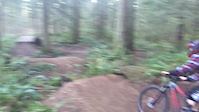
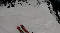
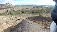
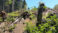
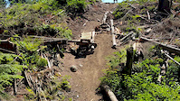
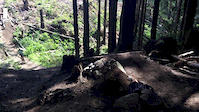
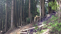
Photos of Moss Lake Mountain Bike
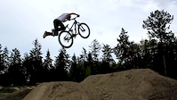
Videos of Moss Lake Mountain Bike
trail: RIM
0:22 |
540 |
Jan 28, 2019
trail: Landing
0:22 |
63 |
Apr 3, 2016
trail: Yellow
0:25 |
239 |
Dec 13, 2015
trail: Landing
0:52 |
5217 |
Aug 14, 2015
trail: Ridge
0:08 |
301 |
Jul 5, 2015
trail: Ridge
0:07 |
362 |
Jul 5, 2015
trail: Ridge
0:12 |
355 |
Jun 4, 2015
trail: Ridge
0:04 |
431 |
Jun 4, 2015
Recent Trail Reports
| status | trail | date | condition | info | user |
|---|---|---|---|---|---|
| FrAgile (R) | Nov 25, 2025 @ 6:58pm (America/Los_Angeles) Nov 25, 2025 | Unknown | chunky-tech-doctor | ||
| Knowhere | Nov 24, 2025 @ 9:21pm (America/Los_Angeles) Nov 24, 2025 | Unknown | chunky-tech-doctor | ||
| Lake Loop | Oct 28, 2023 @ 6:13am Oct 28, 2023 | Variable | naimo | ||
| Swan Loop | Oct 28, 2023 @ 6:13am Oct 28, 2023 | Variable | naimo | ||
| Lakeside Trail (Name TBD) | Jul 11, 2023 @ 4:58am Jul 11, 2023 | Ideal | Rcd1649 | ||
| The Loop | May 26, 2023 @ 8:19am May 26, 2023 | Ideal | Mystumpy | ||
| Swan Mill Pond | May 26, 2023 @ 8:19am May 26, 2023 | Ideal | Mystumpy | ||
| Moss lake- TBD | May 14, 2021 @ 10:04am May 14, 2021 | Ideal | Mystumpy | ||
| Road 25780 | Oct 2, 2020 @ 9:28am Oct 2, 2020 | Variable | boxxerace TRAILFORKS | ||
| Fox Glove Trail | Oct 2, 2020 @ 9:28am Oct 2, 2020 | Variable | boxxerace TRAILFORKS |
Activity Feed
| username | action | type | title | date |
|---|---|---|---|---|
| trailforks | add | video | activity #90736396 | Mar 17, 2026 @ 6:00am Mar 17, 2026 |
| Lehning | wishlist | region | activity #87109398 | Jan 12, 2026 @ 8:41pm Jan 12, 2026 |
| trailforks | add | video | activity #86813017 | Jan 7, 2026 @ 1:05pm Jan 7, 2026 |
| chunky-tech-doctor | add | report | activity #84730905 | Nov 25, 2025 @ 6:58pm Nov 25, 2025 |
| chunky-tech-doctor | add | report | activity #84686551 | Nov 24, 2025 @ 9:21pm Nov 24, 2025 |
Recent Comments
| username | type | title | comment | date |
|---|---|---|---|---|
| trail | This trails called rim and ironically I... | Jan 23, 2022 @ 5:39pm Jan 23, 2022 | ||
| trail | Definitely like L better worth doing R once | Jan 23, 2022 @ 5:38pm Jan 23, 2022 | ||
| trail | Fun, sessionable trail | Sep 26, 2021 @ 3:11pm Sep 26, 2021 | ||
| trail | Many roots, rocks, mud and mosquitos. May 30,... | May 31, 2021 @ 10:36am May 31, 2021 | ||
| trail | This is primarily used by horses, which is... | Dec 16, 2020 @ 12:56am Dec 16, 2020 |
Nearby Areas
| name | distance | ||||
|---|---|---|---|---|---|
| Marckworth State Forest | 2 | 2 | 4.1 km | ||
| Cherry Valley | 12 | 13 | 1 | 4.1 km | |
| Snoqualmine State Forest | 4 | 2 | 6.2 km | ||
| Tolt MacDonald Park | 17 | 55 | 5 | 6.2 km | |
| Tokul West | 13 | 13 | 11 | 1 | 8.2 km |
Local Badges
-

Completionist1 awarded
Local Products
Activity Type Stats
| activitytype | trails | distance | descent | descent distance | total vertical | rating | global rank | state rank | photos | reports | routes | ridelogs |
|---|---|---|---|---|---|---|---|---|---|---|---|---|
| Mountain Bike | 42 | 17 miles | 2,500 ft | 8 miles | 410 ft | #4,640 | #1,650 | 96 | 429 | 1 | 1,044 | |
| Horse | 4 | 3 miles | 535 ft | 2 miles | 285 ft | #3,320 | #1,968 | 51 | 3 | |||
| Hike | 39 | 17 miles | 2,221 ft | 7 miles | 410 ft | #8,515 | #3,202 | 412 | 111 | |||
| Trail Running | 39 | 17 miles | 2,221 ft | 7 miles | 410 ft | #7,824 | #2,659 | 412 | 19 |
Frequently Asked Questions About Moss Lake
▼
What are the highest rated mountain biking trails in Moss Lake?
The highest rated mountain biking trails in Moss Lake are:
- The Loop (3.8/5)
- Lake Loop (0/5)
- Lakeside Trail (Name TBD) (0/5)
- Moss lake- TBD (0/5)
▼
What is the best time of the year to ride in Moss Lake?
Based on ride log data, the most popular months to ride in Moss Lake are:
- August (23 activities)
- April (19 activities)
- July (18 activities)
▼
Where can I park to ride in Moss Lake?
There are 1 parking locations listed in Moss Lake. The most popular parking spots are:
▼
What is the longest trail in Moss Lake?
The longest trail in Moss Lake is The Loop at 1.5 miles. View all trails sorted by distance.
- By ACree
 & contributors
 - Admins: EMBA-C2S
- #5977 - 9,718 views
- moss lake activity log | embed map of Moss Lake mountain bike trails | moss lake mountain biking points of interest
Downloading of trail gps tracks in kml & gpx formats is enabled for Moss Lake.
You must login to download files.