close
-
Layers w
- Weather Layers
- Pro
- Pro
- Pro
- Pro
- Pro
- Pro
- More Layers
- Pro
- Pro
- Pro
- Pro
-
Upgrade to

3D
Trail Conditions
- Unknown
- Snow Groomed
- Snow Packed
- Snow Covered
- Snow Cover Partial
- Freeze/thaw Cycle
- Icy
- Prevalent Mud
- Wet
- Variable
- Ideal
- Dry
- Very Dry
Trail Flow (Ridden Direction)
Trailforks scans users ridelogs to determine the most popular direction each trail is ridden. A good flowing trail network will have most trails flowing in a single direction according to their intension.
The colour categories are based on what percentage of riders are riding a trail in its intended direction.
The colour categories are based on what percentage of riders are riding a trail in its intended direction.
- > 96%
- > 90%
- > 80%
- > 70%
- > 50%
- < 50%
- bi-directional trail
- no data
Trail Last Ridden
Trailforks scans ridelogs to determine the last time a trail was ridden.
- < 2 days
- < 1 week
- < 2 weeks
- < 1 month
- < 6 months
- > 6 months
Trail Ridden Direction
The intended direction a trail should be ridden.
- Downhill Only
- Downhill Primary
- Both Directions
- Uphill Primary
- Uphill Only
- One Direction
Contribute Details
Colors indicate trail is missing specified detail.
- Description
- Photos
- Description & Photos
- Videos
Trail Popularity ?
Trailforks scans ridelogs to determine which trails are ridden the most in the last 9 months.
Trails are compared with nearby trails in the same city region with a possible 25 colour shades.
Think of this as a heatmap, more rides = more kinetic energy = warmer colors.
- most popular
- popular
- less popular
- not popular
ATV/ORV/OHV Filter
Max Vehicle Width
inches
US Cell Coverage
Legend

Radar Time
Activity Recordings
Trailforks uses anonymized public activity data.
?
Activity Recordings
Trailforks uses anonymized public activity data.
?
Personal Heatmap
▶
Activity Types
all
/
none
▶
Options
2
Date range
month
–
Winter Trails
Warning
A routing network for winter maps does not exist. Selecting trails using the winter trails layer has been disabled.
Missing Trails
Most Popular
Least Popular
Trails are colored based on popularity. The more popular a trail is, the more red. Less popular trails trend towards green.
Jump Magnitude Heatmap
Heatmap of where riders jump on trails. Zoom in to see individual jumps, click circles to view jump details.
BC Backroad Status
![map legend]()
Service Road Atlas is a free to use, community-driven service for viewing and creating reports on the numerous back-country service roads around B.C. and Alberta.

Slope Aspect
Direction the slope faces
Trails Deemphasized
Trails are shown in grey.
Only show trails with no bike usage.
Suggested Layers
Based on selected activity type
Save the current map location and zoom level as your default home location whenever this page is loaded.
SaveThe Mount Borah downhill descends from 900 metres down to 450 metres over 3.5km with a track filled with natural rock gardens, drop-offs, gap jumps, doubles, off camber and the section known as "Wallaby’s Chute”.
The track is fast, flowy and full of natural obstacles . The track starts off on a gentle slope but then quickly becomes more gravity fed, high speed, with rock shelves, step downs, some sandy switchbacks, a tricky rock garden chute and some big jumps towards the bottom. There are A & B lines available right down the course, except down “Wallaby’s Chute” which is a gnarly rock drop that will thrill the pant’s off any rider.
The track is fast, flowy and full of natural obstacles . The track starts off on a gentle slope but then quickly becomes more gravity fed, high speed, with rock shelves, step downs, some sandy switchbacks, a tricky rock garden chute and some big jumps towards the bottom. There are A & B lines available right down the course, except down “Wallaby’s Chute” which is a gnarly rock drop that will thrill the pant’s off any rider.
Primary Trail Type: All-Mountain & Downhill
Shuttleable: YES
Land Status: Private Property
Access Info:
From Manilla (approx 10mins to Mt Borah), drive through town and then head north over the Namoi River Bridge. Turn left 200m after bridge into Boggabri Rd (you will see a paraglider graphic left pointer sign) Don't drive straight ahead to Barraba and Upper Manilla as directed by most Car GPS Navi units.
Continue on for ~1km and just after Manilla River concrete bridge turn right into Wimbourne Rd (you will see a paraglider graphic right pointer sign). After 300m Wimbourne Rd has a T intersection where you continue to the right.
Continue on for ~11kms (its gravel after 6kms). There are two big creek dips as you travel. Just after the 2nd big dip (gully crossing) at 11kms turn right into Manilla Paragliding sign posted driveway.
NOTE: Mt Borah access road is 50m further along Wimbourne Rd on left.
Disclaimer:
Mount Borah Trails are on private property - The main gate is locked. The key is controlled by the club and can be collect from the bike shop The Broken Spoke - (02) 6766 9557. You will be charge a key deposit and be asked to donate some trail fees.
Please abide to NSW Government Covid regulations and restrictions.
Please abide to NSW Government Covid regulations and restrictions.
Activities Click to view
- Mountain Bike
32 trails
- E-Bike
22 trails
- Hike
29 trails
- Trail Running
29 trails
Region Details
- 7
- 7
- 1
Region Status
Open as of Apr 18, 2026Stats
- Avg Trail Rating
- Global Ranking
- #5,221
- Trails (view details)
- 15
- Trails Mountain Bike
- 32
- Trails E-Bike
- 22
- Trails Hike
- 29
- Trails Trail Running
- 29
- Total Distance
- 9 miles
- Total Descent Distance
- 8 miles
- Total Descent
- 4,603 ft
- Total Vertical
- 1,481 ft
- Highest Trailhead
- 2,944 ft
- Reports
- 69
- Photos
- 44
- Ridden Counter
- 417
Popular Mount Borah Mountain Biking Trails
• 100 ★ 0.0 • 3,356 ft • 0 ft • 38 •
Easy flow trail that ends at the top table top plateau. This is also the end of Stage 1 of the Enduro Trails, when the club races
• 45 ★ 5.0 • 1 mile • 7 ft • 37 •
This track has just been constructed. So be aware that it is still very loose for the first 800m. The first 200m of trail is the most technical and steep. Novice riders should consider walk this part first prior to riding. After the...
• 95 ★ 0.0 • 554 ft • 0 ft • 37 •
Mid point entry to the DH trail "Snake bite". This is also the start of Stage 1 of the Enduro Trails, when the club races.
• 60 ★ 4.0 • 3,058 ft • 0 ft • 36 •
is one of the easier trails on Mount Borah. It is predominately a downhill gradient single track that was created by following the original kangaroo/wallaby tracks. On several sections there are areas were line selection is abundant, so...
• 65 ★ 0.0 • 1,499 ft • 0 ft • 34 •
As the name suggests this is just a lot of twists and turns. All single track and very raw. The trail starts at a shuttle drop off and then leads you to the start of the trail. Enduro rides will love this section as it has flow and is...
• 90 ★ 0.0 • 253 ft • 0 ft • 31 •
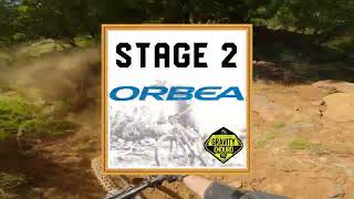
This short cut drops you onto the DH trail. This is also the start of Stage 2 of the Enduro Trails, when the club races.
• 5 ★ 5.0 • 2 miles • 8 ft • 31 •
is a technical downhill track approx. 3.5 km in length. There is a shuttle road to take you from the finish back to the trailhead. The track is on private property so you must go to the Paragliding club house and sign a waiver before...
• 85 ★ 0.0 • 968 ft • 0 ft • 26 •
starts at the bottom of Wallaby shoot on . It is best accessed from the new up climb.
Photos of Mount Borah Mountain Bike
Videos of Mount Borah Mountain Bike
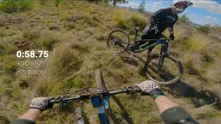
trail: Lightning
5:14 |
72 |
Jun 27, 2021
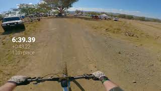
trail: Snake Bite
4:05 |
213 |
Jun 15, 2023 , Manilla
trail: Snake Bite
4:47 |
198 |
Jun 15, 2023 , Manilla

trail: Twist and Turns
4:45 |
132 |
Jun 15, 2023 , Manilla
trail: Chicken Run
0:18 |
115 |
Jun 15, 2023 , Manilla
trail: Chicken Run
0:12 |
112 |
Jun 15, 2023 , Manilla
trail: Lightning
7:18 |
120 |
Jun 15, 2023 , Manilla
trail: Lightning
7:41 |
138 |
Jun 15, 2023 , Manilla
Recent Trail Reports
| status | trail | date | condition | info | user |
|---|---|---|---|---|---|
| F'n Cows | Apr 19, 2026 @ 10:03am (Australia/Sydney) Apr 18, 2026 | Very Dry | Eggs78 | ||
| Twist and Turns | Apr 19, 2026 @ 10:03am (Australia/Sydney) Apr 18, 2026 | Very Dry | Eggs78 | ||
| The Short Cut | Mar 15, 2026 @ 4:28pm (Australia/Sydney) Mar 14, 2026 | Very Dry | Eggs78 | ||
| Chicken Run | Mar 15, 2026 @ 4:28pm (Australia/Sydney) Mar 14, 2026 | Very Dry | Eggs78 | ||
| Sideswipe | Mar 15, 2026 @ 4:28pm (Australia/Sydney) Mar 14, 2026 | Very Dry | Eggs78 | ||
| Split Rock | Mar 15, 2026 @ 4:28pm (Australia/Sydney) Mar 14, 2026 | Very Dry | Eggs78 | ||
| Exit Stage Left | Jul 12, 2025 @ 9:27am Jul 12, 2025 | Ideal | Eggs78 | ||
| Snake Bite | Jan 19, 2025 @ 9:36am Jan 19, 2025 | Ideal | Eggs78 | ||
| Dive Bomber | Jan 19, 2025 @ 9:36am Jan 19, 2025 | Ideal | Eggs78 | ||
| Flyover Trail | Jan 19, 2025 @ 9:36am Jan 19, 2025 | Ideal | Eggs78 |
Activity Feed
| username | action | type | title | date |
|---|---|---|---|---|
| JoshEasty | wishlist | region | activity #94250253 | May 7, 2026 @ 4:47pm May 7, 2026 |
| Eggs78 | add | report | activity #92929989 and 1 more | Apr 19, 2026 @ 3:10am Apr 19, 2026 |
| Eggs78 | add | report | activity #90672525 and 4 more | Mar 15, 2026 @ 6:12pm Mar 15, 2026 |
| avd316 | add | trail | activity #86457019 | Jan 1, 2026 @ 11:52am Jan 1, 2026 |
| avd316 | difficultyvote | trail | activity #85761349 | Dec 19, 2025 @ 6:31pm Dec 19, 2025 |
Recent Comments
| username | type | title | comment | date |
|---|---|---|---|---|
| trail | Thanks for the Comments Peedro.... Yep these... | Jun 27, 2021 @ 1:29am Jun 27, 2021 | ||
| trail | Recent developments and trail work has seen... | Aug 2, 2020 @ 4:27pm Aug 2, 2020 | ||
| trail | Proper enduro trail. Super rocky but heaps of... | Nov 8, 2017 @ 12:43am Nov 8, 2017 | ||
| trail | Such a sick trail, well built, plenty of tech... | Nov 8, 2017 @ 12:41am Nov 8, 2017 | ||
| report | Track clear and fast. Held up well to the last... | Nov 7, 2017 @ 6:22pm Nov 7, 2017 |
Nearby Areas
| name | distance | ||||
|---|---|---|---|---|---|
| Lake Keepit | 16.8 km | ||||
| Porcupine Reserve | 1 | 31.2 km | |||
| Tamworth Mountain Bike Park | 2 | 6 | 4 | 32.2 km | |
| Black Jack State Forest | 2 | 24 | 5 | 32.2 km | |
| Mount Kaputar National Park | 1 | 39.7 km |
Activity Type Stats
| activitytype | trails | distance | descent | descent distance | total vertical | rating | global rank | state rank | photos | reports | routes | ridelogs |
|---|---|---|---|---|---|---|---|---|---|---|---|---|
| Mountain Bike | 32 | 9 miles | 4,603 ft | 8 miles | 1,483 ft | #5,221 | 44 | 69 | 367 | |||
| E-Bike | 22 | 8 miles | 4,518 ft | 8 miles | 1,483 ft | #5,372 | #280 | 56 | 48 | |||
| Hike | 29 | 9 miles | 4,521 ft | 8 miles | 1,483 ft | #8,922 | #308 | 63 | 41 | |||
| Trail Running | 29 | 9 miles | 4,521 ft | 8 miles | 1,483 ft | #8,119 | #286 | 63 | 3 |
Frequently Asked Questions About Mount Borah
▼
What are the highest rated mountain biking trails in Mount Borah?
The highest rated mountain biking trails in Mount Borah are:
- Lightning (4.2/5)
- Snake Bite (4.2/5)
- Split Rock (4/5)
- Sideswipe (0/5)
- Dive Bomber (0/5)
▼
What is the best time of the year to ride in Mount Borah?
Based on ride log data, the most popular months to ride in Mount Borah are:
- June (4 activities)
- April (2 activities)
- May (1 activities)
▼
Where can I park to ride in Mount Borah?
Check the Mount Borah trail map for trailhead and parking information. Community members regularly update access and parking details for trails in the area.
▼
What is the longest trail in Mount Borah?
The longest trail in Mount Borah is Snake Bite at 3.5 km. View all trails sorted by distance.
Activities
- By Addzz
 TRAILFORKS NEMTB & contributors
 - Admins: apply
- #13187 - 10,724 views
- mount borah activity log | embed map of Mount Borah mountain bike trails | mount borah mountain biking points of interest
Downloading of trail gps tracks in kml & gpx formats is enabled for Mount Borah.
You must login to download files.