close
-
Layers w
- Weather Layers
- Pro
- Pro
- Pro
- Pro
- Pro
- Pro
- More Layers
- Pro
- Pro
- Pro
- Pro
-
Upgrade to

3D
Trail Conditions
- Unknown
- Snow Groomed
- Snow Packed
- Snow Covered
- Snow Cover Partial
- Freeze/thaw Cycle
- Icy
- Prevalent Mud
- Wet
- Variable
- Ideal
- Dry
- Very Dry
Trail Flow (Ridden Direction)
Trailforks scans users ridelogs to determine the most popular direction each trail is ridden. A good flowing trail network will have most trails flowing in a single direction according to their intension.
The colour categories are based on what percentage of riders are riding a trail in its intended direction.
The colour categories are based on what percentage of riders are riding a trail in its intended direction.
- > 96%
- > 90%
- > 80%
- > 70%
- > 50%
- < 50%
- bi-directional trail
- no data
Trail Last Ridden
Trailforks scans ridelogs to determine the last time a trail was ridden.
- < 2 days
- < 1 week
- < 2 weeks
- < 1 month
- < 6 months
- > 6 months
Trail Ridden Direction
The intended direction a trail should be ridden.
- Downhill Only
- Downhill Primary
- Both Directions
- Uphill Primary
- Uphill Only
- One Direction
Contribute Details
Colors indicate trail is missing specified detail.
- Description
- Photos
- Description & Photos
- Videos
Trail Popularity ?
Trailforks scans ridelogs to determine which trails are ridden the most in the last 9 months.
Trails are compared with nearby trails in the same city region with a possible 25 colour shades.
Think of this as a heatmap, more rides = more kinetic energy = warmer colors.
- most popular
- popular
- less popular
- not popular
ATV/ORV/OHV Filter
Max Vehicle Width
inches
US Cell Coverage
Legend

Radar Time
Activity Recordings
Trailforks uses anonymized public activity data.
?
Activity Recordings
Trailforks uses anonymized public activity data.
?
Personal Heatmap
▶
Activity Types
all
/
none
▶
Options
2
Date range
month
–
Winter Trails
Warning
A routing network for winter maps does not exist. Selecting trails using the winter trails layer has been disabled.
Missing Trails
Most Popular
Least Popular
Trails are colored based on popularity. The more popular a trail is, the more red. Less popular trails trend towards green.
Jump Magnitude Heatmap
Heatmap of where riders jump on trails. Zoom in to see individual jumps, click circles to view jump details.
BC Backroad Status
![map legend]()
Service Road Atlas is a free to use, community-driven service for viewing and creating reports on the numerous back-country service roads around B.C. and Alberta.

Slope Aspect
Direction the slope faces
Trails Deemphasized
Trails are shown in grey.
Only show trails with no bike usage.
Suggested Layers
Based on selected activity type
Save the current map location and zoom level as your default home location whenever this page is loaded.
Save
No description for Mount Dora has been added yet!
Login or register to submit one.
Links
Activities Click to view
- Mountain Bike
36 trails
- E-Bike
36 trails
- Gravel Bike
1 trails
- Adaptive Bike
0 trails
- Winter Fat Bike
0 trails
- Hike
18 trails
- Trail Running
18 trails
Region Details
- 9
- 8
- 11
- 5
- 3
Region Status
Open as of May 21, 2026Stats
- Avg Trail Rating
- Trails (view details)
- 36
- Trails Mountain Bike
- 38
- Trails E-Bike
- 36
- Trails Gravel Bike
- 1
- Trails Hike
- 18
- Trails Trail Running
- 18
- Total Distance
- 8 miles
- Total Descent
- 627 ft
- Total Vertical
- 97 ft
- Highest Trailhead
- 177 ft
- Reports
- 657
- Photos
- 54
- Ridden Counter
- 18,194
Sub Regions
-
Hidden Water Preserve
- 1
-
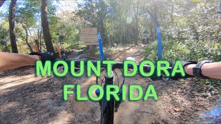
Mount Dora MTB Trails
- 3
- 11
- 4
- 3
Popular Mount Dora Mountain Biking Trails
• 100 ★ 4.8 • 1,726 ft • 3 ft • 1,191 •
This fast flowy trail enters next to and after bombing the initial descent, you get ripped around 4 big wooden berms one after another. After navigating a few rooty switchbacks, you'll be greeted by a drop with a go-around option...
• 65 ★ 4.9 • 1 mile • 93 ft • 1,163 •
Highly rated moderately popular green difficulty singletrack. This mountain bike primary trail can be used one direction and has a moderate overall physical rating with a 93 ft blue climb. It features berm and bridge. Trail visibility is always easy to follow. On average it takes 19 minutes to complete this trail.
• 70 ★ 3.6 • 1,260 ft • 9 ft • 1,117 •
This blue trail will challenge your ability to squeeze in between trees, and then you will ride down a long skinny, do a 180 turn and come back on another long skinny. After completing both skinnies you will be rewarded with a fun...
• 95 ★ 4.7 • 1,909 ft • 24 ft • 1,104 •
Highly rated popular blue difficulty singletrack. This mountain bike primary trail can be used both directions. On average it takes 2 minutes to complete this trail.
• 80 ★ 4.9 • 997 ft • 0 ft • 1,092 •
Short connector trail takes you from into skipping the downhill trails, or from to and the Flow Trail.
• 70 ★ 3.8 • 656 ft • 7 ft • 1,017 •
Popular blue difficulty singletrack. This mountain bike primary trail can be used one direction. On average it takes minutes to complete this trail.
• 85 ★ 4.4 • 449 ft • 6 ft • 977 •
Highly rated popular blue difficulty singletrack. This mountain bike primary trail can be used both directions. On average it takes minutes to complete this trail.
• 75 ★ 4.0 • 688 ft • 11 ft • 943 •
Popular black diamond difficulty singletrack. This mountain bike primary trail can be used both directions. On average it takes 1 minutes to complete this trail.
Mount Dora Mountain Bike Routes
★ 4.0 • 3 miles • 240 ft • 16 • Loop •
Simple out and back or loop including all the blue trail options in Mt Dora.
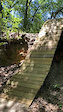
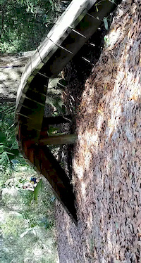
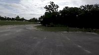
Photos of Mount Dora Mountain Bike
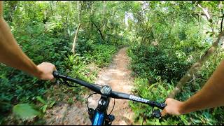
Videos of Mount Dora Mountain Bike
trail: Pure Adrenaline
0:14 |
332 |
Apr 1, 2023
trail: Pure Adrenaline
0:09 |
801 |
Feb 16, 2020
trail: Gravity Destroyer
2:44 |
233 |
Dec 18, 2018
trail: Florida Flow
7:26 |
30 |
Apr 20, 2026 , Mount Dora

12:46 |
57 |
May 4, 2025
5:28 |
198 |
Jan 27, 2023
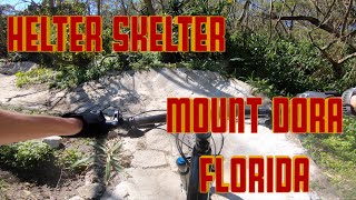
trail: Helter Skelter
6:13 |
1328 |
Jan 21, 2023 , Mount Dora
youtuber
![Best Things To Do In Orlando, Florida? (Travel...]()

14:22 |
254 |
Jan 18, 2023
Recent Trail Reports
Activity Feed
| username | action | type | title | date |
|---|---|---|---|---|
| ajveram | wishlist | region | activity #97363084 | Jun 19, 2026 @ 8:06pm 23 hours |
| Zackpipkin | add | photo | activity #96695125 and 11 more | Jun 10, 2026 @ 2:05pm Jun 10, 2026 |
| Zackpipkin | add | trail | activity #96694871 | Jun 10, 2026 @ 1:59pm Jun 10, 2026 |
| Edwinner23 | wishlist | region | activity #95994280 | May 31, 2026 @ 7:05pm May 31, 2026 |
| Alejandroz6F4v4 | add | report | activity #95173618 | May 21, 2026 @ 7:25am May 21, 2026 |
Recent Comments
| username | type | title | comment | date |
|---|---|---|---|---|
| trail | Tree down on trail at beginning of Harry Scary | Oct 18, 2025 @ 9:36am Oct 18, 2025 | ||
| report | I. | Jul 24, 2023 @ 9:08am Jul 24, 2023 | ||
| trail | Very fun jump line, a little bigger than the... | Jan 3, 2023 @ 11:14am Jan 3, 2023 | ||
| skillpark | Super good | Jun 22, 2020 @ 9:08am Jun 22, 2020 | ||
| trail | There is one semi difficult tree root to get... | Feb 21, 2020 @ 4:16am Feb 21, 2020 |
Local Badges
-

Epic Ride Climb 2k4 awarded -

Climbing 10k Badge35 awarded -

Climbing 100k Badge0 awarded -

Epic Ride Descent 2k4 awarded -

Descent 10k Badge35 awarded -

Descent 100k Badge1 awarded
Bike & Skill Parks
| name | type | city | rating |
|---|---|---|---|
| Skillzville at Mount Dora Mountain Bike Trail | skill park | Mount Dora | |
| Mount Dora Pump/Jump Park | skill park | Mount Dora |
Activity Type Stats
| activitytype | trails | distance | descent | descent distance | total vertical | rating | global rank | state rank | photos | reports | routes | ridelogs |
|---|---|---|---|---|---|---|---|---|---|---|---|---|
| Mountain Bike | 36 | 8 miles | 627 ft | 3 miles | 98 ft | #542 | #198 | 59 | 657 | 1 | 15,801 | |
| E-Bike | 36 | 8 miles | 627 ft | 3 miles | 98 ft | #635 | #739 | 488 | 983 | |||
| Gravel Bike | 1 | #512 | #1,071 | 26 | ||||||||
| Hike | 18 | 3 miles | 46 ft | 2,848 ft | 33 ft | #8,948 | #3,149 | 483 | 1 | 130 | ||
| Trail Running | 18 | 3 miles | 46 ft | 2,848 ft | 33 ft | #8,753 | #2,932 | 483 | 1 | 136 |
Frequently Asked Questions About Mount Dora
▼
What are the best places to ride in Mount Dora?
Mount Dora has 2 areas to explore for mountain biking. The top rated areas are:
▼
What are the highest rated mountain biking trails in Mount Dora?
The highest rated mountain biking trails in Mount Dora are:
- Gravity Destroyer (4.5/5)
- Florida Flow (4.5/5)
- Bridge Trail Connector (4.5/5)
- Extra Crispy (4.4/5)
- Rabbit Run (4.3/5)
▼
What is the best time of the year to ride in Mount Dora?
Based on ride log data, the most popular months to ride in Mount Dora are:
- February (126 activities)
- March (125 activities)
- July (120 activities)
▼
Where can I park to ride in Mount Dora?
There are 6 parking locations listed in Mount Dora. The most popular parking spots are:
- Parking Lot for Mount Dora Trail
- Adrenine Bike Works Parking Lot
- Mount Dora Flow Trail Parking Lot
- Baseball Fields Parking Lot/Overflow Mount Dora Trail Lot
- Parking
Activities
- By brenthillier
 NSMBA TRAILFORKS & contributors
 - Admins: OMBA, SORBA-O
- #14712 - 11,142 views
- mount dora activity log | embed map of Mount Dora mountain bike trails | mount dora mountain biking points of interest
Downloading of trail gps tracks in kml & gpx formats is enabled for Mount Dora.
You must login to download files.