close
-
Layers w
- Weather Layers
- Pro
- Pro
- Pro
- Pro
- Pro
- Pro
- More Layers
- Pro
- Pro
- Pro
- Pro
-
Upgrade to

3D
Trail Conditions
- Unknown
- Snow Groomed
- Snow Packed
- Snow Covered
- Snow Cover Partial
- Freeze/thaw Cycle
- Icy
- Prevalent Mud
- Wet
- Variable
- Ideal
- Dry
- Very Dry
Trail Flow (Ridden Direction)
Trailforks scans users ridelogs to determine the most popular direction each trail is ridden. A good flowing trail network will have most trails flowing in a single direction according to their intension.
The colour categories are based on what percentage of riders are riding a trail in its intended direction.
The colour categories are based on what percentage of riders are riding a trail in its intended direction.
- > 96%
- > 90%
- > 80%
- > 70%
- > 50%
- < 50%
- bi-directional trail
- no data
Trail Last Ridden
Trailforks scans ridelogs to determine the last time a trail was ridden.
- < 2 days
- < 1 week
- < 2 weeks
- < 1 month
- < 6 months
- > 6 months
Trail Ridden Direction
The intended direction a trail should be ridden.
- Downhill Only
- Downhill Primary
- Both Directions
- Uphill Primary
- Uphill Only
- One Direction
Contribute Details
Colors indicate trail is missing specified detail.
- Description
- Photos
- Description & Photos
- Videos
Trail Popularity ?
Trailforks scans ridelogs to determine which trails are ridden the most in the last 9 months.
Trails are compared with nearby trails in the same city region with a possible 25 colour shades.
Think of this as a heatmap, more rides = more kinetic energy = warmer colors.
- most popular
- popular
- less popular
- not popular
ATV/ORV/OHV Filter
Max Vehicle Width
inches
US Cell Coverage
Legend

Radar Time
Activity Recordings
Trailforks uses anonymized public activity data.
?
Activity Recordings
Trailforks uses anonymized public activity data.
?
Personal Heatmap
▶
Activity Types
all
/
none
▶
Options
2
Date range
month
–
Winter Trails
Warning
A routing network for winter maps does not exist. Selecting trails using the winter trails layer has been disabled.
Missing Trails
Most Popular
Least Popular
Trails are colored based on popularity. The more popular a trail is, the more red. Less popular trails trend towards green.
Jump Magnitude Heatmap
Heatmap of where riders jump on trails. Zoom in to see individual jumps, click circles to view jump details.
BC Backroad Status
![map legend]()
Service Road Atlas is a free to use, community-driven service for viewing and creating reports on the numerous back-country service roads around B.C. and Alberta.

Slope Aspect
Direction the slope faces
Trails Deemphasized
Trails are shown in grey.
Only show trails with no bike usage.
Suggested Layers
Based on selected activity type
Save the current map location and zoom level as your default home location whenever this page is loaded.
Save
No description for Mount Peel has been added yet!
Login or register to submit one.
 google parking directions
Primary Trail Type: Cross-Country
Land Status: City Managed
google parking directionsLinks
Activities Click to view
- Mountain Bike
41 trails
- E-Bike
17 trails
- Horse
5 trails
- Hike
27 trails
- Trail Running
27 trails
Region Details
- 18
- 1
- 18
- 3
- 1
Region Status
Caution as of Jun 28, 2025Stats
- Avg Trail Rating
- Trails (view details)
- 44
- Trails Mountain Bike
- 41
- Trails E-Bike
- 17
- Trails Horse
- 5
- Trails Hike
- 27
- Trails Trail Running
- 27
- Total Distance
- 21 miles
- Total Descent Distance
- 9 miles
- Total Descent
- 2,619 ft
- Total Vertical
- 524 ft
- Highest Trailhead
- 2,349 ft
- Reports
- 88
- Photos
- 27
- Ridden Counter
- 2,194
Popular Mount Peel Mountain Biking Trails
• 65 ★ 3.5 • 4,239 ft • 74 ft • 148 •
Moderately popular green difficulty singletrack. This mountain bike primary trail can be used one direction and has a easy overall physical rating with a 74 ft green climb. On average it takes 5 minutes to complete this trail.
• 65 ★ 4.2 • 1,831 ft • 14 ft • 148 •
Moderately popular green difficulty singletrack. This mountain bike primary trail can be used downhill only and has a easy overall physical rating. It features berm. Trail visibility is always easy to follow. On average it takes 2 minutes to complete this trail.
• 75 ★ 3.5 • 2,828 ft • 127 ft • 144 •
Popular green difficulty singletrack. This mountain bike primary trail can be used uphill only and has a easy overall physical rating with a 127 ft green climb. It features berm. Trail visibility is always easy to follow. On average it takes 4 minutes to complete this trail.
• 70 ★ 4.5 • 1 mile • 398 ft • 128 •
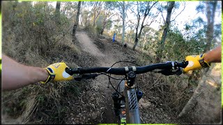
Gumbi Gumbi climb is a uphill only trail created by Trailworx. Almost perfectly smooth trail throughout.
• 50 ★ 3.7 • 4,045 ft • 45 ft • 79 •
Moderately popular green difficulty singletrack. This mountain bike primary trail can be used one direction. On average it takes 4 minutes to complete this trail.
• 70 ★ 0.0 • 3,097 ft • 32 ft • 60 •
Popular green difficulty singletrack. This mountain bike primary trail can be used one direction and has a easy overall physical rating with a 32 ft green climb. On average it takes 3 minutes to complete this trail.
• 50 ★ 0.0 • 184 ft • 0 ft • 57 •
Moderately popular green difficulty singletrack. This mountain bike primary trail can be used both directions. On average it takes minutes to complete this trail.
Photos of Mount Peel Mountain Bike
Videos of Mount Peel Mountain Bike
youtuber
![Being a MTB Youtuber]()

trail: Wakka Wakka 2
25:16 |
195 |
Aug 21, 2023 , Toowoomba
youtuber
![Being a MTB Youtuber]()

trail: Darla Trail (Climb)
25:16 |
131 |
Aug 21, 2023 , Toowoomba
youtuber
![Being a MTB Youtuber]()
trail: Wakka Wakka
25:16 |
162 |
Aug 21, 2023 , Toowoomba
youtuber
![Upgraded WAKKA WAKKA Trail | Mount Peel | Raw...]()

trail: Wakka Wakka
25:14 |
304 |
Jul 3, 2022 , Toowoomba
youtuber
![GUMBI GUMBI + WAKKA BUNDA | Mt Peel | RAW...]()

trail: Wakka Bunda Trail
3:23 |
154 |
May 24, 2022 , Toowoomba
youtuber
![GUMBI GUMBI + WAKKA BUNDA | Mt Peel | RAW...]()
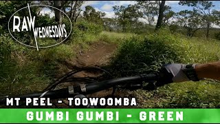
trail: Gumbi Gumbi
3:23 |
323 |
May 24, 2022 , Toowoomba
youtuber
![Mount Peel - Toowoomba | Raw Full Run 2022]()
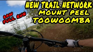
36:29 |
266 |
Apr 14, 2022
youtuber
![Darla Trail | Mt Peel | RAW WEDNESDAYS]()
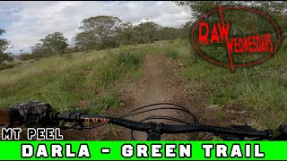
trail: Darla Trail
3:50 |
579 |
Nov 10, 2021 , Toowoomba
Recent Trail Reports
| status | trail | date | condition | info | user |
|---|---|---|---|---|---|
| Gumbi Gumbi (CLIMB) | Jun 28, 2025 @ 3:08am Jun 28, 2025 | Dry | AJ77 | ||
| Darla Trail | Jun 28, 2025 @ 3:07am Jun 28, 2025 | Dry | AJ77 | ||
| Darla Trail (Climb) | Jun 28, 2025 @ 3:05am Jun 28, 2025 | Dry | AJ77 | ||
| Wakka Bunda Trail | Jun 28, 2025 @ 3:00am Jun 28, 2025 | Ideal | AJ77 | ||
| Wakka Wakka | Jun 28, 2025 @ 2:59am Jun 28, 2025 | Ideal | AJ77 | ||
| Wakka Wakka 2 | Jun 28, 2025 @ 2:58am Jun 28, 2025 | Dry | AJ77 | ||
| Gumbi Gumbi | Apr 19, 2025 @ 8:56am Apr 19, 2025 | Dry | W13 | ||
| Access Road | Jan 2, 2025 @ 5:56pm Jan 2, 2025 | Very Dry | Johnnytheg1 | ||
| Access Road | Jan 2, 2025 @ 5:56pm Jan 2, 2025 | Very Dry | Johnnytheg1 | ||
| Wakka Bunda Trail | Jan 2, 2025 @ 5:56pm Jan 2, 2025 | Very Dry | Johnnytheg1 |
Activity Feed
| username | action | type | title | date |
|---|---|---|---|---|
| N311V | ridden | trail | activity #92906648 and 1 more | Apr 18, 2026 @ 5:22pm Apr 18, 2026 |
| N311V | ridden | trail | activity #92301108 and 1 more | Apr 9, 2026 @ 9:04pm Apr 9, 2026 |
| IsaacNgboTW | ridden | trail | activity #90960525 | Mar 20, 2026 @ 7:55pm Mar 20, 2026 |
| michaelu79 | ridden | trail | activity #83425896 and 5 more | Nov 2, 2025 @ 2:09am Nov 2, 2025 |
| emcghie | comment | report | activity #74775912 | Jun 28, 2025 @ 5:27pm Jun 28, 2025 |
Recent Comments
| username | type | title | comment | date |
|---|---|---|---|---|
| report | Bo90jh | Jun 28, 2025 @ 5:27pm Jun 28, 2025 | ||
| trail | Well overgrown didn’t have my brush cutter on me | Feb 9, 2024 @ 11:59pm Feb 9, 2024 | ||
| report | Good ride, had recording while I had to check... | Aug 10, 2023 @ 8:47pm Aug 10, 2023 | ||
| report | Darla downhill is perfect at the minute - In... | Jul 25, 2022 @ 12:09am Jul 25, 2022 | ||
| trail | this is a pirate trail and shouldn't have been... | Apr 4, 2022 @ 4:29pm Apr 4, 2022 |
Nearby Areas
| name | distance | ||||
|---|---|---|---|---|---|
| Neilson Park | 4.8 km | ||||
| Picnic Point Parklands | 5 | 5.9 km | |||
| Redwood Park | 6.2 km | ||||
| Jubilee Park | 15 | 8 | 10 | 2 | 6.8 km |
| Mountain Bike Mecca | 25.2 km |
Local Badges
-

Completionist1 awarded
Activity Type Stats
| activitytype | trails | distance | descent | descent distance | total vertical | rating | global rank | state rank | photos | reports | routes | ridelogs |
|---|---|---|---|---|---|---|---|---|---|---|---|---|
| Mountain Bike | 41 | 19 miles | 2,083 ft | 8 miles | 525 ft | #4,697 | #230 | 27 | 88 | 2,289 | ||
| E-Bike | 17 | 12 miles | 1,673 ft | 6 miles | 417 ft | #5,159 | #267 | 80 | 198 | |||
| Horse | 5 | 4 miles | 633 ft | 2 miles | 417 ft | #1,171 | #44 | |||||
| Hike | 27 | 12 miles | 1,348 ft | 5 miles | 525 ft | #8,453 | #281 | 33 | 70 | |||
| Trail Running | 27 | 12 miles | 1,348 ft | 5 miles | 525 ft | #7,756 | #273 | 33 | 167 |
Frequently Asked Questions About Mount Peel
▼
What are the highest rated mountain biking trails in Mount Peel?
The highest rated mountain biking trails in Mount Peel are:
- Darla Trail (4.2/5)
- Gumbi Gumbi (CLIMB) (4.1/5)
- Gumbi Gumbi (4.1/5)
- Bunda Trail (3.9/5)
- Darla Trail (Climb) (3.9/5)
▼
What is the best time of the year to ride in Mount Peel?
Based on ride log data, the most popular months to ride in Mount Peel are:
- August (24 activities)
- September (14 activities)
- December (13 activities)
▼
Where can I park to ride in Mount Peel?
There are 3 parking locations listed in Mount Peel. The most popular parking spots are: View all parking and trailhead locations on the map to plan your visit.
▼
What is the longest trail in Mount Peel?
The longest trail in Mount Peel is Wakka Wakka 2 at 2.2 miles. View all trails sorted by distance.
Activities
Trails
Points of Interest
- By Shadoze & contributors
- Admins: TMBC
- #29257 - 11,316 views
- mount peel activity log | embed map of Mount Peel mountain bike trails | mount peel mountain biking points of interest
Downloading of trail gps tracks in kml & gpx formats is enabled for Mount Peel.
You must login to download files.