close
-
Layers w
- Weather Layers
- Pro
- Pro
- Pro
- Pro
- Pro
- Pro
- More Layers
- Pro
- Pro
- Pro
- Pro
-
Upgrade to

3D
Trail Conditions
- Unknown
- Snow Groomed
- Snow Packed
- Snow Covered
- Snow Cover Partial
- Freeze/thaw Cycle
- Icy
- Prevalent Mud
- Wet
- Variable
- Ideal
- Dry
- Very Dry
Trail Flow (Ridden Direction)
Trailforks scans users ridelogs to determine the most popular direction each trail is ridden. A good flowing trail network will have most trails flowing in a single direction according to their intension.
The colour categories are based on what percentage of riders are riding a trail in its intended direction.
The colour categories are based on what percentage of riders are riding a trail in its intended direction.
- > 96%
- > 90%
- > 80%
- > 70%
- > 50%
- < 50%
- bi-directional trail
- no data
Trail Last Ridden
Trailforks scans ridelogs to determine the last time a trail was ridden.
- < 2 days
- < 1 week
- < 2 weeks
- < 1 month
- < 6 months
- > 6 months
Trail Ridden Direction
The intended direction a trail should be ridden.
- Downhill Only
- Downhill Primary
- Both Directions
- Uphill Primary
- Uphill Only
- One Direction
Contribute Details
Colors indicate trail is missing specified detail.
- Description
- Photos
- Description & Photos
- Videos
Trail Popularity ?
Trailforks scans ridelogs to determine which trails are ridden the most in the last 9 months.
Trails are compared with nearby trails in the same city region with a possible 25 colour shades.
Think of this as a heatmap, more rides = more kinetic energy = warmer colors.
- most popular
- popular
- less popular
- not popular
ATV/ORV/OHV Filter
Max Vehicle Width
inches
US Cell Coverage
Legend

Radar Time
Activity Recordings
Trailforks uses anonymized public activity data.
?
Activity Recordings
Trailforks uses anonymized public activity data.
?
Personal Heatmap
▶
Activity Types
all
/
none
▶
Options
2
Date range
month
–
Winter Trails
Warning
A routing network for winter maps does not exist. Selecting trails using the winter trails layer has been disabled.
Missing Trails
Most Popular
Least Popular
Trails are colored based on popularity. The more popular a trail is, the more red. Less popular trails trend towards green.
Jump Magnitude Heatmap
Heatmap of where riders jump on trails. Zoom in to see individual jumps, click circles to view jump details.
BC Backroad Status
![map legend]()
Service Road Atlas is a free to use, community-driven service for viewing and creating reports on the numerous back-country service roads around B.C. and Alberta.

Slope Aspect
Direction the slope faces
Trails Deemphasized
Trails are shown in grey.
Only show trails with no bike usage.
Suggested Layers
Based on selected activity type
Save the current map location and zoom level as your default home location whenever this page is loaded.
SaveBike Park Closed for Season. Opens on June 26
Elevate your summer at the Mt. Washington Bike Park. Open for daily operations starting June 26, the Hawk Six Pack will be spinning for riders daily during the summer until the last weekend of September. Hours at Mt Washington
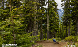
Mount Washington Alpine Resort is the embodiment of Canada's spectacular West Coast. Moss-laden Hemlock and Yellow Cedar tower over an extensive network of DH mountain bike trails that range from fast and flowy to steep and technical. Add a jaw-dropping view that span the Island's rugged mountains to the blue waters of the Pacific and you have a destination that riding dreams are made of
Mount Washington has put some serious focus on the beginner trail network and introduced the Panda Gardens trail, and the rebirth of blue flow trail Hustler in August.
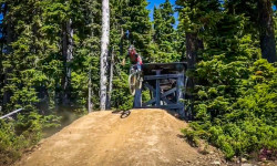
The resort's signature expert freeride trail, Back in Black has been heralded as the perfect blend of dirt and wood. If you're into perfectly sculpted dirt jumps, big drops, and even bigger wall rides with more flow than the kitchen tap then look no further. Back in Black will soon make it to your top ten trails list.
2 High-Speed Chairlifts, The Hawk Six Pack, & The Eagle Quad
18% Easiest, 35% More Difficult, 47% Most Difficult
Mount Washington Alpine Resort is the embodiment of Canada's spectacular West Coast. Moss-laden Hemlock and Yellow Cedar tower over an extensive network of DH mountain bike trails that range from fast and flowy to steep and technical. Add a jaw-dropping view that span the Island's rugged mountains to the blue waters of the Pacific and you have a destination that riding dreams are made of
Mount Washington has put some serious focus on the beginner trail network and introduced the Panda Gardens trail, and the rebirth of blue flow trail Hustler in August.
The resort's signature expert freeride trail, Back in Black has been heralded as the perfect blend of dirt and wood. If you're into perfectly sculpted dirt jumps, big drops, and even bigger wall rides with more flow than the kitchen tap then look no further. Back in Black will soon make it to your top ten trails list.
2 High-Speed Chairlifts, The Hawk Six Pack, & The Eagle Quad
18% Easiest, 35% More Difficult, 47% Most Difficult
Primary Trail Type: All-Mountain & Downhill
Land Status: Ski Resort
 google parking directions
Links
Activities Click to view
- Mountain Bike
25 trails
Bike Park Details
- 1
- 2
- 12
- 6
- 4
Region Status
Open as of Jun 7, 2026- Day Ticket
- $64 CAD
- Uplift Type
- Chair Lift
- Season start
- Jun 26
- Season end
- Sep 27
Stats
- Avg Trail Rating
- Global Ranking
- #807
- State Ranking
- #69
- Trails (view details)
- 26
- Trails Mountain Bike
- 25
- Trails E-Bike
- 2
- Trails Hike
- 2
- Trails Trail Running
- 1
- Total Distance
- 17 miles
- Total Descent
- 8,609 ft
- Total Vertical
- 4,415 ft
- Highest Trailhead
- 5,161 ft
- Reports
- 1,118
- Photos
- 256
- Ridden Counter
- 30,100
Articles

Event Recap: Chainsaw’s Legacy Lives On at the Stevie Smith Memorial DH
Sep 5, 2025 from pinkbike.com
Stevie’s legacy burns bright at Mount Washington with a weekend of top-tier racing and community.

Event Preview: Chainsaw’s Legacy Lives On at the Stevie Smith Memorial DH & VI Bike Fest
Aug 26, 2025 from pinkbike.com
From Canada Cup racing to the crowd favourite Whip Off, Mount Washington celebrates the icon this upcoming Labour Day weekend.
Race Report: Emmy Lan & Jack Menzies Win Canadian Enduro Series Round 4 - Vancouver Island
Jul 13, 2022 from pinkbike.com
The first ever Canadian Enduro Series event on the island.
POV Video: Groms Ride Mount Washington Bike Park on Opening Day
Jun 29, 2021 from pinkbike.com
The kids are vlogging and sending!
Popular Mount Washington Bike Park Trails
• 85 ★ 4.2 • 2 miles • 6 ft • 1,378 •
Highly rated popular blue difficulty singletrack. This mountain bike primary trail can be used downhill only and has a moderate overall physical rating. It features berm, bridge, jump and rock garden. On average it takes 7 minutes to complete this trail.
• 90 ★ 4.2 • 2,405 ft • 3 ft • 1,371 •
Highly rated popular blue difficulty singletrack. This mountain bike primary trail can be used downhill only and has a moderate overall physical rating. It features berm, bridge, drop, jump and rock face. Trail visibility is always easy to follow. On average it takes 2 minutes to complete this trail.
• 90 ★ 3.5 • 653 ft • 0 ft • 1,253 •
Popular black diamond difficulty singletrack. This mountain bike primary trail can be used downhill only and has a hard overall physical rating. On average it takes minutes to complete this trail.
• 100 ★ 4.6 • 1,660 ft • 0 ft • 1,253 •
Starts with a step down gap into a left turn followed by a right. Another left turn featuring a step down in it. Then a nice hip-style jump to finish ‘er off before pedalling across to merge with Highway 19.
• 80 ★ 3.5 • 1,437 ft • 0 ft • 1,154 •
Inspired by our friends in Cumberland this blue square tech trail features a small waterfall, a creek and great alpine views of Strathcona Park. A great addition for riders to access the chair from the lodge. **3 new berms near the bottom
• 100 ★ 4.1 • 1 mile • 0 ft • 1,114 •
Slalom style trail, doubles and drops. Not as hard as it once was due to gaps being filled with wood or dirt to decrease the consequences, but still the most difficult trail on Mt Washington. The second drop is the largest (roughly 8...
• 55 ★ 3.5 • 4,130 ft • 56 ft • 1,079 •
This trail features lots of tight berms. A couple steeper sections but nothing so steep that an advanced beginner can't handle. The steep sections are comparable to the steep section of just after crossing under Hawk liftline.
• 95 ★ 4.1 • 1,322 ft • 0 ft • 1,072 •
Highly rated popular black diamond difficulty machine groomed. This mountain bike primary trail can be used downhill only and has a hard overall physical rating. It features berm, drop, jump, ladder bridge and rock garden. Trail visibility is always easy to follow. On average it takes 1 minutes to complete this trail.
Mountain Bike Routes
1 mile • 0 • Point to Point • Race •
7 miles • 2,882 ft • 0 • Point to Point • Race •
Above the treeline at Mt Washington! You’ll be treated to some unbelievable views of the Comox Valley...
• 25 miles • 9,134 ft • 30 •
• 30 miles • 10,212 ft • 38 •
• 27 miles • 2,461 ft • 11 •
• 11 miles • 3,696 ft • 12 •
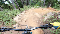
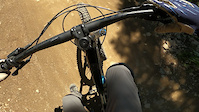
Photos of Mount Washington Bike Park Mountain Bike
Videos of Mount Washington Bike Park Mountain Bike
trail: Upper Helter Skelter
0:54 |
71 |
Aug 4, 2025
trail: Back In Black
0:19 |
136 |
Sep 18, 2022
trail: Back In Black
4:19 |
125 |
Aug 13, 2022
trail: Time Warp
2:31 |
156 |
Jul 28, 2022
trail: The Wiz
0:09 |
186 |
Aug 20, 2021
trail: Hustler
0:00 |
122 |
Jul 26, 2021

trail: Greenline
6:44 |
690 |
Jul 23, 2021

trail: HWY 19
8:49 |
157 |
Jul 20, 2021
Recent Trail Reports
| status | trail | date | condition | info | user |
|---|---|---|---|---|---|
| Finger Trail XC | Jun 7, 2026 @ 7:50pm (America/Vancouver) Jun 7, 2026 | Unknown | rcampbell14 | ||
| Upper Helter Skelter | Aug 29, 2025 @ 11:17pm Aug 29, 2025 | Very Dry | Dubnyk TRAILFORKS | ||
| Monster Mile | Aug 29, 2025 @ 11:17pm Aug 29, 2025 | Very Dry | Dubnyk TRAILFORKS | ||
| Helter Skelter | Aug 29, 2025 @ 11:17pm Aug 29, 2025 | Very Dry | Dubnyk TRAILFORKS | ||
| Riptide Ridge | Aug 17, 2025 @ 10:47am Aug 17, 2025 | Ideal | scaliose | ||
| Blue Hammer | Aug 17, 2025 @ 10:47am Aug 17, 2025 | Ideal | scaliose | ||
| Lower Time Warp | Aug 17, 2025 @ 10:47am Aug 17, 2025 | Ideal | scaliose | ||
| The Wiz Lower | Aug 17, 2025 @ 10:47am Aug 17, 2025 | Ideal | scaliose | ||
| The Wiz | Aug 17, 2025 @ 10:47am Aug 17, 2025 | Ideal | scaliose | ||
| Panda Gardens | Aug 17, 2025 @ 10:47am Aug 17, 2025 | Ideal | scaliose |
Activity Feed
| username | action | type | title | date |
|---|---|---|---|---|
| Sudlow642 | ridden | trail | activity #97304398 | Jun 19, 2026 @ 2:42am 1 day |
| Sudlow642 | ridden | trail | activity #97011538 | Jun 14, 2026 @ 4:14pm Jun 14, 2026 |
| remymetailler | add | video | activity #96631438 | Jun 9, 2026 @ 3:00pm Jun 9, 2026 |
| rcampbell14 | add | report | activity #96517263 | Jun 7, 2026 @ 7:50pm Jun 7, 2026 |
| rcampbell14 | add | photo | activity #96366927 | Jun 6, 2026 @ 7:10am Jun 6, 2026 |
Recent Comments
| username | type | title | comment | date |
|---|---|---|---|---|
| trail | Wouldn’t suggest this is a green. Some... | Feb 7, 2026 @ 6:12pm Feb 7, 2026 | ||
| trail | Awesome trail. Jumps are very fun, but there... | Sep 21, 2025 @ 9:42am Sep 21, 2025 | ||
| trail | Canada cup racecourse. Gets blown out and... | Sep 21, 2025 @ 9:16am Sep 21, 2025 | ||
| trail | They added a jump section half way down the... | Jul 6, 2025 @ 6:59pm Jul 6, 2025 | ||
| trail | Wicked Trail!! Without the drop middle drop... | Sep 1, 2024 @ 12:53pm Sep 1, 2024 |
Nearby Areas
| name | distance | ||||
|---|---|---|---|---|---|
| Forbidden Plateau | 10 | 18 | 50 | 4 | 10.1 km |
| Wildwood Interpretive Forest | 7 | 10.4 km | |||
| Nymph Falls Park | 11 km | ||||
| Oyster River | 10 | 13 | 3 | 11.1 km | |
| Oyster River Nature Park | 5 | 11.9 km |
Local Badges
-

Completionist1 awarded
Bike & Skill Parks
| name | type | city | rating |
|---|---|---|---|
| Warm Up Skills Park | skill park | Courtenay | |
| West Skills Area | skill park | Courtenay |
Local Products
Activity Type Stats
| activitytype | trails | distance | descent | descent distance | total vertical | rating | global rank | state rank | photos | reports | routes | ridelogs |
|---|---|---|---|---|---|---|---|---|---|---|---|---|
| Mountain Bike | 25 | 16 miles | 8,363 ft | 13 miles | 1,516 ft | #807 | #69 | 256 | 1,117 | 2 | 7,981 | |
| E-Bike | 2 | 3 miles | 358 ft | 2 miles | 171 ft | #2,698 | #120 | 658 | 59 | |||
| Hike | 2 | 1 mile | 246 ft | 1,542 ft | 3,150 ft | #9,344 | #346 | 663 | 841 | |||
| Trail Running | 1 | 3,953 ft | 246 ft | 1,542 ft | 197 ft | #9,313 | #340 | 661 | 1 | 186 |
Frequently Asked Questions About Mount Washington Bike Park
▼
What are the highest rated mountain biking trails in Mount Washington Bike Park?
The highest rated mountain biking trails in Mount Washington Bike Park are:
- Monster Mile (4.5/5)
- The Wiz Lower (4.4/5)
- Step Brother (4.3/5)
- Helter Skelter (4.2/5)
- HWY 19 (4.2/5)
▼
What is the best time of the year to ride in Mount Washington Bike Park?
Based on ride log data, the most popular months to ride in Mount Washington Bike Park are:
- July (265 activities)
- August (241 activities)
- September (149 activities)
▼
Where can I park to ride in Mount Washington Bike Park?
There are 1 parking locations listed in Mount Washington Bike Park. The most popular parking spots are:
▼
What is the longest trail in Mount Washington Bike Park?
The longest trail in Mount Washington Bike Park is Finger Trail XC at 2.9 miles. View all trails sorted by distance.
Trails
- Hard trails in Mount Washington Bike Park
- Easy trails in Mount Washington Bike Park
- Favorite trails in Mount Washington Bike Park
- Most ridden trails in Mount Washington Bike Park
- Singletrack in Mount Washington Bike Park
- Viewpoint trails in Mount Washington Bike Park
- Trails with technical features in Mount Washington Bike Park
- Race routes in Mount Washington Bike Park
- By canadaka
 Trailforks & contributors
 - Admins: MWBP, mountwashington
- #1049 - 37,732 views
- mount washington bike park activity log | embed map of Mount Washington Bike Park mountain bike trails | mount washington bike park mountain biking points of interest
Downloading of trail gps tracks in kml & gpx formats is enabled for Mount Washington Bike Park.
You must login to download files.