close
-
Layers w
- Weather Layers
- Pro
- Pro
- Pro
- Pro
- Pro
- Pro
- More Layers
- Pro
- Pro
- Pro
- Pro
-
Upgrade to

3D
Trail Conditions
- Unknown
- Snow Groomed
- Snow Packed
- Snow Covered
- Snow Cover Partial
- Freeze/thaw Cycle
- Icy
- Prevalent Mud
- Wet
- Variable
- Ideal
- Dry
- Very Dry
Trail Flow (Ridden Direction)
Trailforks scans users ridelogs to determine the most popular direction each trail is ridden. A good flowing trail network will have most trails flowing in a single direction according to their intension.
The colour categories are based on what percentage of riders are riding a trail in its intended direction.
The colour categories are based on what percentage of riders are riding a trail in its intended direction.
- > 96%
- > 90%
- > 80%
- > 70%
- > 50%
- < 50%
- bi-directional trail
- no data
Trail Last Ridden
Trailforks scans ridelogs to determine the last time a trail was ridden.
- < 2 days
- < 1 week
- < 2 weeks
- < 1 month
- < 6 months
- > 6 months
Trail Ridden Direction
The intended direction a trail should be ridden.
- Downhill Only
- Downhill Primary
- Both Directions
- Uphill Primary
- Uphill Only
- One Direction
Contribute Details
Colors indicate trail is missing specified detail.
- Description
- Photos
- Description & Photos
- Videos
Trail Popularity ?
Trailforks scans ridelogs to determine which trails are ridden the most in the last 9 months.
Trails are compared with nearby trails in the same city region with a possible 25 colour shades.
Think of this as a heatmap, more rides = more kinetic energy = warmer colors.
- most popular
- popular
- less popular
- not popular
ATV/ORV/OHV Filter
Max Vehicle Width
inches
US Cell Coverage
Legend

Radar Time
Activity Recordings
Trailforks uses anonymized public activity data.
?
Activity Recordings
Trailforks uses anonymized public activity data.
?
Personal Heatmap
▶
Activity Types
all
/
none
▶
Options
2
Date range
month
–
Winter Trails
Warning
A routing network for winter maps does not exist. Selecting trails using the winter trails layer has been disabled.
Missing Trails
Most Popular
Least Popular
Trails are colored based on popularity. The more popular a trail is, the more red. Less popular trails trend towards green.
Jump Magnitude Heatmap
Heatmap of where riders jump on trails. Zoom in to see individual jumps, click circles to view jump details.
BC Backroad Status
![map legend]()
Service Road Atlas is a free to use, community-driven service for viewing and creating reports on the numerous back-country service roads around B.C. and Alberta.

Slope Aspect
Direction the slope faces
Trails Deemphasized
Trails are shown in grey.
Only show trails with no bike usage.
Suggested Layers
Based on selected activity type
Save the current map location and zoom level as your default home location whenever this page is loaded.
Save
No description for Mt. Juliet has been added yet!
Login or register to submit one.
Activities Click to view
- Mountain Bike
39 trails
- E-Bike
42 trails
- Gravel Bike
0 trails
- Adaptive Bike
0 trails
- Winter Fat Bike
0 trails
- Hike
49 trails
- Trail Running
45 trails
Region Details
- 7
- 14
- 10
- 7
- 1
Region Status
Caution as of May 31, 2026Stats
- Avg Trail Rating
- Trails (view details)
- 46
- Trails Mountain Bike
- 42
- Trails E-Bike
- 42
- Trails Hike
- 49
- Trails Trail Running
- 45
- Total Distance
- 44 miles
- Total Descent
- 2,358 ft
- Total Vertical
- 271 ft
- Highest Trailhead
- 673 ft
- Reports
- 793
- Photos
- 147
- Ridden Counter
- 2,128
Sub Regions
-
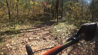
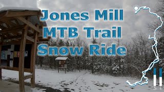
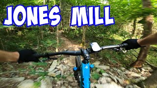
Jones Mill Mountain Bike Trail
- 8
- 4
-
Shutes Branch Recreation Area
- 2
- 3
- 1
Popular Mt. Juliet Mountain Biking Trails
• 95 ★ 4.5 • 1 mile • 92 ft • 200 •
The Orange Loop takes you to the top of "Bald Knob." The climb can be challenging, especially when wet. The descent from the top is a series of long switch backs allowing you to gain speed - so watch out for the sharp turns.
• 100 ★ 0.0 • 4,951 ft • 40 ft • 194 •
Mostly gravel based trail with few tech obstacles and mild climbs. Often ridden full speed.
• 100 ★ 4.0 • 4,839 ft • 33 ft • 193 •
A very short climb is followed by a descent. After a tight left switchback, you make your way up a climb that may be considered somewhat long and technical for beginners. But don't give up as you passed the hardest part. At the top you...
• 80 ★ 3.0 • 2 miles • 83 ft • 183 •
Popular green difficulty singletrack. This mountain bike primary trail can be used both directions and has a moderate overall physical rating with a 83 ft green climb. On average it takes 18 minutes to complete this trail.
• 80 ★ 3.0 • 3,777 ft • 120 ft • 175 •
Campground graveyard with technical rocky trails. Flowy at the start and rocky at the end. Big rocks all over the trail. Super fun for this northern girl on a Fat bike.
• 75 ★ 2.0 • 5,255 ft • 207 ft • 170 •
Popular blue difficulty singletrack. This mountain bike primary trail can be used one direction. On average it takes 12 minutes to complete this trail.
• 75 ★ 2.0 • 2 miles • 263 ft • 153 •
Popular blue difficulty singletrack. This mountain bike primary trail can be used one direction. On average it takes 19 minutes to complete this trail.
Mt. Juliet Mountain Bike Routes
Jones Mill 9 Mile Loop with Road Featured
9 miles • 413 ft • 7 • Loop •
This loop includes the far end of the that is normally skipped if you ride the Red trail. In this route,...
Jones Mill 8 Mile Loop Whole Trail Featured
8 miles • 384 ft • 6 • Loop •
Moderate skill and strength is best to enjoy Jones Mill. Beginners may find themselves walking thru some...
10 miles • 484 ft • 9 • Loop •
10 mile route that takes you back on and covers sections that are great - but often skipped when you ride .
1 mile • 68 ft • 3 • Loop •
This is a great route for a quick warm-up or cool down. The "Shortcut" is not ridden frequently but is a...
6 miles • 233 ft • 6 •
First, the trail is supposed to be only CCW. But if the lower part, closer to the lake is wet... or Bald...
9 miles • 450 ft • 8 • Loop •
This loop includes the far end of the that is normally skipped if you ride the Red trail.
Photos of Mt. Juliet Mountain Bike
Videos of Mt. Juliet Mountain Bike

trail: Shutes Branch (Beg)
24:55 |
97 |
Jan 4, 2025 , Mt. Juliet

11:43 |
185 |
Jan 6, 2024

12:02 |
142 |
Jan 6, 2024
57:25 |
229 |
May 14, 2023
13:09 |
168 |
May 14, 2023
youtuber
![Fuel Woes - Staying Local Pt.2 | JONES MILL Trails]()

18:32 |
130 |
May 14, 2023
16:59 |
226 |
May 14, 2023
youtuber
![HEAVY RIDER vs LIGHTWEIGHT BIKE, can it still...]()

19:00 |
261 |
Mar 24, 2023
Recent Trail Reports
Activity Feed
| username | action | type | title | date |
|---|---|---|---|---|
| l4j20 | ridden | route | activity #96620495 | Jun 9, 2026 @ 11:46am Jun 9, 2026 |
| hillmakeitbetter | add | report | activity #95965823 | May 31, 2026 @ 12:05pm May 31, 2026 |
| hillmakeitbetter | comment | report | activity #95940882 | May 31, 2026 @ 8:04am May 31, 2026 |
| ajmtbtn | add | report | activity #95896663 and 3 more | May 30, 2026 @ 4:39pm May 30, 2026 |
| teragambill00 | wishlist | route | activity #95365880 | May 23, 2026 @ 4:48pm May 23, 2026 |
Recent Comments
| username | type | title | comment | date |
|---|---|---|---|---|
| report | Musta been cleared. Didn't see it. | May 31, 2026 @ 8:04am May 31, 2026 | ||
| report | As of 1/23/2025, this tree HAS completely fallen. | Jan 26, 2025 @ 6:56am Jan 26, 2025 | ||
| report | Thanks for the report & glad ya got to... | Nov 23, 2024 @ 7:00pm Nov 23, 2024 | ||
| report | Got bottom log cut & you can ride thru. ... | Sep 30, 2024 @ 5:48pm Sep 30, 2024 | ||
| report | Need to evaluate options. Back cut then top... | Sep 30, 2024 @ 5:39pm Sep 30, 2024 |
Local Badges
-

Epic Mountain Bike Climb 2k1 awarded -

Climbing 10k Badge3 awarded -

Mountain Biking 100k Badge0 awarded -

Epic Ride Descent 2k1 awarded -

Descent 10k Badge3 awarded -

Descent 100k Badge0 awarded
Activity Type Stats
| activitytype | trails | distance | descent | descent distance | total vertical | rating | global rank | state rank | photos | reports | routes | ridelogs |
|---|---|---|---|---|---|---|---|---|---|---|---|---|
| Mountain Bike | 39 | 35 miles | 2,116 ft | 12 miles | 272 ft | #5,117 | #1,728 | 147 | 795 | 17 | 3,250 | |
| E-Bike | 42 | 35 miles | 2,116 ft | 12 miles | 272 ft | #3,838 | #1,290 | 791 | 16 | 140 | ||
| Hike | 49 | 44 miles | 2,359 ft | 14 miles | 272 ft | #5,121 | #1,806 | 1 | 798 | 16 | 252 | |
| Trail Running | 45 | 37 miles | 2,152 ft | 12 miles | 272 ft | #5,345 | #1,682 | 798 | 15 | 326 |
Frequently Asked Questions About Mt. Juliet
▼
What are the best places to ride in Mt. Juliet?
Mt. Juliet has 2 areas to explore for mountain biking. The top rated areas are:
▼
What are the highest rated mountain biking trails in Mt. Juliet?
The highest rated mountain biking trails in Mt. Juliet are:
- Red Line Alt Out To Boat Dock (4.1/5)
- Orange Line (4/5)
- Blue Line (4/5)
- Shutes Branch (Beg) (3.8/5)
- The Hillside (3.7/5)
▼
What is the best time of the year to ride in Mt. Juliet?
Based on ride log data, the most popular months to ride in Mt. Juliet are:
- August (36 activities)
- March (31 activities)
- November (30 activities)
▼
Where can I park to ride in Mt. Juliet?
There are 13 parking locations listed in Mt. Juliet. The most popular parking spots are:
- Jones Mill Parking Lot
- Shutes Branch Trailhead
- Parking
- Eagle Park Trailhead Parking
- Charlie Daniels Park Parking
Activities
Trails
Points of Interest
- By CoveStiffee & contributors
- Admins: SORBAMIDTN, trail13tl
- #10454 - 4,400 views
- mt. juliet activity log | embed map of Mt. Juliet mountain bike trails | mt. juliet mountain biking points of interest polygons
Downloading of trail gps tracks in kml & gpx formats is enabled for Mt. Juliet.
You must login to download files.