close
-
Layers w
- Weather Layers
- Pro
- Pro
- Pro
- Pro
- Pro
- Pro
- More Layers
- Pro
- Pro
- Pro
- Pro
-
Upgrade to

3D
Trail Conditions
- Unknown
- Snow Groomed
- Snow Packed
- Snow Covered
- Snow Cover Partial
- Freeze/thaw Cycle
- Icy
- Prevalent Mud
- Wet
- Variable
- Ideal
- Dry
- Very Dry
Trail Flow (Ridden Direction)
Trailforks scans users ridelogs to determine the most popular direction each trail is ridden. A good flowing trail network will have most trails flowing in a single direction according to their intension.
The colour categories are based on what percentage of riders are riding a trail in its intended direction.
The colour categories are based on what percentage of riders are riding a trail in its intended direction.
- > 96%
- > 90%
- > 80%
- > 70%
- > 50%
- < 50%
- bi-directional trail
- no data
Trail Last Ridden
Trailforks scans ridelogs to determine the last time a trail was ridden.
- < 2 days
- < 1 week
- < 2 weeks
- < 1 month
- < 6 months
- > 6 months
Trail Ridden Direction
The intended direction a trail should be ridden.
- Downhill Only
- Downhill Primary
- Both Directions
- Uphill Primary
- Uphill Only
- One Direction
Contribute Details
Colors indicate trail is missing specified detail.
- Description
- Photos
- Description & Photos
- Videos
Trail Popularity ?
Trailforks scans ridelogs to determine which trails are ridden the most in the last 9 months.
Trails are compared with nearby trails in the same city region with a possible 25 colour shades.
Think of this as a heatmap, more rides = more kinetic energy = warmer colors.
- most popular
- popular
- less popular
- not popular
ATV/ORV/OHV Filter
Max Vehicle Width
inches
US Cell Coverage
Legend

Radar Time
Activity Recordings
Trailforks uses anonymized public activity data.
?
Activity Recordings
Trailforks uses anonymized public activity data.
?
Personal Heatmap
▶
Activity Types
all
/
none
▶
Options
2
Date range
month
–
Winter Trails
Warning
A routing network for winter maps does not exist. Selecting trails using the winter trails layer has been disabled.
Missing Trails
Most Popular
Least Popular
Trails are colored based on popularity. The more popular a trail is, the more red. Less popular trails trend towards green.
Jump Magnitude Heatmap
Heatmap of where riders jump on trails. Zoom in to see individual jumps, click circles to view jump details.
BC Backroad Status
![map legend]()
Service Road Atlas is a free to use, community-driven service for viewing and creating reports on the numerous back-country service roads around B.C. and Alberta.

Slope Aspect
Direction the slope faces
Trails Deemphasized
Trails are shown in grey.
Only show trails with no bike usage.
Suggested Layers
Based on selected activity type
Save the current map location and zoom level as your default home location whenever this page is loaded.
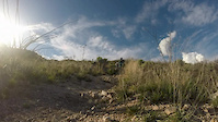
SavePusch Ridge towers over Tucson and the surrounding desert as one of the most prominent features of the Santa Catalina Mountains. With its lower slopes dotted saguaro cactus and its upper reaches dark Douglas-fir, this unmistakable landmark makes the point that this is a land of extremes in biodiversity as well as topography. Within the 56,933-acre Wilderness, elevations range from 2,800 to 8,800 feet. Deep canyons separated by razorback ridges crease the slopes. From the floor of Sabino Canyon to the upper slopes of Mt. Lemmon, life zones vary from Sonoran desert to subalpine forest. The wildlife community that inhabits such a varied setting is diverse and finds few rivals. An extensive trail network offers opportunities for day to extended trips. While its convenient location makes Pusch Ridge Wilderness easily accessible you can still find solitude and primitive surroundings
source: Pusch Wilderness
 google parking directions
 Disclaimer:
No bikes or motorized vehicles. Dogs and other pets are not allowed within the Pusch Ridge Wilderness due to a closure to protect Desert Big Horn Sheep.The Pusch Ridge Wilderness Sheep Closure Area includes trailheads for Ventana Canyon, Finger Rock, Pima Canyon, Linda Vista, and portions of Romero, including Romero Pools, and the Sutherland Trail accessed via Catalina State Park.
Activities Click to view
- Mountain Bike
10 trails
- Horse
48 trails
- Hike
55 trails
- Trail Running
55 trails
- Dirtbike/Moto
4 trails
- ATV/ORV/OHV
4 trails
Region Details
- 5
- 1
- 2
- 1
Region Status
Caution as of May 13, 2026Local Trail Association
Stats
- Avg Trail Rating
- Trails (view details)
- 54
- Trails Mountain Bike
- 10
- Trails E-Bike
- 2
- Trails Horse
- 48
- Trails Hike
- 55
- Trails Trail Running
- 55
- Trails Dirtbike/Moto
- 4
- Trails ATV/ORV/OHV
- 4
- Total Distance
- 158 miles
- Total Descent
- 39,179 ft
- Total Vertical
- 6,363 ft
- Highest Trailhead
- 9,023 ft
- Reports
- 258
- Photos
- 74
- Ridden Counter
- 11,358
Popular Pusch Ridge Wilderness Mountain Biking Trails
• 70 ★ 3.4 • 3,097 ft • 25 ft • 173 •
Popular green difficulty singletrack. This multi-use trail can be used both directions. On average it takes 4 minutes to complete this trail.
• 15 ★ 2.9 • 4 miles • 375 ft • 35 •
Formerly an overgrown rut of a cow trail, the north half of received substantial trail work and rerouting in Winter 2026. There are still some tricky tight pinches, but is very rideable with occasional slabs and side features. This is...
• 20 ★ 4.0 • 1,050 ft • 13 ft • 4 •
Less popular blue difficulty singletrack. This multi-use trail can be used both directions and has a moderate overall physical rating with a 13 ft blue climb. Trail visibility is always easy to follow.
Pusch Ridge Wilderness Mountain Bike Routes
Expert Ride - Lemmon Meringue Featured
19 miles • 3,254 ft • 21 •
Park at the Trailhead, ride up the road to Secret, 1918, and trails, before climbing up to the summit and...
Expert Ride - CDO: Canada del Oro Featured
★ 1.0 • 24 miles • 1,664 ft • 6 • Shuttled •
The uber classic, CDO. Ride from the top of Mt. Lemmon to the 50-year trailhead in Oro Valley. This is a...
★ 3.6 • 31 miles • 3,652 ft • 13 • Shuttled •
This is it, the real deal, the full Lemmon Drop. Its a 35mile punch in the face that will leave you...
★ 4.0 • 14 miles • 1,504 ft • 4 • Shuttled •
Shuttle up to upper trail head and finish on La Milagrosa. Bug Springs may or may not be ride-able in winter.
★ 3.7 • 14 miles • 1,573 ft • 8 • Point to Point •
Park at Agua Caliente Park and shuttle up to the top of . HAB up the first section of . Ride through...
★ 5.0 • 6 miles • 1,597 ft • 4 •
A fun loop to grab the bottom half of Milagrosa, which is fun, fast, and rocky. The descent from Agua...
Photos of Pusch Ridge Wilderness Mountain Bike


Recent Trail Reports
| status | trail | date | condition | info | user |
|---|---|---|---|---|---|
| 50-Year Drop | May 13, 2026 @ 5:38am (Pacific/Midway) May 13, 2026 | Dry | steuer | ||
| Baby Jesus | Mar 16, 2026 @ 8:48am (America/Phoenix) Mar 16, 2026 | Dry | Josephcain4 | ||
| Green Mountain Connector | Jan 29, 2026 @ 1:10pm (America/Phoenix) Jan 29, 2026 | Variable | canadaka Trailforks | ||
| Access Road | Jan 7, 2024 @ 6:10am Jan 7, 2024 | Prevalent Mud | crpocock | ||
| Connector | Sep 29, 2023 @ 10:09am Sep 29, 2023 | Ideal | JamCrack | ||
| AZT Access Trail | May 6, 2022 @ 6:13pm May 6, 2022 | Very Dry | crpocock | ||
| Prison Camp | Apr 16, 2022 @ 8:37am Apr 16, 2022 | Dry | crpocock | ||
| The Ridge | Apr 11, 2022 @ 11:47am Apr 11, 2022 | Dry | adamb0mb | ||
| Lone Hill to Davis Mesa | Nov 1, 2020 @ 10:48am Nov 1, 2020 | Very Dry | schillingsworth TRAILFORKS | ||
| Buehman Canyon Road (FR4407) | Nov 1, 2020 @ 10:48am Nov 1, 2020 | Very Dry | schillingsworth TRAILFORKS |
Activity Feed
| username | action | type | title | date |
|---|---|---|---|---|
| danielmurphy | wishlist | route | activity #95981764 | May 31, 2026 @ 3:15pm May 31, 2026 |
| singletracksurgeon | wishlist | route | activity #95823826 | May 29, 2026 @ 10:11pm May 29, 2026 |
| b-list | add | photo | activity #95679517 | May 27, 2026 @ 7:07pm May 27, 2026 |
| steuer | vote | trail | activity #95118205 | May 20, 2026 @ 10:31am May 20, 2026 |
| steuer | add | report | activity #95053237 | May 19, 2026 @ 10:57am May 19, 2026 |
Recent Comments
| username | type | title | comment | date |
|---|---|---|---|---|
| trail | From Cow Pies down, there are a couple short... | Feb 20, 2026 @ 1:08pm Feb 20, 2026 | ||
| trail | Work on trail is continuing, at least down... | Feb 18, 2026 @ 4:40pm Feb 18, 2026 | ||
| trail | This trail is getting a major makeover in late... | Dec 28, 2025 @ 7:49pm Dec 28, 2025 | ||
| trail | Fun short jump line coming down the connector | Jul 22, 2025 @ 11:48am Jul 22, 2025 | ||
| trail | Nothing blue about this trail. Straight up and... | Dec 29, 2024 @ 4:23pm Dec 29, 2024 |
Nearby Areas
| name | distance | ||||
|---|---|---|---|---|---|
| Mt Lemmon - Upper | 2 | 7 | 5 | 3.8 km | |
| Butterfly Research Natural Area | 5.2 km | ||||
| Catalina State Park / 50-Year | 11 | 8 | 1 | 7 km | |
| Mt Lemmon - Lower | 1 | 5 | 3 | 1 | 10.1 km |
| Naranja Townsite Park | 6 | 10.9 km |
Local Badges
-

Completionist0 awarded
Activity Type Stats
| activitytype | trails | distance | descent | descent distance | total vertical | rating | global rank | state rank | photos | reports | routes | ridelogs |
|---|---|---|---|---|---|---|---|---|---|---|---|---|
| Mountain Bike | 10 | 48 miles | 5,121 ft | 20 miles | 4,728 ft | #5,407 | #1,959 | 36 | 249 | 13 | 12,227 | |
| E-Bike | 2 | 22 miles | 1,401 ft | 7 miles | 2,510 ft | #1,801 | 214 | 94 | ||||
| Horse | 48 | 155 miles | 38,760 ft | 69 miles | 6,362 ft | #88 | #193 | 131 | 1 | |||
| Hike | 55 | 158 miles | 39,180 ft | 70 miles | 6,362 ft | #328 | #185 | 33 | 257 | 47 | 3,695 | |
| Trail Running | 55 | 158 miles | 39,180 ft | 70 miles | 6,362 ft | #470 | #193 | 4 | 257 | 27 | 1,916 | |
| Dirtbike/Moto | 4 | 42 miles | 3,848 ft | 17 miles | 3,947 ft | #562 | #169 | 109 | 1 | |||
| ATV/ORV/OHV | 4 | 42 miles | 3,848 ft | 17 miles | 3,947 ft | #363 | #88 | 109 | 2 |
Frequently Asked Questions About Pusch Ridge Wilderness
▼
What are the highest rated mountain biking trails in Pusch Ridge Wilderness?
The highest rated mountain biking trails in Pusch Ridge Wilderness are:
- Bear Canyon Trail (4.1/5)
- The Ridge (3.8/5)
- Baby Jesus (3.4/5)
▼
What is the best time of the year to ride in Pusch Ridge Wilderness?
Based on ride log data, the most popular months to ride in Pusch Ridge Wilderness are:
- May (79 activities)
- February (70 activities)
- April (66 activities)
▼
Where can I park to ride in Pusch Ridge Wilderness?
There are 9 parking locations listed in Pusch Ridge Wilderness. The most popular parking spots are:
- Parking
- Sabino Canyon Recreation Area
- Richard McKee Finger Rock Trailhead
- Agua Caliente
- Linda Vista Trailhead
▼
What is the longest trail in Pusch Ridge Wilderness?
The longest trail in Pusch Ridge Wilderness is Baby Jesus at 3.8 miles. View all trails sorted by distance.
Activities
Trails
- Hard trails in Pusch Ridge Wilderness
- Easy trails in Pusch Ridge Wilderness
- Favorite trails in Pusch Ridge Wilderness
- Most ridden trails in Pusch Ridge Wilderness
- Singletrack in Pusch Ridge Wilderness
- Viewpoint trails in Pusch Ridge Wilderness
- Trails with technical features in Pusch Ridge Wilderness
- Race routes in Pusch Ridge Wilderness
- By brenthillier
 NSMBA TRAILFORKS & contributors
 - Admins: TORCA, SDMB
- #7380 - 21,745 views
- pusch ridge wilderness activity log | embed map of Pusch Ridge Wilderness mountain bike trails | pusch ridge wilderness mountain biking points of interest
Downloading of trail gps tracks in kml & gpx formats is enabled for Pusch Ridge Wilderness.
You must login to download files.