close
-
Layers w
- Weather Layers
- Pro
- Pro
- Pro
- Pro
- Pro
- Pro
- More Layers
- Pro
- Pro
- Pro
- Pro
-
Upgrade to

3D
Trail Conditions
- Unknown
- Snow Groomed
- Snow Packed
- Snow Covered
- Snow Cover Partial
- Freeze/thaw Cycle
- Icy
- Prevalent Mud
- Wet
- Variable
- Ideal
- Dry
- Very Dry
Trail Flow (Ridden Direction)
Trailforks scans users ridelogs to determine the most popular direction each trail is ridden. A good flowing trail network will have most trails flowing in a single direction according to their intension.
The colour categories are based on what percentage of riders are riding a trail in its intended direction.
The colour categories are based on what percentage of riders are riding a trail in its intended direction.
- > 96%
- > 90%
- > 80%
- > 70%
- > 50%
- < 50%
- bi-directional trail
- no data
Trail Last Ridden
Trailforks scans ridelogs to determine the last time a trail was ridden.
- < 2 days
- < 1 week
- < 2 weeks
- < 1 month
- < 6 months
- > 6 months
Trail Ridden Direction
The intended direction a trail should be ridden.
- Downhill Only
- Downhill Primary
- Both Directions
- Uphill Primary
- Uphill Only
- One Direction
Contribute Details
Colors indicate trail is missing specified detail.
- Description
- Photos
- Description & Photos
- Videos
Trail Popularity ?
Trailforks scans ridelogs to determine which trails are ridden the most in the last 9 months.
Trails are compared with nearby trails in the same city region with a possible 25 colour shades.
Think of this as a heatmap, more rides = more kinetic energy = warmer colors.
- most popular
- popular
- less popular
- not popular
ATV/ORV/OHV Filter
Max Vehicle Width
inches
US Cell Coverage
Legend

Radar Time
Activity Recordings
Trailforks uses anonymized public activity data.
?
Activity Recordings
Trailforks uses anonymized public activity data.
?
Personal Heatmap
▶
Activity Types
all
/
none
▶
Options
2
Date range
month
–
Winter Trails
Warning
A routing network for winter maps does not exist. Selecting trails using the winter trails layer has been disabled.
Missing Trails
Most Popular
Least Popular
Trails are colored based on popularity. The more popular a trail is, the more red. Less popular trails trend towards green.
Jump Magnitude Heatmap
Heatmap of where riders jump on trails. Zoom in to see individual jumps, click circles to view jump details.
BC Backroad Status
![map legend]()
Service Road Atlas is a free to use, community-driven service for viewing and creating reports on the numerous back-country service roads around B.C. and Alberta.

Slope Aspect
Direction the slope faces
Trails Deemphasized
Trails are shown in grey.
Only show trails with no bike usage.
Suggested Layers
Based on selected activity type
Save the current map location and zoom level as your default home location whenever this page is loaded.
Savehttps://www.solidwasteagency.org/about-us/mount-trashmore-trails-overlook
Primary Trail Type: All-Mountain & Downhill
Shuttleable: YES
Land Status: City Managed
 google parking directions
 Access Info:
Designated parking areas at the A Street decommissioned landfill site.
Activities Click to view
- Mountain Bike
2 trails
- E-Bike
1 trails
- Hike
2 trails
- Trail Running
2 trails
Region Details
- 1
- 1
Region Status
Open as of Apr 23, 2026Stats
- Avg Trail Rating
- Trails (view details)
- 2
- Trails Mountain Bike
- 2
- Trails E-Bike
- 1
- Trails Hike
- 2
- Trails Trail Running
- 2
- Total Distance
- 2 miles
- Total Descent
- 204 ft
- Total Vertical
- 225 ft
- Highest Trailhead
- 947 ft
- Reports
- 16
- Photos
- 6
- Ridden Counter
- 86
Popular Mt. Trashmore Mountain Biking Trails
• 35 ★ 4.4 • 3,724 ft • 3 ft • 61 •
Gravity fed beginner friendly flow trail. What is a flow trail? A trail optimized for bicycle wheels where the force of the rider's tires are meant to press against a lifted and tilted trail surface (i.e. bermed turns) creating and...
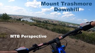
Videos of Mt. Trashmore Mountain Bike

trail: Mt. Trashmore Flow Trail
4:17 |
253 |
Jul 24, 2023 , Cedar Rapids
trail: Mt. Trashmore Flow Trail
3:23 |
240 |
Jul 24, 2023 , Cedar Rapids

trail: Mt. Trashmore Flow Trail
11:38 |
398 |
Oct 20, 2019 , Cedar Rapids
trail: Mt. Trashmore Flow Trail
4:48 |
484 |
Oct 1, 2019 , Cedar Rapids

trail: Mt. Trashmore Flow Trail
2:34 |
438 |
Aug 27, 2018 , Cedar Rapids
Recent Trail Reports
no previous reports, add one now!
Activity Feed
| username | action | type | title | date |
|---|---|---|---|---|
| WillieJacobsz | add | poi | activity #62713561 | Dec 5, 2024 @ 7:31am Dec 5, 2024 |
| RSHites24 | wishlist | trail | activity #61804092 and 1 more | Nov 14, 2024 @ 10:29pm Nov 14, 2024 |
| Spielerin17 | ridden | trail | activity #45725481 | Oct 29, 2023 @ 6:30am Oct 29, 2023 |
| Spielerin17 | ridden | trail | activity #44653379 | Sep 29, 2023 @ 1:21am Sep 29, 2023 |
| mtb-perspective | add | video | activity #42141177 and 1 more | Jul 24, 2023 @ 8:51am Jul 24, 2023 |
Nearby Areas
| name | distance | ||||
|---|---|---|---|---|---|
| Sac & Fox Trail City Park | 5 | 5 | 1 | 2.2 km | |
| Beverly Park | 12 | 12 | 5 | 1 | 3.1 km |
| Seminole Valley Park | 4 | 5 | 1 | 4.9 km | |
| Wanatee Park | 7 | 12 | 5.3 km | ||
| Boyson Park | 3 | 5.6 km |
Activity Type Stats
| activitytype | trails | distance | descent | descent distance | total vertical | rating | global rank | state rank | photos | reports | routes | ridelogs |
|---|---|---|---|---|---|---|---|---|---|---|---|---|
| Mountain Bike | 2 | 1 mile | 203 ft | 2,995 ft | 226 ft | #11,030 | #4,425 | 6 | 16 | 284 | ||
| E-Bike | 1 | 3,658 ft | 203 ft | 2,841 ft | 180 ft | #10,826 | #4,009 | 16 | 5 | |||
| Hike | 2 | 1 mile | 203 ft | 2,995 ft | 226 ft | #21,025 | #10,733 | 12 | 18 | |||
| Trail Running | 2 | 1 mile | 203 ft | 2,995 ft | 226 ft | #19,671 | #9,616 | 12 | 12 |
- By BackyardTrailsLLC
 BackyardTrails & contributors
 - Admins: LAMBA, BackyardTrails, LAMBA
- #24952 - 4,210 views
- mt. trashmore activity log | embed map of Mt. Trashmore mountain bike trails | mt. trashmore mountain biking points of interest
Downloading of trail gps tracks in kml & gpx formats is enabled for Mt. Trashmore.
You must login to download files.