close
-
Layers w
- Weather Layers
- Pro
- Pro
- Pro
- Pro
- Pro
- Pro
- More Layers
- Pro
- Pro
- Pro
- Pro
-
Upgrade to

3D
Trail Conditions
- Unknown
- Snow Groomed
- Snow Packed
- Snow Covered
- Snow Cover Partial
- Freeze/thaw Cycle
- Icy
- Prevalent Mud
- Wet
- Variable
- Ideal
- Dry
- Very Dry
Trail Flow (Ridden Direction)
Trailforks scans users ridelogs to determine the most popular direction each trail is ridden. A good flowing trail network will have most trails flowing in a single direction according to their intension.
The colour categories are based on what percentage of riders are riding a trail in its intended direction.
The colour categories are based on what percentage of riders are riding a trail in its intended direction.
- > 96%
- > 90%
- > 80%
- > 70%
- > 50%
- < 50%
- bi-directional trail
- no data
Trail Last Ridden
Trailforks scans ridelogs to determine the last time a trail was ridden.
- < 2 days
- < 1 week
- < 2 weeks
- < 1 month
- < 6 months
- > 6 months
Trail Ridden Direction
The intended direction a trail should be ridden.
- Downhill Only
- Downhill Primary
- Both Directions
- Uphill Primary
- Uphill Only
- One Direction
Contribute Details
Colors indicate trail is missing specified detail.
- Description
- Photos
- Description & Photos
- Videos
Trail Popularity ?
Trailforks scans ridelogs to determine which trails are ridden the most in the last 9 months.
Trails are compared with nearby trails in the same city region with a possible 25 colour shades.
Think of this as a heatmap, more rides = more kinetic energy = warmer colors.
- most popular
- popular
- less popular
- not popular
ATV/ORV/OHV Filter
Max Vehicle Width
inches
US Cell Coverage
Legend

Radar Time
Activity Recordings
Trailforks uses anonymized public activity data.
?
Activity Recordings
Trailforks uses anonymized public activity data.
?
Personal Heatmap
▶
Activity Types
all
/
none
▶
Options
2
Date range
month
–
Winter Trails
Warning
A routing network for winter maps does not exist. Selecting trails using the winter trails layer has been disabled.
Missing Trails
Most Popular
Least Popular
Trails are colored based on popularity. The more popular a trail is, the more red. Less popular trails trend towards green.
Jump Magnitude Heatmap
Heatmap of where riders jump on trails. Zoom in to see individual jumps, click circles to view jump details.
BC Backroad Status
![map legend]()
Service Road Atlas is a free to use, community-driven service for viewing and creating reports on the numerous back-country service roads around B.C. and Alberta.

Slope Aspect
Direction the slope faces
Trails Deemphasized
Trails are shown in grey.
Only show trails with no bike usage.
Suggested Layers
Based on selected activity type
Save the current map location and zoom level as your default home location whenever this page is loaded.
Save
No description for Mt. Vernon has been added yet!
Login or register to submit one.
Activities Click to view
- Mountain Bike
43 trails
- E-Bike
9 trails
- Gravel Bike
1 trails
- Adaptive Bike
0 trails
- Winter Fat Bike
0 trails
- Hike
39 trails
- Trail Running
39 trails
- Dirtbike/Moto
102 trails
- Observed Trials
97 trails
- ATV/ORV/OHV
87 trails
Region Details
- 13
- 3
- 10
- 16
- 1
Region Status
Open as of Apr 20, 2026Stats
- Avg Trail Rating
- Trails (view details)
- 106
- Trails Mountain Bike
- 44
- Trails E-Bike
- 9
- Trails Gravel Bike
- 1
- Trails Hike
- 39
- Trails Trail Running
- 39
- Trails Dirtbike/Moto
- 102
- Trails Observed Trials
- 97
- Trails ATV/ORV/OHV
- 87
- Trails Snowmobile
- 1
- Total Distance
- 85 miles
- Total Descent
- 7,794 ft
- Total Vertical
- 2,922 ft
- Highest Trailhead
- 2,944 ft
- Reports
- 695
- Photos
- 95
- Ridden Counter
- 15,043
Sub Regions
-
Little Mountain Park
- 3
- 10
- 16
- 1
Popular Mt. Vernon Mountain Biking Trails
• 80 ★ 4.0 • 2,254 ft • 0 ft • 647 •
Fun descent and good option for your climb route to the top of Little Mountain. Has some tight switchbacks, areas, and a log ride, skinny to play on.
• 90 ★ 4.9 • 1,827 ft • 0 ft • 605 •
This is the diamond among more common gems at Little mountain. For enthusiast-level riders, this is the apogee of purpose built trails at Little Mountain. This is your MUST-RIDE trail! Carefully crafted and built over years of work by...
• 75 ★ 3.0 • 2,106 ft • 118 ft • 523 •
Great way to the top for people who enjoy the climb. Really fun in the downhill direction. A few spots to get the wheels off the ground, but is on a steep hillside with some off camber sections, rock gardens, root drops etc. Care should...
• 60 ★ 0.0 • 1,220 ft • 0 ft • 518 •
Kind of a climb/crossover trail. Best used between Huff-N-Puff and or vice-versa. Also, can be used to quickly get to the topside of Huff-N-Puff.
• 75 ★ 3.5 • 4,977 ft • 85 ft • 508 •
Can be ridden in either direction, though I find it best enjoyed starting from the / /Bonnie & Clyde's Junction. Some tight switchbacks, off camber, roots and rock gardens can make this trail difficult for some riders. It is carved...
• 85 ★ 3.8 • 2,766 ft • 5 ft • 501 •
Flowy fun with potential to get the wheels off the ground in a few spots when ridden in the downhill direction. Haven't climbed it yet, but it doesn't seem like it would be terrible... other than the buzzkill you'd be to any downhill...
• 70 ★ 3.5 • 4,557 ft • 186 ft • 440 •
Is mostly downhill when ridden from the road at either end to where it joins Trail near midpoint. Can be fun when you combine the lower section with or the upper section with . Bail off on to get to the parking area at the bottom.
Mt. Vernon Mountain Bike Routes
4 miles • 874 ft • 6 •
A quick sampler to check out both sides of Little Mt with no backtracking. Includes a little road climbing...
3 miles • 563 ft • 5 • Loop •
Solid little loop with somewhat minimal climbing.
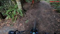
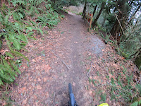
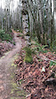
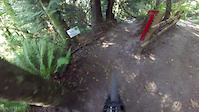
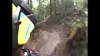
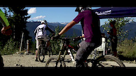
Photos of Mt. Vernon Mountain Bike
Videos of Mt. Vernon Mountain Bike
trail: Pitch-N-Roll
2:17 |
359 |
Mar 18, 2023
trail: Pitch-N-Roll
2:35 |
224 |
Jan 28, 2023
trail: Green Jump Line
0:23 |
119 |
Dec 20, 2021

trail: Pitch-N-Roll
0:09 |
678 |
Nov 29, 2019
trail: Pitch-N-Roll
2:24 |
1038 |
Jul 31, 2019
trail: Pitch-N-Roll
2:37 |
448 |
Apr 8, 2019
trail: Over The Top
0:37 |
105 |
Aug 9, 2015
trail: Rooty
2:55 |
2601 |
Jul 31, 2014
Recent Trail Reports
Activity Feed
| username | action | type | title | date |
|---|---|---|---|---|
| gt1x1 | wishlist | route | activity #96763709 | Jun 11, 2026 @ 3:13pm Jun 11, 2026 |
| bradasshappybottom | wishlist | trail | activity #96522209 | Jun 7, 2026 @ 10:56pm Jun 7, 2026 |
| boxxerace | add | trail | activity #96256733 and 4 more | Jun 4, 2026 @ 3:46pm Jun 4, 2026 |
| boxxerace | update | region | activity #96252548 | Jun 4, 2026 @ 2:34pm Jun 4, 2026 |
| hnconnors | wishlist | route | activity #93534650 | Apr 27, 2026 @ 12:36pm Apr 27, 2026 |
Recent Comments
| username | type | title | comment | date |
|---|---|---|---|---|
| trail | Fun trail, but this in no way even approaches... | Jun 11, 2025 @ 2:24pm Jun 11, 2025 | ||
| trail | There’s a downed tree blocking around... | Dec 11, 2024 @ 11:39pm Dec 11, 2024 | ||
| trail | Tree down has been removed. Thank you so much... | Aug 12, 2024 @ 11:26am Aug 12, 2024 | ||
| trail | I found the climb from the archery club... | Aug 2, 2024 @ 8:47pm Aug 2, 2024 | ||
| trail | There's a tree down over the trail with a... | Jul 10, 2024 @ 11:00pm Jul 10, 2024 |
Local Badges
-

10 Blue Trails207 awarded -

Epic Ride Climb 2k2 awarded -

Climbing 10k Badge26 awarded -

Climbing 100k Badge0 awarded -

Epic Ride Descent 2k3 awarded -

Descent 10k Badge27 awarded
Activity Type Stats
| activitytype | trails | distance | descent | descent distance | total vertical | rating | global rank | state rank | photos | reports | routes | ridelogs |
|---|---|---|---|---|---|---|---|---|---|---|---|---|
| Mountain Bike | 43 | 22 miles | 1,755 ft | 6 miles | 902 ft | #2,343 | #839 | 89 | 692 | 2 | 6,658 | |
| E-Bike | 9 | 6 miles | 167 ft | 2 miles | 135 ft | #7,369 | #2,222 | 556 | 1 | 369 | ||
| Gravel Bike | 1 | #711 | #1,217 | 8 | ||||||||
| Hike | 39 | 17 miles | 1,736 ft | 6 miles | 902 ft | #6,714 | #2,369 | 641 | 1 | 758 | ||
| Trail Running | 39 | 17 miles | 1,736 ft | 6 miles | 902 ft | #6,438 | #2,091 | 641 | 1 | 659 | ||
| Dirtbike/Moto | 102 | 61 miles | 5,404 ft | 19 miles | 2,461 ft | #169 | #102 | 7 | 148 | 1 | 423 | |
| Observed Trials | 97 | 59 miles | 4,537 ft | 17 miles | 2,461 ft | #176 | #29 | 3 | ||||
| ATV/ORV/OHV | 87 | 61 miles | 5,404 ft | 19 miles | 2,461 ft | #396 | #121 | 144 | 20 | |||
| Snowmobile | 1 | 2 miles | 36 ft | 456 ft | 1,152 ft |
Frequently Asked Questions About Mt. Vernon
▼
What are the best places to ride in Mt. Vernon?
Mt. Vernon has 2 areas to explore for mountain biking. The top rated areas are:
▼
What are the highest rated mountain biking trails in Mt. Vernon?
The highest rated mountain biking trails in Mt. Vernon are:
- Pitch-N-Roll (4.7/5)
- Green Flow Dh (4.1/5)
- Mossy Rock (4.1/5)
- Rooty Cutoff (4.1/5)
- Black Jump Line (4.1/5)
▼
What is the best time of the year to ride in Mt. Vernon?
Based on ride log data, the most popular months to ride in Mt. Vernon are:
- July (137 activities)
- June (110 activities)
- September (97 activities)
▼
Where can I park to ride in Mt. Vernon?
There are 11 parking locations listed in Mt. Vernon. The most popular parking spots are: View all parking and trailhead locations on the map to plan your visit.
Activities
Trails
- By jmahler
 TRAILFORKS WMBC Amb & contributors
 - Admins: MVTB, EMBA-C2S
- #13436 - 6,584 views
- mt. vernon activity log | embed map of Mt. Vernon mountain bike trails | mt. vernon mountain biking points of interest
Downloading of trail gps tracks in kml & gpx formats is enabled for Mt. Vernon.
You must login to download files.