close
-
Layers w
- Weather Layers
- Pro
- Pro
- Pro
- Pro
- Pro
- Pro
- More Layers
- Pro
- Pro
- Pro
- Pro
-
Upgrade to

3D
Trail Conditions
- Unknown
- Snow Groomed
- Snow Packed
- Snow Covered
- Snow Cover Partial
- Freeze/thaw Cycle
- Icy
- Prevalent Mud
- Wet
- Variable
- Ideal
- Dry
- Very Dry
Trail Flow (Ridden Direction)
Trailforks scans users ridelogs to determine the most popular direction each trail is ridden. A good flowing trail network will have most trails flowing in a single direction according to their intension.
The colour categories are based on what percentage of riders are riding a trail in its intended direction.
The colour categories are based on what percentage of riders are riding a trail in its intended direction.
- > 96%
- > 90%
- > 80%
- > 70%
- > 50%
- < 50%
- bi-directional trail
- no data
Trail Last Ridden
Trailforks scans ridelogs to determine the last time a trail was ridden.
- < 2 days
- < 1 week
- < 2 weeks
- < 1 month
- < 6 months
- > 6 months
Trail Ridden Direction
The intended direction a trail should be ridden.
- Downhill Only
- Downhill Primary
- Both Directions
- Uphill Primary
- Uphill Only
- One Direction
Contribute Details
Colors indicate trail is missing specified detail.
- Description
- Photos
- Description & Photos
- Videos
Trail Popularity ?
Trailforks scans ridelogs to determine which trails are ridden the most in the last 9 months.
Trails are compared with nearby trails in the same city region with a possible 25 colour shades.
Think of this as a heatmap, more rides = more kinetic energy = warmer colors.
- most popular
- popular
- less popular
- not popular
ATV/ORV/OHV Filter
Max Vehicle Width
inches
US Cell Coverage
Legend

Radar Time
Activity Recordings
Trailforks uses anonymized public activity data.
?
Activity Recordings
Trailforks uses anonymized public activity data.
?
Personal Heatmap
▶
Activity Types
all
/
none
▶
Options
2
Date range
month
–
Winter Trails
Warning
A routing network for winter maps does not exist. Selecting trails using the winter trails layer has been disabled.
Missing Trails
Most Popular
Least Popular
Trails are colored based on popularity. The more popular a trail is, the more red. Less popular trails trend towards green.
Jump Magnitude Heatmap
Heatmap of where riders jump on trails. Zoom in to see individual jumps, click circles to view jump details.
BC Backroad Status
![map legend]()
Service Road Atlas is a free to use, community-driven service for viewing and creating reports on the numerous back-country service roads around B.C. and Alberta.

Slope Aspect
Direction the slope faces
Trails Deemphasized
Trails are shown in grey.
Only show trails with no bike usage.
Suggested Layers
Based on selected activity type
Save the current map location and zoom level as your default home location whenever this page is loaded.
Save
No description for Muenster has been added yet!
Login or register to submit one.
Activities Click to view
- Mountain Bike
1 trails
- E-Bike
0 trails
- Winter Fat Bike
0 trails
- Hike
1 trails
- Trail Running
1 trails
Region Details
- 1
Region Status
Open as of Apr 9, 2026Stats
- Avg Trail Rating
- Trails (view details)
- 1
- Trails Mountain Bike
- 1
- Trails Hike
- 1
- Trails Trail Running
- 1
- Total Distance
- 9 miles
- Total Descent Distance
- 3 miles
- Total Descent
- 803 ft
- Total Vertical
- 241 ft
- Highest Trailhead
- 1,200 ft
- Reports
- 4
- Photos
- 12
- Ridden Counter
- 115
Sub Regions
-
4R Ranch
- 1
Popular Muenster Mountain Biking Trails
• 100 ★ 4.0 • 9 miles • 798 ft • 101 •
The trail encompasses an excellent mix of fast flat stretches with gentle turns, with many fun gravity dips, ravines, short and long climbs, long fast descents and open prairie sections. This can be a very challenging trail if you...
Muenster Mountain Bike Routes
2 miles • 175 ft • 0 •
Just about 2 miles with a little bit of climbing. The Juniors lap is the same as the adults for the first...
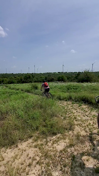
Photos of Muenster Mountain Bike
Videos of Muenster Mountain Bike
0:12 |
564 |
Sep 9, 2020
Recent Trail Reports
| status | trail | date | condition | info | user |
|---|---|---|---|---|---|
| Brambles Mountain Biking Trail | Apr 9, 2026 @ 1:30pm (America/Chicago) Apr 9, 2026 | Variable | SteveAncik3GI |
Activity Feed
| username | action | type | title | date |
|---|---|---|---|---|
| SteveAncik3GI | add | report | activity #92268251 | Apr 9, 2026 @ 11:30am Apr 9, 2026 |
| Samiam132 | wishlist | region | activity #83631957 | Nov 5, 2025 @ 11:48am Nov 5, 2025 |
| werunwild | comment | trail | activity #83198560 | Oct 28, 2025 @ 8:55pm Oct 28, 2025 |
| jglossip | wishlist | trail | activity #74702359 | Jun 27, 2025 @ 8:27pm Jun 27, 2025 |
| jglossip | wishlist | region | activity #74702032 | Jun 27, 2025 @ 8:17pm Jun 27, 2025 |
Recent Comments
| username | type | title | comment | date |
|---|---|---|---|---|
| trail | Fun cross country trail with a few “short... | Oct 28, 2025 @ 8:55pm Oct 28, 2025 | ||
| trail | Fun trail that provides a great workout to... | Mar 19, 2022 @ 2:36pm Mar 19, 2022 |
Activity Type Stats
| activitytype | trails | distance | descent | descent distance | total vertical | rating | global rank | state rank | photos | reports | routes | ridelogs |
|---|---|---|---|---|---|---|---|---|---|---|---|---|
| Mountain Bike | 1 | 9 miles | 804 ft | 3 miles | 243 ft | #6,067 | #2,056 | 12 | 4 | 2 | 890 | |
| Hike | 1 | 9 miles | 804 ft | 3 miles | 243 ft | #12,818 | #4,613 | 4 | 4 | |||
| Trail Running | 1 | 9 miles | 804 ft | 3 miles | 243 ft | #12,313 | #4,312 | 4 | 4 |
- By Duvalj
 & contributors
 - Admins: FWMBA, DORBA MAIN
- #29435 - 1,774 views
- muenster activity log | embed map of Muenster mountain bike trails | muenster mountain biking points of interest
Downloading of trail gps tracks in kml & gpx formats is enabled for Muenster.
You must login to download files.