close
-
Layers w
- Weather Layers
- Pro
- Pro
- Pro
- Pro
- Pro
- Pro
- More Layers
- Pro
- Pro
- Pro
- Pro
-
Upgrade to

3D
Trail Conditions
- Unknown
- Snow Groomed
- Snow Packed
- Snow Covered
- Snow Cover Partial
- Freeze/thaw Cycle
- Icy
- Prevalent Mud
- Wet
- Variable
- Ideal
- Dry
- Very Dry
Trail Flow (Ridden Direction)
Trailforks scans users ridelogs to determine the most popular direction each trail is ridden. A good flowing trail network will have most trails flowing in a single direction according to their intension.
The colour categories are based on what percentage of riders are riding a trail in its intended direction.
The colour categories are based on what percentage of riders are riding a trail in its intended direction.
- > 96%
- > 90%
- > 80%
- > 70%
- > 50%
- < 50%
- bi-directional trail
- no data
Trail Last Ridden
Trailforks scans ridelogs to determine the last time a trail was ridden.
- < 2 days
- < 1 week
- < 2 weeks
- < 1 month
- < 6 months
- > 6 months
Trail Ridden Direction
The intended direction a trail should be ridden.
- Downhill Only
- Downhill Primary
- Both Directions
- Uphill Primary
- Uphill Only
- One Direction
Contribute Details
Colors indicate trail is missing specified detail.
- Description
- Photos
- Description & Photos
- Videos
Trail Popularity ?
Trailforks scans ridelogs to determine which trails are ridden the most in the last 9 months.
Trails are compared with nearby trails in the same city region with a possible 25 colour shades.
Think of this as a heatmap, more rides = more kinetic energy = warmer colors.
- most popular
- popular
- less popular
- not popular
ATV/ORV/OHV Filter
Max Vehicle Width
inches
US Cell Coverage
Legend

Radar Time
Activity Recordings
Trailforks uses anonymized public activity data.
?
Activity Recordings
Trailforks uses anonymized public activity data.
?
Personal Heatmap
▶
Activity Types
all
/
none
▶
Options
2
Date range
month
–
Winter Trails
Warning
A routing network for winter maps does not exist. Selecting trails using the winter trails layer has been disabled.
Missing Trails
Most Popular
Least Popular
Trails are colored based on popularity. The more popular a trail is, the more red. Less popular trails trend towards green.
Jump Magnitude Heatmap
Heatmap of where riders jump on trails. Zoom in to see individual jumps, click circles to view jump details.
BC Backroad Status
![map legend]()
Service Road Atlas is a free to use, community-driven service for viewing and creating reports on the numerous back-country service roads around B.C. and Alberta.

Slope Aspect
Direction the slope faces
Trails Deemphasized
Trails are shown in grey.
Only show trails with no bike usage.
Suggested Layers
Based on selected activity type
Save the current map location and zoom level as your default home location whenever this page is loaded.
Save
No description for Murfreesboro has been added yet!
Login or register to submit one.
Region Supporters & Maintainers
![]()
SORBA Middle TennesseeMaintainer
Activities Click to view
- Mountain Bike
25 trails
- E-Bike
29 trails
- Adaptive Bike
0 trails
- Winter Fat Bike
0 trails
- Hike
36 trails
- Trail Running
36 trails
Region Details
- 2
- 13
- 2
- 4
- 2
Region Status
Open as of Jun 2, 2026Stats
- Avg Trail Rating
- Trails (view details)
- 30
- Trails Mountain Bike
- 25
- Trails E-Bike
- 29
- Trails Hike
- 36
- Trails Trail Running
- 36
- Total Distance
- 33 miles
- Total Descent Distance
- 9 miles
- Total Descent
- 1,453 ft
- Total Vertical
- 314 ft
- Highest Trailhead
- 815 ft
- Reports
- 419
- Photos
- 227
- Ridden Counter
- 1,119
Sub Regions
-
Barfield Crescent Park
- 4
- 2
-
Stone River National Battlefield
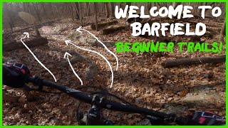
Popular Murfreesboro Mountain Biking Trails
• 90 ★ 3.0 • 1 mile • 73 ft • 97 •
Going in to the right (Counter Clock Wise), the trail starts with a challenging technical climb as you approach the intermediate connector. But from there, the remainder of the route has more downhill. This might be easier for beginners...
• 70 ★ 5.0 • 2 miles • 195 ft • 77 •
Going CW (left) you'll have a few challenging rock slabs to clear on the way up to the top of . You'll have a fun descent with a multiple switchbacks before getting into the Gnar Valley of rock slabs and chunk. This continues to the...
• 90 ★ 5.0 • 1 mile • 102 ft • 75 •
Popular blue difficulty singletrack. This mountain bike primary trail can be used both directions and has a moderate overall physical rating with a 102 ft blue climb. It features rock face and rock garden. On average it takes 24 minutes to complete this trail.
• 100 ★ 4.0 • 3,369 ft • 29 ft • 62 •
Popular blue difficulty singletrack. This mountain bike primary trail can be used both directions and has a moderate overall physical rating with a 29 ft green climb. Trail visibility is always easy to follow. On average it takes 6 minutes to complete this trail.
• 85 ★ 3.0 • 1 mile • 132 ft • 59 •
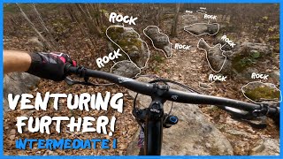
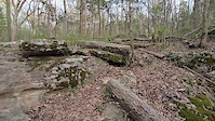
Technically challenging trail with several large rocks to maneuver. The straight sections are not as difficult but are still on a mostly rocky surface.
• 75 ★ 5.0 • 3,661 ft • 77 ft • 54 •
is likely one of the tougher trails at Barfield. CCW (go in to the right) is a little easier for most of the trail but then ends with a long climb through a rock garden. Starting in a CW direction begins with an easier decent through...
• 80 ★ 5.0 • 11 miles • 178 ft • 26 •
The Stones River Trail is the backbone of the Murfreesboro Greenway System. It follows the West Fork Stones River for 10.5 miles from Thompson Lane Trailhead to Barfield Crescent Park Trailhead. The meandering asphalt trail winds...
Murfreesboro Mountain Bike Routes
2 miles • 147 ft • 3 • Loop •
Parking lot to and back. Pick your direction based on day or choice. Left (CW) tends to be a bit easier.
4 miles • 361 ft • 6 • Out & Back •
Shortest route to ride . This section IS the quicker & easier way out and back. It may be "backwards"...
4 miles • 417 ft • 4 • Loop •
Recommended route for riding just the advanced trails. is less technical going CW (going down rocks...
8 miles • 679 ft • 11 • Loop •
Clockwise route of the entire trail system. CW is the intended direction for: Monday, Wednesday, Friday...
3 miles • 108 ft • 1 • Out & Back •
This multiuse loop starts at the Central Valley trailhead and is just the extension that opened in early...
5 miles • 341 ft • 3 • Out & Back •
This multiuse loop starts at the Walter Hill trailhead and includes the extension that opened in early...
Photos of Murfreesboro Mountain Bike
Videos of Murfreesboro Mountain Bike
featured
![Barfield Intermediate 1 - Trail Ride or ASMR?]()
trail: Thunderlips
25:04 |
483 |
Apr 5, 2022 , Murfreesboro
trail: Marshall Knobs Trail
0:27 |
14 |
Mar 30, 2025
trail: Marshall Knobs Trail
0:27 |
5 |
Mar 30, 2025
trail: Marshall Knobs Trail
0:23 |
4 |
Mar 30, 2025
trail: Marshall Knobs Trail
0:21 |
5 |
Mar 30, 2025
trail: Marshall Knobs Trail
0:23 |
3 |
Mar 30, 2025
trail: Marshall Knobs Trail
0:43 |
4 |
Mar 30, 2025
Recent Trail Reports
| status | trail | date | condition | info | user |
|---|---|---|---|---|---|
| Mickey | Jun 2, 2026 @ 2:13pm (America/Chicago) Jun 2, 2026 | Variable | hillmakeitbetter SORBAMIDTN | ||
| Thunderlips | Apr 26, 2026 @ 5:54pm (America/Chicago) Apr 26, 2026 | Ideal | ajmtbtn Barfield | ||
| Drago | Apr 21, 2026 @ 6:23pm (America/Chicago) Apr 21, 2026 | Unknown | ajmtbtn Barfield | ||
| Apollo | Apr 21, 2026 @ 11:47am (America/Chicago) Apr 21, 2026 | Unknown | MatthewuA2Bkt SORBAMIDTN | ||
| Clubber Lang | Apr 21, 2026 @ 11:30am (America/Chicago) Apr 21, 2026 | Unknown | MatthewuA2Bkt SORBAMIDTN | ||
| Yo Adrian | Mar 26, 2026 @ 7:22am (America/Chicago) Mar 26, 2026 | Ideal | hillmakeitbetter SORBAMIDTN | ||
| Paulie | Feb 6, 2026 @ 8:46pm (America/Chicago) Feb 6, 2026 | Variable | ajmtbtn Barfield | ||
| Barfield MTB Trail | Feb 6, 2026 @ 8:46pm (America/Chicago) Feb 6, 2026 | Variable | ajmtbtn Barfield | ||
| Barfield Connector: Mickey - Paulie | Feb 6, 2026 @ 8:46pm (America/Chicago) Feb 6, 2026 | Variable | ajmtbtn Barfield | ||
| MTB Trailhead Parking | Sep 18, 2025 @ 7:09pm (America/Chicago) Sep 18, 2025 | Ideal | ajmtbtn Barfield |
Activity Feed
| username | action | type | title | date |
|---|---|---|---|---|
| hillmakeitbetter | add | report | activity #96101967 | Jun 2, 2026 @ 12:14pm Jun 2, 2026 |
| ajmtbtn | add | report | activity #95849408 | May 30, 2026 @ 7:23am May 30, 2026 |
| PScud | wishlist | region | activity #95798514 | May 29, 2026 @ 1:20pm May 29, 2026 |
| falcon013 | add | report | activity #95611869 and 2 more | May 26, 2026 @ 8:55pm May 26, 2026 |
| ajmtbtn | add | report | activity #93485147 | Apr 26, 2026 @ 3:54pm Apr 26, 2026 |
Recent Comments
| username | type | title | comment | date |
|---|---|---|---|---|
| report | Updating issue status to Open | Mar 20, 2025 @ 11:25am Mar 20, 2025 | ||
| report | Updating issue status to Open | Mar 20, 2025 @ 11:24am Mar 20, 2025 | ||
| report | Updating issue status to Open | Mar 20, 2025 @ 11:24am Mar 20, 2025 | ||
| report | Updating issue status to Open | Mar 20, 2025 @ 11:23am Mar 20, 2025 | ||
| report | Updating issue status to Open | Mar 20, 2025 @ 11:22am Mar 20, 2025 |
Local Badges
-

Epic Mountain Bike Climb 2k0 awarded -

Climbing 10k Badge3 awarded -

Mountain Biking 100k Badge0 awarded -

Epic Ride Descent 2k0 awarded -

Descent 10k Badge3 awarded -

Descent 100k Badge0 awarded
Bike & Skill Parks
| name | type | city | rating |
|---|---|---|---|
| Christiana MX | skill park | Murfreesboro | |
| Old Fort Park Skate Park | skill park | Murfreesboro |
Activity Type Stats
| activitytype | trails | distance | descent | descent distance | total vertical | rating | global rank | state rank | photos | reports | routes | ridelogs |
|---|---|---|---|---|---|---|---|---|---|---|---|---|
| Mountain Bike | 25 | 27 miles | 951 ft | 7 miles | 315 ft | #4,552 | #1,530 | 165 | 415 | 7 | 2,805 | |
| E-Bike | 29 | 32 miles | 1,447 ft | 9 miles | 315 ft | #3,708 | #1,268 | 393 | 7 | 45 | ||
| Hike | 36 | 26 miles | 955 ft | 7 miles | 312 ft | #3,376 | #1,186 | 64 | 223 | 3 | 118 | |
| Trail Running | 36 | 26 miles | 955 ft | 7 miles | 312 ft | #5,573 | #1,766 | 222 | 3 | 81 |
Frequently Asked Questions About Murfreesboro
▼
What are the best places to ride in Murfreesboro?
Murfreesboro has 2 areas to explore for mountain biking. The top rated areas are:
▼
What are the highest rated mountain biking trails in Murfreesboro?
The highest rated mountain biking trails in Murfreesboro are:
- Thunderlips (4.2/5)
- Stones River Trail (4.1/5)
- Drago (4.1/5)
- Apollo (4.1/5)
- Yo Adrian (4/5)
▼
What is the best time of the year to ride in Murfreesboro?
Based on ride log data, the most popular months to ride in Murfreesboro are:
- July (16 activities)
- May (13 activities)
- October (12 activities)
▼
Where can I park to ride in Murfreesboro?
There are 9 parking locations listed in Murfreesboro. The most popular parking spots are: View all parking and trailhead locations on the map to plan your visit.
Activities
Trails
Points of Interest
- By brenthillier
 NSMBA TRAILFORKS & contributors
 - Admins: SORBAMIDTN, trail13tl
- #20762 - 3,503 views
- murfreesboro activity log | embed map of Murfreesboro mountain bike trails | murfreesboro mountain biking points of interest
Downloading of trail gps tracks in kml & gpx formats is enabled for Murfreesboro.
You must login to download files.