close
-
Layers w
- Weather Layers
- Pro
- Pro
- Pro
- Pro
- Pro
- Pro
- More Layers
- Pro
- Pro
- Pro
- Pro
-
Upgrade to

3D
Trail Conditions
- Unknown
- Snow Groomed
- Snow Packed
- Snow Covered
- Snow Cover Partial
- Freeze/thaw Cycle
- Icy
- Prevalent Mud
- Wet
- Variable
- Ideal
- Dry
- Very Dry
Trail Flow (Ridden Direction)
Trailforks scans users ridelogs to determine the most popular direction each trail is ridden. A good flowing trail network will have most trails flowing in a single direction according to their intension.
The colour categories are based on what percentage of riders are riding a trail in its intended direction.
The colour categories are based on what percentage of riders are riding a trail in its intended direction.
- > 96%
- > 90%
- > 80%
- > 70%
- > 50%
- < 50%
- bi-directional trail
- no data
Trail Last Ridden
Trailforks scans ridelogs to determine the last time a trail was ridden.
- < 2 days
- < 1 week
- < 2 weeks
- < 1 month
- < 6 months
- > 6 months
Trail Ridden Direction
The intended direction a trail should be ridden.
- Downhill Only
- Downhill Primary
- Both Directions
- Uphill Primary
- Uphill Only
- One Direction
Contribute Details
Colors indicate trail is missing specified detail.
- Description
- Photos
- Description & Photos
- Videos
Trail Popularity ?
Trailforks scans ridelogs to determine which trails are ridden the most in the last 9 months.
Trails are compared with nearby trails in the same city region with a possible 25 colour shades.
Think of this as a heatmap, more rides = more kinetic energy = warmer colors.
- most popular
- popular
- less popular
- not popular
ATV/ORV/OHV Filter
Max Vehicle Width
inches
US Cell Coverage
Legend

Radar Time
Activity Recordings
Trailforks uses anonymized public activity data.
?
Activity Recordings
Trailforks uses anonymized public activity data.
?
Personal Heatmap
▶
Activity Types
all
/
none
▶
Options
2
Date range
month
–
Winter Trails
Warning
A routing network for winter maps does not exist. Selecting trails using the winter trails layer has been disabled.
Missing Trails
Most Popular
Least Popular
Trails are colored based on popularity. The more popular a trail is, the more red. Less popular trails trend towards green.
Jump Magnitude Heatmap
Heatmap of where riders jump on trails. Zoom in to see individual jumps, click circles to view jump details.
BC Backroad Status
![map legend]()
Service Road Atlas is a free to use, community-driven service for viewing and creating reports on the numerous back-country service roads around B.C. and Alberta.

Slope Aspect
Direction the slope faces
Trails Deemphasized
Trails are shown in grey.
Only show trails with no bike usage.
Suggested Layers
Based on selected activity type
Save the current map location and zoom level as your default home location whenever this page is loaded.
Save
No description for Murrieta has been added yet!
Login or register to submit one.
Activities Click to view
- Mountain Bike
217 trails
- E-Bike
165 trails
- Adaptive Bike
3 trails
- Winter Fat Bike
0 trails
- Horse
8 trails
- Hike
208 trails
- Trail Running
203 trails
Region Details
- 10
- 1
- 56
- 76
- 38
- 5
Region Status
Caution as of Jun 13, 2026Stats
- Avg Trail Rating
- Trails (view details)
- 203
- Trails Mountain Bike
- 218
- Trails E-Bike
- 165
- Trails Gravel Bike
- 5
- Trails Adaptive Bike
- 3
- Trails Horse
- 8
- Trails Hike
- 208
- Trails Trail Running
- 203
- Trails Dirtbike/Moto
- 3
- Trails Observed Trials
- 1
- Trails ATV/ORV/OHV
- 1
- Total Distance
- 78 miles
- Total Descent
- 14,143 ft
- Total Vertical
- 1,081 ft
- Highest Trailhead
- 2,120 ft
- Reports
- 641
- Photos
- 289
- Ridden Counter
- 30,345
Sub Regions
-
951 Trails
- 1
- 10
- 3
-
Greer Ranch
- 41
- 53
- 30
- 5
-
Hogbacks
- 2
- 4
-
Rancho Bella Vista
- 1
- 9
- 5
-
Santa Rosa Plateau Ecological Reserve
-
The Plateau
- 10
- 1
Popular Murrieta Mountain Biking Trails
• 100 ★ 4.2 • 3,120 ft • 16 ft • 1,276 •
Highly rated popular black diamond difficulty singletrack. This mountain bike primary trail and has a moderate overall physical rating with a 16 ft black diamond climb. It features a-frame, berm, drop, jump, rock face, rock garden and roller coaster. Trail visibility is always easy to follow. On average it takes 9 minutes to complete this trail.
• 100 ★ 4.9 • 4,291 ft • 7 ft • 1,214 •
Highly rated popular black diamond difficulty singletrack. This mountain bike primary trail can be used downhill primary and has a moderate overall physical rating with a 7 ft black diamond climb. It features a-frame, berm, drop, jump, rock face, rock garden and roller coaster. Trail visibility is always easy to follow. On average it takes 9 minutes to complete this trail.
• 100 ★ 4.3 • 1 mile • 249 ft • 1,146 •
The to get to and from most of the trails in this area.
• 95 ★ 4.9 • 3,350 ft • 0 ft • 1,079 •
Highly rated popular black diamond difficulty singletrack. This mountain bike primary trail and has a moderate overall physical rating with a 0 ft black diamond climb. It features a-frame, berm, jump, rock garden and roller coaster. Trail visibility is always easy to follow. On average it takes 4 minutes to complete this trail.
• 95 ★ 4.5 • 3,806 ft • 3 ft • 927 •
Great high-speed, if you want, flow trail that offers great jumps, gap jumps, berms. Lower section perfect for sessioning and practicing jumping. Different gap lengths that let you progress as your skills grow
• 100 ★ 4.3 • 2,362 ft • 142 ft • 848 •
This trail is primarily for climbing back to the top of Overdrive, Rabbit Hole, and Distortion. This climb is very forgiving and has a flow of a climb.
• 90 ★ 4.0 • 925 ft • 33 ft • 826 •
Popular green difficulty singletrack. This mountain bike primary trail and has a easy overall physical rating with a 33 ft green climb. It features berm. Trail visibility is always easy to follow. On average it takes 1 minutes to complete this trail.
Murrieta Mountain Bike Routes
7 miles • 961 ft • 14 • Loop •
blue greer ranch loop, starts at greer ranch trailhead
Photos of Murrieta Mountain Bike
Videos of Murrieta Mountain Bike

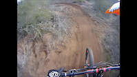
trail: Jumping Mouse
0:17 |
167 |
Oct 19, 2023
trail: Jumping Mouse
0:17 |
|
Oct 18, 2023

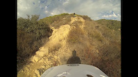
trail: Distortion Upper
3:00 |
91 |
Mar 18, 2022
trail: Distortion Lower
0:41 |
|
Aug 15, 2021
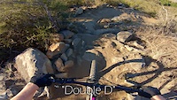
trail: Double D
0:19 |
335 |
Feb 13, 2021
trail: Shivela
11:34 |
79 |
Dec 27, 2019
trail: Double D
2:19 |
172 |
Jan 18, 2016
trail: Double D
3:26 |
436 |
Aug 23, 2014
Current Trail Warnings
| status | trail | date | condition | user | info |
|---|---|---|---|---|---|
| Dog Town | Jun 13, 2026 @ 10:26am (America/Los_Angeles) Jun 13, 2026 | Dry | socalmtbguide | Looks to be a big downed tree blocking... |
Recent Trail Reports
| status | trail | date | condition | info | user |
|---|---|---|---|---|---|
| Trail X | May 23, 2026 @ 1:59pm (America/Los_Angeles) May 23, 2026 | Variable | bjdrums | ||
| Rocket Bike Trail | Apr 8, 2026 @ 7:56pm (America/Los_Angeles) Apr 8, 2026 | Unknown | Jbeykirch | ||
| 215 Trail | Mar 13, 2026 @ 4:04pm (America/Los_Angeles) Mar 13, 2026 | Very Dry | ErikGiant | ||
| Double D | Feb 23, 2026 @ 12:06pm (America/Los_Angeles) Feb 23, 2026 | Ideal | jabronipwni | ||
| Toll Road | Feb 22, 2026 @ 7:06am (America/Los_Angeles) Feb 22, 2026 | Variable | jatank | ||
| Lower Rabbit Hole | Feb 23, 2026 @ 6:35am (America/Los_Angeles) Feb 23, 2026 | Ideal | jabronipwni | ||
| OTX Southbound | Feb 15, 2026 @ 9:37pm (America/Los_Angeles) Feb 15, 2026 | Unknown | jkovaly | ||
| Hard Start | Feb 13, 2026 @ 7:45pm (America/Los_Angeles) Feb 13, 2026 | Variable | tbtel Alpine | ||
| Top-Down | Feb 13, 2026 @ 7:45pm (America/Los_Angeles) Feb 13, 2026 | Variable | tbtel Alpine | ||
| Turn Down | Feb 13, 2026 @ 7:45pm (America/Los_Angeles) Feb 13, 2026 | Variable | tbtel Alpine |
Activity Feed
| username | action | type | title | date |
|---|---|---|---|---|
| mforton | wishlist | route | activity #97249013 | Jun 18, 2026 @ 6:56am 2 days |
| SharonHBv4lf | wishlist | trail | activity #97113119 | Jun 16, 2026 @ 8:37am Jun 16, 2026 |
| socalmtbguide | add | report | activity #97025588 | Jun 14, 2026 @ 11:50pm Jun 14, 2026 |
| socalmtbguide | difficultyvote | trail | activity #97025161 and 1 more | Jun 14, 2026 @ 11:32pm Jun 14, 2026 |
| Nassau | wishlist | region | activity #96699777 | Jun 10, 2026 @ 3:40pm Jun 10, 2026 |
Recent Comments
| username | type | title | comment | date |
|---|---|---|---|---|
| trail | Blue climbing trail. Not for beginners | Mar 14, 2026 @ 1:48pm Mar 14, 2026 | ||
| trail | Has large jumps with ride arounds. Good option... | Feb 13, 2026 @ 7:54pm Feb 13, 2026 | ||
| trail | Service road, not a trail | Feb 13, 2026 @ 7:48pm Feb 13, 2026 | ||
| trail | This "trail" starts on a pile of rocks with no... | Feb 13, 2026 @ 7:40pm Feb 13, 2026 | ||
| trail | Service road. Not a trail | Feb 13, 2026 @ 7:23pm Feb 13, 2026 |
Local Badges
-

10 Blue Trails285 awarded -

Epic Ride 50k1,197 awarded -

Top 10 Trails2 awarded -

Completionist2 awarded -

Big Ride 30k2,945 awarded -
Completionist1 awarded
Local Trail Supporters
- Builder is on youtube
Activity Type Stats
| activitytype | trails | distance | descent | descent distance | total vertical | rating | global rank | state rank | photos | reports | routes | ridelogs |
|---|---|---|---|---|---|---|---|---|---|---|---|---|
| Mountain Bike | 217 | 59 miles | 11,322 ft | 27 miles | 1,083 ft | #613 | #228 | 303 | 640 | 2 | 36,507 | |
| E-Bike | 165 | 20 miles | 4,291 ft | 9 miles | 974 ft | #1,057 | #807 | 3 | 535 | 5,562 | ||
| Gravel Bike | 5 | #1,397 | #741 | 1 | 72 | |||||||
| Adaptive Bike | 3 | #619 | #1,892 | |||||||||
| Horse | 8 | 5 miles | 377 ft | 1 mile | 259 ft | #2,253 | #1,246 | 81 | 4 | |||
| Hike | 208 | 69 miles | 11,329 ft | 30 miles | 1,083 ft | #918 | #419 | 5 | 617 | 924 | ||
| Trail Running | 203 | 66 miles | 10,738 ft | 28 miles | 1,083 ft | #2,156 | #684 | 617 | 217 | |||
| Dirtbike/Moto | 3 | 79 | 20 | |||||||||
| Observed Trials | 1 | 2 | ||||||||||
| ATV/ORV/OHV | 1 | 79 | 2 |
Frequently Asked Questions About Murrieta
▼
What are the best places to ride in Murrieta?
Murrieta has 7 areas to explore for mountain biking. The top rated areas are:
▼
What are the highest rated mountain biking trails in Murrieta?
The highest rated mountain biking trails in Murrieta are:
- Overdrive Top (4.6/5)
- Distortion Lower (4.4/5)
- Double D (4.4/5)
- Monk Dawg (4.3/5)
- Jumping Mouse (4.2/5)
▼
What is the best time of the year to ride in Murrieta?
Based on ride log data, the most popular months to ride in Murrieta are:
- July (162 activities)
- May (145 activities)
- June (135 activities)
▼
Where can I park to ride in Murrieta?
There are 7 parking locations listed in Murrieta. The most popular parking spots are: View all parking and trailhead locations on the map to plan your visit.
Activities
Trails
- By hsracer
 & contributors
 - Admins: IVMTB
- #20620 - 10,528 views
- murrieta activity log | embed map of Murrieta mountain bike trails | murrieta mountain biking points of interest
Downloading of trail gps tracks in kml & gpx formats is enabled for Murrieta.
You must login to download files.