close
-
Layers w
- Weather Layers
- Pro
- Pro
- Pro
- Pro
- Pro
- Pro
- More Layers
- Pro
- Pro
- Pro
- Pro
-
Upgrade to

3D
Trail Conditions
- Unknown
- Snow Groomed
- Snow Packed
- Snow Covered
- Snow Cover Partial
- Freeze/thaw Cycle
- Icy
- Prevalent Mud
- Wet
- Variable
- Ideal
- Dry
- Very Dry
Trail Flow (Ridden Direction)
Trailforks scans users ridelogs to determine the most popular direction each trail is ridden. A good flowing trail network will have most trails flowing in a single direction according to their intension.
The colour categories are based on what percentage of riders are riding a trail in its intended direction.
The colour categories are based on what percentage of riders are riding a trail in its intended direction.
- > 96%
- > 90%
- > 80%
- > 70%
- > 50%
- < 50%
- bi-directional trail
- no data
Trail Last Ridden
Trailforks scans ridelogs to determine the last time a trail was ridden.
- < 2 days
- < 1 week
- < 2 weeks
- < 1 month
- < 6 months
- > 6 months
Trail Ridden Direction
The intended direction a trail should be ridden.
- Downhill Only
- Downhill Primary
- Both Directions
- Uphill Primary
- Uphill Only
- One Direction
Contribute Details
Colors indicate trail is missing specified detail.
- Description
- Photos
- Description & Photos
- Videos
Trail Popularity ?
Trailforks scans ridelogs to determine which trails are ridden the most in the last 9 months.
Trails are compared with nearby trails in the same city region with a possible 25 colour shades.
Think of this as a heatmap, more rides = more kinetic energy = warmer colors.
- most popular
- popular
- less popular
- not popular
ATV/ORV/OHV Filter
Max Vehicle Width
inches
US Cell Coverage
Legend

Radar Time
Activity Recordings
Trailforks uses anonymized public activity data.
?
Activity Recordings
Trailforks uses anonymized public activity data.
?
Personal Heatmap
▶
Activity Types
all
/
none
▶
Options
2
Date range
month
–
Winter Trails
Warning
A routing network for winter maps does not exist. Selecting trails using the winter trails layer has been disabled.
Missing Trails
Most Popular
Least Popular
Trails are colored based on popularity. The more popular a trail is, the more red. Less popular trails trend towards green.
Jump Magnitude Heatmap
Heatmap of where riders jump on trails. Zoom in to see individual jumps, click circles to view jump details.
BC Backroad Status
![map legend]()
Service Road Atlas is a free to use, community-driven service for viewing and creating reports on the numerous back-country service roads around B.C. and Alberta.

Slope Aspect
Direction the slope faces
Trails Deemphasized
Trails are shown in grey.
Only show trails with no bike usage.
Suggested Layers
Based on selected activity type
Save the current map location and zoom level as your default home location whenever this page is loaded.
Save
No description for Nakusp has been added yet!
Login or register to submit one.
Activities Click to view
- Mountain Bike
85 trails
- E-Bike
44 trails
- Gravel Bike
0 trails
- Adaptive Bike
0 trails
- Horse
5 trails
- Hike
117 trails
- Trail Running
117 trails
- Dirtbike/Moto
4 trails
- ATV/ORV/OHV
4 trails
Region Details
- 11
- 2
- 11
- 28
- 22
- 5
Region Status
Caution as of 2 daysStats
- Avg Trail Rating
- Trails (view details)
- 81
- Trails Mountain Bike
- 118
- Trails E-Bike
- 44
- Trails Horse
- 5
- Trails Hike
- 117
- Trails Trail Running
- 117
- Trails Dirtbike/Moto
- 4
- Trails Observed Trials
- 2
- Trails ATV/ORV/OHV
- 4
- Trails Snowshoe
- 2
- Total Distance
- 90 miles
- Total Descent
- 21,723 ft
- Total Vertical
- 6,048 ft
- Highest Trailhead
- 7,500 ft
- Reports
- 1,256
- Photos
- 235
- Ridden Counter
- 49,647
Articles

Video: Trail Building in British Columbia's Kootenay Mountains
May 15, 2022 from pinkbike.com
A series of short films featuring the work done by trail builders in the Kootenay region of British Columbia.
Sub Regions
-
Box Lake
- 1
- 1
- 3
- 3
-
Mt. Abriel
- 8
- 27
- 16
- 5
Popular Nakusp Mountain Biking Trails
• 100 ★ 4.2 • 2 miles • 550 ft • 1,755 •
Highly rated popular blue difficulty singletrack. This mountain bike primary trail can be used uphill primary. It features bridge. On average it takes 7 minutes to complete this trail.
• 100 ★ 3.7 • 1 mile • 670 ft • 1,220 •
Popular blue difficulty singletrack. This mountain bike primary trail can be used uphill primary. On average it takes 17 minutes to complete this trail.
• 95 ★ 4.0 • 2,100 ft • 15 ft • 1,086 •
Popular blue difficulty singletrack. This mountain bike primary trail can be used downhill only. It features berm and jump. On average it takes 3 minutes to complete this trail.
• 95 ★ 3.7 • 1 mile • 25 ft • 1,038 •
Popular blue difficulty doubletrack. This mountain bike primary trail can be used downhill only. On average it takes 11 minutes to complete this trail.
• 90 ★ 4.2 • 3,720 ft • 17 ft • 999 •
Popular green difficulty family friendly singletrack. This mountain bike primary trail and has a moderate overall physical rating. It features berm. On average it takes 3 minutes to complete this trail.
• 95 ★ 3.0 • 4,475 ft • 254 ft • 971 •
Popular blue difficulty singletrack. This mountain bike primary trail can be used uphill primary. On average it takes 12 minutes to complete this trail.
Nakusp Mountain Bike Routes
★ 3.7 • 2 miles • 507 ft • 5 • Out & Back •
This route is used by those renting for the first time at Kootenay Adaptive, or adaptive riders just...
★ 4.0 • 14 miles • 4,693 ft • 21 •
Abriel Epic Loop - From Campground to the top and back.
★ 2.0 • 6 miles • 1,057 ft • 8 • Loop •
A moderate pedal with a few descents. - If you don't like the route take it up with Brent at the bike shop.
17 miles • 5,139 ft • 14 • Race •
Final stage of Singletrack 6 in 2024. Full pint.
11 miles • 2,907 ft • 8 • Race •
Half pint final stage of the Singletrack 6 event in 2024.
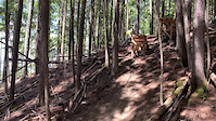
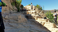
Photos of Nakusp Mountain Bike
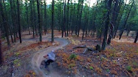
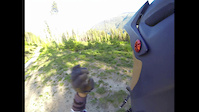
Videos of Nakusp Mountain Bike
trail: Loamly Lion
0:05 |
1014 |
Jul 13, 2022
trail: Ride On
0:40 |
574 |
Sep 29, 2016
trail: Horse Thief
0:11 |
1634 |
Jul 12, 2016
trail: Ride On
2:54 |
286 |
May 7, 2016

trail: Ride On
0:24 |
642 |
Aug 2, 2014
trail: Ride On
4:57 |
243 |
Mar 27, 2014

trail: Ride On
0:44 |
369 |
Jan 22, 2014

trail: Ride On
6:03 |
163 |
Oct 5, 2013
Recent Trail Reports
| status | trail | date | condition | info | user |
|---|---|---|---|---|---|
| Black and Blue | Jun 29, 2026 @ 8:06am (America/Vancouver) 2 days | Dry | mikestewart | ||
| Tropic Thunder | Jun 29, 2026 @ 8:05am (America/Vancouver) 2 days | Ideal | mikestewart | ||
| Dazed | Jun 29, 2026 @ 8:05am (America/Vancouver) 2 days | Ideal | mikestewart | ||
| Block Party | Jun 29, 2026 @ 8:04am (America/Vancouver) 2 days | Variable | mikestewart | ||
| Upper Rolaids | Jun 29, 2026 @ 8:02am (America/Vancouver) 2 days | Ideal | mikestewart | ||
| Upper Dusty Panther | Jun 29, 2026 @ 8:02am (America/Vancouver) 2 days | Dry | mikestewart | ||
| Minty Fresh | Jun 29, 2026 @ 8:01am (America/Vancouver) 2 days | Ideal | mikestewart | ||
| Ride On | Jun 23, 2026 @ 7:51pm (America/Vancouver) Jun 23, 2026 | Unknown | litespeed74 | ||
| Hot Springs Trail | Jun 19, 2026 @ 7:52am (America/Creston) Jun 19, 2026 | Ideal | Jaydee60 | ||
| Hollywood Hills | Jun 11, 2026 @ 8:26pm (America/Creston) Jun 11, 2026 | Ideal | Groat07 |
Activity Feed
| username | action | type | title | date |
|---|---|---|---|---|
| tranc2 | vote | route | activity #98162817 | Jun 30, 2026 @ 4:25pm 14 hours |
| hoopaslotche | wishlist | region | activity #98098352 | Jun 29, 2026 @ 5:43pm 2 days |
| mikestewart | add | report | activity #98063962 and 6 more | Jun 29, 2026 @ 8:01am 2 days |
| mikestewart | ridden | trail | activity #98063905 and 9 more | Jun 29, 2026 @ 8:00am 2 days |
| BCrider72 | vote | trail | activity #98037530 | Jun 28, 2026 @ 5:57pm 2 days |
Recent Comments
| username | type | title | comment | date |
|---|---|---|---|---|
| trail | Nice rolling trail. Easier than Rollie Pollie,... | Oct 6, 2025 @ 8:00am Oct 6, 2025 | ||
| trail | Tropic Thunder is pretty punched out. Loose... | Aug 28, 2025 @ 7:18pm Aug 28, 2025 | ||
| trail | Trail is very steep in loose in places and is... | Aug 7, 2025 @ 7:38pm Aug 7, 2025 | ||
| trail | Techy goodness with some fun scenic features | Jul 27, 2025 @ 1:58pm Jul 27, 2025 | ||
| trail | So fun! Light black. | Jul 27, 2025 @ 1:40pm Jul 27, 2025 |
Local Badges
-

10 Blue Trails903 awarded -

Epic Ride Climb 2k79 awarded -

Climbing 10k Badge34 awarded -

Climbing 100k Badge1 awarded -

Epic Ride Descent 2k103 awarded -

Descent 10k Badge49 awarded
Bike & Skill Parks
| name | type | city | rating |
|---|---|---|---|
| Mount Abriel Skillpark | skill park | Nakusp |
Local Trail Supporters
- Kootenay Sufferfest
![]()
Activity Type Stats
| activitytype | trails | distance | descent | descent distance | total vertical | rating | global rank | state rank | photos | reports | routes | ridelogs |
|---|---|---|---|---|---|---|---|---|---|---|---|---|
| Mountain Bike | 85 | 83 miles | 20,679 ft | 35 miles | 4,373 ft | #768 | #45 | 237 | 1,339 | 6 | 11,957 | |
| E-Bike | 44 | 30 miles | 4,255 ft | 8 miles | 4,373 ft | #2,800 | #72 | 1,088 | 612 | |||
| Horse | 5 | 18 miles | 407 ft | 2 miles | 4,275 ft | #1,267 | #45 | 247 | ||||
| Hike | 117 | 89 miles | 20,522 ft | 35 miles | 6,050 ft | #1,963 | #78 | 5 | 1,319 | 732 | ||
| Trail Running | 117 | 89 miles | 20,522 ft | 35 miles | 6,050 ft | #1,552 | #55 | 1,319 | 161 | |||
| Dirtbike/Moto | 4 | 17 miles | 407 ft | 1 mile | 4,072 ft | #701 | #52 | 245 | 11 | |||
| Observed Trials | 2 | 9 miles | 400 ft | 1 mile | 4,072 ft | 5 | 2 | |||||
| ATV/ORV/OHV | 4 | 17 miles | 407 ft | 1 mile | 4,072 ft | #504 | #38 | 245 | 8 | |||
| Snowshoe | 2 | 8 miles | 1,375 ft | 2 miles | 1,985 ft | 99 |
Frequently Asked Questions About Nakusp
▼
What are the best places to ride in Nakusp?
Nakusp has 2 areas to explore for mountain biking. The top rated areas are:
▼
What are the highest rated mountain biking trails in Nakusp?
The highest rated mountain biking trails in Nakusp are:
- Hollywood Hills (4.5/5)
- Zoolander (4.4/5)
- The Lovenest Connection (4.3/5)
- Something Flumey (4.3/5)
- PEPÈ (4.3/5)
▼
What is the best time of the year to ride in Nakusp?
Based on ride log data, the most popular months to ride in Nakusp are:
- July (296 activities)
- August (242 activities)
- June (188 activities)
▼
Where can I park to ride in Nakusp?
Activities
Trails
- By barry-mclane & contributors
- Admins: barry-mclane, KCTS, NABS
- #5747 - 28,948 views
- nakusp activity log | embed map of Nakusp mountain bike trails | nakusp mountain biking points of interest
Downloading of trail gps tracks in kml & gpx formats is enabled for Nakusp.
You must login to download files.