close
-
Layers w
- Weather Layers
- Pro
- Pro
- Pro
- Pro
- Pro
- Pro
- More Layers
- Pro
- Pro
- Pro
- Pro
-
Upgrade to

3D
Trail Conditions
- Unknown
- Snow Groomed
- Snow Packed
- Snow Covered
- Snow Cover Partial
- Freeze/thaw Cycle
- Icy
- Prevalent Mud
- Wet
- Variable
- Ideal
- Dry
- Very Dry
Trail Flow (Ridden Direction)
Trailforks scans users ridelogs to determine the most popular direction each trail is ridden. A good flowing trail network will have most trails flowing in a single direction according to their intension.
The colour categories are based on what percentage of riders are riding a trail in its intended direction.
The colour categories are based on what percentage of riders are riding a trail in its intended direction.
- > 96%
- > 90%
- > 80%
- > 70%
- > 50%
- < 50%
- bi-directional trail
- no data
Trail Last Ridden
Trailforks scans ridelogs to determine the last time a trail was ridden.
- < 2 days
- < 1 week
- < 2 weeks
- < 1 month
- < 6 months
- > 6 months
Trail Ridden Direction
The intended direction a trail should be ridden.
- Downhill Only
- Downhill Primary
- Both Directions
- Uphill Primary
- Uphill Only
- One Direction
Contribute Details
Colors indicate trail is missing specified detail.
- Description
- Photos
- Description & Photos
- Videos
Trail Popularity ?
Trailforks scans ridelogs to determine which trails are ridden the most in the last 9 months.
Trails are compared with nearby trails in the same city region with a possible 25 colour shades.
Think of this as a heatmap, more rides = more kinetic energy = warmer colors.
- most popular
- popular
- less popular
- not popular
ATV/ORV/OHV Filter
Max Vehicle Width
inches
US Cell Coverage
Legend

Radar Time
Activity Recordings
Trailforks uses anonymized public activity data.
?
Activity Recordings
Trailforks uses anonymized public activity data.
?
Personal Heatmap
▶
Activity Types
all
/
none
▶
Options
2
Date range
month
–
Winter Trails
Warning
A routing network for winter maps does not exist. Selecting trails using the winter trails layer has been disabled.
Missing Trails
Most Popular
Least Popular
Trails are colored based on popularity. The more popular a trail is, the more red. Less popular trails trend towards green.
Jump Magnitude Heatmap
Heatmap of where riders jump on trails. Zoom in to see individual jumps, click circles to view jump details.
BC Backroad Status
![map legend]()
Service Road Atlas is a free to use, community-driven service for viewing and creating reports on the numerous back-country service roads around B.C. and Alberta.

Slope Aspect
Direction the slope faces
Trails Deemphasized
Trails are shown in grey.
Only show trails with no bike usage.
Suggested Layers
Based on selected activity type
Save the current map location and zoom level as your default home location whenever this page is loaded.
Save
No description for Nambucca Heads has been added yet!
Login or register to submit one.
Activities Click to view
- Mountain Bike
52 trails
- E-Bike
24 trails
- Gravel Bike
0 trails
- Adaptive Bike
0 trails
- Winter Fat Bike
0 trails
- Hike
48 trails
- Trail Running
49 trails
Region Details
- 5
- 18
- 26
- 3
Region Status
Open as of Jan 16, 2026Stats
- Avg Trail Rating
- Trails (view details)
- 52
- Trails Mountain Bike
- 53
- Trails E-Bike
- 24
- Trails Hike
- 48
- Trails Trail Running
- 49
- Total Distance
- 43 miles
- Total Descent
- 7,127 ft
- Total Vertical
- 1,535 ft
- Highest Trailhead
- 1,592 ft
- Reports
- 338
- Photos
- 54
- Ridden Counter
- 10,746
Sub Regions
-
Ingalba
- 3
- 2
-
Jacks Ridge
- 12
- 20
-
Yarrhappani
- 5
- 3
- 1
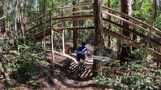
Popular Nambucca Heads Mountain Biking Trails
• 90 ★ 4.0 • 1,430 ft • 22 ft • 473 •
Popular green difficulty singletrack. This mountain bike primary trail can be used one direction. On average it takes 1 minutes to complete this trail.
• 95 ★ 4.0 • 524 ft • 0 ft • 450 •
Popular green difficulty singletrack. This mountain bike primary trail can be used one direction. On average it takes 1 minutes to complete this trail.
• 95 ★ 5.0 • 1 mile • 88 ft • 430 •
the Ride back up the hill form Muffin Top to ... a little bit of double track to catch your breath but an easyish climb ... keep a look out for the 'totem poles'
• 55 ★ 4.0 • 5,135 ft • 25 ft • 421 •
Fast rollercoaster into 'sideshow ally' with easy jumps to the edge of the main line. look for 'sideshow bob' towards the end of the trail ... a great jump for beginners and experts alike.
• 60 ★ 5.0 • 2 miles • 139 ft • 418 •
Moderately popular green difficulty singletrack. This mountain bike primary trail can be used one direction. On average it takes 11 minutes to complete this trail.
• 85 ★ 5.0 • 873 ft • 0 ft • 404 •
Popular blue difficulty singletrack. This mountain bike primary trail can be used one direction. On average it takes 1 minutes to complete this trail.
• 65 ★ 5.0 • 1,594 ft • 48 ft • 399 •
Moderately popular blue difficulty singletrack. This mountain bike primary trail can be used one direction. On average it takes 2 minutes to complete this trail.
• 50 ★ 4.0 • 1,598 ft • 92 ft • 398 •
Moderately popular green difficulty singletrack. This mountain bike primary trail can be used one direction with a 92 ft blue climb. On average it takes 2 minutes to complete this trail.
Nambucca Heads Mountain Bike Routes
1 mile • 110 ft • 1 • Point to Point •
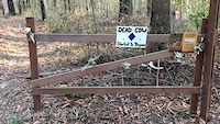
The Dead Cow loop is marked with magenta coloured signage, and is accessed via the BMW trail on the #1...
★ 3.0 • 5 miles • 448 ft • 10 • Loop •
The original Jacks Ridge loop with all the iconic features including the fast " " and "Big Boris Log...
3 miles • 144 ft • 6 • Loop •
The Teagues loop is a "Family Friendly" route perfect for beginners and less experienced and/or younger...
3 miles • 226 ft • 5 •
The Northern Loop begins at the toilet end of the carpark, and duplicates the #5 Bili Bili loop for the...
2 miles • 149 ft • 6 • Loop •
The Bili Bili Loop is a great little loop if you're short on time but want some fun flowy trails to blow...
3 miles • 251 ft • 9 • Loop •
The Western Loop is marked with orange #3 signage, and begins just near the trailhead map structure. It...
Photos of Nambucca Heads Mountain Bike
Recent Trail Reports
| status | trail | date | condition | info | user |
|---|---|---|---|---|---|
| Snakes and Ladders | Jan 17, 2026 @ 6:22pm (Australia/Sydney) Jan 16, 2026 | Unknown | ranoptic | ||
| Dead Cow | May 24, 2024 @ 5:40am May 24, 2024 | Ideal | Msmyth | ||
| Get Yet Pants Off | May 24, 2024 @ 5:40am May 24, 2024 | Ideal | Msmyth | ||
| Nose Dive | May 24, 2024 @ 5:40am May 24, 2024 | Ideal | Msmyth | ||
| Roller Coaster | May 24, 2024 @ 5:40am May 24, 2024 | Ideal | Msmyth | ||
| BMW Loop | Mar 23, 2024 @ 1:47am Mar 23, 2024 | Ideal | DrToxic | ||
| Loggers Lane | Mar 23, 2024 @ 1:47am Mar 23, 2024 | Ideal | DrToxic | ||
| Totem Poles to Picadilly | Mar 23, 2024 @ 1:47am Mar 23, 2024 | Ideal | DrToxic | ||
| Lost Luggage | Mar 23, 2024 @ 1:47am Mar 23, 2024 | Ideal | DrToxic | ||
| Seesaw | Mar 23, 2024 @ 1:47am Mar 23, 2024 | Ideal | DrToxic |
Activity Feed
| username | action | type | title | date |
|---|---|---|---|---|
| organm | wishlist | route | activity #96129617 and 2 more | Jun 2, 2026 @ 7:18pm Jun 2, 2026 |
| JacksRidgeMTBPark | add | route | activity #95029499 | May 19, 2026 @ 3:37am May 19, 2026 |
| southsydney12 | wishlist | trail | activity #88947462 | Feb 15, 2026 @ 4:15am Feb 15, 2026 |
| LeighBerkley | ridden | trail | activity #88374100 and 3 more | Feb 5, 2026 @ 5:42am Feb 5, 2026 |
| Sneaky-Pete | add | karma | activity #87682573 | Jan 23, 2026 @ 10:34am Jan 23, 2026 |
Recent Comments
| username | type | title | comment | date |
|---|---|---|---|---|
| trail | The jump and double combo is really fun.... | Jul 26, 2022 @ 9:23pm Jul 26, 2022 | ||
| trail | Brilliant train would recommend (proceed with... | Dec 27, 2021 @ 6:27pm Dec 27, 2021 | ||
| trail | Don’t bother, parts are overgrown and the... | Sep 26, 2021 @ 5:59am Sep 26, 2021 | ||
| trail | Sideshow Bob is not a jump. | Oct 16, 2020 @ 11:56pm Oct 16, 2020 | ||
| trail | Like it says, fast! | Sep 16, 2020 @ 10:08pm Sep 16, 2020 |
Local Badges
-

10 Blue Trails198 awarded -

Epic Ride Climb 2k23 awarded -

Climbing 10k Badge19 awarded -

Climbing 100k Badge0 awarded -

Epic Ride Descent 2k24 awarded -

Descent 10k Badge19 awarded
Activity Type Stats
| activitytype | trails | distance | descent | descent distance | total vertical | rating | global rank | state rank | photos | reports | routes | ridelogs |
|---|---|---|---|---|---|---|---|---|---|---|---|---|
| Mountain Bike | 52 | 43 miles | 7,126 ft | 19 miles | 1,535 ft | #1,719 | #88 | 57 | 339 | 9 | 4,159 | |
| E-Bike | 24 | 11 miles | 850 ft | 4 miles | 131 ft | #4,101 | #192 | 270 | 2 | 342 | ||
| Hike | 48 | 39 miles | 6,778 ft | 18 miles | 1,532 ft | #4,608 | #135 | 302 | 252 | |||
| Trail Running | 49 | 39 miles | 6,831 ft | 18 miles | 1,532 ft | #4,004 | #122 | 314 | 16 |
Frequently Asked Questions About Nambucca Heads
▼
What are the best places to ride in Nambucca Heads?
Nambucca Heads has 3 areas to explore for mountain biking. The top rated areas are:
▼
What are the highest rated mountain biking trails in Nambucca Heads?
The highest rated mountain biking trails in Nambucca Heads are:
- Dead Cow (4.3/5)
- The Pines (4.2/5)
- Use the Force (4.1/5)
- Get Yet Pants Off (4.1/5)
- Trolls Lair/Troll Marsh (4.1/5)
▼
What is the best time of the year to ride in Nambucca Heads?
Based on ride log data, the most popular months to ride in Nambucca Heads are:
- October (62 activities)
- November (60 activities)
- December (58 activities)
▼
Where can I park to ride in Nambucca Heads?
There are 1 parking locations listed in Nambucca Heads. The most popular parking spots are:
Activities
Trails
Points of Interest
- By johncitizen07
 NVCC & contributors
 - Admins: stuartrichardson, NVCC, JacksRidgeMTBPark
- #12754 - 10,161 views
- nambucca heads activity log | embed map of Nambucca Heads mountain bike trails | nambucca heads mountain biking points of interest
Downloading of trail gps tracks in kml & gpx formats is enabled for Nambucca Heads.
You must login to download files.