close
-
Layers w
- Weather Layers
- Pro
- Pro
- Pro
- Pro
- Pro
- Pro
- More Layers
- Pro
- Pro
- Pro
- Pro
-
Upgrade to

3D
Trail Conditions
- Unknown
- Snow Groomed
- Snow Packed
- Snow Covered
- Snow Cover Partial
- Freeze/thaw Cycle
- Icy
- Prevalent Mud
- Wet
- Variable
- Ideal
- Dry
- Very Dry
Trail Flow (Ridden Direction)
Trailforks scans users ridelogs to determine the most popular direction each trail is ridden. A good flowing trail network will have most trails flowing in a single direction according to their intension.
The colour categories are based on what percentage of riders are riding a trail in its intended direction.
The colour categories are based on what percentage of riders are riding a trail in its intended direction.
- > 96%
- > 90%
- > 80%
- > 70%
- > 50%
- < 50%
- bi-directional trail
- no data
Trail Last Ridden
Trailforks scans ridelogs to determine the last time a trail was ridden.
- < 2 days
- < 1 week
- < 2 weeks
- < 1 month
- < 6 months
- > 6 months
Trail Ridden Direction
The intended direction a trail should be ridden.
- Downhill Only
- Downhill Primary
- Both Directions
- Uphill Primary
- Uphill Only
- One Direction
Contribute Details
Colors indicate trail is missing specified detail.
- Description
- Photos
- Description & Photos
- Videos
Trail Popularity ?
Trailforks scans ridelogs to determine which trails are ridden the most in the last 9 months.
Trails are compared with nearby trails in the same city region with a possible 25 colour shades.
Think of this as a heatmap, more rides = more kinetic energy = warmer colors.
- most popular
- popular
- less popular
- not popular
ATV/ORV/OHV Filter
Max Vehicle Width
inches
US Cell Coverage
Legend

Radar Time
Activity Recordings
Trailforks uses anonymized public activity data.
?
Activity Recordings
Trailforks uses anonymized public activity data.
?
Personal Heatmap
▶
Activity Types
all
/
none
▶
Options
2
Date range
month
–
Winter Trails
Warning
A routing network for winter maps does not exist. Selecting trails using the winter trails layer has been disabled.
Missing Trails
Most Popular
Least Popular
Trails are colored based on popularity. The more popular a trail is, the more red. Less popular trails trend towards green.
Jump Magnitude Heatmap
Heatmap of where riders jump on trails. Zoom in to see individual jumps, click circles to view jump details.
BC Backroad Status
![map legend]()
Service Road Atlas is a free to use, community-driven service for viewing and creating reports on the numerous back-country service roads around B.C. and Alberta.

Slope Aspect
Direction the slope faces
Trails Deemphasized
Trails are shown in grey.
Only show trails with no bike usage.
Suggested Layers
Based on selected activity type
Save the current map location and zoom level as your default home location whenever this page is loaded.
Save
No description for Naramata has been added yet!
Login or register to submit one.
Activities Click to view
- Mountain Bike
13 trails
- E-Bike
12 trails
- Gravel Bike
0 trails
- Winter Fat Bike
0 trails
- Horse
5 trails
- Hike
12 trails
- Trail Running
11 trails
Region Details
- 2
- 10
- 1
Region Status
Caution as of Feb 14, 2026Stats
- Avg Trail Rating
- Trails (view details)
- 13
- Trails Mountain Bike
- 13
- Trails E-Bike
- 12
- Trails Horse
- 5
- Trails Hike
- 12
- Trails Trail Running
- 11
- Trails ATV/ORV/OHV
- 1
- Total Distance
- 6 miles
- Total Descent Distance
- 5 miles
- Total Descent
- 2,257 ft
- Total Vertical
- 2,592 ft
- Highest Trailhead
- 3,778 ft
- Reports
- 20
- Photos
- 14
- Ridden Counter
- 410
Articles
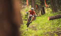
Event Recap: Trails, Tech & Good Times in the Okanagan at MegaVolt 2025
Jun 12, 2025 from pinkbike.com
This year’s edition brought together 150 riders for three sun-drenched days in Naramata, BC, on the legendary Three Blind Mice trail network.
MegaVolt 2025 Wrap-Up: Three Days of Stoke, Smiles & Sweet Trails
Jun 3, 2025 from pinkbike.com
The grand finale was Sunday’s eEnduro—8.5 kilometers of adrenaline-pumping, grin-inducing downhill across three stages.
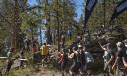
Event Report: Hill Climbs, Heckles & High-Fives: MegaVolt Day 1
Jun 2, 2025 from pinkbike.com
The 2025 MegaVolt eMTB Festival kicked off in Naramata with sunny skies, stoke in the air, and a warm welcome.
Video & Photo Recap: The 2024 Mega Volt eMTB Festival
Jun 11, 2024 from pinkbike.com
Three days of challenges, group rides and more.
Sub Regions
-
Chute Lake
- 1
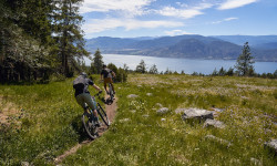
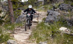
Popular Naramata Mountain Biking Trails
• 100 ★ 4.0 • 1 mile • 3 ft • 81 •
A combination of single and double track. This is a trail where if you want to hold it wide open for its entire length, you can! Fun pinned for all levels. Watch the exit back onto the KVR, it is fairly loose !!
• 75 ★ 3.5 • 1 mile • 5 ft • 15 •
Fun Okanagan single track goodness! Watch where you are going closely to stay on the trail! It bisects a number of game trails and is fairly raw in sections. This trail spits you out at Chute Lake Road turnoff.
• 40 ★ 0.0 • 3 miles • 206 ft • 14 •
Downcountry anyone?! Woodwackers is a trail that has recently been brought back to life and is steeped Okanagan history. Originally developed by a group of outdoor enthusiasts, The Naramata Woodwackers, over 40 years ago, this trail can...
• 90 ★ 5.0 • 4,895 ft • 3 ft • 6 •
Popular blue difficulty singletrack. This mountain bike primary trail can be used downhill primary.
• 50 ★ 0.0 • 3,415 ft • 26 ft • 5 •
Moderately popular blue difficulty singletrack. This mountain bike primary trail can be used both directions.
• 60 ★ 0.0 • 1,079 ft • 0 ft • 2 •
Moderately popular blue difficulty singletrack. This mountain bike primary trail can be used both directions and has a easy overall physical rating.
• 5 ★ 0.0 • 1,572 ft • 10 ft • 2 •
Short and more tacky to start off Woodwackers. Turn left off of the KVR onto Elinor Lake FSR and then right on Rd to get to the trailhead
Naramata Mountain Bike Routes
★ 1.0 • 15 miles • 2,565 ft • 8 •
MegaVolt eFondo is meant to test the rider and the bike in an overland style race without strong focus on...
16 miles • 3,120 ft • 9 •
one big up, three Enduros E1 - Fast!! E2 - Tech with an uphill finish! E3 - Long a bit of everything, and...
17 miles • 3,386 ft • 7 •
Version 1 with timing starting at beach and ending at workman place.
29 miles • 5,221 ft • 14 •
draft route starting and finishing in Naramata
Recent Trail Reports
| status | trail | date | condition | info | user |
|---|---|---|---|---|---|
| 2 Moose | Feb 14, 2026 @ 10:29am (America/Creston) Feb 14, 2026 | Ideal | Joehiker | ||
| Tote Road Trail | Jan 27, 2026 @ 2:22pm (America/Creston) Jan 27, 2026 | Ideal | richardjblackwell | ||
| Woodwackers | Aug 3, 2025 @ 6:49am Aug 3, 2025 | Variable | babesbikesbeers | ||
| Upper Toad | Jun 28, 2025 @ 11:01am Jun 28, 2025 | Dry | ur55 | ||
| Woodwackers Black | May 28, 2023 @ 5:43pm May 28, 2023 | Variable | deldridge | ||
| Ken's Trail | Jul 22, 2020 @ 9:54am Jul 22, 2020 | Dry | Taylored |
Activity Feed
| username | action | type | title | date |
|---|---|---|---|---|
| Spiza | wishlist | route | activity #95822397 | May 29, 2026 @ 9:08pm May 29, 2026 |
| andrewdrouin | wishlist | trail | activity #94877750 | May 17, 2026 @ 1:13am May 17, 2026 |
| ThibaultPZg923 | ridden | trail | activity #94835735 | May 16, 2026 @ 11:15am May 16, 2026 |
| westcoastatheart | wishlist | route | activity #91184306 | Mar 23, 2026 @ 9:55pm Mar 23, 2026 |
| Joehiker | add | report | activity #88960406 | Feb 15, 2026 @ 8:01am Feb 15, 2026 |
Recent Comments
| username | type | title | comment | date |
|---|---|---|---|---|
| trail | All clear and running sweetly today | Jul 11, 2023 @ 1:15pm Jul 11, 2023 | ||
| trail | Dirt bikes are using this area now. Really... | May 9, 2022 @ 1:10pm May 9, 2022 | ||
| trail | Cool | Oct 31, 2021 @ 9:26pm Oct 31, 2021 | ||
| trail | do not ride this trail this trail is on... | Aug 6, 2021 @ 3:49pm Aug 6, 2021 | ||
| trail | The trail is super fun but technical at the... | Oct 24, 2020 @ 9:49pm Oct 24, 2020 |
Local Badges
-

Epic Mountain Bike Climb 2k0 awarded -

Climbing 10k Badge0 awarded -

Mountain Biking 100k Badge0 awarded -

Epic Ride Descent 2k0 awarded -

Descent 10k Badge0 awarded -

Descent 100k Badge0 awarded
Activity Type Stats
| activitytype | trails | distance | descent | descent distance | total vertical | rating | global rank | state rank | photos | reports | routes | ridelogs |
|---|---|---|---|---|---|---|---|---|---|---|---|---|
| Mountain Bike | 13 | 6 miles | 2,257 ft | 5 miles | 2,592 ft | #6,177 | #134 | 14 | 20 | 14 | 1,120 | |
| E-Bike | 12 | 6 miles | 2,241 ft | 5 miles | 1,995 ft | #6,591 | #116 | 19 | 6 | 143 | ||
| Horse | 5 | #3,044 | #84 | 2 | 4 | |||||||
| Hike | 12 | 6 miles | 2,241 ft | 5 miles | 1,995 ft | #10,303 | #164 | 19 | 3 | 68 | ||
| Trail Running | 11 | 6 miles | 2,241 ft | 5 miles | 1,995 ft | #9,909 | #157 | 19 | 2 | 28 | ||
| ATV/ORV/OHV | 1 | 9 |
Frequently Asked Questions About Naramata
▼
What are the best places to ride in Naramata?
Naramata has 1 areas to explore for mountain biking. The top rated areas are:
▼
What are the highest rated mountain biking trails in Naramata?
The highest rated mountain biking trails in Naramata are:
- Upper Toad (4.1/5)
- Tote Road Trail (4/5)
- Ken's Trail (3.9/5)
- Double Track Short Cut (0/5)
- 2 Moose (0/5)
▼
What is the best time of the year to ride in Naramata?
Based on ride log data, the most popular months to ride in Naramata are:
- July (62 activities)
- June (37 activities)
- May (27 activities)
▼
Where can I park to ride in Naramata?
Check the Naramata trail map for trailhead and parking information. Community members regularly update access and parking details for trails in the area.
Activities
- By 1partatatime
 PACA & contributors
 - Admins: canadianenduro, PACA, 1partatatime, PACApenticton
- #37132 - 8,607 views
- naramata activity log | embed map of Naramata mountain bike trails | naramata mountain biking points of interest
Downloading of trail gps tracks in kml & gpx formats is enabled for Naramata.
You must login to download files.