close
-
Layers w
- Weather Layers
- Pro
- Pro
- Pro
- Pro
- Pro
- Pro
- More Layers
- Pro
- Pro
- Pro
- Pro
-
Upgrade to

3D
Trail Conditions
- Unknown
- Snow Groomed
- Snow Packed
- Snow Covered
- Snow Cover Partial
- Freeze/thaw Cycle
- Icy
- Prevalent Mud
- Wet
- Variable
- Ideal
- Dry
- Very Dry
Trail Flow (Ridden Direction)
Trailforks scans users ridelogs to determine the most popular direction each trail is ridden. A good flowing trail network will have most trails flowing in a single direction according to their intension.
The colour categories are based on what percentage of riders are riding a trail in its intended direction.
The colour categories are based on what percentage of riders are riding a trail in its intended direction.
- > 96%
- > 90%
- > 80%
- > 70%
- > 50%
- < 50%
- bi-directional trail
- no data
Trail Last Ridden
Trailforks scans ridelogs to determine the last time a trail was ridden.
- < 2 days
- < 1 week
- < 2 weeks
- < 1 month
- < 6 months
- > 6 months
Trail Ridden Direction
The intended direction a trail should be ridden.
- Downhill Only
- Downhill Primary
- Both Directions
- Uphill Primary
- Uphill Only
- One Direction
Contribute Details
Colors indicate trail is missing specified detail.
- Description
- Photos
- Description & Photos
- Videos
Trail Popularity ?
Trailforks scans ridelogs to determine which trails are ridden the most in the last 9 months.
Trails are compared with nearby trails in the same city region with a possible 25 colour shades.
Think of this as a heatmap, more rides = more kinetic energy = warmer colors.
- most popular
- popular
- less popular
- not popular
ATV/ORV/OHV Filter
Max Vehicle Width
inches
US Cell Coverage
Legend

Radar Time
Activity Recordings
Trailforks uses anonymized public activity data.
?
Activity Recordings
Trailforks uses anonymized public activity data.
?
Personal Heatmap
▶
Activity Types
all
/
none
▶
Options
2
Date range
month
–
Winter Trails
Warning
A routing network for winter maps does not exist. Selecting trails using the winter trails layer has been disabled.
Missing Trails
Most Popular
Least Popular
Trails are colored based on popularity. The more popular a trail is, the more red. Less popular trails trend towards green.
Jump Magnitude Heatmap
Heatmap of where riders jump on trails. Zoom in to see individual jumps, click circles to view jump details.
BC Backroad Status
![map legend]()
Service Road Atlas is a free to use, community-driven service for viewing and creating reports on the numerous back-country service roads around B.C. and Alberta.

Slope Aspect
Direction the slope faces
Trails Deemphasized
Trails are shown in grey.
Only show trails with no bike usage.
Suggested Layers
Based on selected activity type
Save the current map location and zoom level as your default home location whenever this page is loaded.
SaveNasby is a working forest with ongoing logging. Check in with Ernslaw One Ltd forest headquarters in Naseby for up to date info on the forest status as portions can can closed due to logging operations or fire risk. Forestry operations and vehicles as well as walkers have right of way.
There's up to 50kms of trails ranging from Beginner (green) through to Expert (black diamond). Trails are continuously being built, but don't expect an up to date map anywhere. All trails have recently been signposted which overcomes the previous problems of navigation. Hopefully a signage project expected to start will solve a few of the getting lost issues.
There's up to 50kms of trails ranging from Beginner (green) through to Expert (black diamond). Trails are continuously being built, but don't expect an up to date map anywhere. All trails have recently been signposted which overcomes the previous problems of navigation. Hopefully a signage project expected to start will solve a few of the getting lost issues.
Primary Trail Type: Cross-Country
Land Status: Community Forest
 google parking directions
 Access Info:
The main car park is at the end of Swimming Dam Rd.
Activities Click to view
- Mountain Bike
109 trails
- E-Bike
47 trails
- Hike
108 trails
- Trail Running
108 trails
Region Details
- 8
- 14
- 42
- 34
- 7
Region Status
Open as of Jan 26, 2026Stats
- Avg Trail Rating
- Trails (view details)
- 109
- Trails Mountain Bike
- 111
- Trails E-Bike
- 47
- Trails Hike
- 108
- Trails Trail Running
- 108
- Total Distance
- 41 miles
- Total Descent
- 5,916 ft
- Total Vertical
- 475 ft
- Highest Trailhead
- 2,346 ft
- Reports
- 188
- Photos
- 51
- Ridden Counter
- 8,270
Popular Naseby Forest Mountain Biking Trails
• 80 ★ 3.8 • 2 miles • 27 ft • 250 •
Popular blue difficulty singletrack. This mountain bike primary trail can be used downhill primary. On average it takes 5 minutes to complete this trail.
• 100 ★ 2.0 • 489 ft • 2 ft • 236 •
Popular blue difficulty singletrack. This mountain bike primary trail can be used both directions. On average it takes 1 minutes to complete this trail.
• 100 ★ 4.5 • 1,880 ft • 0 ft • 225 •
A fun Grade 3 trail that starts at the Mt Ida water race. A couple of rocks and roots and a few forks and jumps and a couple of sharp corners to keep you in your toes.
• 95 ★ 4.5 • 3,169 ft • 59 ft • 225 •
Popular green difficulty singletrack. This mountain bike primary trail can be used both directions. On average it takes 4 minutes to complete this trail.
• 100 ★ 3.0 • 423 ft • 6 ft • 209 •
Popular blue difficulty singletrack. This mountain bike primary trail can be used both directions. On average it takes 1 minutes to complete this trail.
• 60 ★ 4.0 • 1,404 ft • 10 ft • 190 •
Fast run down to the camp ground. Shared use so be nice to pedestrians Short grungy climb at the end to the camp ground
• 75 ★ 4.6 • 486 ft • 0 ft • 188 •
Popular blue difficulty singletrack. This mountain bike primary trail can be used downhill primary. On average it takes minutes to complete this trail.
Naseby Forest Mountain Bike Routes
★ 5.0 • 7 miles • 664 ft • 0 • Loop •
Torpedo7 12 Hour Naseby Challenge 2015 Torpedo7 and Mountain Biking Otago got together to run the 11th...
• 8 miles • 715 ft • 10 •
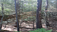
Photos of Naseby Forest Mountain Bike
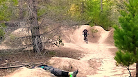
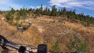
Videos of Naseby Forest Mountain Bike
trail: Deep Lead
0:12 |
124 |
May 10, 2023

trail: Gold Handler
0:18 |
85 |
Apr 7, 2023
trail: Moonscape
0:07 |
301 |
Nov 9, 2021
trail: Magic Carpet
7:50 |
125 |
Mar 13, 2024 , Naseby

trail: Hazy and Confused
10:38 |
180 |
Mar 13, 2024 , Naseby

trail: Undaunted
9:59 |
538 |
Apr 28, 2021 , Naseby

trail: Hepi Highway
5:36 |
914 |
Apr 19, 2021 , Naseby

trail: Blu Man
4:38 |
631 |
Apr 4, 2021 , Naseby
Recent Trail Reports
| status | trail | date | condition | info | user |
|---|---|---|---|---|---|
| Gerald's Run | Jan 26, 2026 @ 11:08pm (Pacific/Auckland) Jan 26, 2026 | Unknown | Kmccarlie | ||
| Deep Lead | Jan 26, 2026 @ 11:08pm (Pacific/Auckland) Jan 26, 2026 | Wet | Kmccarlie | ||
| Lolly Woman's Gully | Dec 12, 2025 @ 9:34pm (Pacific/Auckland) Dec 12, 2025 | Dry | cmcalpine1169 | ||
| Moonscape | Dec 12, 2025 @ 9:33pm (Pacific/Auckland) Dec 12, 2025 | Ideal | cmcalpine1169 | ||
| Hepi Highway | Dec 12, 2025 @ 9:30pm (Pacific/Auckland) Dec 12, 2025 | Unknown | cmcalpine1169 | ||
| Blu Man | Dec 12, 2025 @ 2:39pm (Pacific/Auckland) Dec 11, 2025 | Ideal | cmcalpine1169 | ||
| Poor Man's | Dec 11, 2025 @ 4:51pm (Pacific/Auckland) Dec 10, 2025 | Dry | cmcalpine1169 | ||
| Species Track | Dec 11, 2025 @ 4:50pm (Pacific/Auckland) Dec 10, 2025 | Dry | cmcalpine1169 | ||
| Magic Carpet | Dec 11, 2025 @ 4:48pm (Pacific/Auckland) Dec 10, 2025 | Ideal | cmcalpine1169 | ||
| Collarbone Alley | Apr 7, 2025 @ 3:46pm Apr 7, 2025 | Ideal | rizzimizzi |
Activity Feed
| username | action | type | title | date |
|---|---|---|---|---|
| Ttocsremlap | wishlist | trail | activity #92647725 | Apr 15, 2026 @ 2:12am Apr 15, 2026 |
| RustyTg0kpr | wishlist | region | activity #91870704 | Apr 3, 2026 @ 10:31pm Apr 3, 2026 |
| Brad250 | wishlist | trail | activity #91802906 and 4 more | Apr 2, 2026 @ 11:07pm Apr 2, 2026 |
| jeannette177 | wishlist | trail | activity #91130494 | Mar 23, 2026 @ 12:04am Mar 23, 2026 |
| PhilMmWSSB | wishlist | trail | activity #91024486 and 3 more | Mar 21, 2026 @ 2:11pm Mar 21, 2026 |
Recent Comments
| username | type | title | comment | date |
|---|---|---|---|---|
| trail | Inaccessible - covered in slash | Jan 31, 2026 @ 1:56pm Jan 31, 2026 | ||
| trail | An a to b trail but some nice little jumps off... | Nov 16, 2024 @ 3:56pm Nov 16, 2024 | ||
| trail | Just an a to b but some nice little jumps on... | Nov 16, 2024 @ 3:55pm Nov 16, 2024 | ||
| trail | Last 3rd is missing, fire break had gone... | Nov 16, 2024 @ 3:51pm Nov 16, 2024 | ||
| trail | Best trail here so far. Only 2 drops which you... | Nov 16, 2024 @ 3:48pm Nov 16, 2024 |
Nearby Areas
| name | distance | ||||
|---|---|---|---|---|---|
| Saint Bathans Area | 18.6 km |
Local Badges
-

Completionist0 awarded
Activity Type Stats
| activitytype | trails | distance | descent | descent distance | total vertical | rating | global rank | state rank | photos | reports | routes | ridelogs |
|---|---|---|---|---|---|---|---|---|---|---|---|---|
| Mountain Bike | 109 | 41 miles | 5,915 ft | 18 miles | 476 ft | #1,398 | #49 | 51 | 189 | 2 | 2,976 | |
| E-Bike | 47 | 16 miles | 1,785 ft | 5 miles | 466 ft | #2,861 | #75 | 99 | 194 | |||
| Hike | 108 | 41 miles | 5,715 ft | 17 miles | 476 ft | #3,141 | #50 | 189 | 44 | |||
| Trail Running | 108 | 41 miles | 5,715 ft | 17 miles | 476 ft | #2,276 | #33 | 189 | 354 |
Frequently Asked Questions About Naseby Forest
▼
What are the highest rated mountain biking trails in Naseby Forest?
The highest rated mountain biking trails in Naseby Forest are:
- Flumes (4.3/5)
- Moonscape (4.2/5)
- Look Out (4.2/5)
- Memorial Lane (4.1/5)
- Undertaker (4.1/5)
▼
What is the best time of the year to ride in Naseby Forest?
Based on ride log data, the most popular months to ride in Naseby Forest are:
- December (41 activities)
- January (31 activities)
- October (23 activities)
▼
Where can I park to ride in Naseby Forest?
There are 3 parking locations listed in Naseby Forest. The most popular parking spots are: View all parking and trailhead locations on the map to plan your visit.
▼
What is the longest trail in Naseby Forest?
The longest trail in Naseby Forest is Mount Ida Water Race at 2.3 miles. View all trails sorted by distance.
Activities
Trails
Points of Interest
- By YogiNZ & contributors
- Admins: MBO, Dubnyk, NDCT
- #8329 - 16,627 views
- naseby forest activity log | embed map of Naseby Forest mountain bike trails | naseby forest mountain biking points of interest
Downloading of trail gps tracks in kml & gpx formats is enabled for Naseby Forest.
You must login to download files.