close
-
Layers w
- Weather Layers
- Pro
- Pro
- Pro
- Pro
- Pro
- Pro
- More Layers
- Pro
- Pro
- Pro
- Pro
-
Upgrade to

3D
Trail Conditions
- Unknown
- Snow Groomed
- Snow Packed
- Snow Covered
- Snow Cover Partial
- Freeze/thaw Cycle
- Icy
- Prevalent Mud
- Wet
- Variable
- Ideal
- Dry
- Very Dry
Trail Flow (Ridden Direction)
Trailforks scans users ridelogs to determine the most popular direction each trail is ridden. A good flowing trail network will have most trails flowing in a single direction according to their intension.
The colour categories are based on what percentage of riders are riding a trail in its intended direction.
The colour categories are based on what percentage of riders are riding a trail in its intended direction.
- > 96%
- > 90%
- > 80%
- > 70%
- > 50%
- < 50%
- bi-directional trail
- no data
Trail Last Ridden
Trailforks scans ridelogs to determine the last time a trail was ridden.
- < 2 days
- < 1 week
- < 2 weeks
- < 1 month
- < 6 months
- > 6 months
Trail Ridden Direction
The intended direction a trail should be ridden.
- Downhill Only
- Downhill Primary
- Both Directions
- Uphill Primary
- Uphill Only
- One Direction
Contribute Details
Colors indicate trail is missing specified detail.
- Description
- Photos
- Description & Photos
- Videos
Trail Popularity ?
Trailforks scans ridelogs to determine which trails are ridden the most in the last 9 months.
Trails are compared with nearby trails in the same city region with a possible 25 colour shades.
Think of this as a heatmap, more rides = more kinetic energy = warmer colors.
- most popular
- popular
- less popular
- not popular
ATV/ORV/OHV Filter
Max Vehicle Width
inches
US Cell Coverage
Legend

Radar Time
Activity Recordings
Trailforks uses anonymized public activity data.
?
Activity Recordings
Trailforks uses anonymized public activity data.
?
Personal Heatmap
▶
Activity Types
all
/
none
▶
Options
2
Date range
month
–
Winter Trails
Warning
A routing network for winter maps does not exist. Selecting trails using the winter trails layer has been disabled.
Missing Trails
Most Popular
Least Popular
Trails are colored based on popularity. The more popular a trail is, the more red. Less popular trails trend towards green.
Jump Magnitude Heatmap
Heatmap of where riders jump on trails. Zoom in to see individual jumps, click circles to view jump details.
BC Backroad Status
![map legend]()
Service Road Atlas is a free to use, community-driven service for viewing and creating reports on the numerous back-country service roads around B.C. and Alberta.

Slope Aspect
Direction the slope faces
Trails Deemphasized
Trails are shown in grey.
Only show trails with no bike usage.
Suggested Layers
Based on selected activity type
Save the current map location and zoom level as your default home location whenever this page is loaded.
Save
No description for Nashville has been added yet!
Login or register to submit one.

IMBA Ride Center
Brown County
Activities Click to view
- Mountain Bike
55 trails
- E-Bike
38 trails
- Gravel Bike
0 trails
- Adaptive Bike
0 trails
- Winter Fat Bike
0 trails
- Hike
96 trails
- Trail Running
97 trails
Region Details
- 7
- 10
- 27
- 10
- 1
Region Status
Caution as of 2 daysLocal Trail Association
Stats
- Avg Trail Rating
- Trails (view details)
- 87
- Trails Mountain Bike
- 60
- Trails E-Bike
- 38
- Trails Horse
- 3
- Trails Hike
- 97
- Trails Trail Running
- 97
- Trails Dirtbike/Moto
- 1
- Trails Observed Trials
- 1
- Trails ATV/ORV/OHV
- 1
- Trails Snowshoe
- 1
- Trails Downhill Ski
- 1
- Trails Backcountry Ski
- 1
- Trails Nordic Ski
- 1
- Total Distance
- 195 miles
- Total Descent
- 22,312 ft
- Total Vertical
- 506 ft
- Highest Trailhead
- 1,053 ft
- Reports
- 17,101
- Photos
- 345
- Ridden Counter
- 25,043
Sub Regions
-
Brown County State Park
- 5
- 4
- 5
- 1
-
Hoosier National Forest
- 5
- 17
- 2
-
Yellowwood State Forest
- 5
- 3
Popular Nashville Mountain Biking Trails
• 80 ★ 0.0 • 430 ft • 33 ft • 212 •
This is a short, black diamond, bi-directional trail that connects the intersection of / 10 O'Clock Line with .
• 75 ★ 3.0 • 4,475 ft • 4 ft • 160 •
is an optional trail to get from Crooked Creek to the north part of without riding the west side of . is an old forest road that has narrowed to single track for most of its length and has few technical features other than some small...
• 65 ★ 5.0 • 5 miles • 789 ft • 156 •
is a very rugged trail. There are no bathrooms, no access to water and cell service is, at best, inconsistent, but mostly non-existent. The trail connects to Brown County State Park via 10 'O Clock Line trail. The area is hunted; wear...
• 70 ★ 3.5 • 3 miles • 28 ft • 131 •
The northern end of this trail is doubletrack in Yellowwood State Forest. The southern end is in Hoosier National Forest and is primarily narrow singletrack. This trail is open to hikers and equestrians, so please be ready to share the...
• 65 ★ 4.0 • 2,169 ft • 0 ft • 130 •
is the longest of four short trails that connect and . It follows an old road bed along the top of a ridgeline where the forest has now grown back to the point that the trail is single track. In the spring this has a few areas that can...
• 70 ★ 0.0 • 2 miles • 179 ft • 125 •
Old country road that was closed years ago. Mix of single / double width track & gravel. Accessible from: Connector on Nebo Ridge trail Comb's Rd (on the north end) Country Road 1140 North (on the south end)
• 65 ★ 4.3 • 8 miles • 1,145 ft • 107 •
Requires riding permit - see Hoosier National Forest website Regardless of the trailhead you start from, you have a big climb ahead of you to reach the ridgetop. Starting from the North, the climb up the old fire road tends to stay...
• 45 ★ 4.0 • 2 miles • 257 ft • 57 •
The north part of this trail is forest double track. A little more than half way through there is a steep descent of about 200-300 yards and the trail then makes a slow meandering descent to a stream bed. After crossing the stream...
Nashville Mountain Bike Routes
★ 5.0 • 20 miles • 2,133 ft • 12 • Loop •
Brown County Mountain Biking Featured Route #5 Marked on trail signs with ORANGE stickers Limekiln is...
★ 5.0 • 30 miles • 2,538 ft • 12 • Out & Back •
Brown County Mountain Biking Featured Route #6 Route not marked Limekiln is directional depending on day...
★ 5.0 • 30 miles • 2,529 ft • 12 • Out & Back •
Brown County Mountain Biking Featured Route #6 Route not marked Limekiln is directional depending on day...
★ 5.0 • 17 miles • 1,469 ft • 8 • Out & Back •
Brown County Mountain Biking Featured Route #4 Marked on trail signs with YELLOW stickers
★ 5.0 • 46 miles • 4,677 ft • 21 • Loop •
Brown County Mountain Biking Featured Route #7 Route not marked Limekiln is directional depending on day...
★ 5.0 • 46 miles • 4,685 ft • 21 • Loop •
Brown County Mountain Biking Featured Route #7 Route not marked Limekiln is directional depending on day...
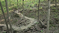
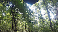
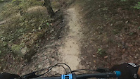
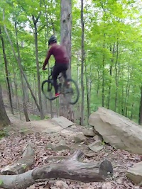
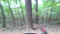
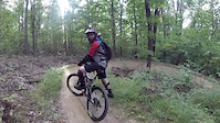
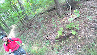
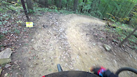
Photos of Nashville Mountain Bike
Videos of Nashville Mountain Bike
trail: BOBCAT
0:08 |
|
Dec 6, 2024
trail: HOBBS HOLLOW
9:35 |
129 |
Dec 26, 2021
trail: HOBBS HOLLOW
0:48 |
166 |
Oct 20, 2021
trail: HOBBS HOLLOW
0:13 |
363 |
May 17, 2021
trail: HOBBS HOLLOW
4:09 |
234 |
Nov 13, 2018
trail: HOBBS HOLLOW
10:00 |
299 |
Nov 13, 2018
trail: HOBBS HOLLOW
2:21 |
84 |
Nov 13, 2018
trail: HOBBS HOLLOW
3:39 |
107 |
Nov 12, 2018
Current Trail Warnings
| status | trail | date | condition | user | info |
|---|---|---|---|---|---|
| WEST GATE | Jun 17, 2026 @ 10:34pm (America/Indiana/Indianapolis) 2 days | Wet | Object52 BCMB - Status | Probable storm damage on 6/17/26 | |
| WEEDPATCH | Jun 17, 2026 @ 10:34pm (America/Indiana/Indianapolis) 2 days | Wet | Object52 BCMB - Status | Probable storm damage on 6/17/26 | |
| WALNUT | Jun 17, 2026 @ 10:34pm (America/Indiana/Indianapolis) 2 days | Wet | Object52 BCMB - Status | Probable storm damage on 6/17/26 |
Recent Trail Reports
Activity Feed
| username | action | type | title | date |
|---|---|---|---|---|
| LindyRides | wishlist | trail | activity #97331479 | Jun 19, 2026 @ 11:08am 1 hours |
| Object52 | add | report | activity #97226978 and 20 more | Jun 17, 2026 @ 7:33pm 2 days |
| Object52 | add | report | activity #97179237 and 20 more | Jun 17, 2026 @ 6:38am 2 days |
| Object52 | add | report | activity #97051018 and 20 more | Jun 15, 2026 @ 10:27am Jun 15, 2026 |
| MahkAdams | update | trail | activity #97035297 | Jun 15, 2026 @ 5:51am Jun 15, 2026 |
Recent Comments
| username | type | title | comment | date |
|---|---|---|---|---|
| report | Absolutely! You may have to go slower in some... | Nov 13, 2025 @ 4:20am Nov 13, 2025 | ||
| report | Are the trails still rideable (enjoyably) with... | Nov 12, 2025 @ 6:25pm Nov 12, 2025 | ||
| report | They show up fine for me as well both on my... | Oct 1, 2025 @ 4:02pm Oct 1, 2025 | ||
| report | Very strange. Trails show up for me just fine... | Oct 1, 2025 @ 3:29pm Oct 1, 2025 | ||
| trail | This trail sucks needs lots of maintenance.... | Sep 5, 2025 @ 12:53pm Sep 5, 2025 |
Local Badges
-

Epic Ride Climb 2k54 awarded -

Climbing 10k Badge142 awarded -

Climbing 100k Badge6 awarded -

Epic Ride Descent 2k52 awarded -

Descent 10k Badge145 awarded -

Descent 100k Badge6 awarded
Upcoming Local Events
Local Products
Local Products
Activity Type Stats
| activitytype | trails | distance | descent | descent distance | total vertical | rating | global rank | state rank | photos | reports | routes | ridelogs |
|---|---|---|---|---|---|---|---|---|---|---|---|---|
| Mountain Bike | 55 | 116 miles | 12,759 ft | 57 miles | 492 ft | #861 | #335 | 333 | 17,315 | 37 | 23,047 | |
| E-Bike | 38 | 64 miles | 6,867 ft | 30 miles | 486 ft | #2,352 | #978 | 1 | 12,775 | 19 | 1,056 | |
| Horse | 3 | 3 miles | 161 ft | 1 mile | 102 ft | 3 | 6,207 | 7 | ||||
| Hike | 96 | 192 miles | 21,762 ft | 91 miles | 505 ft | #773 | #350 | 12 | 17,197 | 846 | ||
| Trail Running | 97 | 192 miles | 21,762 ft | 91 miles | 505 ft | #894 | #337 | 17,196 | 550 | |||
| Dirtbike/Moto | 1 | 1 | 176 | 2 | ||||||||
| Observed Trials | 1 | 2 | ||||||||||
| ATV/ORV/OHV | 1 | 176 | ||||||||||
| Snowshoe | 1 | 6,031 | ||||||||||
| Downhill Ski | 1 | 6,028 | ||||||||||
| Backcountry Ski | 1 | 6,028 | 5 | |||||||||
| Nordic Ski | 1 | 6,028 | 6 |
Frequently Asked Questions About Nashville
▼
What are the best places to ride in Nashville?
Nashville has 5 areas to explore for mountain biking. The top rated areas are:
▼
What are the highest rated mountain biking trails in Nashville?
The highest rated mountain biking trails in Nashville are:
- Crooked Creek Loop (4.5/5)
- HOBBS HOLLOW (4.5/5)
- Green Valley (4.4/5)
- GNAWBONE (4.3/5)
- PINE (4.3/5)
▼
What is the best time of the year to ride in Nashville?
Based on ride log data, the most popular months to ride in Nashville are:
- October (319 activities)
- September (293 activities)
- July (290 activities)
▼
Where can I park to ride in Nashville?
There are 12 parking locations listed in Nashville. The most popular parking spots are: View all parking and trailhead locations on the map to plan your visit.
Activities
Trails
Points of Interest
- By brenthillier
 NSMBA TRAILFORKS & contributors
 - Admins: BCMB, BCMB
- #3538 - 7,902 views
- nashville activity log | embed map of Nashville mountain bike trails | nashville mountain biking points of interest polygons
Downloading of trail gps tracks in kml & gpx formats is enabled for Nashville.
You must login to download files.