close
-
Layers w
- Weather Layers
- Pro
- Pro
- Pro
- Pro
- Pro
- Pro
- More Layers
- Pro
- Pro
- Pro
- Pro
-
Upgrade to

3D
Trail Conditions
- Unknown
- Snow Groomed
- Snow Packed
- Snow Covered
- Snow Cover Partial
- Freeze/thaw Cycle
- Icy
- Prevalent Mud
- Wet
- Variable
- Ideal
- Dry
- Very Dry
Trail Flow (Ridden Direction)
Trailforks scans users ridelogs to determine the most popular direction each trail is ridden. A good flowing trail network will have most trails flowing in a single direction according to their intension.
The colour categories are based on what percentage of riders are riding a trail in its intended direction.
The colour categories are based on what percentage of riders are riding a trail in its intended direction.
- > 96%
- > 90%
- > 80%
- > 70%
- > 50%
- < 50%
- bi-directional trail
- no data
Trail Last Ridden
Trailforks scans ridelogs to determine the last time a trail was ridden.
- < 2 days
- < 1 week
- < 2 weeks
- < 1 month
- < 6 months
- > 6 months
Trail Ridden Direction
The intended direction a trail should be ridden.
- Downhill Only
- Downhill Primary
- Both Directions
- Uphill Primary
- Uphill Only
- One Direction
Contribute Details
Colors indicate trail is missing specified detail.
- Description
- Photos
- Description & Photos
- Videos
Trail Popularity ?
Trailforks scans ridelogs to determine which trails are ridden the most in the last 9 months.
Trails are compared with nearby trails in the same city region with a possible 25 colour shades.
Think of this as a heatmap, more rides = more kinetic energy = warmer colors.
- most popular
- popular
- less popular
- not popular
ATV/ORV/OHV Filter
Max Vehicle Width
inches
US Cell Coverage
Legend

Radar Time
Activity Recordings
Trailforks uses anonymized public activity data.
?
Activity Recordings
Trailforks uses anonymized public activity data.
?
Personal Heatmap
▶
Activity Types
all
/
none
▶
Options
2
Date range
month
–
Winter Trails
Warning
A routing network for winter maps does not exist. Selecting trails using the winter trails layer has been disabled.
Missing Trails
Most Popular
Least Popular
Trails are colored based on popularity. The more popular a trail is, the more red. Less popular trails trend towards green.
Jump Magnitude Heatmap
Heatmap of where riders jump on trails. Zoom in to see individual jumps, click circles to view jump details.
BC Backroad Status
![map legend]()
Service Road Atlas is a free to use, community-driven service for viewing and creating reports on the numerous back-country service roads around B.C. and Alberta.

Slope Aspect
Direction the slope faces
Trails Deemphasized
Trails are shown in grey.
Only show trails with no bike usage.
Suggested Layers
Based on selected activity type
Save the current map location and zoom level as your default home location whenever this page is loaded.
SaveThe Needham Town Forest, sometimes known as the High Rock Town Forest, is a relatively small but trail dense area. It consists of more than 200 acres of mature woods with a few small ponds. There is one scenic overlook at the top of High Rock in the easternmost section of the forest. One degrading woods road runs through most of the forest and all of the singletracks lead off of it. The singletracks are fun. Not so technical that you'll have to get off your bike very often, but busy enough that you'll never be in danger of falling asleep as you ride. They wind all around the forest and interconnect in a random manner. This makes it impossible to ride all of the forest's trails without doing at least a few trail repeats. In all there are about 9 miles of good singletrack trails in the forest. The old road that I mentioned is about a mile long. On the southern end of the forest you’ll find Camp Nehoiden a large area that has its own trails. There's also a connecting trail to Needham's Farley Pond conservation area.
Years ago the town of Needham asked NEMBA to lay out some trails on this parcel. NEMBA did and the trails are still there. Though, over the years, they have since been joined by many new additions. The Needham Town Forest was the site of two old Boston Cup mountain bike races. Today the trails are maintained by the town and a host of volunteers.
Some very technical and fun singletracks have sprouted up in recent years, making good use of rock faces and other technical challenges. It's now possible to do an extended ride solely on tight, twisty, challenging singletracks. However, definitely look before you ride some of these features, as some are extremely challenging. These trails are currently unblazed.
Some of the forest's trails are marked with tiny birdhouses the roofs of which are colored green, red, yellow, blue or white to indicate which trail you're on. There are also colored blazes on many trees that supplement the birdhouses. A map of the forest is located on the signboard at the parking area and copies are available at the Needham Town Hall.
One trail takes you by a wooden train trestle – Not yet on the Scenic Register of Historic Sites, still, it’s probably the most unusual and tallest one that you'll see in Massachusetts. :-) Stick to the singletracks and you’ll have a good, though mostly moderate, technical ride. Stick to the fireroads and you’ll have found the perfect place to introduce a new rider or youngster to mountain biking.
My guess is that if you ride here once, that you'll be back. levels of riders can ride most of the park's trails. Though a few will require some advanced singletrack skills. Riding in the Needham Town Forest is a blast. You can link together the forest's trails to make an almost unending variety of rides. And given the lack of long hills, this is one of those areas where you can ride the trails in both directions and enjoy yourself just as much.
Stick to the singletracks and you’ll have a good, though mostly moderate, technical ride. Stick to the fireroads and you’ll have found the perfect place to introduce a new rider or youngster to mountain biking.
My guess is that if you ride here once, that you'll be back.
Primary Trail Type: Cross-Country
AKA: high rock town forest, high rock,
Land Status: City Managed
 google parking directions
Files
Region Supporters & Maintainers
![Papa Wheelies Natick]()
Papa Wheelies NatickSponsor
Activities Click to view
- Mountain Bike
26 trails
- Hike
26 trails
- Trail Running
26 trails
Region Details
- 6
- 1
- 4
- 8
- 6
Region Status
Open as of Jun 5, 2026Stats
- Avg Trail Rating
- Trails (view details)
- 25
- Trails Mountain Bike
- 26
- Trails Hike
- 26
- Trails Trail Running
- 26
- Trails Snowshoe
- 1
- Trails Nordic Ski
- 1
- Total Distance
- 15 miles
- Total Descent
- 886 ft
- Total Vertical
- 147 ft
- Highest Trailhead
- 253 ft
- Reports
- 180
- Photos
- 45
- Ridden Counter
- 8,053
Popular Needham Town Forest Mountain Biking Trails
• 100 ★ 4.3 • 1,594 ft • 10 ft • 761 •
A popular hiking trail for families so be sure to keep an eye out when bombing through corners. This trail is one of the most unique trails I've biked. Towards the beginning (green dot on trail forks) there is a "fairy garden"...
• 90 ★ 4.7 • 3,835 ft • 77 ft • 627 •
Popular black diamond difficulty singletrack. This multi-use trail can be used both directions and has a extreme overall physical rating. On average it takes 16 minutes to complete this trail.
• 90 ★ 4.3 • 1 mile • 109 ft • 600 •
Highly rated popular black diamond difficulty singletrack. This mountain bike primary trail can be used both directions and has a hard overall physical rating with a 109 ft green climb. Trail visibility is sometimes hard to follow. On average it takes 25 minutes to complete this trail.
• 95 ★ 3.0 • 866 ft • 2 ft • 579 •
Popular green difficulty dirt/gravel road. This mountain bike primary trail can be used downhill primary. On average it takes 1 minutes to complete this trail.
• 90 ★ 4.0 • 2,628 ft • 48 ft • 519 •
Popular black diamond difficulty singletrack. This mountain bike primary trail can be used both directions and has a extreme overall physical rating. On average it takes 6 minutes to complete this trail.
• 85 ★ 4.2 • 2 miles • 285 ft • 514 •
This trail is typical of the terrain in NTF. Rocky, rooty, hilly and loaded with cool features. It's one of the longer trails and features some nice smooth twisting single track amongst all the chunk. It can be grueling to tackle from...
• 75 ★ 0.0 • 827 ft • 26 ft • 446 •
Popular blue difficulty singletrack. This mountain bike primary trail can be used both directions and has a easy overall physical rating with a 26 ft green climb. It features drop and other. On average it takes 1 minutes to complete this trail.
• 80 ★ 3.7 • 1 mile • 109 ft • 431 •
Popular black diamond difficulty singletrack. This multi-use trail can be used both directions and has a extreme overall physical rating. On average it takes 30 minutes to complete this trail.
Needham Town Forest Mountain Bike Routes
★ 4.0 • 7 miles • 487 ft • 14 •
This route follows the heatmap from the most popular rides
★ 5.0 • 7 miles • 576 ft • 0 • Loop •
Very technical and will punish you. Several rock gardens, steep rollers, tight and windy, log rides,...
• 1 mile • 67 ft • 1 •
• 2 miles • 93 ft • 6 •
• 3 miles • 151 ft • 9 •
• 11 miles • 658 ft • 10 •
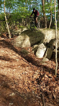
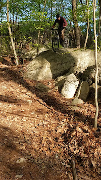
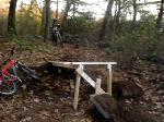
Photos of Needham Town Forest Mountain Bike
Videos of Needham Town Forest Mountain Bike
trail: Broken Toe
0:24 |
363 |
May 14, 2021
trail: Broken Toe
0:12 |
297 |
May 13, 2021
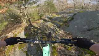
trail: Tape Worm
16:52 |
262 |
Feb 14, 2024 , Needham
trail: Drop-Off
0:08 |
356 |
Jan 1, 2008

689 |
Nov 2, 2016
Recent Trail Reports
| status | trail | date | condition | info | user |
|---|---|---|---|---|---|
| Tape Worm | Jun 5, 2026 @ 5:51pm (America/New_York) Jun 5, 2026 | Unknown | Jeffersonpj8C7P | ||
| Unnamed Trail - Railroad connector | Jun 2, 2026 @ 6:53pm (America/New_York) Jun 2, 2026 | Unknown | SharonUqVlOs | ||
| Broken Toe | Apr 13, 2026 @ 9:55am (America/New_York) Apr 13, 2026 | Unknown | Jeffersonpj8C7P | ||
| Peak to Creek | Nov 16, 2025 @ 4:44pm (America/New_York) Nov 16, 2025 | Ideal | Bigem14 | ||
| To The Pond | Sep 9, 2025 @ 4:33pm (America/New_York) Sep 9, 2025 | Variable | mreiter1 | ||
| To the Pond | Jul 7, 2025 @ 7:12am Jul 7, 2025 | Variable | mcourc | ||
| Sudbury Path (Sudbury Aqueduct) | Mar 10, 2025 @ 3:07pm Mar 10, 2025 | Variable | snarlymarley | ||
| Unnamed Trail - Trail intersection 10+20+19 | Jan 17, 2025 @ 1:46pm Jan 17, 2025 | Variable | Tuffmofo | ||
| Rollercoaster | Nov 15, 2024 @ 9:29am Nov 15, 2024 | Dry | bjacokes | ||
| Earth Worm | Apr 16, 2023 @ 12:58pm Apr 16, 2023 | Ideal | rt7085 |
Activity Feed
| username | action | type | title | date |
|---|---|---|---|---|
| andresj77 | wishlist | route | activity #97241666 | Jun 18, 2026 @ 3:55am 3 days |
| Jeffersonpj8C7P | add | report | activity #96322777 | Jun 5, 2026 @ 2:51pm Jun 5, 2026 |
| ReinholdqP9Ulh | wishlist | trail | activity #96240359 | Jun 4, 2026 @ 11:03am Jun 4, 2026 |
| SharonUqVlOs | add | report | activity #96115090 | Jun 2, 2026 @ 3:53pm Jun 2, 2026 |
| abrocket | wishlist | route | activity #94748217 | May 15, 2026 @ 7:02am May 15, 2026 |
Recent Comments
| username | type | title | comment | date |
|---|---|---|---|---|
| report | Running well, no major problems from winter... | Apr 13, 2026 @ 6:55am Apr 13, 2026 | ||
| trail | The “popular route” to take roller coaster... | Aug 8, 2025 @ 8:37am Aug 8, 2025 | ||
| report | Still there | Jul 10, 2024 @ 3:36pm Jul 10, 2024 | ||
| trail | Why is this now a separate trail from the... | Jun 17, 2024 @ 6:04am Jun 17, 2024 | ||
| trail | NTF is full of great tech. When I lived in MA... | Nov 29, 2022 @ 2:14pm Nov 29, 2022 |
Nearby Areas
| name | distance | ||||
|---|---|---|---|---|---|
| Hale Education | 34 | 29 | 22 | 2 | 2.6 km |
| Cutler Park | 16 | 22 | 3 | 2.6 km | |
| Noanet Woodlands | 36 | 10 | 1 | 2.6 km | |
| Elm Bank Reservation | 7 | 2.9 km | |||
| Stone Conservation Area | 1 | 3.2 km |
Local Badges
-

Completionist12 awarded
Activity Type Stats
| activitytype | trails | distance | descent | descent distance | total vertical | rating | global rank | state rank | photos | reports | routes | ridelogs |
|---|---|---|---|---|---|---|---|---|---|---|---|---|
| Mountain Bike | 26 | 15 miles | 886 ft | 5 miles | 148 ft | #4,079 | #1,426 | 44 | 180 | 2 | 9,233 | |
| Hike | 26 | 15 miles | 886 ft | 5 miles | 148 ft | #9,770 | #3,784 | 1 | 180 | 113 | ||
| Trail Running | 26 | 15 miles | 886 ft | 5 miles | 148 ft | #8,697 | #3,070 | 180 | 342 | |||
| Snowshoe | 1 | 2 miles | 59 ft | 1 | ||||||||
| Nordic Ski | 1 | 2 miles | 59 ft |
Frequently Asked Questions About Needham Town Forest
▼
What are the highest rated mountain biking trails in Needham Town Forest?
The highest rated mountain biking trails in Needham Town Forest are:
- Broken Toe (4.2/5)
- Rollercoaster (4.2/5)
- Tape Worm (4.1/5)
- Stranger Danger (4.1/5)
- Peak to Creek (4/5)
▼
What is the best time of the year to ride in Needham Town Forest?
Based on ride log data, the most popular months to ride in Needham Town Forest are:
- May (184 activities)
- September (161 activities)
- June (144 activities)
▼
Where can I park to ride in Needham Town Forest?
There are 3 parking locations listed in Needham Town Forest. The most popular parking spots are: View all parking and trailhead locations on the map to plan your visit.
▼
What is the longest trail in Needham Town Forest?
The longest trail in Needham Town Forest is Rollercoaster at 2.3 miles. View all trails sorted by distance.
Activities
Trails
Points of Interest
- By tbubier
 & contributors
 - Admins: apply
- #5730 - 12,971 views
- needham town forest activity log | embed map of Needham Town Forest mountain bike trails | needham town forest mountain biking points of interest
Downloading of trail gps tracks in kml & gpx formats is enabled for Needham Town Forest.
You must login to download files.