close
-
Layers w
- Weather Layers
- Pro
- Pro
- Pro
- Pro
- Pro
- Pro
- More Layers
- Pro
- Pro
- Pro
- Pro
-
Upgrade to

3D
Trail Conditions
- Unknown
- Snow Groomed
- Snow Packed
- Snow Covered
- Snow Cover Partial
- Freeze/thaw Cycle
- Icy
- Prevalent Mud
- Wet
- Variable
- Ideal
- Dry
- Very Dry
Trail Flow (Ridden Direction)
Trailforks scans users ridelogs to determine the most popular direction each trail is ridden. A good flowing trail network will have most trails flowing in a single direction according to their intension.
The colour categories are based on what percentage of riders are riding a trail in its intended direction.
The colour categories are based on what percentage of riders are riding a trail in its intended direction.
- > 96%
- > 90%
- > 80%
- > 70%
- > 50%
- < 50%
- bi-directional trail
- no data
Trail Last Ridden
Trailforks scans ridelogs to determine the last time a trail was ridden.
- < 2 days
- < 1 week
- < 2 weeks
- < 1 month
- < 6 months
- > 6 months
Trail Ridden Direction
The intended direction a trail should be ridden.
- Downhill Only
- Downhill Primary
- Both Directions
- Uphill Primary
- Uphill Only
- One Direction
Contribute Details
Colors indicate trail is missing specified detail.
- Description
- Photos
- Description & Photos
- Videos
Trail Popularity ?
Trailforks scans ridelogs to determine which trails are ridden the most in the last 9 months.
Trails are compared with nearby trails in the same city region with a possible 25 colour shades.
Think of this as a heatmap, more rides = more kinetic energy = warmer colors.
- most popular
- popular
- less popular
- not popular
ATV/ORV/OHV Filter
Max Vehicle Width
inches
US Cell Coverage
Legend

Radar Time
Activity Recordings
Trailforks uses anonymized public activity data.
?
Activity Recordings
Trailforks uses anonymized public activity data.
?
Personal Heatmap
▶
Activity Types
all
/
none
▶
Options
2
Date range
month
–
Winter Trails
Warning
A routing network for winter maps does not exist. Selecting trails using the winter trails layer has been disabled.
Missing Trails
Most Popular
Least Popular
Trails are colored based on popularity. The more popular a trail is, the more red. Less popular trails trend towards green.
Jump Magnitude Heatmap
Heatmap of where riders jump on trails. Zoom in to see individual jumps, click circles to view jump details.
BC Backroad Status
![map legend]()
Service Road Atlas is a free to use, community-driven service for viewing and creating reports on the numerous back-country service roads around B.C. and Alberta.

Slope Aspect
Direction the slope faces
Trails Deemphasized
Trails are shown in grey.
Only show trails with no bike usage.
Suggested Layers
Based on selected activity type
Save the current map location and zoom level as your default home location whenever this page is loaded.
Save
No description for Neilston has been added yet!
Login or register to submit one.
This region uses the Uk/Euro style trail grading system.
Activities Click to view
- Mountain Bike
7 trails
- E-Bike
7 trails
- Adaptive Bike
0 trails
- Hike
6 trails
- Trail Running
6 trails
Region Details
- 2
- 4
- 1
Region Status
Caution as of Mar 6, 2025Local Trail Association
Stats
- Avg Trail Rating
- Trails (view details)
- 7
- Trails Mountain Bike
- 7
- Trails E-Bike
- 7
- Trails Hike
- 6
- Trails Trail Running
- 6
- Total Distance
- 2 miles
- Total Descent Distance
- 1 mile
- Total Descent
- 537 ft
- Total Vertical
- 153 ft
- Highest Trailhead
- 778 ft
- Reports
- 7
- Photos
- 1
- Ridden Counter
- 165
Popular Neilston Mountain Biking Trails
• 45 ★ 2.5 • 1,243 ft • 3 ft • 18 •
Straight forward trail through the woods, a couple of jumps, one small gap and a few small step downs
• 30 ★ 3.0 • 1,335 ft • 0 ft • 15 •
Less popular red difficulty singletrack. This mountain bike primary trail can be used downhill primary. On average it takes 8 minutes to complete this trail.
Videos of Neilston Mountain Bike
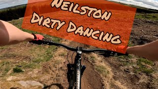
trail: Dirty Dancing
0:14 |
686 |
Oct 3, 2020 , Neilston
Recent Trail Reports
| status | trail | date | condition | info | user |
|---|---|---|---|---|---|
| Incoming | Nov 1, 2020 @ 3:29am Nov 1, 2020 | Wet | Altooze | ||
| Dirty Dancing | Nov 1, 2020 @ 3:29am Nov 1, 2020 | Wet | Altooze | ||
| Evergreen lane | Nov 1, 2020 @ 3:29am Nov 1, 2020 | Variable | Altooze | ||
| Get out | Nov 1, 2020 @ 3:29am Nov 1, 2020 | Variable | Altooze |
Activity Feed
| username | action | type | title | date |
|---|---|---|---|---|
| CamRivers | add | report | activity #67271309 | Mar 6, 2025 @ 5:20am Mar 6, 2025 |
| CamRivers | comment | trail | activity #67271261 and 1 more | Mar 6, 2025 @ 5:19am Mar 6, 2025 |
| CamRivers | vote | trail | activity #67271228 and 4 more | Mar 6, 2025 @ 5:18am Mar 6, 2025 |
| jmc78 | ridden | trail | activity #54322755 and 1 more | Jun 18, 2024 @ 8:12am Jun 18, 2024 |
| mac-73 | wishlist | trail | activity #17337691 and 5 more | Mar 17, 2021 @ 4:03am Mar 17, 2021 |
Recent Comments
| username | type | title | comment | date |
|---|---|---|---|---|
| trail | Ok wee trail. Couple of nice moves. Not really... | Mar 6, 2025 @ 5:22am Mar 6, 2025 | ||
| trail | All these blue "trails" are just brashed... | Mar 6, 2025 @ 5:19am Mar 6, 2025 |
Activity Type Stats
| activitytype | trails | distance | descent | descent distance | total vertical | rating | global rank | state rank | photos | reports | routes | ridelogs |
|---|---|---|---|---|---|---|---|---|---|---|---|---|
| Mountain Bike | 7 | 2 miles | 538 ft | 1 mile | 154 ft | #11,538 | #442 | 1 | 7 | 646 | ||
| E-Bike | 7 | 2 miles | 538 ft | 1 mile | 154 ft | #8,413 | #380 | 5 | 194 | |||
| Hike | 6 | 1 mile | 394 ft | 1 mile | 128 ft | #13,235 | #495 | 7 | 8 | |||
| Trail Running | 6 | 1 mile | 394 ft | 1 mile | 128 ft | #12,715 | #482 | 7 | 32 |
Frequently Asked Questions About Neilston
▼
What are the highest rated mountain biking trails in Neilston?
The highest rated mountain biking trails in Neilston are:
- Get out (4/5)
- Evergreen lane (0/5)
- Plain jane (0/5)
- Dirty Dancing (0/5)
- Mack's Track DH (0/5)
▼
What is the best time of the year to ride in Neilston?
Based on ride log data, the most popular months to ride in Neilston are:
- July (5 activities)
- February (2 activities)
- August (1 activities)
▼
Where can I park to ride in Neilston?
Check the Neilston trail map for trailhead and parking information. Community members regularly update access and parking details for trails in the area.
▼
What is the longest trail in Neilston?
The longest trail in Neilston is Dirty Dancing at 1,335 ft. View all trails sorted by distance.
- By Brokenmtb & contributors
- Admins: DMBinS, FLS, RMTBC
- #26396 - 2,135 views
- neilston activity log | embed map of Neilston mountain bike trails |
Downloading of trail gps tracks in kml & gpx formats is enabled for Neilston.
You must login to download files.