close
-
Layers w
- Weather Layers
- Pro
- Pro
- Pro
- Pro
- Pro
- Pro
- More Layers
- Pro
- Pro
- Pro
- Pro
-
Upgrade to

3D
Trail Conditions
- Unknown
- Snow Groomed
- Snow Packed
- Snow Covered
- Snow Cover Partial
- Freeze/thaw Cycle
- Icy
- Prevalent Mud
- Wet
- Variable
- Ideal
- Dry
- Very Dry
Trail Flow (Ridden Direction)
Trailforks scans users ridelogs to determine the most popular direction each trail is ridden. A good flowing trail network will have most trails flowing in a single direction according to their intension.
The colour categories are based on what percentage of riders are riding a trail in its intended direction.
The colour categories are based on what percentage of riders are riding a trail in its intended direction.
- > 96%
- > 90%
- > 80%
- > 70%
- > 50%
- < 50%
- bi-directional trail
- no data
Trail Last Ridden
Trailforks scans ridelogs to determine the last time a trail was ridden.
- < 2 days
- < 1 week
- < 2 weeks
- < 1 month
- < 6 months
- > 6 months
Trail Ridden Direction
The intended direction a trail should be ridden.
- Downhill Only
- Downhill Primary
- Both Directions
- Uphill Primary
- Uphill Only
- One Direction
Contribute Details
Colors indicate trail is missing specified detail.
- Description
- Photos
- Description & Photos
- Videos
Trail Popularity ?
Trailforks scans ridelogs to determine which trails are ridden the most in the last 9 months.
Trails are compared with nearby trails in the same city region with a possible 25 colour shades.
Think of this as a heatmap, more rides = more kinetic energy = warmer colors.
- most popular
- popular
- less popular
- not popular
ATV/ORV/OHV Filter
Max Vehicle Width
inches
US Cell Coverage
Legend

Radar Time
Activity Recordings
Trailforks uses anonymized public activity data.
?
Activity Recordings
Trailforks uses anonymized public activity data.
?
Personal Heatmap
▶
Activity Types
all
/
none
▶
Options
2
Date range
month
–
Winter Trails
Warning
A routing network for winter maps does not exist. Selecting trails using the winter trails layer has been disabled.
Missing Trails
Most Popular
Least Popular
Trails are colored based on popularity. The more popular a trail is, the more red. Less popular trails trend towards green.
Jump Magnitude Heatmap
Heatmap of where riders jump on trails. Zoom in to see individual jumps, click circles to view jump details.
BC Backroad Status
![map legend]()
Service Road Atlas is a free to use, community-driven service for viewing and creating reports on the numerous back-country service roads around B.C. and Alberta.

Slope Aspect
Direction the slope faces
Trails Deemphasized
Trails are shown in grey.
Only show trails with no bike usage.
Suggested Layers
Based on selected activity type
Save the current map location and zoom level as your default home location whenever this page is loaded.
Save
No description for Neosho has been added yet!
Login or register to submit one.
Activities Click to view
- Mountain Bike
20 trails
- E-Bike
12 trails
- Horse
8 trails
- Hike
20 trails
- Trail Running
20 trails
Region Details
- 1
- 1
- 7
- 4
- 1
Region Status
Caution as of May 8, 2026Stats
- Avg Trail Rating
- Trails (view details)
- 14
- Trails Mountain Bike
- 20
- Trails E-Bike
- 12
- Trails Horse
- 8
- Trails Hike
- 20
- Trails Trail Running
- 20
- Total Distance
- 17 miles
- Total Descent
- 1,600 ft
- Total Vertical
- 269 ft
- Highest Trailhead
- 1,260 ft
- Reports
- 62
- Photos
- 12
- Ridden Counter
- 279
Sub Regions
-
Bicentenial Conservation Area
- 1
- 3
-
Morse Park
- 1
-
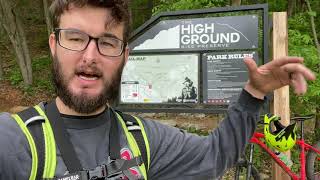
The High Ground Bike Preserve
- 5
- 2
- 1
Popular Neosho Mountain Biking Trails
• 100 ★ 4.0 • 3 miles • 307 ft • 66 •
Popular green difficulty family friendly singletrack. This multi-use trail can be used both directions and has a moderate overall physical rating with a 307 ft green climb. Trail visibility is always easy to follow. On average it takes 29 minutes to complete this trail.
• 95 ★ 4.0 • 2 miles • 78 ft • 46 •
Popular green difficulty family friendly singletrack. This multi-use trail can be used both directions and has a easy overall physical rating with a 78 ft blue climb. It features log ride and other. Trail visibility is always easy to follow. On average it takes 11 minutes to complete this trail.
• 85 ★ 3.5 • 3,839 ft • 0 ft • 25 •
Popular green difficulty singletrack. This multi-use trail can be used one direction and has a easy overall physical rating. Trail visibility is always easy to follow. On average it takes 6 minutes to complete this trail.
• 80 ★ 0.0 • 364 ft • 9 ft • 23 •
Popular green difficulty singletrack. This multi-use trail can be used both directions and has a easy overall physical rating with a 9 ft green climb. Trail visibility is always easy to follow.
• 90 ★ 3.5 • 1,473 ft • 0 ft • 22 •
Popular blue difficulty singletrack. This multi-use trail can be used one direction and has a moderate overall physical rating. Trail visibility is always easy to follow. On average it takes minutes to complete this trail.
• 70 ★ 0.0 • 1,722 ft • 3 ft • 14 •
Popular black diamond difficulty singletrack. This multi-use trail can be used one direction and has a hard overall physical rating.
• 75 ★ 0.0 • 1,112 ft • 5 ft • 10 •
Popular white difficulty paved path. This multi-use trail can be used both directions and has a easy overall physical rating with a 5 ft green climb. On average it takes 1 minutes to complete this trail.
• 60 ★ 0.0 • 335 ft • 0 ft • 6 •
Moderately popular green difficulty singletrack. This multi-use trail can be used both directions and has a easy overall physical rating with a 0 ft green climb. Trail visibility is always easy to follow.
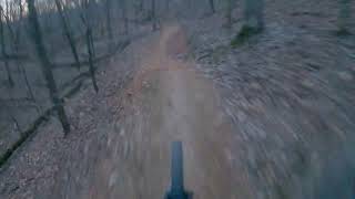
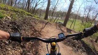
Videos of Neosho Mountain Bike
2:01 |
125 |
Jan 5, 2024
trail: Rough Rider Ridge
13:09 |
226 |
Jan 5, 2024 , Neosho

trail: Wildcat Chase
7:04 |
180 |
Jan 5, 2024 , Neosho
trail: Rough Rider Ridge
11:24 |
307 |
May 17, 2021 , Neosho

trail: Rough Rider Ridge
5:26 |
1107 |
Mar 30, 2021 , Neosho
Recent Trail Reports
| status | trail | date | condition | info | user |
|---|---|---|---|---|---|
| Lazy Boy | May 7, 2026 @ 6:49pm (America/Chicago) May 7, 2026 | Unknown | teamwalters2000 MVMBA | ||
| Wildcat Chase | May 7, 2026 @ 6:13pm (America/Chicago) May 7, 2026 | Unknown | teamwalters2000 MVMBA | ||
| Rough Rider Ridge | May 7, 2026 @ 6:06pm (America/Chicago) May 7, 2026 | Unknown | teamwalters2000 MVMBA | ||
| Homestead | Feb 15, 2026 @ 2:42pm (America/Indiana/Vincennes) Feb 15, 2026 | Ideal | thomcerny NGMBA | ||
| Doniphan Dr Trailhead Parking | Feb 15, 2026 @ 2:01pm (America/Indiana/Vincennes) Feb 15, 2026 | Ideal | thomcerny NGMBA | ||
| The Lowgrounds | Jan 5, 2024 @ 5:04pm Jan 5, 2024 | Ideal | WillieJacobsz Trailforks | ||
| Parking Area | Jan 5, 2024 @ 5:04pm Jan 5, 2024 | Ideal | WillieJacobsz Trailforks | ||
| Gone Rogue | Jan 5, 2024 @ 5:04pm Jan 5, 2024 | Ideal | WillieJacobsz Trailforks | ||
| Access Trail - out | Jan 5, 2024 @ 5:04pm Jan 5, 2024 | Ideal | WillieJacobsz Trailforks | ||
| Access Trail - In | Jan 5, 2024 @ 5:04pm Jan 5, 2024 | Ideal | WillieJacobsz Trailforks |
Activity Feed
| username | action | type | title | date |
|---|---|---|---|---|
| NathanKen | ridden | trail | activity #97353387 | Jun 19, 2026 @ 4:43pm 49 mins |
| NathanKen | ridden | trail | activity #97353362 and 3 more | Jun 19, 2026 @ 4:43pm 49 mins |
| NathanKen | ridden | trail | activity #97353260 and 1 more | Jun 19, 2026 @ 4:41pm 51 mins |
| teamwalters2000 | add | report | activity #94247527 and 3 more | May 7, 2026 @ 4:06pm May 7, 2026 |
| p90k3x | ridden | trail | activity #91036476 and 1 more | Mar 21, 2026 @ 4:50pm Mar 21, 2026 |
Recent Comments
| username | type | title | comment | date |
|---|---|---|---|---|
| trail | Lack of maintenance has made this system... | Feb 15, 2026 @ 3:35pm Feb 15, 2026 | ||
| trail | Lack of maintenance has made this system... | Feb 15, 2026 @ 3:35pm Feb 15, 2026 | ||
| trail | Lack of maintenance has made this system... | Feb 15, 2026 @ 3:34pm Feb 15, 2026 | ||
| trail | Lack of maintenance has made this system... | Feb 15, 2026 @ 3:33pm Feb 15, 2026 | ||
| trail | Fun trail. Really pretty fast. With a couple... | Sep 29, 2025 @ 10:36am Sep 29, 2025 |
Local Badges
-

Epic Mountain Bike Climb 2k0 awarded -

Climbing 10k Badge0 awarded -

Mountain Biking 100k Badge0 awarded -

Epic Ride Descent 2k0 awarded -

Descent 10k Badge0 awarded -

Descent 100k Badge0 awarded
Activity Type Stats
| activitytype | trails | distance | descent | descent distance | total vertical | rating | global rank | state rank | photos | reports | routes | ridelogs |
|---|---|---|---|---|---|---|---|---|---|---|---|---|
| Mountain Bike | 20 | 17 miles | 1,601 ft | 6 miles | 269 ft | #10,137 | #3,172 | 9 | 62 | 1,660 | ||
| E-Bike | 12 | 8 miles | 1,020 ft | 3 miles | 220 ft | #7,683 | #2,322 | 3 | 50 | 22 | ||
| Horse | 8 | 4 miles | 184 ft | 1 mile | 243 ft | #3,150 | #1,795 | 9 | ||||
| Hike | 20 | 17 miles | 1,601 ft | 6 miles | 269 ft | #9,147 | #3,219 | 62 | 66 | |||
| Trail Running | 20 | 17 miles | 1,601 ft | 6 miles | 269 ft | #8,674 | #2,903 | 62 | 33 |
Frequently Asked Questions About Neosho
▼
What are the best places to ride in Neosho?
Neosho has 3 areas to explore for mountain biking. The top rated areas are:
▼
What are the highest rated mountain biking trails in Neosho?
The highest rated mountain biking trails in Neosho are:
- Rough Rider Ridge (4/5)
- Homestead (4/5)
- Lazy Boy (3.9/5)
- Wildcat Chase (3.9/5)
- Bike Path (0/5)
▼
What is the best time of the year to ride in Neosho?
Based on ride log data, the most popular months to ride in Neosho are:
- July (9 activities)
- October (8 activities)
- April (7 activities)
▼
Where can I park to ride in Neosho?
There are 3 parking locations listed in Neosho. The most popular parking spots are: View all parking and trailhead locations on the map to plan your visit.
Activities
Trails
Points of Interest
- By todd
 Trailforks & contributors
 - Admins: MDC-SW, thomcerny
- #28641 - 3,737 views
- neosho activity log | embed map of Neosho mountain bike trails | neosho mountain biking points of interest
Downloading of trail gps tracks in kml & gpx formats is enabled for Neosho.
You must login to download files.