close
-
Layers w
- Weather Layers
- Pro
- Pro
- Pro
- Pro
- Pro
- Pro
- More Layers
- Pro
- Pro
- Pro
- Pro
-
Upgrade to

3D
Trail Conditions
- Unknown
- Snow Groomed
- Snow Packed
- Snow Covered
- Snow Cover Partial
- Freeze/thaw Cycle
- Icy
- Prevalent Mud
- Wet
- Variable
- Ideal
- Dry
- Very Dry
Trail Flow (Ridden Direction)
Trailforks scans users ridelogs to determine the most popular direction each trail is ridden. A good flowing trail network will have most trails flowing in a single direction according to their intension.
The colour categories are based on what percentage of riders are riding a trail in its intended direction.
The colour categories are based on what percentage of riders are riding a trail in its intended direction.
- > 96%
- > 90%
- > 80%
- > 70%
- > 50%
- < 50%
- bi-directional trail
- no data
Trail Last Ridden
Trailforks scans ridelogs to determine the last time a trail was ridden.
- < 2 days
- < 1 week
- < 2 weeks
- < 1 month
- < 6 months
- > 6 months
Trail Ridden Direction
The intended direction a trail should be ridden.
- Downhill Only
- Downhill Primary
- Both Directions
- Uphill Primary
- Uphill Only
- One Direction
Contribute Details
Colors indicate trail is missing specified detail.
- Description
- Photos
- Description & Photos
- Videos
Trail Popularity ?
Trailforks scans ridelogs to determine which trails are ridden the most in the last 9 months.
Trails are compared with nearby trails in the same city region with a possible 25 colour shades.
Think of this as a heatmap, more rides = more kinetic energy = warmer colors.
- most popular
- popular
- less popular
- not popular
ATV/ORV/OHV Filter
Max Vehicle Width
inches
US Cell Coverage
Legend

Radar Time
Activity Recordings
Trailforks uses anonymized public activity data.
?
Activity Recordings
Trailforks uses anonymized public activity data.
?
Personal Heatmap
▶
Activity Types
all
/
none
▶
Options
2
Date range
month
–
Winter Trails
Warning
A routing network for winter maps does not exist. Selecting trails using the winter trails layer has been disabled.
Missing Trails
Most Popular
Least Popular
Trails are colored based on popularity. The more popular a trail is, the more red. Less popular trails trend towards green.
Jump Magnitude Heatmap
Heatmap of where riders jump on trails. Zoom in to see individual jumps, click circles to view jump details.
BC Backroad Status
![map legend]()
Service Road Atlas is a free to use, community-driven service for viewing and creating reports on the numerous back-country service roads around B.C. and Alberta.

Slope Aspect
Direction the slope faces
Trails Deemphasized
Trails are shown in grey.
Only show trails with no bike usage.
Suggested Layers
Based on selected activity type
Save the current map location and zoom level as your default home location whenever this page is loaded.
SaveParque Natural de Sierras de Tejeda, Almijara y Alhama.
This region uses the Uk/Euro style trail grading system.
Activities Click to view
- Mountain Bike
189 trails
- E-Bike
176 trails
- Adaptive Bike
0 trails
- Hike
191 trails
- Trail Running
191 trails
Region Details
- 73
- 18
- 51
- 29
- 7
Region Status
Caution as of Apr 26, 2026Stats
- Avg Trail Rating
- Trails (view details)
- 179
- Trails Mountain Bike
- 189
- Trails E-Bike
- 176
- Trails Gravel Bike
- 1
- Trails Horse
- 2
- Trails Hike
- 191
- Trails Trail Running
- 191
- Total Distance
- 106 miles
- Total Descent
- 31,166 ft
- Total Vertical
- 6,534 ft
- Highest Trailhead
- 6,755 ft
- Reports
- 75
- Photos
- 32
- Ridden Counter
- 1,175
Sub Regions
-
Parque Natural de Sierras de Tejeda, Almijara y Alhama.
- 7
- 38
- 25
- 6
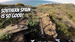
Popular Nerja Mountain Biking Trails
• 85 ★ 3.4 • 2 miles • 0 ft • 23 •
Popular blue difficulty singletrack. This multi-use trail can be used downhill only and has a hard overall physical rating with a 0 ft blue climb. It features drop and rock face. On average it takes 48 minutes to complete this trail.
• 100 ★ 5.0 • 2 miles • 0 ft • 21 •
Sendero fácil en cañón. Sólo es difícil al principio al descender al cañón y a mitad del camino. Totalmente manejable, pero es posible que un principiante necesite bajarse de la bicicleta. Easy trail in canyon. Only difficult in...
• 100 ★ 5.0 • 1 mile • 3 ft • 20 •
Bajada perteneciente en su día creo que a la copa andaluza. Para mi nivel tiene algún paso complicado que requiere de un mínimo. Comienza en la misma zona que la denominada 2.
• 95 ★ 5.0 • 2,421 ft • 62 ft • 9 •
Popular green difficulty singletrack. This multi-use trail can be used both directions and has a moderate overall physical rating with a 62 ft blue climb. Trail visibility is always easy to follow. On average it takes 2 minutes to complete this trail.
• 80 ★ 1.0 • 1 mile • 0 ft • 7 •
Subida por pista hasta zona de inicio de bajada, en la misma localización hay dos senderos. Este segundo que considero azul con pendiente vertical considerable en algún tramo y mucha piedra suelta.
• 5 ★ 5.0 • 2 miles • 406 ft • 5 •
Less popular blue difficulty singletrack. This multi-use trail can be used both directions and has a moderate overall physical rating with a 406 ft blue climb. Trail visibility is always easy to follow. On average it takes 36 minutes to complete this trail.
• 95 ★ 0.0 • 203 ft • 0 ft • 5 •
Popular blue difficulty singletrack. This multi-use trail can be used downhill primary. It features rock garden. Trail visibility is always easy to follow.
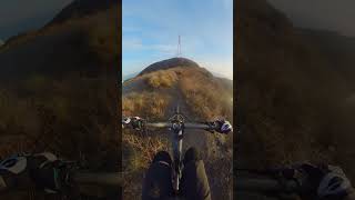
Nerja Mountain Bike Routes
★ 1.0 • 15 miles • 2,199 ft • 0 • Out & Back •
Start in Nerja and climbs quickly to El Pinarillo, Fuente del Esparto and Collado de los Apretaderos....
21 miles • 5,380 ft • 0 • Point to Point •
Ruta Canillas de Albaida - Sedella
Photos of Nerja Mountain Bike
Recent Trail Reports
| status | trail | date | condition | info | user |
|---|---|---|---|---|---|
| Cerro Pastora Easy Middle | Apr 26, 2026 @ 5:45pm (Europe/Madrid) Apr 26, 2026 | Unknown | ErikITjofo | ||
| Cerro Pastora | Apr 26, 2026 @ 5:45pm (Europe/Madrid) Apr 26, 2026 | Unknown | ErikITjofo | ||
| Cerro Pastora Lower | Apr 26, 2026 @ 5:43pm (Europe/Madrid) Apr 26, 2026 | Unknown | ErikITjofo | ||
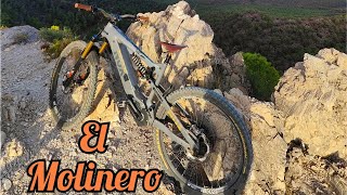
| Molinero | Jan 12, 2026 @ 10:55am (Europe/Madrid) Jan 12, 2026 | Ideal | MalagaRider | ||
| Acceso Cuesta del Cielo | Jan 12, 2026 @ 10:55am (Europe/Madrid) Jan 12, 2026 | Ideal | MalagaRider | ||
| Los Colmenarejos | Jan 10, 2026 @ 12:30pm (Europe/Madrid) Jan 10, 2026 | Unknown | ErikITjofo | ||
| Acceso Mirador Tajo de los Bueyes | Jan 10, 2026 @ 12:30pm (Europe/Madrid) Jan 10, 2026 | Unknown | ErikITjofo | ||
| Puerto De Competa | Dec 24, 2025 @ 11:10am (Europe/Madrid) Dec 24, 2025 | Unknown | ErikITjofo | ||
| Maro Segunda Salida | Dec 15, 2025 @ 2:07pm (Europe/Madrid) Dec 15, 2025 | Unknown | ErikITjofo | ||
| Maro River Rumble | Dec 15, 2025 @ 2:06pm (Europe/Madrid) Dec 15, 2025 | Unknown | ErikITjofo |
Activity Feed
| username | action | type | title | date |
|---|---|---|---|---|
| MarkTL | ridden | trail | activity #96798019 | Jun 12, 2026 @ 6:03am Jun 12, 2026 |
| Angelreing | update | trail | activity #94007096 and 2 more | May 3, 2026 @ 10:27pm May 3, 2026 |
| ErikITjofo | add | trail | activity #94007081 and 1 more | May 3, 2026 @ 10:26pm May 3, 2026 |
| ErikITjofo | add | report | activity #93447157 and 2 more | Apr 26, 2026 @ 8:44am Apr 26, 2026 |
| ErikITjofo | add | trail | activity #92135481 | Apr 7, 2026 @ 12:34pm Apr 7, 2026 |
Recent Comments
| username | type | title | comment | date |
|---|---|---|---|---|
| trail | Fait le 8 janvier 2026 avec mon épouse . Elle... | Jan 10, 2026 @ 7:45am Jan 10, 2026 | ||
| trail | Lower part full of fallen trees. Needs trial... | Dec 25, 2025 @ 6:38am Dec 25, 2025 | ||
| trail | Really not funny, at the bottom section lots... | Dec 25, 2025 @ 6:35am Dec 25, 2025 | ||
| trail | Not flowy or a rythm at all. At the beginning... | Jan 26, 2025 @ 9:04am Jan 26, 2025 | ||
| trail | Linha com bastante pedras, mas muito divertida... | Nov 8, 2023 @ 11:49am Nov 8, 2023 |
Local Badges
-

Completionist0 awarded -

Epic Mountain Bike Climb 2k5 awarded -

Climbing 10k Badge1 awarded -

Mountain Biking 100k Badge0 awarded -

Epic Ride Descent 2k5 awarded -

Descent 10k Badge1 awarded
Activity Type Stats
| activitytype | trails | distance | descent | descent distance | total vertical | rating | global rank | state rank | photos | reports | routes | ridelogs |
|---|---|---|---|---|---|---|---|---|---|---|---|---|
| Mountain Bike | 189 | 104 miles | 31,109 ft | 51 miles | 6,535 ft | #1,647 | #156 | 26 | 75 | 2 | 4,863 | |
| E-Bike | 176 | 98 miles | 29,603 ft | 49 miles | 6,532 ft | #928 | #215 | 5 | 74 | 1 | 666 | |
| Gravel Bike | 1 | #5,407 | #231 | 119 | ||||||||
| Horse | 2 | |||||||||||
| Hike | 191 | 106 miles | 31,165 ft | 51 miles | 6,535 ft | #1,337 | #150 | 75 | 736 | |||
| Trail Running | 191 | 106 miles | 31,165 ft | 51 miles | 6,535 ft | #1,027 | #150 | 75 | 131 |
Frequently Asked Questions About Nerja
▼
What are the best places to ride in Nerja?
Nerja has 1 areas to explore for mountain biking. The top rated areas are:
▼
What are the highest rated mountain biking trails in Nerja?
The highest rated mountain biking trails in Nerja are:
- Calaceite (4.2/5)
- Monte Cielo (Media Luna) (4.2/5)
- Los Colmenarejos (4.1/5)
- Cerro Pastora (4.1/5)
- Cerro Pastora Easy Middle (4.1/5)
▼
What is the best time of the year to ride in Nerja?
Based on ride log data, the most popular months to ride in Nerja are:
- October (23 activities)
- September (11 activities)
- November (11 activities)
▼
Where can I park to ride in Nerja?
Check the Nerja trail map for trailhead and parking information. Community members regularly update access and parking details for trails in the area.
Activities
Trails
Points of Interest
- By lightlives
 & contributors
 - Admins: AMG, juanx
- #8353 - 8,453 views
- nerja activity log | embed map of Nerja mountain bike trails | nerja mountain biking points of interest
Downloading of trail gps tracks in kml & gpx formats is enabled for Nerja.
You must login to download files.