close
-
Layers w
- Weather Layers
- Pro
- Pro
- Pro
- Pro
- Pro
- Pro
- More Layers
- Pro
- Pro
- Pro
- Pro
-
Upgrade to

3D
Trail Conditions
- Unknown
- Snow Groomed
- Snow Packed
- Snow Covered
- Snow Cover Partial
- Freeze/thaw Cycle
- Icy
- Prevalent Mud
- Wet
- Variable
- Ideal
- Dry
- Very Dry
Trail Flow (Ridden Direction)
Trailforks scans users ridelogs to determine the most popular direction each trail is ridden. A good flowing trail network will have most trails flowing in a single direction according to their intension.
The colour categories are based on what percentage of riders are riding a trail in its intended direction.
The colour categories are based on what percentage of riders are riding a trail in its intended direction.
- > 96%
- > 90%
- > 80%
- > 70%
- > 50%
- < 50%
- bi-directional trail
- no data
Trail Last Ridden
Trailforks scans ridelogs to determine the last time a trail was ridden.
- < 2 days
- < 1 week
- < 2 weeks
- < 1 month
- < 6 months
- > 6 months
Trail Ridden Direction
The intended direction a trail should be ridden.
- Downhill Only
- Downhill Primary
- Both Directions
- Uphill Primary
- Uphill Only
- One Direction
Contribute Details
Colors indicate trail is missing specified detail.
- Description
- Photos
- Description & Photos
- Videos
Trail Popularity ?
Trailforks scans ridelogs to determine which trails are ridden the most in the last 9 months.
Trails are compared with nearby trails in the same city region with a possible 25 colour shades.
Think of this as a heatmap, more rides = more kinetic energy = warmer colors.
- most popular
- popular
- less popular
- not popular
ATV/ORV/OHV Filter
Max Vehicle Width
inches
US Cell Coverage
Legend

Radar Time
Activity Recordings
Trailforks uses anonymized public activity data.
?
Activity Recordings
Trailforks uses anonymized public activity data.
?
Personal Heatmap
▶
Activity Types
all
/
none
▶
Options
2
Date range
month
–
Winter Trails
Warning
A routing network for winter maps does not exist. Selecting trails using the winter trails layer has been disabled.
Missing Trails
Most Popular
Least Popular
Trails are colored based on popularity. The more popular a trail is, the more red. Less popular trails trend towards green.
Jump Magnitude Heatmap
Heatmap of where riders jump on trails. Zoom in to see individual jumps, click circles to view jump details.
BC Backroad Status
![map legend]()
Service Road Atlas is a free to use, community-driven service for viewing and creating reports on the numerous back-country service roads around B.C. and Alberta.

Slope Aspect
Direction the slope faces
Trails Deemphasized
Trails are shown in grey.
Only show trails with no bike usage.
Suggested Layers
Based on selected activity type
Save the current map location and zoom level as your default home location whenever this page is loaded.
SaveForestry works in Leanachan Forest can have a significant effect on access to the wider Leanachan Forest. There may be disruption to forest access here with temporary closures and controlled timed access inevitable as operations progress. Please obey all signs and trail closures during any felling operations
Civil Engineering preparation works for harvesting operations may also cause significant disruption to visitors on the forest roads in this area. Again public access will be affected here with further temporary closures and controlled timed access on forest roads inevitable as civil works progress.
Civil Engineering preparation works for harvesting operations may also cause significant disruption to visitors on the forest roads in this area. Again public access will be affected here with further temporary closures and controlled timed access on forest roads inevitable as civil works progress.
Primary Trail Type: All-Mountain & Downhill
Land Status: Ski Resort
Land Manager: Forestry and Land Scotland
 google parking directions
This region uses the Uk/Euro style trail grading system.
Activities Click to view
- Mountain Bike
66 trails
- E-Bike
63 trails
- Horse
24 trails
- Hike
32 trails
- Trail Running
32 trails
Bike Park Details
- 25
- 7
- 11
- 21
- 2
Region Status
Open as of May 27, 2026- Day Ticket
- £40 GBP
- Uplift Type
- Gondola
- Season start
- Apr 3
- Season end
- Sep 14
Stats
- Avg Trail Rating
- Trails (view details)
- 66
- Trails Mountain Bike
- 66
- Trails E-Bike
- 63
- Trails Gravel Bike
- 20
- Trails Adaptive Bike
- 2
- Trails Winter Fat Bike
- 4
- Trails Horse
- 24
- Trails Hike
- 32
- Trails Trail Running
- 32
- Trails Downhill Ski
- 1
- Trails Backcountry Ski
- 1
- Total Distance
- 44 miles
- Total Descent
- 11,637 ft
- Total Vertical
- 2,168 ft
- Highest Trailhead
- 2,181 ft
- Reports
- 598
- Photos
- 4,250
- Ridden Counter
- 35,943
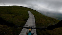
Popular Nevis Range Trails Mountain Biking Trails
• 95 ★ 4.6 • 2,008 ft • 0 ft • 3,232 •
Highly rated popular red difficulty singletrack. This mountain bike primary trail. Trail visibility is always easy to follow. On average it takes 1 minutes to complete this trail.
• 80 ★ 4.2 • 1 mile • 3 ft • 1,311 •
Board walk top section with fast sections and tight corners. Mid section along the ridge contains some board walk and natural bed rock with small features. Lower involves steep technical sections and an optional drop some technical bed...
• 100 ★ 4.0 • 4,606 ft • 184 ft • 1,231 •
Highly rated popular blue difficulty singletrack. This mountain bike primary trail can be used uphill only with a 184 ft blue climb. On average it takes 10 minutes to complete this trail.
• 95 ★ 3.9 • 3,219 ft • 0 ft • 1,140 •
NEW for 2014 - blue graded XC descent - Top section is fast with an 80m boardwalk (wide with chicken wire and gently bermed) followed by a flowing series of twists and turns. Finishes in the main Nevis Range car park. Accessed by a 2km...
• 100 ★ 5.0 • 1,339 ft • 9 ft • 1,112 •
Popular blue difficulty singletrack. This mountain bike primary trail and has a moderate overall physical rating with a 9 ft blue climb. It features berm. Trail visibility is always easy to follow. On average it takes 2 minutes to complete this trail.
• 90 ★ 4.8 • 2 miles • 2 ft • 1,085 •
Nevis Range Downhill ... the UK's ONLY OFFICIAL World Cup DH The Lowdown Times - uplift available 10.15am - 3.45pm Open - every day in the season other than certain race, maintenance & bad weather days Race day & maintenance...
• 70 ★ 4.7 • 2,159 ft • 0 ft • 998 •
Highly rated popular proline difficulty singletrack. This mountain bike primary trail can be used downhill only and has a easy overall physical rating with a 0 ft green climb. It features berm. On average it takes 3 minutes to complete this trail.
• 90 ★ 3.8 • 4,810 ft • 46 ft • 894 •
World Class single track specially devised for the 2007 World Championships held in Leanachan forest. The loop includes 270m of climb and descent.
Nevis Range Trails Mountain Bike Routes
19 miles • 2,714 ft • 3 • Loop •
Created this route to take you from the top of Nevis Range Gondola all the way out to the impressive sight...
5 miles • 812 ft • 39 • Loop •
Loop of , and Devil's Anus. All very fun blue trails suitable for all abilities, easily accessible from...
4 miles • 278 ft • 0 •
Bubbling around the River Lundy - a great trail to start. Plenty of flowing single track. This is the...
17 miles • 3,512 ft • 1 • Out & Back • Race •
2016 Fort William Scottish Enduro Series, http://scottishenduroseries.co.uk
★ 5.0 • 9 miles • 1,079 ft • 7 • Loop • Race •
This is the whole Witches Trail in Fort William.
Photos of Nevis Range Trails Mountain Bike
Videos of Nevis Range Trails Mountain Bike
trail: Top Chief
0:19 |
108 |
Jul 19, 2022

9:18 |
116 |
Jul 3, 2022

9:18 |
|
Jul 3, 2022
0:06 |
60 |
Dec 8, 2021

4:22 |
21 |
Jul 27, 2021

15:08 |
41 |
Jul 15, 2021
0:05 |
495 |
Jun 29, 2021
0:22 |
170 |
Jun 29, 2021
Recent Trail Reports
| status | trail | date | condition | info | user |
|---|---|---|---|---|---|
| Blue Adder | May 27, 2026 @ 11:48am (Europe/London) May 27, 2026 | Unknown | albamountainbike LTA | ||
| Stolen Bridge | May 23, 2026 @ 3:36pm (Europe/London) May 23, 2026 | Variable | KeironS LTA | ||
| Blue Doon | May 10, 2026 @ 8:47am (Europe/London) May 10, 2026 | Very Dry | KeironS LTA | ||
| Lazy K (Lower) | May 2, 2026 @ 3:53pm (Europe/London) May 2, 2026 | Dry | KeironS LTA | ||
| Fort William World Cup DH Track | Apr 30, 2026 @ 3:07pm (Europe/London) Apr 30, 2026 | Very Dry | KeironS LTA | ||
| Forest Road | Apr 24, 2026 @ 10:37am (Europe/Isle_of_Man) Apr 24, 2026 | Ideal | Dave-Haddow | ||
| 4X Track | Apr 24, 2026 @ 10:37am (Europe/Isle_of_Man) Apr 24, 2026 | Variable | Dave-Haddow | ||
| One Dot | Apr 24, 2026 @ 10:37am (Europe/Isle_of_Man) Apr 24, 2026 | Variable | Dave-Haddow | ||
| Wild Goat | Apr 24, 2026 @ 10:37am (Europe/Isle_of_Man) Apr 24, 2026 | Ideal | Dave-Haddow | ||
| Top Chief | Apr 24, 2026 @ 10:37am (Europe/Isle_of_Man) Apr 24, 2026 | Ideal | Dave-Haddow |
Activity Feed
| username | action | type | title | date |
|---|---|---|---|---|
| SashaWnxcmn | wishlist | trail | activity #96942651 | Jun 14, 2026 @ 12:38am Jun 14, 2026 |
| fwaring | wishlist | trail | activity #96811069 and 7 more | Jun 12, 2026 @ 9:42am Jun 12, 2026 |
| Kistler | ridden | trail | activity #96792907 and 1 more | Jun 12, 2026 @ 3:51am Jun 12, 2026 |
| zackxc | vote | trail | activity #96660864 | Jun 10, 2026 @ 3:04am Jun 10, 2026 |
| bilar | vote | trail | activity #95649461 | May 27, 2026 @ 11:32am May 27, 2026 |
Recent Comments
| username | type | title | comment | date |
|---|---|---|---|---|
| trail | Fun trail with one tricky uphill bit! | Sep 27, 2025 @ 5:01am Sep 27, 2025 | ||
| trail | Easy but fun black | Sep 27, 2025 @ 4:56am Sep 27, 2025 | ||
| trail | Fun trail through the trees! Not that... | Sep 27, 2025 @ 4:54am Sep 27, 2025 | ||
| trail | I don't think this is a black section TBH | Aug 23, 2025 @ 1:35pm Aug 23, 2025 | ||
| trail | Opening Mid April 2025 | Apr 4, 2025 @ 9:16am Apr 4, 2025 |
Nearby Areas
| name | distance | ||||
|---|---|---|---|---|---|
| Torlundy Trails | 1 | 2.1 km | |||
| Spean Bridge Trails | 4 | 1 | 4.1 km | ||
| Strone Trails | 1 | 4.8 km | |||
| Erracht Trails | 1 | 4.8 km | |||
| Fort William Trails | 2 | 1 | 4.8 km |
Local Badges
-

Completionist0 awarded
Bike & Skill Parks
| name | type | city | rating |
|---|---|---|---|
| Nevis Range Skillpark | skill park | Nevis Range |
Activity Type Stats
| activitytype | trails | distance | descent | descent distance | total vertical | rating | global rank | state rank | photos | reports | routes | ridelogs |
|---|---|---|---|---|---|---|---|---|---|---|---|---|
| Mountain Bike | 66 | 44 miles | 11,637 ft | 23 miles | 2,169 ft | #516 | #20 | 4,249 | 598 | 6 | 10,985 | |
| E-Bike | 63 | 44 miles | 11,240 ft | 23 miles | 2,169 ft | #313 | #29 | 577 | 1,012 | |||
| Gravel Bike | 20 | 20 miles | 1,716 ft | 8 miles | 2,073 ft | #410 | #21 | 72 | 9 | |||
| Adaptive Bike | 2 | 554 ft | 10 ft | 102 ft | 26 ft | #411 | #21 | 12 | 1 | |||
| Winter Fat Bike | 4 | 4 miles | 994 ft | 3 miles | 2,073 ft | #410 | #21 | |||||
| Horse | 24 | 21 miles | 2,067 ft | 8 miles | 2,073 ft | #240 | #17 | 71 | ||||
| Hike | 32 | 27 miles | 2,940 ft | 10 miles | 2,169 ft | #3,224 | #50 | 1 | 455 | 1,096 | ||
| Trail Running | 32 | 27 miles | 2,940 ft | 10 miles | 2,169 ft | #2,515 | #45 | 478 | 571 | |||
| Downhill Ski | 1 | 1,539 ft | 56 ft | 994 ft | 56 ft | 19 | ||||||
| Backcountry Ski | 1 | 1,539 ft | 56 ft | 994 ft | 56 ft | 7 |
Frequently Asked Questions About Nevis Range Trails
▼
What are the highest rated mountain biking trails in Nevis Range Trails?
The highest rated mountain biking trails in Nevis Range Trails are:
- Fort William World Cup DH Track (4.6/5)
- Blue Steel (4.4/5)
- Wild Goat (4.4/5)
- One Dot (4.4/5)
- Blue Collar Boys (4.3/5)
▼
What is the best time of the year to ride in Nevis Range Trails?
Based on ride log data, the most popular months to ride in Nevis Range Trails are:
- July (93 activities)
- September (70 activities)
- August (65 activities)
▼
Where can I park to ride in Nevis Range Trails?
There are 3 parking locations listed in Nevis Range Trails. The most popular parking spots are: View all parking and trailhead locations on the map to plan your visit.
▼
What is the longest trail in Nevis Range Trails?
The longest trail in Nevis Range Trails is Blue Doon at 3.3 miles. View all trails sorted by distance.
Activities
Trails
- Hard trails in Nevis Range Trails
- Easy trails in Nevis Range Trails
- Favorite trails in Nevis Range Trails
- Most ridden trails in Nevis Range Trails
- Singletrack in Nevis Range Trails
- Viewpoint trails in Nevis Range Trails
- Trails with technical features in Nevis Range Trails
- Race routes in Nevis Range Trails
Points of Interest
- By smillie67 & contributors
- Admins: LTA, LTA, LTA
- #4306 - 39,268 views
- nevis range trails activity log | embed map of Nevis Range Trails mountain bike trails | nevis range trails mountain biking points of interest polygons
Downloading of trail gps tracks in kml & gpx formats is enabled for Nevis Range Trails.
You must login to download files.