close
-
Layers w
- Weather Layers
- Pro
- Pro
- Pro
- Pro
- Pro
- Pro
- More Layers
- Pro
- Pro
- Pro
- Pro
-
Upgrade to

3D
Trail Conditions
- Unknown
- Snow Groomed
- Snow Packed
- Snow Covered
- Snow Cover Partial
- Freeze/thaw Cycle
- Icy
- Prevalent Mud
- Wet
- Variable
- Ideal
- Dry
- Very Dry
Trail Flow (Ridden Direction)
Trailforks scans users ridelogs to determine the most popular direction each trail is ridden. A good flowing trail network will have most trails flowing in a single direction according to their intension.
The colour categories are based on what percentage of riders are riding a trail in its intended direction.
The colour categories are based on what percentage of riders are riding a trail in its intended direction.
- > 96%
- > 90%
- > 80%
- > 70%
- > 50%
- < 50%
- bi-directional trail
- no data
Trail Last Ridden
Trailforks scans ridelogs to determine the last time a trail was ridden.
- < 2 days
- < 1 week
- < 2 weeks
- < 1 month
- < 6 months
- > 6 months
Trail Ridden Direction
The intended direction a trail should be ridden.
- Downhill Only
- Downhill Primary
- Both Directions
- Uphill Primary
- Uphill Only
- One Direction
Contribute Details
Colors indicate trail is missing specified detail.
- Description
- Photos
- Description & Photos
- Videos
Trail Popularity ?
Trailforks scans ridelogs to determine which trails are ridden the most in the last 9 months.
Trails are compared with nearby trails in the same city region with a possible 25 colour shades.
Think of this as a heatmap, more rides = more kinetic energy = warmer colors.
- most popular
- popular
- less popular
- not popular
ATV/ORV/OHV Filter
Max Vehicle Width
inches
US Cell Coverage
Legend

Radar Time
Activity Recordings
Trailforks uses anonymized public activity data.
?
Activity Recordings
Trailforks uses anonymized public activity data.
?
Personal Heatmap
▶
Activity Types
all
/
none
▶
Options
2
Date range
month
–
Winter Trails
Warning
A routing network for winter maps does not exist. Selecting trails using the winter trails layer has been disabled.
Missing Trails
Most Popular
Least Popular
Trails are colored based on popularity. The more popular a trail is, the more red. Less popular trails trend towards green.
Jump Magnitude Heatmap
Heatmap of where riders jump on trails. Zoom in to see individual jumps, click circles to view jump details.
BC Backroad Status
![map legend]()
Service Road Atlas is a free to use, community-driven service for viewing and creating reports on the numerous back-country service roads around B.C. and Alberta.

Slope Aspect
Direction the slope faces
Trails Deemphasized
Trails are shown in grey.
Only show trails with no bike usage.
Suggested Layers
Based on selected activity type
Save the current map location and zoom level as your default home location whenever this page is loaded.
Save
No description for Newark has been added yet!
Login or register to submit one.
Activities Click to view
- Mountain Bike
119 trails
- Gravel Bike
15 trails
- Adaptive Bike
12 trails
- Winter Fat Bike
14 trails
- Horse
15 trails
- Hike
138 trails
- Trail Running
138 trails
- Snowshoe
38 trails
- Backcountry Ski
38 trails
Region Details
- 13
- 2
- 46
- 49
- 1
Region Status
Open as of Jun 19, 2026Stats
- Avg Trail Rating
- Trails (view details)
- 134
- Trails Mountain Bike
- 120
- Trails E-Bike
- 4
- Trails Gravel Bike
- 15
- Trails Adaptive Bike
- 12
- Trails Winter Fat Bike
- 14
- Trails Horse
- 15
- Trails Hike
- 138
- Trails Trail Running
- 138
- Trails Snowshoe
- 38
- Trails Backcountry Ski
- 38
- Trails Nordic Ski
- 1
- Total Distance
- 102 miles
- Total Descent
- 8,244 ft
- Total Vertical
- 371 ft
- Highest Trailhead
- 374 ft
- Reports
- 2,265
- Photos
- 283
- Ridden Counter
- 60,817
Sub Regions
-
Iron Hill Park
- 7
- 1
-
Judge Morris Estate
- 1
- 4
-
Lums Pond State Park
- 7
- 1
-
Middle Run Valley Natural Area
- 11
- 17
-
Rittenhouse Park
-
White Clay Creek State Park
- 1
- 10
- 16
- 1
-
William M. Redd, Jr. Park
- 1
- 12
- 10
Popular Newark Mountain Biking Trails
• 100 ★ 3.0 • 545 ft • 6 ft • 1,383 •
Connector trail down to long bridge that takes you to the loop by Jimmy's house.
• 70 ★ 4.7 • 2,018 ft • 15 ft • 1,261 •
trail. Sign is posted at entrance to warn users of features. Trail contains a ladder bridge, elevated bridges, and a long straight skinny. Other features include rock garden (that is rutted on the outer edges because XC peeps avoid it),...
• 100 ★ 3.0 • 565 ft • 14 ft • 1,226 •
Popular green difficulty family friendly gravel path. This multi-use trail can be used both directions and has a easy overall physical rating with a 14 ft green climb. Adaptive MTB rating: amtb green. Trail visibility is always easy to follow. On average it takes minutes to complete this trail.
• 95 ★ 2.7 • 978 ft • 7 ft • 1,206 •
New crushed gravel trail that replaces the old route across this field. Accessible Singletrack
• 90 ★ 3.8 • 2,743 ft • 23 ft • 1,185 •
Mainly a fast and flowy trail, but be careful: there are some extremely tight trees to navigate through on this trail.
• 90 ★ 4.4 • 4,505 ft • 99 ft • 1,162 •
Another fun flowy trail that takes you from Poly Drummond Hill Rd and leads you down by Jimmy's. There is the LZ or that is an off-shoot if you want to test your log stack riding skills.
• 85 ★ 4.0 • 5,156 ft • 49 ft • 1,153 •
Highly rated popular blue difficulty singletrack. This multi-use trail can be used downhill primary and has a moderate overall physical rating with a 49 ft green climb. On average it takes 5 minutes to complete this trail.
Newark Mountain Bike Routes
★ 4.0 • 2 miles • 170 ft • 5 • Loop •
This is a short beginner loop that will give you a taste of what White Clay and Middle Run have to offer....
★ 4.0 • 11 miles • 1,004 ft • 16 • Loop •
Start/Finish at the Bird Lot. 3 loops connected together (Snowman) with very little backtracking makes for...
9 miles • 820 ft • 8 • Loop •
This is an unbalanced figure 8. Good for kids - you can start on the 3 mi side closest to the parking area...
20 miles • 1,621 ft • 2 • Loop •
This trail provides exposure to a wide array of terrain, some climbs, some flowy downhills, a skills park,...
★ 3.0 • 16 miles • 386 ft • 2 • Out & Back •
Easy work out loop around Newark De, starting at the White Clay parking lot. Most of the trail is by the...
★ 1.0 • 12 miles • 1,158 ft • 7 •
trying to avoid any possible hunting areas at white clay
Photos of Newark Mountain Bike
Videos of Newark Mountain Bike

trail: Possum Hollow Connector
0:26 |
163 |
Sep 6, 2019
trail: Pump Track
0:42 |
229 |
Dec 5, 2016
trail: Pump Track
0:35 |
131 |
Jun 27, 2016

trail: Wendel Cassel
3:30 |
539 |
Aug 19, 2015
trail: White Clay Skills Park
0:33 |
387 |
Jul 17, 2013
trail: White Clay Skills Park
0:58 |
300 |
Apr 18, 2013

trail: White Clay Skills Park
0:28 |
534 |
Apr 8, 2013
trail: White Clay Skills Park
0:38 |
257 |
Apr 6, 2013
Recent Trail Reports
Activity Feed
| username | action | type | title | date |
|---|---|---|---|---|
| wyrdvans | add | report | activity #97559995 and 6 more | Jun 22, 2026 @ 7:21am 2 days |
| wyrdvans | add | report | activity #97559991 and 7 more | Jun 22, 2026 @ 7:21am 2 days |
| soakinoakIHb7bR | add | report | activity #97527788 | Jun 21, 2026 @ 3:58pm 3 days |
| MaddieHJpDQz | wishlist | route | activity #97218892 | Jun 17, 2026 @ 5:08pm Jun 17, 2026 |
| dusty-mboa | update | trail | activity #97049234 and 2 more | Jun 15, 2026 @ 10:02am Jun 15, 2026 |
Recent Comments
| username | type | title | comment | date |
|---|---|---|---|---|
| report | Someone removed the blockage at some point.... | Apr 8, 2026 @ 6:38pm Apr 8, 2026 | ||
| report | Thank you | Feb 9, 2026 @ 9:50am Feb 9, 2026 | ||
| trail | Hard to navigate at times and lots of spider... | Sep 29, 2025 @ 2:46pm Sep 29, 2025 | ||
| skillpark | the track has become overgrown and needs some... | Sep 28, 2025 @ 11:32am Sep 28, 2025 | ||
| report | D Ed opcod | Sep 11, 2025 @ 1:06pm Sep 11, 2025 |
Local Badges
-

10 Green Trails690 awarded -

Epic Ride Climb 2k31 awarded -

Climbing 10k Badge147 awarded -

Climbing 100k Badge10 awarded -

Epic Ride Descent 2k30 awarded -

Descent 10k Badge147 awarded
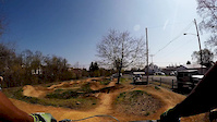
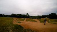
Bike & Skill Parks
| name | type | city | rating |
|---|---|---|---|
| Middle Run Pump Track | skill park | Newark |
Activity Type Stats
| activitytype | trails | distance | descent | descent distance | total vertical | rating | global rank | state rank | photos | reports | routes | ridelogs |
|---|---|---|---|---|---|---|---|---|---|---|---|---|
| Mountain Bike | 119 | 86 miles | 6,634 ft | 30 miles | 364 ft | #344 | #127 | 276 | 2,269 | 22 | 32,872 | |
| E-Bike | 4 | 3 miles | 367 ft | 2 miles | 249 ft | 1,882 | 3 | 902 | ||||
| Gravel Bike | 15 | #507 | #1,070 | 21 | 190 | |||||||
| Adaptive Bike | 12 | #547 | #1,847 | 2 | ||||||||
| Winter Fat Bike | 14 | #338 | #1,121 | 4 | ||||||||
| Horse | 15 | 22 miles | 1,125 ft | 6 miles | 253 ft | #1,729 | #982 | 177 | 1 | |||
| Hike | 138 | 99 miles | 8,136 ft | 36 miles | 371 ft | #1,847 | #806 | 5 | 2,251 | 4 | 1,322 | |
| Trail Running | 138 | 99 miles | 8,136 ft | 36 miles | 371 ft | #1,499 | #524 | 2,251 | 4 | 1,553 | ||
| Snowshoe | 38 | 35 miles | 3,425 ft | 13 miles | 322 ft | #589 | #227 | 146 | 3 | |||
| Backcountry Ski | 38 | 35 miles | 3,425 ft | 13 miles | 322 ft | #415 | #91 | 146 | 12 | |||
| Nordic Ski | 1 | 1,394 ft | 16 ft | 1 | 3 |
Frequently Asked Questions About Newark
▼
What are the best places to ride in Newark?
Newark has 7 areas to explore for mountain biking. The top rated areas are:
▼
What are the highest rated mountain biking trails in Newark?
The highest rated mountain biking trails in Newark are:
- White Clay Skills Park (4.5/5)
- Corkscrew (4.3/5)
- Snow Goose (4.3/5)
- Tri Valley - Snow Goose (4.3/5)
- Double Horseshoe Trail (4.2/5)
▼
What is the best time of the year to ride in Newark?
Based on ride log data, the most popular months to ride in Newark are:
- July (550 activities)
- June (495 activities)
- September (466 activities)
▼
Where can I park to ride in Newark?
There are 26 parking locations listed in Newark. The most popular parking spots are: View all parking and trailhead locations on the map to plan your visit.
Activities
Trails
- By brenthillier
 NSMBA TRAILFORKS & contributors
 - Admins: DSP
- #3465 - 7,561 views
- newark activity log | embed map of Newark mountain bike trails | newark mountain biking points of interest
Downloading of trail gps tracks in kml & gpx formats is enabled for Newark.
You must login to download files.