close
-
Layers w
- Weather Layers
- Pro
- Pro
- Pro
- Pro
- Pro
- Pro
- More Layers
- Pro
- Pro
- Pro
- Pro
-
Upgrade to

3D
Trail Conditions
- Unknown
- Snow Groomed
- Snow Packed
- Snow Covered
- Snow Cover Partial
- Freeze/thaw Cycle
- Icy
- Prevalent Mud
- Wet
- Variable
- Ideal
- Dry
- Very Dry
Trail Flow (Ridden Direction)
Trailforks scans users ridelogs to determine the most popular direction each trail is ridden. A good flowing trail network will have most trails flowing in a single direction according to their intension.
The colour categories are based on what percentage of riders are riding a trail in its intended direction.
The colour categories are based on what percentage of riders are riding a trail in its intended direction.
- > 96%
- > 90%
- > 80%
- > 70%
- > 50%
- < 50%
- bi-directional trail
- no data
Trail Last Ridden
Trailforks scans ridelogs to determine the last time a trail was ridden.
- < 2 days
- < 1 week
- < 2 weeks
- < 1 month
- < 6 months
- > 6 months
Trail Ridden Direction
The intended direction a trail should be ridden.
- Downhill Only
- Downhill Primary
- Both Directions
- Uphill Primary
- Uphill Only
- One Direction
Contribute Details
Colors indicate trail is missing specified detail.
- Description
- Photos
- Description & Photos
- Videos
Trail Popularity ?
Trailforks scans ridelogs to determine which trails are ridden the most in the last 9 months.
Trails are compared with nearby trails in the same city region with a possible 25 colour shades.
Think of this as a heatmap, more rides = more kinetic energy = warmer colors.
- most popular
- popular
- less popular
- not popular
ATV/ORV/OHV Filter
Max Vehicle Width
inches
US Cell Coverage
Legend

Radar Time
Activity Recordings
Trailforks uses anonymized public activity data.
?
Activity Recordings
Trailforks uses anonymized public activity data.
?
Personal Heatmap
▶
Activity Types
all
/
none
▶
Options
2
Date range
month
–
Winter Trails
Warning
A routing network for winter maps does not exist. Selecting trails using the winter trails layer has been disabled.
Missing Trails
Most Popular
Least Popular
Trails are colored based on popularity. The more popular a trail is, the more red. Less popular trails trend towards green.
Jump Magnitude Heatmap
Heatmap of where riders jump on trails. Zoom in to see individual jumps, click circles to view jump details.
BC Backroad Status
![map legend]()
Service Road Atlas is a free to use, community-driven service for viewing and creating reports on the numerous back-country service roads around B.C. and Alberta.

Slope Aspect
Direction the slope faces
Trails Deemphasized
Trails are shown in grey.
Only show trails with no bike usage.
Suggested Layers
Based on selected activity type
Save the current map location and zoom level as your default home location whenever this page is loaded.
Save
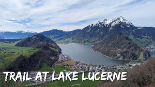
No description for Nidwalden has been added yet!
Login or register to submit one.
This region uses the Uk/Euro style trail grading system.
Region Details
- 7
- 11
- 26
- 38
- 24
Stats
- Avg Trail Rating
- Trails (view details)
- 112
- Trails Mountain Bike
- 106
- Trails E-Bike
- 77
- Trails Hike
- 112
- Trails Trail Running
- 112
- Total Distance
- 83 miles
- Total Descent
- 59,526 ft
- Total Vertical
- 6,350 ft
- Highest Trailhead
- 7,794 ft
- Reports
- 333
- Photos
- 72
- Ridden Counter
- 3,072
Sub Regions
- Beckenried (15)
- Buochs (3)
- Emmetten (4)
- Ennetbürgen (17)
- Bürgenstock (17)
- Ennetmoos (6)
- Hergiswil NW (15)
- Stans (17)
- Wolfenschiessen (29)
Popular Nidwalden Mountain Biking Trails
• 95 ★ 3.5 • 712 ft • 255 ft • 157 • • hike
Hike-a-bike to access and continue to Lopper trail
• 90 ★ 4.3 • 1 mile • 3 ft • 154 • • hike
Technical trail which gives you many opportunities for different line choices. This trail offers almost everything. From fast rough sections with thousands of roots to rather flow parts. A must-do trail with an All-Mountain or Enduro bike.
• 85 ★ 4.2 • 1 mile • 87 ft • 138 • • hike
Lustiger Trail der mehrheitlich flowig ist mit anfänglich ein paar technischen Stellen.
• 85 ★ 3.7 • 1,430 ft • 0 ft • 113 • • hike
ideal continuation of the . Still a lots of roots, but definitely steeper in this section
• 95 ★ 3.4 • 3,757 ft • 34 ft • 103 • • hike
Popular red difficulty singletrack. This hike primary trail can be used downhill primary and has a moderate overall physical rating with a 34 ft blue climb. Trail visibility is always easy to follow. On average it takes 19 minutes to complete this trail.
• 50 ★ 3.7 • 2 miles • 30 ft • 89 •
Moderately popular red difficulty singletrack. This multi-use trail can be used downhill primary and has a moderate overall physical rating with a 30 ft blue climb. On average it takes 27 minutes to complete this trail.
Nidwalden Mountain Bike Routes
★ 5.0 • 18 miles • 5,027 ft • 2 •
Up out of Buochs to Klewenalp, onto Bärenfellen, drop down to Niederrickenbach Dorf, round the...
Photos of Nidwalden Mountain Bike
Videos of Nidwalden Mountain Bike

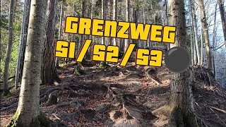
trail: Grenzweg S3
9:52 |
46 |
Dec 12, 2025 , Hergiswil NW

trail: Grenzweg S2
9:52 |
36 |
Dec 12, 2025 , Hergiswil NW
trail: Grenzweg S1
9:52 |
82 |
Dec 12, 2025 , Hergiswil NW
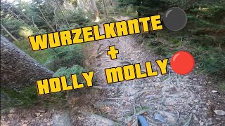
trail: Wurzelkante
15:05 |
56 |
Dec 12, 2025 , Hergiswil NW
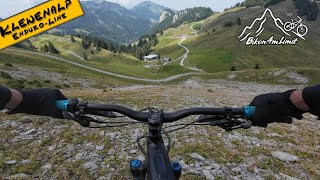
trail: Niederbauen DH
3:26 |
76 |
Sep 18, 2025 , Emmetten
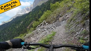
trail: Chol-Tal Trail
4:11 |
116 |
May 25, 2025 , Emmetten
youtuber
![Did we Survive a day of Roots and Rocks? //...]()

trail: Wurzelkante
7:39 |
323 |
Sep 16, 2024 , Hergiswil NW
trail: Nas Intro
7:30 |
146 |
Mar 29, 2024 , Ennetbürgen
Recent Trail Reports
Activity Feed
| username | action | type | title | date |
|---|---|---|---|---|
| erePmT | ridden | trail | activity #97185331 | Jun 17, 2026 @ 8:21am 18 hours |
| 5EWbsL | vote | trail | activity #96793125 | Jun 12, 2026 @ 3:58am Jun 12, 2026 |
| rbaumi | wishlist | trail | activity #96431630 | Jun 6, 2026 @ 10:38pm Jun 6, 2026 |
| Pedromptorres | wishlist | trail | activity #96225093 | Jun 4, 2026 @ 7:14am Jun 4, 2026 |
| Pedromptorres | wishlist | trail | activity #96224499 | Jun 4, 2026 @ 7:04am Jun 4, 2026 |
Recent Comments
| username | type | title | comment | date |
|---|---|---|---|---|
| trail | Wanderweg! Wurde saniert, jetzt viele neue... | May 30, 2026 @ 2:32am May 30, 2026 | ||
| trail | Fast ZU trocken… | May 30, 2026 @ 2:28am May 30, 2026 | ||
| trail | Gestern fast trocken für die steilen Abschnitte | May 30, 2026 @ 2:27am May 30, 2026 | ||
| trail | Gestern fast zu trocken, aber perfekt | May 30, 2026 @ 2:23am May 30, 2026 | ||
| trail | Gestern perfekt | May 30, 2026 @ 2:21am May 30, 2026 |
Local Badges
-

Descent 100k Badge0 awarded -
Descent 100k Badge0 awarded -
Descent 100k Badge0 awarded -
Descent 100k Badge0 awarded -
Descent 100k Badge0 awarded -

Descent 10k Badge0 awarded
Activity Type Stats
| activitytype | trails | distance | descent | descent distance | total vertical | rating | global rank | state rank | photos | reports | routes | ridelogs |
|---|---|---|---|---|---|---|---|---|---|---|---|---|
| Mountain Bike | 106 | 76 miles | 53,973 ft | 57 miles | 6,335 ft | 72 | 333 | 1 | 6,208 | |||
| E-Bike | 77 | 57 miles | 36,870 ft | 41 miles | 4,239 ft | 314 | 7 | 330 | ||||
| Hike | 112 | 83 miles | 59,528 ft | 62 miles | 6,352 ft | 327 | 1 | 938 | ||||
| Trail Running | 112 | 83 miles | 59,528 ft | 62 miles | 6,352 ft | 326 | 1 | 96 |
Activities
Trails
Points of Interest
- By brenthillier
 NSMBA TRAILFORKS & contributors
 - Admins: swiss, trailpapst
- #8954 - 4,336 views
- nidwalden activity log | embed map of Nidwalden mountain bike trails |
Downloading of trail gps tracks in kml & gpx formats is enabled for Nidwalden.
You must login to download files.