close
-
Layers w
- Weather Layers
- Pro
- Pro
- Pro
- Pro
- Pro
- Pro
- More Layers
- Pro
- Pro
- Pro
- Pro
-
Upgrade to

3D
Trail Conditions
- Unknown
- Snow Groomed
- Snow Packed
- Snow Covered
- Snow Cover Partial
- Freeze/thaw Cycle
- Icy
- Prevalent Mud
- Wet
- Variable
- Ideal
- Dry
- Very Dry
Trail Flow (Ridden Direction)
Trailforks scans users ridelogs to determine the most popular direction each trail is ridden. A good flowing trail network will have most trails flowing in a single direction according to their intension.
The colour categories are based on what percentage of riders are riding a trail in its intended direction.
The colour categories are based on what percentage of riders are riding a trail in its intended direction.
- > 96%
- > 90%
- > 80%
- > 70%
- > 50%
- < 50%
- bi-directional trail
- no data
Trail Last Ridden
Trailforks scans ridelogs to determine the last time a trail was ridden.
- < 2 days
- < 1 week
- < 2 weeks
- < 1 month
- < 6 months
- > 6 months
Trail Ridden Direction
The intended direction a trail should be ridden.
- Downhill Only
- Downhill Primary
- Both Directions
- Uphill Primary
- Uphill Only
- One Direction
Contribute Details
Colors indicate trail is missing specified detail.
- Description
- Photos
- Description & Photos
- Videos
Trail Popularity ?
Trailforks scans ridelogs to determine which trails are ridden the most in the last 9 months.
Trails are compared with nearby trails in the same city region with a possible 25 colour shades.
Think of this as a heatmap, more rides = more kinetic energy = warmer colors.
- most popular
- popular
- less popular
- not popular
ATV/ORV/OHV Filter
Max Vehicle Width
inches
US Cell Coverage
Legend

Radar Time
Activity Recordings
Trailforks uses anonymized public activity data.
?
Activity Recordings
Trailforks uses anonymized public activity data.
?
Personal Heatmap
▶
Activity Types
all
/
none
▶
Options
2
Date range
month
–
Winter Trails
Warning
A routing network for winter maps does not exist. Selecting trails using the winter trails layer has been disabled.
Missing Trails
Most Popular
Least Popular
Trails are colored based on popularity. The more popular a trail is, the more red. Less popular trails trend towards green.
Jump Magnitude Heatmap
Heatmap of where riders jump on trails. Zoom in to see individual jumps, click circles to view jump details.
BC Backroad Status
![map legend]()
Service Road Atlas is a free to use, community-driven service for viewing and creating reports on the numerous back-country service roads around B.C. and Alberta.

Slope Aspect
Direction the slope faces
Trails Deemphasized
Trails are shown in grey.
Only show trails with no bike usage.
Suggested Layers
Based on selected activity type
Save the current map location and zoom level as your default home location whenever this page is loaded.
Save
No description for North Gorge has been added yet!
Login or register to submit one.
 google parking directions
Primary Trail Type: All-Mountain & Downhill
Land Status: Managed by Local Riding Association
google parking directionsLinks
Activities Click to view
- Mountain Bike
6 trails
- Hike
4 trails
- Trail Running
4 trails
Region Details
- 3
- 2
- 1
Region Status
Caution as of Oct 27, 2025Local Trail Association
Stats
- Avg Trail Rating
- Trails (view details)
- 6
- Trails Mountain Bike
- 6
- Trails Hike
- 4
- Trails Trail Running
- 4
- Total Distance
- 3 miles
- Total Descent
- 693 ft
- Total Vertical
- 133 ft
- Highest Trailhead
- 696 ft
- Reports
- 11
- Photos
- 29
- Ridden Counter
- 59
Popular North Gorge Mountain Biking Trails
• 5 ★ 5.0 • 2,346 ft • 32 ft • 13 •
Less popular blue difficulty singletrack. This mountain bike primary trail can be used downhill only and has a hard overall physical rating with a 32 ft blue climb. It features berm and jump. On average it takes 7 minutes to complete this trail.
• 5 ★ 5.0 • 1,770 ft • 66 ft • 12 •
Less popular green difficulty singletrack. This mountain bike primary trail. On average it takes 5 minutes to complete this trail.
• 5 ★ 5.0 • 2,282 ft • 75 ft • 12 •
Less popular black diamond difficulty singletrack. This mountain bike primary trail can be used downhill only. On average it takes 8 minutes to complete this trail.
• 5 ★ 5.0 • 3,267 ft • 119 ft • 11 •
Less popular green difficulty singletrack. This mountain bike primary trail. On average it takes 9 minutes to complete this trail.
• 5 ★ 3.0 • 3,845 ft • 225 ft • 8 •
Less popular blue difficulty singletrack. This mountain bike primary trail. On average it takes 30 minutes to complete this trail.
• 5 ★ 5.0 • 2,430 ft • 129 ft • 3 •
Less popular green difficulty singletrack. This mountain bike primary trail. On average it takes 17 minutes to complete this trail.
North Gorge Mountain Bike Routes
8 miles • 789 ft • 0 • Loop •
Great Cardio loop with enough rocks to make the climbs a little techy. Some is crushed limestone, some is...
Photos of North Gorge Mountain Bike
Videos of North Gorge Mountain Bike
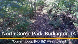
trail: Current Loop (North)
5:39 |
18 |
Nov 12, 2025 , Burlington
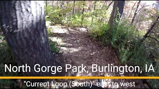
trail: Current Loop (South)
2:45 |
17 |
Nov 12, 2025 , Burlington
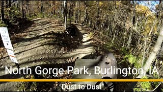
trail: Dust To Dust
2:29 |
27 |
Nov 8, 2025 , Burlington
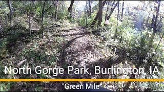
trail: Green Mile
2:56 |
19 |
Oct 29, 2025 , Burlington
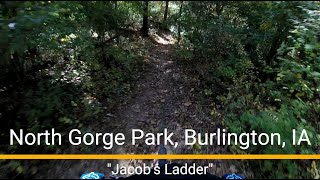
trail: Jacob's Ladder
4:57 |
26 |
Oct 29, 2025 , Burlington
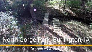
trail: Ashes To Ashes
3:13 |
32 |
Oct 28, 2025 , Burlington
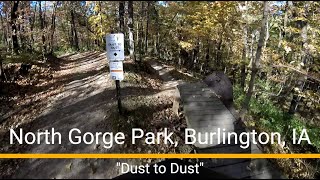
trail: Dust To Dust
0:24 |
25 |
Oct 28, 2025 , Burlington
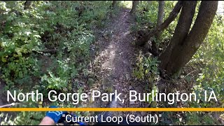
trail: Current Loop (South)
3:53 |
24 |
Oct 28, 2025 , Burlington
Recent Trail Reports
| status | trail | date | condition | info | user |
|---|---|---|---|---|---|
| Dust To Dust | Oct 27, 2025 @ 10:14am (America/Chicago) Oct 27, 2025 | Dry | ryechard | ||
| Green Mile | Oct 27, 2025 @ 10:14am (America/Chicago) Oct 27, 2025 | Dry | ryechard | ||
| Jacob's Ladder | Oct 27, 2025 @ 10:14am (America/Chicago) Oct 27, 2025 | Dry | ryechard | ||
| Ashes To Ashes | Oct 27, 2025 @ 10:14am (America/Chicago) Oct 27, 2025 | Dry | ryechard | ||
| Current Loop (North) | Oct 27, 2025 @ 10:14am (America/Chicago) Oct 27, 2025 | Dry | ryechard |
Activity Feed
| username | action | type | title | date |
|---|---|---|---|---|
| ryechard | add | video | activity #84041302 and 1 more | Nov 12, 2025 @ 2:27pm Nov 12, 2025 |
| ryechard | add | photo | activity #84032317 | Nov 12, 2025 @ 11:31am Nov 12, 2025 |
| ryechard | add | video | activity #83828263 | Nov 8, 2025 @ 7:47pm Nov 8, 2025 |
| ryechard | add | video | activity #83215278 and 1 more | Oct 29, 2025 @ 8:18am Oct 29, 2025 |
| ryechard | add | photo | activity #83213401 and 5 more | Oct 29, 2025 @ 7:28am Oct 29, 2025 |
Nearby Areas
| name | distance | ||||
|---|---|---|---|---|---|
| Dehn's Trails | 2 | 2.4 km | |||
| Geode State Park | 1 | 14 km | |||
| Big River State Forest | 14.8 km | ||||
| Spring Lake Park | 5 | 4 | 9 | 32.1 km | |
| Argyle Lake State Park | 3 | 3 | 32.9 km |
Activity Type Stats
| activitytype | trails | distance | descent | descent distance | total vertical | rating | global rank | state rank | photos | reports | routes | ridelogs |
|---|---|---|---|---|---|---|---|---|---|---|---|---|
| Mountain Bike | 6 | 3 miles | 692 ft | 1 mile | 135 ft | #5,422 | #1,965 | 28 | 11 | 1 | 67 | |
| Hike | 4 | 2 miles | 472 ft | 4,787 ft | 135 ft | #20,133 | #10,075 | 8 | 7 | |||
| Trail Running | 4 | 2 miles | 472 ft | 4,787 ft | 135 ft | #18,790 | #9,001 | 8 |
Frequently Asked Questions About North Gorge
▼
What are the highest rated mountain biking trails in North Gorge?
The highest rated mountain biking trails in North Gorge are:
- Ashes To Ashes (4.1/5)
- Current Loop (North) (4.1/5)
- Dust To Dust (4.1/5)
- Current Loop (South) (4.1/5)
- Green Mile (4.1/5)
▼
Where can I park to ride in North Gorge?
There are 1 parking locations listed in North Gorge. The most popular parking spots are:
▼
What is the longest trail in North Gorge?
The longest trail in North Gorge is Jacob's Ladder at 3,845 ft. View all trails sorted by distance.
▼
How many trails are in North Gorge?
North Gorge has a total of 6 trails. Browse top mountain biking trails in North Gorge to find detailed information including difficulty ratings, distances, and trail conditions.
- By Chop1869
 & contributors
 - Admins: apply
- #23597 - 2,955 views
- north gorge activity log | embed map of North Gorge mountain bike trails | north gorge mountain biking points of interest
Downloading of trail gps tracks in kml & gpx formats is enabled for North Gorge.
You must login to download files.