close
-
Layers w
- Weather Layers
- Pro
- Pro
- Pro
- Pro
- Pro
- Pro
- More Layers
- Pro
- Pro
- Pro
- Pro
-
Upgrade to

3D
Trail Conditions
- Unknown
- Snow Groomed
- Snow Packed
- Snow Covered
- Snow Cover Partial
- Freeze/thaw Cycle
- Icy
- Prevalent Mud
- Wet
- Variable
- Ideal
- Dry
- Very Dry
Trail Flow (Ridden Direction)
Trailforks scans users ridelogs to determine the most popular direction each trail is ridden. A good flowing trail network will have most trails flowing in a single direction according to their intension.
The colour categories are based on what percentage of riders are riding a trail in its intended direction.
The colour categories are based on what percentage of riders are riding a trail in its intended direction.
- > 96%
- > 90%
- > 80%
- > 70%
- > 50%
- < 50%
- bi-directional trail
- no data
Trail Last Ridden
Trailforks scans ridelogs to determine the last time a trail was ridden.
- < 2 days
- < 1 week
- < 2 weeks
- < 1 month
- < 6 months
- > 6 months
Trail Ridden Direction
The intended direction a trail should be ridden.
- Downhill Only
- Downhill Primary
- Both Directions
- Uphill Primary
- Uphill Only
- One Direction
Contribute Details
Colors indicate trail is missing specified detail.
- Description
- Photos
- Description & Photos
- Videos
Trail Popularity ?
Trailforks scans ridelogs to determine which trails are ridden the most in the last 9 months.
Trails are compared with nearby trails in the same city region with a possible 25 colour shades.
Think of this as a heatmap, more rides = more kinetic energy = warmer colors.
- most popular
- popular
- less popular
- not popular
ATV/ORV/OHV Filter
Max Vehicle Width
inches
US Cell Coverage
Legend

Radar Time
Activity Recordings
Trailforks uses anonymized public activity data.
?
Activity Recordings
Trailforks uses anonymized public activity data.
?
Personal Heatmap
▶
Activity Types
all
/
none
▶
Options
2
Date range
month
–
Winter Trails
Warning
A routing network for winter maps does not exist. Selecting trails using the winter trails layer has been disabled.
Missing Trails
Most Popular
Least Popular
Trails are colored based on popularity. The more popular a trail is, the more red. Less popular trails trend towards green.
Jump Magnitude Heatmap
Heatmap of where riders jump on trails. Zoom in to see individual jumps, click circles to view jump details.
BC Backroad Status
![map legend]()
Service Road Atlas is a free to use, community-driven service for viewing and creating reports on the numerous back-country service roads around B.C. and Alberta.

Slope Aspect
Direction the slope faces
Trails Deemphasized
Trails are shown in grey.
Only show trails with no bike usage.
Suggested Layers
Based on selected activity type
Save the current map location and zoom level as your default home location whenever this page is loaded.
Save
No description for Nova Gorica has been added yet!
Login or register to submit one.
This region uses the Uk/Euro style trail grading system.
Region Supporters & Maintainers
![]()
TCS Nova GoricaBuilder- TCS
trail builderMaintainer
Activities Click to view
- Mountain Bike
41 trails
- E-Bike
30 trails
- Adaptive Bike
0 trails
- Winter Fat Bike
0 trails
- Hike
18 trails
- Trail Running
18 trails
Region Details
- 9
- 3
- 9
- 10
- 7
- 1
Region Status
Caution as of 19 hoursStats
- Avg Trail Rating
- Trails (view details)
- 41
- Trails Mountain Bike
- 41
- Trails E-Bike
- 30
- Trails Horse
- 1
- Trails Hike
- 18
- Trails Trail Running
- 18
- Trails Downhill Ski
- 1
- Trails Nordic Ski
- 1
- Total Distance
- 42 miles
- Total Descent
- 20,765 ft
- Total Vertical
- 1,899 ft
- Highest Trailhead
- 2,129 ft
- Reports
- 1,156
- Photos
- 244
- Ridden Counter
- 5,121
Sub Regions
-
TCS trail network
- 3
- 9
- 2
- 1
-
TCS trail network / Mark MTB
-
TCS trail network / Sabotin
-
TCS trail network / Škabrijel
-
TCS trail network / Sveta Gora
Popular Nova Gorica Mountain Biking Trails
• 100 ★ 5.0 • 2 miles • 56 ft • 406 •
Zahtevne objekte je mogoče obvoziti, več srednje zahtevnih objektov nima obvoza
• 90 ★ 4.7 • 2 miles • 0 ft • 296 •
Lep singletrack, pri katerem se tako podlaga kot stil vožnje stalno spreminja. Začne z bolj kamnitim delom, nato se prevesi čez rob v strmejši del. V gozdu z borovci je zelo lepa pot z dvignjenimi ovinki, ki v spodnjem delu preide v...
• 95 ★ 4.8 • 1,798 ft • 0 ft • 241 •
Lažja varianta zadnjega odseka zgornjega dela. Narejeni dvignjeni ovinki, na izhodu skok, ki ga je mogoče prevoziti. A lighter variant of the last section on the upper part. Made raised bends, at the exit a jump that can be drived.
• 100 ★ 5.0 • 1,339 ft • 3 ft • 200 •
An alternative route of Kraljica trail. More natural terrain.
• 85 ★ 4.9 • 3,517 ft • 27 ft • 193 •
Highly rated popular blue difficulty family friendly singletrack. This mountain bike primary trail and has a moderate overall physical rating with a 27 ft blue climb. It features berm, bridge, drop, jump, gap jump and ladder bridge. Trail visibility is always easy to follow. On average it takes 7 minutes to complete this trail.
• 90 ★ 4.5 • 640 ft • 0 ft • 143 •
Popular red difficulty singletrack. This mountain bike primary trail and has a moderate overall physical rating with a 0 ft blue climb. It features berm, drop and jump. Trail visibility is always easy to follow. On average it takes 2 minutes to complete this trail.
• 70 ★ 5.0 • 1,791 ft • 7 ft • 113 •
Popular blue difficulty family friendly singletrack. This mountain bike primary trail and has a moderate overall physical rating with a 7 ft blue climb. It features berm and drop. Trail visibility is sometimes hard to follow. On average it takes 3 minutes to complete this trail.
Nova Gorica Mountain Bike Routes
★ 3.0 • 7 miles • 2,135 ft • 4 •
Tra gli artisti e intellettuali che si possono definire “interventisti” quello di Arturo Toscanini è...
27 miles • 2,509 ft • 0 • Loop •
Rožna Dolina (Nova Gorica) - Stara Gora - Volčja Draga - Vogrsko - Lago Vogršček - Fiume Lijak -...
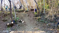
Photos of Nova Gorica Mountain Bike
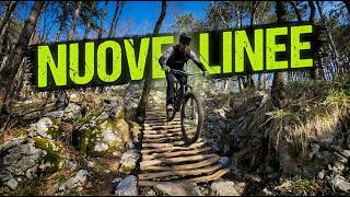
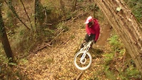
Videos of Nova Gorica Mountain Bike

trail: Kraljica - Sv.Gora // TCS ®
3:02 |
|
Mar 28, 2024

trail: Kraljica - Sv.Gora // TCS ®
3:02 |
|
Mar 27, 2024

trail: Kraljica - Sv.Gora // TCS ®
3:02 |
|
Mar 27, 2024

trail: Kraljica - Sv.Gora // TCS ®
3:02 |
1 |
Mar 27, 2024
0:23 |
|
Jan 17, 2022
trail: Bataljonka // TCS ®
11:32 |
20 |
Apr 17, 2026 , Nova Gorica
2:26 |
14030 |
Apr 10, 2012
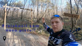
trail: Zvjrk
19:04 |
106 |
Jul 31, 2025 , Nova Gorica
Recent Trail Reports
Activity Feed
| username | action | type | title | date |
|---|---|---|---|---|
| matL | add | report | activity #97338198 | Jun 19, 2026 @ 12:39pm 16 hours |
| matL | add | report | activity #97047339 | Jun 15, 2026 @ 9:34am Jun 15, 2026 |
| raffaelemtb | ridden | trail | activity #96726450 | Jun 11, 2026 @ 3:31am Jun 11, 2026 |
| wsepp | ridden | trail | activity #96432200 | Jun 6, 2026 @ 11:05pm Jun 6, 2026 |
| sebobo | comment | report | activity #96346918 | Jun 6, 2026 @ 12:54am Jun 6, 2026 |
Recent Comments
| username | type | title | comment | date |
|---|---|---|---|---|
| report | Thanks for the info! 🙏 | Jun 6, 2026 @ 12:54am Jun 6, 2026 | ||
| report | Sorry for the inconvenience, some grumpy hiker... | Jun 5, 2026 @ 11:39pm Jun 5, 2026 | ||
| trail | Epic trail!! Super stoked to be able to do a... | Oct 20, 2025 @ 2:22am Oct 20, 2025 | ||
| trail | Awesome Trail guys - big thx | Aug 19, 2025 @ 9:24am Aug 19, 2025 | ||
| trail | Congratulations to the grail builder. Really... | Aug 7, 2025 @ 5:05am Aug 7, 2025 |
Local Badges
-

Epic Mountain Bike Climb 2k125 awarded -

Climbing 10k Badge46 awarded -

Mountain Biking 100k Badge2 awarded -

Epic Ride Descent 2k125 awarded -

Descent 10k Badge52 awarded -

Descent 100k Badge2 awarded
Activity Type Stats
| activitytype | trails | distance | descent | descent distance | total vertical | rating | global rank | state rank | photos | reports | routes | ridelogs |
|---|---|---|---|---|---|---|---|---|---|---|---|---|
| Mountain Bike | 41 | 42 miles | 20,764 ft | 23 miles | 1,900 ft | #1,242 | #5 | 238 | 1,156 | 2 | 7,534 | |
| E-Bike | 30 | 36 miles | 17,388 ft | 20 miles | 1,900 ft | #342 | #1 | 5 | 1,091 | 1 | 1,621 | |
| Horse | 1 | 1,148 ft | 203 ft | 1,073 ft | 207 ft | 15 | ||||||
| Hike | 18 | 26 miles | 8,166 ft | 10 miles | 1,890 ft | #760 | #4 | 1 | 975 | 851 | ||
| Trail Running | 18 | 26 miles | 8,166 ft | 10 miles | 1,890 ft | #1,583 | #12 | 975 | 222 | |||
| Downhill Ski | 1 | 1,148 ft | 203 ft | 1,073 ft | 207 ft | |||||||
| Nordic Ski | 1 | 1,148 ft | 203 ft | 1,073 ft | 207 ft | 31 |
Frequently Asked Questions About Nova Gorica
▼
What are the best places to ride in Nova Gorica?
Nova Gorica has 4 areas to explore for mountain biking. The top rated areas are:
▼
What are the highest rated mountain biking trails in Nova Gorica?
The highest rated mountain biking trails in Nova Gorica are:
- Kraljica - Sv.Gora // TCS ® (4.8/5)
- Prašičja - Hogwarts // TCS ® (4.5/5)
- Škabrijelka // TCS ® (4.5/5)
- Zvjrk (4.3/5)
- Jelenova - Deer Trail // TCS ® (4.3/5)
▼
What is the best time of the year to ride in Nova Gorica?
Based on ride log data, the most popular months to ride in Nova Gorica are:
- November (46 activities)
- May (45 activities)
- August (43 activities)
▼
Where can I park to ride in Nova Gorica?
There are 5 parking locations listed in Nova Gorica. The most popular parking spots are: View all parking and trailhead locations on the map to plan your visit.
Activities
Trails
- By riccardop & contributors
- Admins: VjekoslavKrsanac, zocknroll, TCS
- #18434 - 18,375 views
- nova gorica activity log | embed map of Nova Gorica mountain bike trails | nova gorica mountain biking points of interest polygons
Downloading of trail gps tracks in kml & gpx formats is enabled for Nova Gorica.
You must login to download files.